Southeast Europe (49,293 – 28,578 BCE): Upper …
Years: 49293BCE - 28578BCE
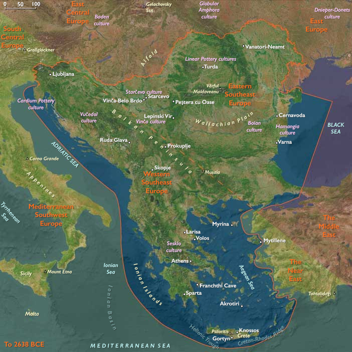
Southeast Europe (49,293 – 28,578 BCE): Upper Pleistocene I — Ice, Karst, and River Corridors at the Crossroads of Continents
Geographic and Environmental Context
During the height of the last glacial cycle, Southeast Europe formed one of the great hinge zones of Eurasia — the meeting ground between the Danubian steppe, the Adriatic–Aegean coastlines, and the mountainous Balkans.
Yet, as elsewhere in The Twelve Worlds, the region was less a single landscape than a set of semi-independent natural worlds, linked more by movement than by unity.
-
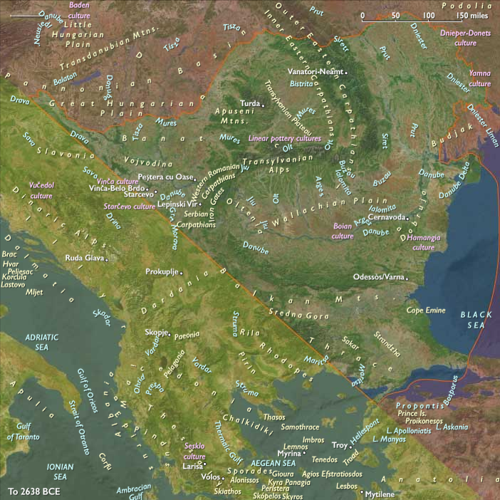
To the northeast, Eastern Southeast Europe—the Lower Danube Plain, Iron Gates, and Dobruja uplands—lay exposed to continental winds, forming a periglacial frontier that looked northward toward the loess plains of Central Europe.
-
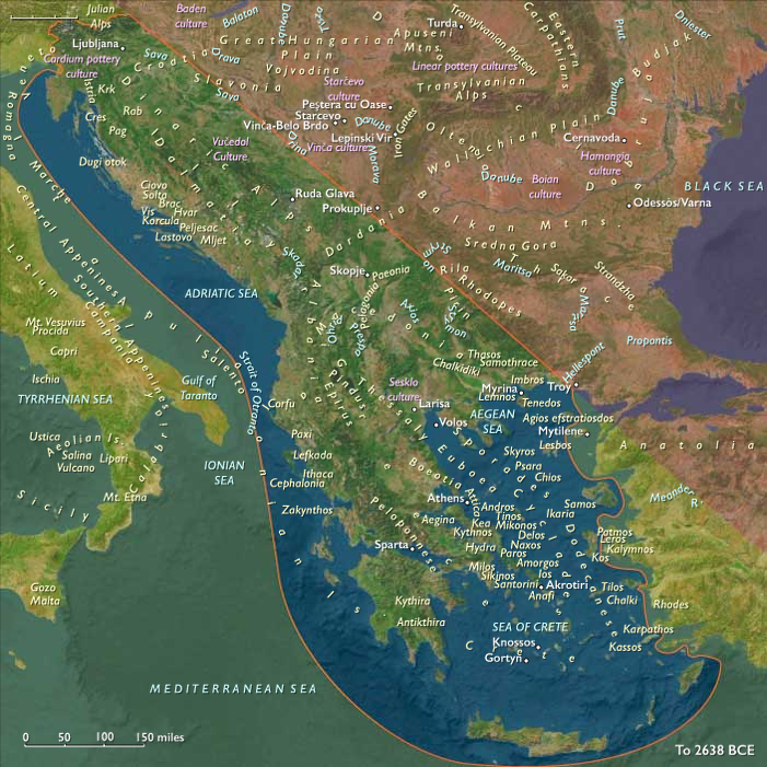
To the southwest, Western Southeast Europe—the Adriatic–Ionian karst belt of Croatia, Bosnia, Albania, and Greece—was milder, fractured, and coastal: a refuge of caves and cliffs, connected culturally to Italy and the Mediterranean basins.
-
Between them rose the mountain heartland—the Balkans and Rhodopes, dissected by deep valleys that acted alternately as barriers and conduits depending on the severity of the cold.
Across these contrasting worlds, glacial winds, ice-fed rivers, and karstic refuges structured human movement and memory, binding the Danube corridor to the Adriatic shores through a web of seasonal passages and symbolic ties.
Climate and Environmental Shifts
Southeast Europe lay directly in the path of the shifting polar front.
The Last Glacial Maximum brought cold, dry, and windy conditions, with strong seasonality and extensive loess accumulation across northern plains.
-
In Eastern Southeast Europe, steppe–tundra spread across the Danube Plain and the Carpathian forelands, interrupted by gallery forests along meltwater streams.
-
In the Adriatic karst, temperatures were less extreme; precipitation fell as winter snow or spring rain, feeding caves and limestone springs that formed oases in an otherwise barren landscape.
-
Along the Aegean, fluctuating sea level—often 80–100 m lower than today—exposed a vast coastal shelf that joined many of the present islands to the mainland, widening foraging zones but also reshaping coastlines.
Brief interstadials punctuated the long cold: short-lived warm pulses allowed grasses, shrubs, and forests to return, giving temporary abundance to river valleys before the next advance of ice and dust reset the system.
Lifeways and Settlement Patterns
Human presence across these worlds was thin yet persistent, adapted to extreme variability through mobility and ecological flexibility.
-
In Eastern Southeast Europe, small forager bands camped along Danube terraces and loess promontories, targeting migratory herds of horse, reindeer, and bison. The Iron Gates gorges offered ice-free winter refugia where the river cut through the Carpathian front, concentrating fish and game.
-
In Western Southeast Europe, foragers relied on a dual economy of hunting and coastal gathering. Sheltered karst caves and rockshelters in Istria, Dalmatia, and Epirus served as seasonal bases; coastal plains—now submerged—provided shellfish, seabirds, and tunny during warmer intervals.
-
In the interior highlands, upland valleys hosted seasonal hunting camps that followed red deer and ibex herds between lower forest patches and mountain snowline pastures.
These adaptive patterns were neither isolated nor synchronous. Eastern groups followed the rhythms of continental steppe migrations, while western and southern groups synchronized their calendars with Mediterranean currents and the pulse of spring rains. The region as a whole operated as a gradient of survival strategies, not a unified system.
Technology and Material Culture
A broadly shared Upper Paleolithic tradition linked the region’s foragers to the larger European world, yet each subregion expressed it differently.
-
Eastern Southeast Europe developed rich blade and microblade industries, suited to big-game hunting and hide working. Caves and loess sites yielded burins, endscrapers, and bone points, often associated with hearth features and ochre-stained sediments.
-
Western Southeast Europe maintained similar toolkits but diversified them with marine shell ornaments, amber beads, and small engraved stones — signs of symbolic elaboration likely tied to seasonal aggregation in coastal refugia.
-
Across the mountains, tailored clothing, portable fire kits, and hafted composite tools show that people carried both technology and tradition across ecozones.
Ochre use was widespread, and burials — when found — display the same symbolic care evident from the Franco-Cantabrian to the Don: red pigment, ornamentation, and deliberate positioning within the landscape.
Movement and Interaction Corridors
Geography and ice dictated movement.
Three principal corridors connected the subregions and extended the region’s reach:
-
The Danube–Morava–Vardar Axis linked the northern plains to the Aegean world, allowing fauna, people, and ideas to flow between the steppe and the Mediterranean.
-
The Adriatic Shelf—exposed during glacial lowstands—served as a seasonal migration plain and coastal highway, connecting Dalmatia, Apulia, and the Ionian shores.
-
The Carpathian–Balkan Passes provided east–west transit between river and coast, facilitating the diffusion of stone, amber, and ornament styles.
Through these corridors, Southeast Europe remained in dialogue with its neighbors: the Danube steppe with Central Europe, the Adriatic karst with Italy, and the Aegean margin with Anatolia. It was a hinge, not a border.
Cultural and Symbolic Expressions
Symbolic and ritual behaviors reveal both unity and divergence.
Caves from Istria to Thrace bear evidence of ochre use, ornament caches, and ritual hearths. Portable engravings and figurines—sometimes human, sometimes hybrid—echo the mythic grammar shared across the Ice Age world.
The Iron Gates gorges, already by this period, began to serve as persistent aggregation zones, revisited for millennia thereafter.
In coastal karst, burial and habitation often blended: caves doubled as both dwellings and ancestral repositories, rooting communities in cyclical patterns of return.
Environmental Adaptation and Resilience
Survival depended on versatility.
Populations cycled between open steppe hunting in cold phases and riverine or coastal specialization in milder interludes.
Their success rested on mobility across ecozones, knowledge of migratory game and fish cycles, and symbolic practices that sustained social cohesion in times of isolation.
Fire, clothing, and social networks proved as vital as tools.
Transition Toward the Last Glacial Maximum
By 28,578 BCE, Southeast Europe stood poised between two worlds:
to the north, the continental ice; to the south, the emerging temperate refugia of the Mediterranean.
Its three subregions—Danubian steppe, Adriatic karst, and Aegean–Balkan corridor—remained largely independent, yet continually braided by exchange and migration.
In this interplay lay the region’s enduring pattern: a chain of distinct ecological theaters linked more strongly to their counterparts in neighboring regions than to one another.
Southeast Europe thus embodies The Twelve Worlds’ central insight—that regions are not coherent wholes but crossroads of adjacent worlds, each conserving its own rhythm within the shared drama of human persistence at the edge of ice.
Topics
Commodoties
Subjects
Regions
Subregions
Related Events
Showing 10 events out of 69706 total
Years: 49293BCE - 28578BCE
Topics
Commodoties
Subjects
Regions
Subregions