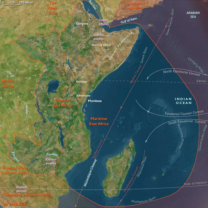
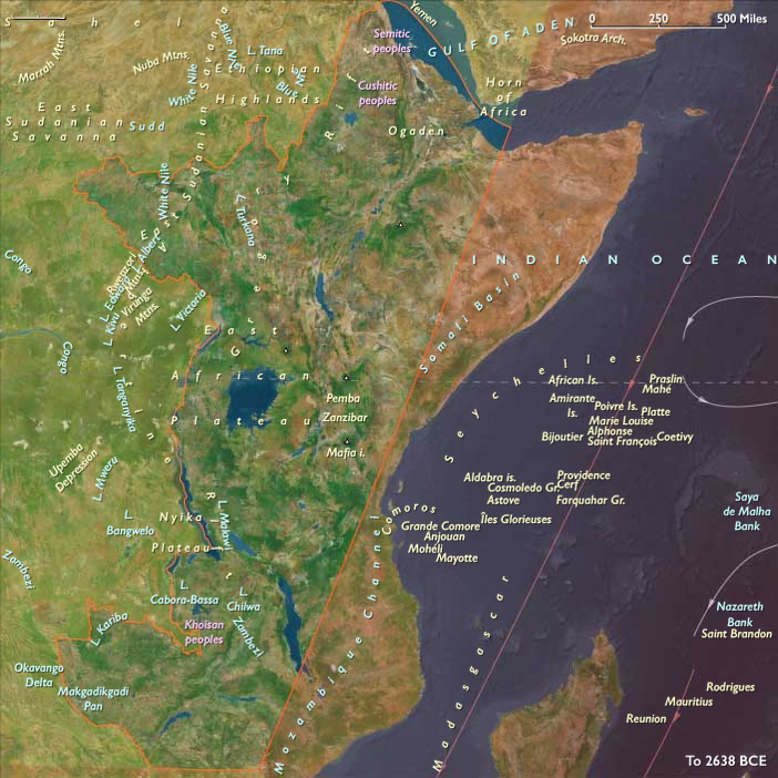
…Kalambo Falls in eastern Africa, sites dating …
Years: 256653BCE - 235918BCE
…Kalambo Falls in eastern Africa, sites dating to more than two hundred thousand years ago) has proven to be a more effective forager than its predecessor, with the ability to kill even large animals with fire-hardened wooden spears.
According to conventional theory, these archaic humans, who settled in all parts of Africa, evolved gradually toward modern forms, their skulls becoming more rounded, skeletons less robust, and molar teeth smaller.
H. ergaster is thought to be the first hominin to vocalize.
As H. heidelbergensis developed, more sophisticated culture proceeded from this point.
Locations
Groups
Topics
Commodoties
Subjects
Regions
Subregions
Related Events
Filter results
Showing 10 events out of 69751 total
Homo erectus (a species of human best known from finely made handaxes and other butchery tools found at locations like Isimila and …
Prehistory of the Netherlands: A Landscape Shaped by Water
The prehistory of the region that is now the Netherlands was largely shaped by the sea and rivers, which continuously shifted the low-lying geography over millennia. The dynamic interplay of water and land influenced human settlement patterns, with early inhabitants gravitating toward higher ground as the landscape evolved.
Early Human Presence: Neanderthal Traces near Maastricht
- The oldest known human traces in the region belong to Neanderthals, whose presence dates back approximately 250,000 years.
- These remains have been discovered in higher, more stable soils near Maastricht, an area less affected by the flood-prone terrain of the lowlands.
- The Neanderthals likely adapted to a changing environment, utilizing the resources of rivers and forests for survival.
A Landscape in Constant Flux
Throughout prehistory, the region’s geological and climatic changes played a crucial role in shaping early habitation:
- Glacial and interglacial periods altered sea levels, periodically expanding and contracting habitable land.
- The Rhine, Meuse, and Scheldt rivers created fertile but unstable floodplains, influencing settlement choices.
- Rising sea levels and sediment deposits led to the formation of peat bogs and coastal dunes, features that would later define the Dutch landscape.
These early environmental factors set the stage for the later development of prehistoric cultures, as humans adapted to a land in flux, balancing the challenges of water management with the rich resources provided by the rivers and coastlines.
Homo erectus becomes extinct, with the known exception of Solo Man in Indonesia, by around 200,000 BCE, while Earth’s only remaining hominid, Homo sapiens Neanderthalensis, or Neanderthal Man, has spread into Europe and the Middle East.
The Neandertals, unlike Homo erectus, have brains similar in size to—or possible larger than—those of modern humans, although Neandertal brains are lighter in front and heavier in back.
They match modern humans in body weight, but are generally shorter, stockier and more muscular.
Although similar in appearance to modern humans, Neandertals have the large teeth, pronounced eyebrow ridges, protuberant jaws, receding chin, and sloping forehead associated with Homo erectus.
The similarity of their tongue bones to those of modern humans suggests that the Neandertals are fully capable of speech.
The Neandertals are the first hominids (as far as is known) to bury their dead and to actively care for aged and crippled members of their communities.
The fact that Neandertal graves contain food indicates a belief in some form of afterlife, although no grave goods have turned up.
Like previous members of the genus Homo, they have tamed fire and use it to roast meat and other foods.
The large animals hunted by the Neandertals include the giant cave bears, the mammoth, and the woolly rhinoceros.
Neandertaler stone implements represent distinct improvement over the tools of Homo erectus: more delicate, more precise, and more varied.
No artwork has been discovered in association with Neandertal sites.
The Indian Ocean World, one of the twelve divisions of the Earth, is centered on the Indian Ocean and encompasses Madagascar, several small island groups, Maritime East Africa, Southeastern Arabia, Southern India, Sri Lanka, and Aceh—the northernmost tip of Sumatra. Its southernmost point is Kerguelen Island.
To the north of Madagascar, the island nations of the Comoros and the Seychelles are situated in the western Indian Ocean, while Mauritius lies to the east of the great island.
On the African mainland, the region includes portions of Mozambique, Malawi, Tanzania, Kenya, and Somalia, all of which also have cultural and historical ties to Afroasia.
The Arabian nations of Yemen and Oman face the heart of the Indian Ocean World, with their division aligning with the traditional boundary separating North India from South India and Sri Lanka.
To the west of Southern India, the Maldives form a prominent island chain within this maritime world.
Along the northeastern boundary, only Aceh, the northwesternmost tip of Sumatra, belongs to the Indian Ocean World, distinguishing it from the rest of the Indonesian archipelago.
HistoryAtlas contains 1,059 entries for the Indian Ocean World from the Paleolithic period to 1899.
Narrow results by searching for a word or phrase or select from one or more of a dozen filters.
Homo erectus, long settled in sparse communities throughout East Asia, probably becomes extinct in China before 200,000 BCE, evidently replaced by Homo sapiens.
Primitive humans first migrate to the Indian subcontinent between 400,000 and 200,000 BCE; some of them possibly sail to southern India from eastern Africa.
The approximate time of divergence from the common ancestor of all modern human populations was two hundred thousand years ago, based on evidence from studies of molecular biology.
The broad study of African genetic diversity found the ǂKhomani San people to express the greatest genetic diversity among the 113 distinct populations sampled, making them one of fourteen "ancestral population clusters".
The research also located the origin of modern human migration in southwestern Africa, near the coastal border of Namibia and Angola.
Anatomically modern humans first appear in the fossil record in Africa about one hundred and ninety-five thousand years ago, and studies of molecular biology give evidence that the approximate time of divergence from the common ancestor of all modern human populations was two hundred thousand years ago.
Twentieth-century archaeologists will find fragments of anatomically modern humans in Omo in southwestern Ethiopia.
The results of potassium-argon dating of the tuffs, published in February 2005, attribute them to circa one hundred and ninety-five thousand years ago, making Ethiopia the current choice for the ‘cradle of Homo Sapiens’.
The bones, which include two partial skulls, four jaws, a legbone, around two hundred teeth and several other parts, were found between 1967 and 1974.
They are now assumed to be considerably older than the one hundred and sixty thousand-year-old Herto remains designated Homo sapiens idaltu, which had been thought to be the earliest humans, and suggests that, if humans did originate in Africa as is currently thought, they did not expand from there for much longer than previously thought.
It also suggests that H. sapiens sapiens evolved alongside other hominids for a considerable time before the other hominids became extinct.
Part of the skull of a nine-year old child from the Grotte du Lazaret (English: Cave of Le Lazaret), a cave now in the eastern suburbs of the French town of Nice and now overlooking the Mediterranean Sea, suggests that either Homo heidelbergensis or a proto-Neanderthal group occupied it almost two hundred thousand years ago.
The Lazaret cave dwellers evidently represent a transitional form between Homo erectus and more advanced species of early humans.
Southern Oceania encompasses Eastern East Antarctica, Tasmania, New Zealand’s South Island (including its southern coast), and Australia, extending northward to the continent’s Top End and Cape York Peninsula.
The term Australasia (French: Australasie) was coined by Charles de Brosses in Histoire des navigations aux terres australes (1756). Derived from Latin, meaning "south of Asia," the term was intended to distinguish this region from Polynesia (to the east) and the southeastern Pacific (Magellanica).
Southern Oceania’s southwestern boundary divides East Antarctica into its Western and Eastern subregions, running from the South Pole to the Kerguelen Islands. These islands, among the most remote on Earth, form part of the Kerguelen Plateau, a vast igneous geological province largely submerged beneath the southern Indian Ocean.
The French Southern and Antarctic Lands (Terres australes et antarctiques françaises)—which include Adélie Land, the Crozet Islands, the Kerguelen Islands, Amsterdam and Saint Paul Islands, and France’s Scattered Islands in the Indian Ocean—are administered as a separate district.
The southeastern boundary runs a little north of the Cook Strait, which separates New Zealand’s South Island—sometimes called the "mainland"—from the smaller yet more populous North Island (Te Ika-a-Māui).
The northern boundary divides Southern Oceania from The Far East, to which Australia’s tropical north belongs.
HistoryAtlas contains 569 entries for Southern Oceania from the Paleolithic period to 1899.
Narrow results by searching for a word or phrase or select from one or more of a dozen filters.
