Pech Merle: A Window into Prehistoric Art …
Years: 21645BCE - 19918BCE
Pech Merle: A Window into Prehistoric Art and Life
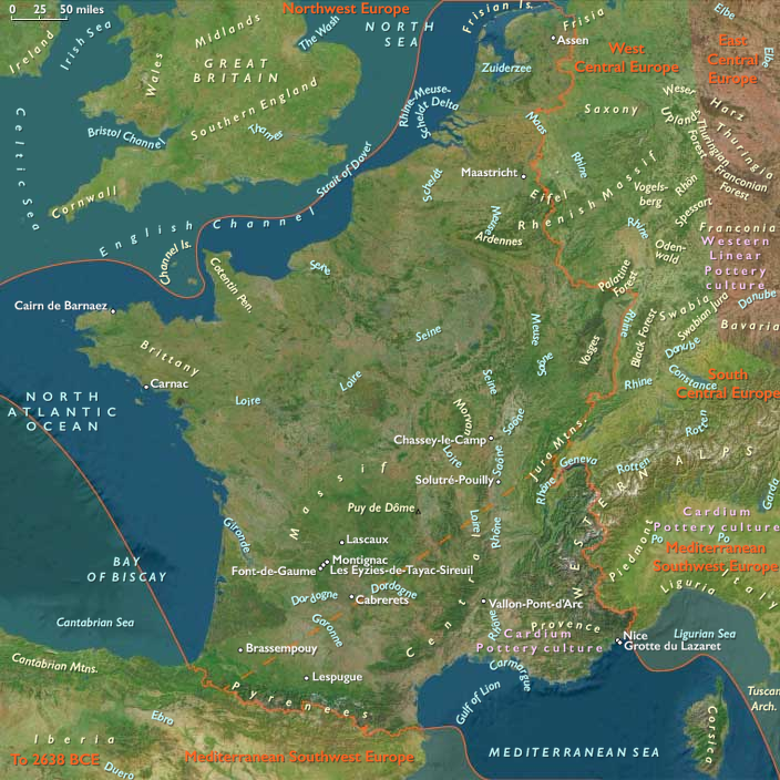
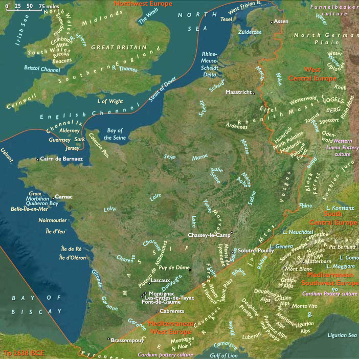
Located in the Lot département of the Midi-Pyrénées region, near Cabrerets, Pech Merle is one of the few prehistoric cave painting sites in France still open to the public. This vast cave system, extending more than a mile from its entrance, preserves some of the most stunning murals of the Upper Paleolithic period.
Prehistoric Art at Pech Merle
-
The cave features dramatic murals dating from the Gravettian culture (c. 25,000 BCE), though some engravings and paintings may be from the Magdalenian era (c. 16,000 BCE).
-
Seven chambers contain lifelike depictions of:
- Woolly mammoths
- Spotted horses and single-color horses
- Bovids and reindeer
- Human figures and handprints
-
One of Pech Merle’s most famous images is the "Spotted Horses" panel, depicting two horses with distinctive black spots, surrounded by hand stencils—a masterpiece of prehistoric symbolic expression.
Cave Use and Preservation
- During the Ice Age, the cave likely served as a refuge for prehistoric peoples, offering shelter from the Arctic climate and extreme conditions.
- A great river once flowed through the region, cutting underground passages that were later used by early humans.
- Children’s footprints, preserved in ancient clay half a mile underground, provide rare evidence of human movement deep within the caves.
A Sealed Time Capsule of Prehistoric Life
- Over time, earth movements and rain sealed the cave entrances, preserving the artwork in near-perfect condition until its discovery in the 20th century.
- Within a six-mile radius of Pech Merle, there are ten other caves with Upper Paleolithic art, though none are open to the public.
Pech Merle stands as a remarkable testament to early human creativity and survival, offering a rare glimpse into the artistic, cultural, and environmental realities of Ice Age Europe.
Locations
Groups
Topics
Commodoties
Subjects
Regions
Subregions
Related Events
Filter results
Showing 10 events out of 21 total
East Polynesia (820–1971 CE): Isolation, Contact, and Cultural Persistence
Political and Social Developments
Initial Settlement and Community Formation
Between approximately 800 and 1200 CE, Polynesian settlers reached and established communities on Easter Island (Rapa Nui) and the Pitcairn Islands. These communities developed distinct cultural identities and social structures, adapting to their isolated environments.
Chiefdoms and Social Organization
Rapa Nui evolved into a complex chiefdom society characterized by hierarchical leadership structures and extensive clan-based organization. Pitcairn Islands experienced smaller-scale societal structures due to their limited land and resource bases.
European Contact and Subsequent Impacts
European explorers first made contact with Easter Island in 1722 and the Pitcairn Islands in 1767. These interactions significantly disrupted traditional societies through disease, resource exploitation, and demographic decline.
Economic and Technological Developments
Sustainable Resource Management
Island economies centered on agriculture, fishing, and bird hunting, tailored to local ecosystems. Easter Islanders notably developed sophisticated agricultural systems, including stone gardens (manavai), and managed marine resources sustainably.
Introduction of European Technology
European contact brought new technologies, including metal tools, firearms, and ships, profoundly altering traditional economies and resource management strategies. These changes reshaped livelihoods and community dynamics significantly.
Cultural and Artistic Developments
Monumental Architecture and Sculpture
Rapa Nui is renowned for its monumental stone statues (moai), reflecting sophisticated engineering and artistic capabilities. These sculptures hold cultural and religious significance, symbolizing ancestral veneration and social hierarchy.
Preservation of Traditional Knowledge
Despite external disruptions, islanders preserved traditional navigational skills, oral histories, and artisanal practices. Cultural expressions persisted, demonstrating resilience amid extensive demographic and social challenges.
Religious Developments
Indigenous Religious Practices
Religious practices centered around ancestor worship, natural deities, and ceremonial rites that reinforced community cohesion and social order. Rituals included elaborate ceremonies and offerings, reflecting deep spiritual connections to the environment.
Influence of Christianity
Christianity was introduced primarily during the 19th century, significantly transforming religious beliefs and practices. Indigenous spirituality often syncretized with Christian beliefs, shaping contemporary religious landscapes.
Long-Term Consequences and Historical Significance
The period from 820 to 1971 CE profoundly shaped East Polynesia through initial settlement, cultural flourishing, external contacts, and socio-economic transformations. These developments underscore the resilience and adaptability of isolated Pacific societies, leaving lasting legacies that continue to influence regional identities and global perspectives on sustainability and cultural heritage.
South America (1828–1971 CE)
Republics, Frontiers, and the Modern Continent
Geographic Definition of South America
The region of South America encompasses all lands south of the Isthmus of Panama, including the subregions of South America Major—stretching from Colombia and Venezuela through Brazil, Bolivia, Peru, Ecuador, Paraguay, Uruguay, and northern Argentina and Chile—and Peninsular South America, which includes southern Chile, southern Argentina, Patagonia, Tierra del Fuego, the Falkland Islands (Islas Malvinas), and the Juan Fernández Islands.
Anchors include the Andes cordillera, the Altiplano, the Amazon, Orinoco, and Magdalena river systems, the Gran Chaco, the Llanos, the Pampas, and the Patagonian steppe, reaching south to the Strait of Magellan and the sub-Antarctic seas. This continental expanse unites rainforest and desert, mountain and plain, forming the world’s largest tropical forest system and one of its most diverse temperate frontiers.
Geography and Political Frontiers
Between 1828 and 1971, South America completed its transition from colonial empires to a constellation of modern nation-states. The nineteenth century was an age of consolidation—of borders, capitals, and frontiers—while the twentieth introduced urbanization, industrialization, and social revolution.
In the north and center, the Andes and Amazon defined the heartlands of South America Major: Brazil’s vast interior was opened by coffee, railways, and later industry; Peru, Bolivia, and Chile struggled over mineral frontiers; and the River Plate republics forged new economies on cattle and grain.
Farther south, Peninsular South America—Patagonia, Tierra del Fuego, and the southern islands—shifted from Indigenous autonomy to national incorporation under Chile, Argentina, and Britain. The conquest of Indigenous lands completed the continental frame of modern South America.
Climate and Environmental Shifts
With the close of the Little Ice Age, climate gradually warmed, though variability remained pronounced.
-
Andes: Glacial retreat altered water regimes; earthquakes and volcanic eruptions repeatedly struck Chile and Peru.
-
Amazon basin: Rainfall oscillated between flood and drought decades; deforestation and frontier ranching began to modify hydrology by the mid-twentieth century.
-
Llanos, Chaco, and Pampas: Drought and locust plagues punctuated otherwise fertile cycles; agriculture expanded through mechanization.
-
Patagonia and southern Chile: Winds remained fierce but temperatures moderated, fostering European colonization and ranching.
Environmental transformation followed human frontiers: new roads, plantations, and mines redrew both ecology and economy.
Subsistence and Settlement
Agrarian foundations persisted even as industry grew.
-
Andean republics: Highland farmers maintained terraced maize and potato fields; haciendas, mines, and plantations supplied global markets with silver, tin, and copper.
-
Brazil: Coffee, sugar, and later industrial production in São Paulo and Rio de Janeiro powered national growth; Amazon rubber boomed and collapsed; steel and oil replaced gold.
-
River Plate region: Argentina and Uruguay exported beef, wool, and grain, their estancias mechanized by the early twentieth century. Paraguay remained agrarian after its devastation in the War of the Triple Alliance (1864–1870).
-
Northern Andes and Caribbean coasts: Cocoa, coffee, and oil wealth transformed Venezuela and Colombia; pipelines and ports knit the mountains to the sea.
-
Southern Chile and Argentina: Wheat, forestry, and later nitrate and copper mining followed Indigenous dispossession; sheep ranching dominated Patagonia; Tierra del Fuego mixed gold rushes and estancias.
-
Falklands and Juan Fernández: Remote yet strategic, they sustained small ranching and fishing communities within imperial or national frameworks.
Urbanization intensified: Buenos Aires, São Paulo, Lima, Santiago, Bogotá, Caracas, and Montevideo became centers of power, drawing millions from countryside and abroad.
Technology and Material Culture
Railways, telegraphs, and steamships linked interior basins to coastal ports.
By the 1880s, rail lines climbed the Andes and spanned pampas and deserts; river steamers plied the Amazon, Orinoco, and Paraná–Paraguay. Telegraphs and later telephones connected capitals; radio and cinema shaped modern culture.
Architecture mirrored aspiration: neoclassical capitols, baroque cathedrals, and art-nouveau theaters proclaimed republican modernity. Industrialization—from Chilean copper smelters to Brazilian steel mills—transformed material life. Yet regional craft traditions endured: Andean textiles, Afro-Brazilian percussion, Mapuche weaving, and Amazonian ceramics sustained living heritage.
Movement and Interaction Corridors
Continental circulation reached unprecedented scale:
-
Migration: European settlers (Italian, German, Spanish, Japanese) repopulated Brazil, Argentina, Chile, and Uruguay; internal migration urbanized Andean and coastal cities.
-
Rivers and rails: The Amazon, Paraguay, and Magdalena bound hinterlands to export ports.
-
Trade: Coffee, copper, nitrates, beef, and wool flowed to Atlantic and Pacific markets; oil joined after 1910.
-
Integration projects: Early customs unions evolved into the ABC Pact (Argentina–Brazil–Chile) and the Latin American Free Trade Association (1960).
-
Frontier expansion: Settlers, surveyors, and soldiers extended national authority into Amazonian forests and Patagonian plains, binding peripheries to capitals.
Cultural and Symbolic Expressions
Nations built mythologies of liberation and progress.
Romantic and modernist writers—José Hernández, Machado de Assis, Rubén Darío, Gabriela Mistral, Pablo Neruda, and Jorge Luis Borges—forged continental literatures. Visual art ranged from Andean costumbrismo to Mexican and Brazilian muralism, celebrating Indigenous and African heritage as foundations of identity.
Catholicism remained pervasive yet plural: popular pilgrimages and saints’ festivals persisted beside secular nationalism and new Protestant and Spiritist movements.
In the south, national narratives glorified frontier conquest; in the north, Andean and Amazonian cosmologies reemerged through indigenismo. Across the continent, dance and music—samba, tango, cueca, candombe, and vallenato—embodied the fusion of African, Indigenous, and European rhythms.
Environmental Adaptation and Resilience
Traditional ecological systems endured beneath modernization:
Andean terraces and irrigation persisted; Amazonian forest gardens maintained biodiversity; smallholders and Indigenous communities adapted global crops—potatoes, maize, cassava—to local microclimates.
Mechanized agriculture and deforestation redefined landscapes: soybean expansion in Brazil, sheep and wheat in Patagonia, sugar and cotton in northeast Brazil.
By the 1960s, environmental awareness emerged—parks in the Andes, conservation on Juan Fernández, and debates over Amazonian deforestation signaling a new consciousness of ecological limits.
Technology and Power Shifts (Conflict Dynamics)
The century and a half after independence was marked by recurring upheaval:
-
Wars and diplomacy: The War of the Triple Alliance (1864–1870), War of the Pacific (1879–1883), and border arbitrations defined national boundaries.
-
Social transformation: Abolition of slavery (Brazil, 1888), land reforms (Bolivia, Mexico, mid-20th century), and peasant mobilization challenged oligarchies.
-
Political cycles: Liberal republics gave way to populist and military regimes—Vargas in Brazil, Perón in Argentina, Velasco Alvarado in Peru—each promising modernization and social justice.
-
Revolution and reaction: Bolivia’s 1952 revolution, Cuba’s 1959 example, and guerrilla movements in Colombia and Venezuela framed Cold War geopolitics.
-
Southern frontiers: Argentina and Chile militarized Patagonia and Tierra del Fuego; Britain maintained the Falklands; boundary disputes simmered through the 20th century.
Technological change—aviation, electrification, oil extraction, and hydroelectric power—accelerated modernization while deepening regional inequality.
Transition (to 1971 CE)
By 1971, South America was a continent of contradictions: industrial cities beside impoverished rural zones, democratic ideals shadowed by coups, and booming exports amid environmental decline.
In the north, Brazil, Venezuela, and Colombia led industrial and oil economies; in the south, Argentina, Chile, and Uruguay oscillated between prosperity and political crisis.
The Amazon, Andes, and Patagonia—long the continent’s ecological and symbolic pillars—entered the modern age as frontiers of extraction, conservation, and imagination.
From the Inca terraces to the steel towers of São Paulo, from the Guiana forests to the Falklands sheep ranges, South America by 1971 stood as a continent unified by geography yet divided by history—its republics striving toward equity, identity, and stewardship in a world it had long supplied, inspired, and endured.
South America Major (1828–1971 CE)
Republics, Frontiers, and Modern Transformations
Geographic Definition of South America Major
The subregion of South America Major encompasses all lands north of the Río Negro, extending across the full continental span of Brazil, Uruguay, Paraguay, northern Argentina and northern Chile, Bolivia, Peru, Ecuador(excluding the Cape lands at the Isthmian boundary), Colombia (excluding the Darién region, which belongs to Isthmian America), Venezuela, Guyana, Suriname, and French Guiana.
Anchors include the Andes cordillera and Altiplano, the Amazon basin, the Orinoco and Magdalena river systems, the Venezuelan Llanos, the Gran Chaco, the Uruguayan Pampas, and the Guiana Shield.
Bounded by Isthmian America to the north and Subcontinental South America to the south, this subregion forms the continental heartland of South America—linking the Pacific and Atlantic worlds through its intertwined highlands, forests, plains, and river systems.
Geography and Political Frontiers
Between 1828 and 1971, South America Major evolved from newly independent republics into a mosaic of modern nations. The Andes continued to define borders and identity; the Amazon, Gran Chaco, and Pampas became frontiers of settlement, extraction, and nation-building. The century and a half after independence saw shifting alliances, wars over territory, and the gradual incorporation of frontier zones into national economies.
The Pacific coast urbanized through ports like Lima, Guayaquil, and Valparaíso; Atlantic Brazil expanded through coffee and industry; and inland Bolivia, Paraguay, and Uruguay became landlocked crossroads of diplomacy and struggle. The Guianas remained colonial or semi-colonial enclaves until mid-century decolonization.
Climate and Environmental Shifts
The retreat of the Little Ice Age brought modest warming and rainfall fluctuations:
-
Andes and Altiplano: Melting glaciers improved water availability for valleys but also triggered landslides and floods.
-
Amazon basin: Rainfall cycles alternated between flood and drought decades, with deforestation beginning to affect local climates by the 20th century.
-
Gran Chaco and Pampas: Droughts and locust plagues recurred through the 19th century; by the 20th, cattle ranching and grain cultivation transformed the landscape.
-
Guiana forests and Llanos: Continued to alternate between wet and dry extremes, sustaining biodiversity yet increasingly opened by logging, mining, and plantations.
Environmental volatility shaped settlement patterns but also spurred innovation—irrigation in Andean valleys, drainage of pampas wetlands, and hydroelectric development along major rivers.
Subsistence and Settlement
Post-independence economies remained agrarian but diversified steadily:
-
Andean republics (Peru, Bolivia, Ecuador, Colombia): Highland peasants maintained terraced maize–potato rotations; haciendas and plantations expanded in valleys. Mining revived—silver and tin in Bolivia, guano and nitrate in Peru, oil in Ecuador and Colombia.
-
Brazil: Transitioned from sugar and gold to coffee (São Paulo, Rio de Janeiro), rubber (Amazon), and later industrial production (Belo Horizonte, São Paulo, Rio Grande do Sul).
-
River Plate region (Argentina, Uruguay, Paraguay): Cattle and sheep ranching dominated, later joined by grain exports. Paraguay remained rural after devastating wars; Uruguay balanced pastoral exports and political stability.
-
Venezuela and Colombia: Coffee, cocoa, and oil reshaped economies; ranching persisted in the Llanos.
-
Guianas: Plantation agriculture (sugar, rice) persisted under British, French, and Dutch control, worked by Afro-descended and Indo-Asian laborers.
Urbanization accelerated: Buenos Aires, Rio de Janeiro, Lima, Santiago, Bogotá, Quito, and Caracas became political and economic capitals, concentrating power and population.
Technology and Material Culture
Railways, telegraphs, and steamships integrated fragmented landscapes.
In the 19th century, rail lines climbed the Andes (e.g., Oroya Railway, Quito–Guayaquil) and linked interior ranches and mines to ports. Steam navigation on the Amazon and Paraná–Paraguay rivers expanded trade and migration.
European architectural styles—neoclassical capitals, baroque churches, and eclectic civic buildings—symbolized modernization.
Local crafts persisted: Andean textiles, Amazonian ceramics, Guaraní carvings, and Afro-Brazilian percussion instruments. By the 20th century, industrialization brought steelworks (São Paulo, Caracas), automobiles (Buenos Aires), and aviation links across the continent.
Movement and Interaction Corridors
Continental circulation intensified:
-
River systems: The Amazon, Orinoco, Paraná–Paraguay, and Magdalena became arteries of commerce and colonization.
-
Rail networks: Linked mines and ranches to ports, knitting national markets.
-
Migration: Italian, German, Spanish, and Japanese immigrants settled Brazil, Argentina, Uruguay, and Paraguay, transforming agriculture and culture.
-
Slave emancipation and internal migration: Brazil abolished slavery in 1888, and freed populations moved into cities and frontiers.
-
Oil routes: Pipelines and refineries in Venezuela, Colombia, and Ecuador shifted economies toward energy export.
Regional trade blocs, from early customs unions to mid-20th-century cooperation schemes, sought continental integration, while European and North American investment reshaped industrial growth.
Cultural and Symbolic Expressions
National identities crystallized from colonial legacies.
Romantic nationalism and liberal reform inspired literature, painting, and architecture celebrating Indigenous and creole heritage: Bolívarian epics, José Hernández’s Martín Fierro, Machado de Assis, Rubén Darío, and Andean costumbrismo.
In the 20th century, modernismo, muralism (led by Diego Rivera and Cándido Portinari), and revolutionary art redefined visual culture.
Catholicism remained pervasive but adapted: popular pilgrimages (e.g., Virgen de Copacabana, Círio de Nazaré) coexisted with secular nationalism and Protestant missions.
Afro-descended and Indigenous cultural forms—candomblé, samba, marimba, and Andean panpipe music—entered national consciousness as emblems of authenticity.
Environmental Adaptation and Resilience
Peasant and Indigenous communities maintained ecological knowledge despite land concentration:
-
Highland terraces and irrigation persisted for local autonomy.
-
Amazonian forest management—rubber tapping, shifting gardens, and agroforestry—balanced extraction with sustainability until industrial overreach in the mid-20th century.
-
Ranching and agriculture expanded dramatically across the Pampas and cerrado, transforming ecosystems.
-
Dams and deforestation along the Amazon and Paraná altered river regimes by the 1960s, initiating modern environmental debates.
Throughout, traditional practices—from Andean vertical exchange to Guaraní collective farming—anchored cultural and ecological continuity.
Technology and Power Shifts (Conflict Dynamics)
Wars and revolutions marked the region’s political evolution:
-
Post-independence conflicts: Civil wars, caudillo rivalries, and frontier disputes shaped early republics.
-
Major wars: War of the Triple Alliance (1864–1870) decimated Paraguay; War of the Pacific (1879–1883) redrew borders between Chile, Peru, and Bolivia.
-
Reforms and revolutions: Abolition of slavery (Brazil 1888), republican overthrow of the monarchy (Brazil 1889), and land reforms in Mexico and Bolivia signaled social transformation.
-
20th-century shifts: Populist regimes (Vargas in Brazil, Perón in Argentina), revolutions (Bolivia 1952, Cuba 1959), and guerrilla movements (Colombia, Venezuela) redefined state–society relations.
-
External influences: The Good Neighbor Policy and Cold War interventions tied the region to U.S. geopolitical strategies, particularly during the 1960s and early 1970s.
Technological modernization—railways, telephones, automobiles, oil drilling, and aviation—interwove with social upheaval and uneven industrialization.
Transition (to 1971 CE)
By 1971, South America Major had completed its passage from colonial dependency to diverse modernity.
The region’s republics faced contrasts: booming urban economies alongside rural poverty, democratic aspirations shadowed by coups and authoritarianism.
The Andes still bore terraces and mines older than empire; the Amazon and Guianas remained ecological frontiers; and the Pampas and Llanos powered global agriculture.
From liberation heroes to modern reformers, the quest for sovereignty, equity, and identity defined this long age.
Despite enduring inequality and deforestation, South America Major emerged as a continent of resilience—its highlands, forests, plains, and coasts still bound by the enduring geography that had shaped all its worlds.
Scholars will debate whether the uprising against Balmaceda was mainly a fight over political or economic privileges, but the bulk of research will support the primacy of political over economic issues.
From the 1830s to the 1880s, Congress has gradually asserted more and more authority over the budget and over cabinet ministers.
Balmaceda tries to circumvent this budgetary power and break the hold of congressmen and local bosses on congressional elections.
The controversial downfall of Chilean President Jose Manuel Balmaceda Fernandez (1886-91) represents the only occasion when power is transferred by force between 1830 and 1924.
This event results in the most important alteration in the constitutional system between 1833 and 1925.
In many respects, the Balmaceda episode is the culmination of two trends: the growing strength of Congress in relation to the president, and the expanding influence of foreign capital in the mining zone.
In essence, the rebels oppose Balmaceda's plans to expand the role of the executive branch in the political and economic systems.
The Chilean Congress leads a revolt against Balmaceda in 1891, complaining about the heavy-handed rule of the president, and in particular his interference in congressional elections,.
Conservatives generally support the rebels; Liberals and Democrats back the president.
Along with some renegade Liberals, the newly emergent Radical Party aligns with the so-called congressionalists, not wishing to see legislative prerogatives curtailed just as the party is gaining clients and strength.
Those provincials resentful of the growing centralization of political and economic power in and around Santiago also back the rebellion, especially in the north.
Initially, the navy, the armed service that includes the highest percentage of aristocrats, sides with the rebels; the army sides with the president.
The Chilean rebellion also attracts British entrepreneurs worried by Balmaceda's threat to encroach on the independence and revenues of the foreign-owned nitrate mines.
Although not opposed to foreign investment, Balmaceda had proposed a greater role for the state and higher taxes in the mining sector.
Tension had mounted because nitrate sales are in a slump, a recurring problem because of the volatility of that commodity's price on international markets.
The most famous British mine owner is John North, the "nitrate king," who is angry that his nitrate railroad monopoly has been terminated by Balmaceda.
The United States, although not directly involved, supports Balmaceda as the legal president.
The insurgents win Chile's bloody but brief Civil War of 1891 when the army decides not to fight the navy.
As a result of the rebel victory, Congress becomes dominant over the chief executive and the nitrate mines increasingly fall into British and North American hands.
Having gained asylum in the Argentine embassy, Balmaceda waits until the end of his legal presidential term, then commits suicide.
As Diego Portales had become a legendary hero to the right, so Balmaceda will later be anointed by the left as an economic nationalist who sacrificed his life in the struggle for Chilean liberation.
United States-Chilean relations, already tense as a result of the civil war over Balmaceda, deteriorate further as a result of the Baltimore incident.
In late 1891, sailors from the U.S.S. Baltimore brawl with Chileans during shore leave in Valparaiso.
To avert a war with an angry United States, the Chilean government apologizes and pays reparations.
This final ecclesiastical struggle for control of Ecuador is in vain, however.
By the end of the Liberals' rule in 1925, Roman Catholicism will no longer be the constitutionally mandated state religion, official clerical censorship of reading material will have been suppressed, many powerful foreign clergy will have been expelled, education will have been secularized, civil marriage as well as divorce will have been instituted, the concordat with the Vatican will have been broken, most of the church's rural properties will have been seized by the state, and the republic will no longer be dedicated to the Sacred Heart of Jesus.
The Roman Catholic Church in Ecuador will never again hold prerogatives as extensive as those it has enjoyed during the late nineteenth century.
Years: 21645BCE - 19918BCE
Locations
Groups
Topics
Commodoties
Subjects
Regions
Subregions