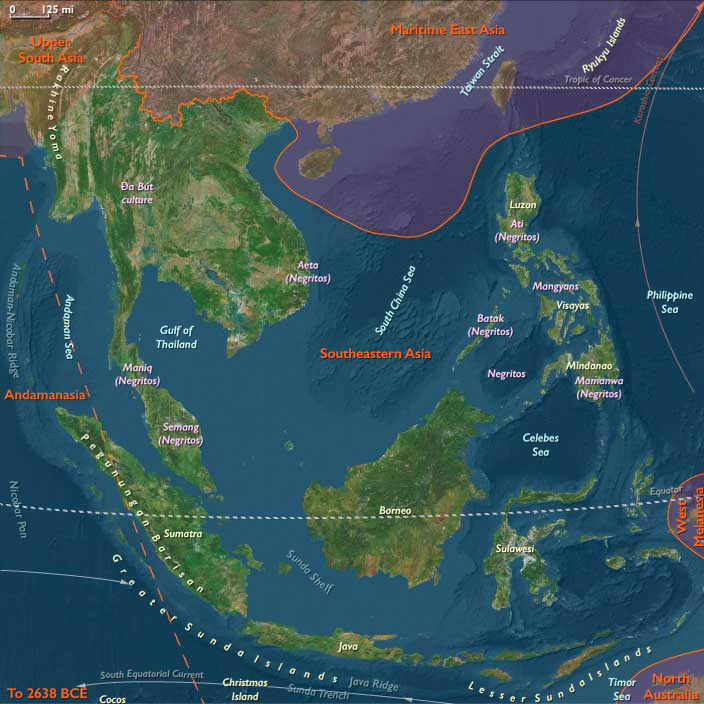
Southeastern Asia (49,293 – 28,578 BCE): Sundaland …
Years: 49293BCE - 28578BCE
Southeastern Asia (49,293 – 28,578 BCE): Sundaland Foragers, Island Crossings, and the First Rock Art
Geographic and Environmental Context
Southeastern Asia includes southern and eastern Myanmar, Thailand, Cambodia, Laos, Vietnam, the Malay Peninsula, Sumatra (excluding Aceh and its western islands), Java, Borneo, Sulawesi, the Philippines, and surrounding archipelagos (Banda, Molucca, Ceram, Halmahera, Sulu seas).
-
Anchors: the Irrawaddy, Chao Phraya, and Mekong basins; the Red River Delta; volcanic highlands of Java–Sumatra; Borneo’s riverine interiors; Sulawesi’s peninsulas; the Philippines’ Luzon–Visayas–Mindanao cores.
-
Sea level stood 50–120 meters lower than today, merging the Malay Peninsula, Sumatra, Java, and Borneo into a single mega-landmass—Sundaland—of broad river valleys, savannas, and coastal plains.
-
To the east, the deep-water gaps of Wallacea (Sulawesi, the Moluccas, the Bali–Timor arc, and the Philippines) remained islands, separated by swift channels (the Wallace Line) that demanded short open-sea crossings.
Climate and Environmental Shifts
-
The period spans late Pleistocene cool phases and interstadials, trending toward the onset of the Last Glacial Maximum near the end of the age.
-
Cooler–drier episodes expanded grassland mosaics on Sundaland, while interstadials rebounded forests and wetlands; monsoon strength fluctuated, shifting river courses and estuaries.
Societies and Political Developments
-
Populations consisted of small, highly mobile hunter–gatherer bands organized by kinship and seasonal partnership networks.
-
Group sizes typically ranged from a few families to larger seasonal congregations along rivers, lakes, and exposed coastal flats.
-
Leadership was situational (tracking, navigation, healing), with no enduring centralized authority.
Economy and Trade
-
Broad-spectrum foraging: large and medium game (e.g., deer, wild cattle, suids), riverine and lacustrine fishing, shellfish, turtles, mangrove resources, honey, fruits, and tubers.
-
On Wallacea and the Philippines, nearshore reefs and seagrass lagoons supported intensive coastal collecting and fishing; island forests yielded sago, nuts, and birds.
-
Inter-band exchange moved high-quality stone, shells, ocher, and worked bone/teeth ornaments along coastlines and river corridors.
Subsistence and Technology
-
Flaked stone toolkits (large flakes, blades, denticulates, scrapers) with early hafting for spears and knives; regional diversity reflected local raw materials (chert, chalcedony, volcanic glass).
-
Bone and shell tools (awls, fish gorges, barbed points) expanded fishing efficiency; fiber nets, traps, and weirs likely appeared along major waterways.
-
Controlled fire shaped edge habitats and eased travel; hide and bark-fiber cordage supported hafting and carrying slings.
-
Short pelagic crossings—probably on bamboo/dugout craft or lashed-raft platforms—linked Sundaland with Sulawesi, Banda–Moluccas, and the Philippines, sustaining an early island-hopping seamanship tradition.
Movement and Interaction Corridors
-
Sundaland river highways (paleo-Mekong, paleo-Mahakam, paleo-Kapuas, paleo-Brantas, etc.) funneled people and goods from interior hunting grounds to exposed continental-shelf coasts.
-
Wallacea crossings (Bali–Lombok, Sulawesi straits, Moluccan gaps) maintained east–west contact despite strong currents, carrying tools, pigments, and ideas.
-
Philippine routes (Luzon–Visayas–Mindanao, Sulu arc) linked deltaic estuaries to offshore reefs and islands.
Belief and Symbolism
-
Cave and rock art blossomed: hand stencils and animal figures in Sulawesi and Borneo date within this timespan, testifying to complex symbolic life.
-
Ocher use (body painting, binder for adhesives, and ritual marking) and personal ornaments (shell/teeth beads) signaled identity and inter-band alliances.
-
Hunting magic, ancestor beings, and water/rock spirits likely structured ritual calendars tied to monsoons, spawning runs, and herd migrations.
Adaptation and Resilience
-
Mobility + diversification minimized risk: bands shifted between forests, river wetlands, shelf coasts, and island reefs as climates oscillated.
-
Mixed terrestrial–aquatic diets buffered lean seasons; littoral “safety nets” (shellfish, reef fish) stabilized caloric intake.
-
Distributed knowledge networks (navigational wayfinding, water-source mapping, plant–animal lore) enhanced survival as landscapes transformed approaching the glacial maximum.
Long-Term Significance
By 28,578 BCE, Southeastern Asia’s peoples had forged Sundaland–Wallacea lifeways: expert foragers, early mariners, and celebrated rock artists. Their river–reef economy, short-hop seafaring, and symbolic traditions laid enduring foundations for later Holocene societies—from Angkor’s rice basins to the spice circuits of the Moluccas.
Topics
Commodoties
Subjects
Regions
Subregions
Years: 49293BCE - 28578BCE
Topics
Commodoties
Subjects
Regions
Subregions