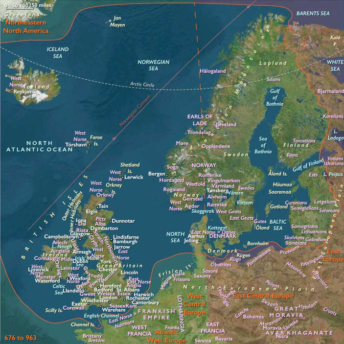
Vikings of the 800s and 900s bury …
Years: 892 - 903
Vikings of the 800s and 900s bury their important leaders in fully rigged ships beneath burial mounds, accompanied by a wealth of domestic utensils and funerary offerings.
The so-called Gokstad ship burial in southern Norway, dating to about 900, exemplifies Norse seagoing longships of the age.
Measuring more than seventy-five feet (twenty-three meters) long and seventeen feet (five and a quarter meters) wide, and built of oak and pine, with a heavy wooden keel and high prow and stern, its overlapping planks are nailed together and lashed to nineteen ribs and cross members.
Sixteen oar holes pierce each side of the hull; a corresponding thirty-two shields are mounted one over the next along the gunwales.
A single mast carries a huge square sail whose yard measures thirty-six feet (eleven meters) across.
An oar fixed at the aft end on the starboard side steers the ship.
Locations
Groups
Topics
Commodoties
Subjects
Regions
Subregions
Related Events
Filter results
Showing 10 events out of 66 total
South America (1540 – 1683 CE)
Empires of Silver and Sugar, Frontiers of Resistance
Geographic Definition of South America
The region of South America includes all lands south of the Isthmus of Panama: Brazil, Uruguay, Paraguay, northern Argentina and northern Chile, Bolivia, Peru, Ecuador (excluding the Cape lands), Colombia (excluding the Darién region), Venezuela, Guyana, Suriname, French Guiana, and, farther south, southern Chile, southern Argentina, Patagonia, Tierra del Fuego, the Falkland Islands (Islas Malvinas), and the Juan Fernández Islands.
Anchors spanned the Andes cordillera and Altiplano, the Amazon, Orinoco, and Magdalena river systems, the Venezuelan Llanos, Gran Chaco, Pampas, and Guiana Shield, extending south to the Araucanian Andes, the Patagonian steppe, and the Strait of Magellan.
From rainforest to desert, from ice-bound fjords to equatorial coasts, the continent entered its first great age under Iberian rule—an age of extractive empires, enslaved labor, and enduring Indigenous worlds beyond the reach of crown and cross.
Imperial Geography and Environmental Frontiers
By the mid-sixteenth century, two colonial powers divided the continent:
Spain, governing through the Viceroyalty of Peru (established 1542), ruled from Lima across the Andes to the silver mines of Potosí and the highland cities of Cuzco, Quito, and La Paz;
Portugal, through the State of Brazil (from 1549), commanded the Atlantic rim from Bahia and Pernambuco to Rio de Janeiro.
Between them stretched immense interior worlds—Amazonian forests, Chaco plains, Llanos, and southern pampas—where Indigenous confederations, runaway slaves, and missionary enclaves coexisted beyond direct imperial reach.
Farther south, Mapuche, Tehuelche, and Fuegian nations held their territories against repeated incursions, making the sub-Antarctic fringe the last unconquered frontier of Iberian America.
Climate and Environmental Shifts
The Little Ice Age defined the era’s physical rhythm.
-
Andes and Altiplano: Cooler temperatures and erratic frosts shortened harvests; El Niño floods devastated Peruvian coasts and fisheries.
-
Amazon and Orinoco: Alternating decades of deluge and drought altered navigation and field cycles.
-
Gran Chaco and Pampas: Droughts followed by torrential rains tested herders and farmers.
-
Southern Chile and Patagonia: Harsher winters and advancing glaciers limited crops but preserved pastoral abundance.
Despite climatic volatility, Indigenous and colonial systems adapted—terracing, irrigation, and crop rotation in the highlands; shifting cultivation and fisheries in the lowlands; and new livestock economies across the southern plains.
Subsistence and Settlement
Colonial and Indigenous societies intertwined yet remained distinct.
-
Andean Highlands: Spaniards imposed encomienda and mita labor drafts; Indigenous farmers sustained maize, potato, and quinoa cycles; and Potosí’s silver—extracted by Aymara and Quechua labor—underwrote imperial finance.
-
Pacific Coasts: Sugar, cotton, and vineyards flourished on coastal haciendas worked by enslaved Africans and Indigenous tenants.
-
Brazilian Coast: Sugar plantations in Bahia and Pernambuco dominated exports; African slavery expanded while Jesuit missions sought (and often failed) to protect Indigenous captives.
-
Southern Brazil and Paraguay: Cattle ranching spread over grasslands, creating the first gaucho frontiers; Jesuit reducciones organized Guaraní communities around churches, workshops, and communal fields.
-
Amazon and Guianas: Arawak, Tupí, and Carib societies persisted through horticulture, fishing, and flight from slavers; European forts and missions remained precarious outposts.
-
Southern Chile and Patagonia: The Mapuche maintained farming and trade south of the Bio-Bío; Tehuelche hunters roamed the steppe; Yaghan, Kawésqar, and Selk’nam peoples sustained maritime and inland lifeways untouched by permanent colonies.
Urban grids from Lima and Quito to Salvador and Santiago reflected imperial order, while vast hinterlands preserved pre-colonial autonomy.
Technology and Material Culture
Iberian technologies fused with Indigenous and African ingenuity:
-
Mining & metallurgy: Mercury amalgamation, mule-driven mills, and deep shafts redefined Andean landscapes.
-
Agriculture & transport: European plows, oxen, and terraces merged with Inca irrigation and storage systems.
-
Architecture: Rectilinear plazas, adobe houses, and stone churches rose through Indigenous labor; the Cusco School and Guaraní baroque sculpture merged local motifs with Christian iconography.
-
Lowland and frontier crafts: Dugout canoes, feather ornaments, and maroon ironwork embodied resistance and adaptation.
-
Southern frontier: The Mapuche’s adoption of the horse and iron weapons created a formidable cavalry culture that stalemated Spanish expansion for generations.
Movement and Interaction Corridors
South America’s circulation systems bound highlands, coasts, and oceans into a global network:
-
Qhapaq Ñan: The Inca road network became the backbone of colonial transport linking Lima, Potosí, and Quito.
-
Pacific & Atlantic routes: Silver, sugar, and hides moved through Callao, Cartagena, and Bahia to Seville and Lisbon.
-
Slave and mission networks: African captives entered via Cartagena, Salvador, and Lima; Jesuit and Franciscan missions spanned Paraguay, Bolivia, Amazonia, and Venezuela.
-
Indigenous & maroon corridors: Canoe and foot trails connected autonomous villages across the Amazon and Chaco, carrying goods, stories, and fugitives beyond imperial control.
-
Southern seas: The Strait of Magellan and Juan Fernández Islands became vital provisioning points for galleons and privateers.
Cultural and Symbolic Expressions
Catholic orthodoxy framed the public sphere, but syncretic traditions flourished beneath it.
-
Andes: Veneration of the Virgin intertwined with mountain deities (apus) and Pachamama; feast days mirrored ancient agricultural rituals.
-
Brazil & Guianas: Enslaved Africans and Indigenous peoples created hybrid faiths blending saints with orixás, drumming with procession.
-
Guaraní missions: Choirs sang polyphonic hymns in Indigenous languages; carved angels bore Guaraní faces.
-
Mapuche and Tehuelche southlands: Ritual feasts (ngillatun) and ancestral songs affirmed identity against foreign power.
-
Art & music: Andean painting schools, Jesuit orchestras, and African percussion enriched a continental baroque unlike any in Europe.
Environmental Adaptation and Resilience
Survival rested on ecological knowledge:
-
Highlands: Terraces, communal granaries, and mixed cropping cushioned climatic shocks.
-
Lowlands: Rotational gardens and foraging sustained food security; flight into forest refuges preserved freedom.
-
Missions: Combined maize, manioc, and European grains in sustainable polycultures.
-
Southern frontier: Mobility and cavalry warfare enabled Mapuche and Tehuelche resilience; canoe peoples of Tierra del Fuego maintained fire-lit cooperation in icy seas.
These strategies—diversified crops, mobile herds, and ritual reciprocity—ensured endurance across conquest and climate alike.
Technology and Power Shifts (Conflict Dynamics)
Imperial control expanded but never absolute:
-
Spanish consolidation: The Viceroyalty of Peru centralized administration; governors and clergy extended rule through coercion and conversion.
-
Portuguese assertion: The Governorate General of Brazil established Salvador as capital and fortified the coast, while bandeirantes pressed westward for slaves and gold.
-
Indigenous uprisings: From the Neo-Inca state at Vilcabamba (1537–1572) to Mapuche wars in Chile and Tupinambá revolts in Brazil, resistance persisted.
-
African maroons: Quilombos such as Palmares in northeast Brazil formed autonomous states blending African, Indigenous, and European traditions.
-
Imperial rivalry: Dutch and French privateers attacked Pernambuco and Maranhão; English corsairs raided the Pacific; Spanish–Portuguese boundaries blurred across the interior.
By the late seventeenth century, Iberian empires held the coasts and mines, but the heart of the continent—Amazon, Chaco, Patagonia—remained beyond their grasp.
Transition (to 1684 CE)
By 1683 CE, South America was both imperial citadel and frontier wilderness.
The Andes poured silver to Europe; Brazil’s plantations sustained the Atlantic economy. Jesuit missions, fortified cities, and royal roads proclaimed dominion—yet Indigenous nations, African maroons, and remote settlers governed vast interiors in their own ways.
From Potosí’s frozen summits to Bahia’s humid mills, from Lima’s plazas to Araucanía’s palisades, the continent bore the dual imprint of empire and resistance.
It entered the next age as a world of bound empires and unbroken peoples—its wealth feeding distant crowns, its endurance rooted in landscapes and cultures that empire could reshape but never erase.
South America Major (1540–1683 CE): Spanish Consolidation and Indigenous Resistance
Geographic & Environmental Context
The subregion of South America Major encompasses all lands north of the Río Negro, extending across the full continental span of Brazil, Uruguay, Paraguay, northern Argentina and northern Chile, Bolivia, Peru, Ecuador (excluding the Cape lands at the Isthmian boundary), Colombia (excluding the Darién region, which belongs to Isthmian America), Venezuela, Guyana, Suriname, and French Guiana.
Anchors include the Andes cordillera and Altiplano, the Amazon basin, the Orinoco and Magdalena river systems, the Venezuelan Llanos, the Gran Chaco, the Uruguayan Pampas, and the Guiana Shield. Bounded by Isthmian America to the north and Subcontinental South America to the south, this subregion forms the continental heartland of South America—linking the Pacific and Atlantic worlds through its intertwined highlands, forests, plains, and river systems.
Two great colonial systems arose upon earlier networks—the Spanish viceroyalty of Peru, radiating from Lima, Cuzco, and Potosí; and the Portuguese State of Brazil, anchored by Bahia, Pernambuco, and later Rio de Janeiro. Between them stretched vast interior frontiers, still largely autonomous in the mid-sixteenth century.
Climate & Environmental Shifts
The Little Ice Age continued to shape continental rhythms.
-
Andean highlands: Cooler winters and increased frost shortened crop seasons; El Niño cycles triggered floods on the Pacific coast and fisheries collapse.
-
Amazon and Orinoco basins: Rainfall fluctuated, producing alternating decades of flood and drought that affected lowland horticulture and river navigation.
-
Gran Chaco and Pampas: Drought cycles alternated with torrential rains, challenging pastoralists.
-
Brazilian coast: Humid tropical climates supported sugar plantations, while intermittent droughts struck the northeastern sertão.
Despite these extremes, both Indigenous and colonial economies demonstrated remarkable environmental resilience.
Subsistence & Settlement
Spanish Andes and Pacific Worlds
Following the Inca collapse, Spaniards imposed new institutions—encomienda grants, the rotational mita labor draft, and a network of colonial cities (Lima, Cuzco, Quito, La Paz). Potosí, founded in 1545 beneath Cerro Rico, became the world’s richest silver mine. Mercury amalgamation technology transformed extraction, drawing forced labor from the Altiplano and Aymara communities.
Highland and valley farmers continued to cultivate maize, potatoes, and quinoa; terraces, irrigation canals, and qollqas(storehouses) persisted. Spaniards introduced wheat, barley, sheep, and cattle, reordering land use but relying heavily on Indigenous techniques and labor. On the Pacific coast, sugar, cotton, and vineyards expanded around haciendas, supplied by enslaved African and Indigenous workers.
Portuguese Atlantic and Interior Brazil
Along Brazil’s Atlantic rim, sugarcane plantations flourished in Pernambuco and Bahia, powered by enslaved Africans and Indigenous captives. Inland, Tupí-Guaraní horticultural villages persisted, though many were absorbed into Jesuit missions (reduções). Farther south, cattle ranches spread across Rio Grande do Sul, Paraguay, and Uruguay, forming the first gaucho frontiers.
The Amazon remained largely autonomous: Arawak, Tupí, and Carib peoples maintained shifting agriculture, fishing, and hunting; Portuguese and Spanish expeditions after 1630 probed the great rivers but could not subdue the interior.
Northern and Eastern Frontiers
The Orinoco, Guiana Shield, and Venezuelan Llanos sustained dispersed horticultural and fishing communities. Along the Caribbean rim, colonial towns—Caracas, Cartagena, Santa Marta, Guayaquil—emerged as export nodes for cacao, hides, and indigo. Inland, Muisca descendants and Andean villagers adapted to tribute demands while preserving local councils and irrigation systems.
Technology & Material Culture
European mining, shipbuilding, and plantation machinery met Indigenous and African technologies, creating hybrid systems:
-
Mining: Shafts, wind-powered pumps, and amalgamation mills reconfigured Andean landscapes.
-
Architecture: Cities centered on rectilinear plazas with cathedrals, cabildos, and arcades built by Indigenous artisans; adobe, stone, and timber blended styles from Cuzco to Salvador.
-
Crafts and art: Andean weavers produced fine textiles for colonial markets; Jesuit and Guaraní artisans created sculpture, furniture, and music that fused baroque forms with Indigenous motifs.
-
Lowland tools: Dugout canoes, hammocks, and feather regalia continued in the Amazon; African ironworking and drumming traditions enriched plantation and port cultures.
Movement & Interaction Corridors
-
Andean road system (Qhapaq Ñan): Reused by Spanish administrators and mule trains to link Potosí, Cuzco, Lima, and Quito.
-
Pacific & Atlantic shipping: Silver and sugar moved via Callao and Seville, and from Bahia to Lisbon.
-
Mission networks: Jesuit and Franciscan routes extended through Paraguay, Bolivia, Amazonia, and Venezuela, creating chains of reducciones.
-
Slave and trade routes: Africans arrived through Cartagena, Lima, and Bahia; caravans and coastal fleets tied mines, estates, and ports.
-
Indigenous trade: Canoe networks on the Amazon, Orinoco, and Magdalena persisted, carrying pottery, salt, and fish beyond colonial reach.
Cultural & Symbolic Expressions
Catholicism dominated public life yet merged with older spiritual frameworks.
-
In the Andes, reverence for sacred mountains (apus) and earth spirits (Pachamama) blended with devotion to saints and the Virgin, yielding syncretic cults like the Señor de Qoyllur Rit’i.
-
In Brazil, African and Indigenous beliefs fused with Catholic ritual to form enduring hybrid traditions.
-
The Guaraní expressed spirituality through music, communal dance, and mission festivals, where baroque choirs sang in Indigenous languages.
-
Across forests and plains, shamans continued ayahuasca ceremonies, negotiating survival through spirit alliances.
Art, song, and ritual remained vehicles of endurance and resistance, embedding memory in colonial space.
Environmental Adaptation & Resilience
Despite forced labor and ecological upheaval, Indigenous and African-descended communities preserved adaptive strategies:
-
Highlands: Terraces and crop rotations buffered frost; communal granaries maintained security.
-
Lowlands: Shifting cultivation and foraging sustained autonomy; flight and resettlement were frequent defenses.
-
Frontiers: Maroon settlements of escaped Africans and Indigenous allies formed along Brazil’s interior and the Andean foothills.
-
Missions: Blended European crops with native foods—manioc, maize, bananas—creating self-sufficient enclaves.
These layered adaptations allowed cultural continuity beneath the structures of empire.
Technology & Power Shifts (Conflict Dynamics)
Spanish authority consolidated through the Viceroyalty of Peru (1542), governed from Lima, while Portugal asserted control over Brazil under the Governorate General (1549). Yet power was never absolute.
-
Indigenous uprisings: Rebellions erupted from Vilcabamba (Inca remnant, 1537–1572) to Tupinambá wars on Brazil’s coast and Guaraní resistance in the missions.
-
Frontier wars: Chaco and Amazon peoples raided colonial outposts; Mapuche uprisings farther south halted Spanish expansion for generations.
-
Imperial rivalries: Dutch and French corsairs struck Brazilian ports; Portugal’s bandeirantes pushed west for slaves and gold, violating Spanish borders despite the Treaty of Tordesillas.
-
Labor regimes: The mita, repartimiento, and Atlantic slavery bound millions into extractive economies, sustaining the silver-sugar circuit that underwrote Iberian wealth.
Transition (to 1684 CE)
By 1683 CE, South America Major had become the twin heart of Iberian empire: Potosí’s silver flowed through Lima to Seville, and Brazilian sugar enriched Lisbon and Antwerp. Yet beneath the imperial façade persisted vast zones of autonomy—the Amazonian interior, the Chaco, the Llanos, and the mission frontiers.
Indigenous and African communities adapted through migration, syncretism, and rebellion; maroon republics and highland ayllus endured beside mines and plantations. The continent’s landscapes bore the marks of empire—terraces reworked as estates, forests cleared for cane, rivers turned to silver channels—but its peoples preserved older rhythms of survival.
South America in 1683 stood as both imperial core and frontier world—a continent bound to Atlantic circuits yet still resonant with the resilience of its first nations.
All able-bodied "free" natives are required to devote one year of their labor to some public or private Spanish concern, be it constructing a church, road, or public building, or working in a textile mill.
Although mitayos are paid for their labor, the amount is extremely meager, often less than debts accumulated through purchases from their employer, thus requiring them to continue working, sometimes indefinitely, after their assigned period of service.
In this way, the mita system disintegrates into debt peonage.
Debts are commonly passed on to ensuing generations, in which cases the mita is, in effect, slavery.
Enslaved blacks number some sixty thousand by the end of the colonial period.
Spain's colonies in the New World are, legally, the personal patrimony of the king, and he holds absolute control over all matters in Ecuador.
Colonial administration at all levels is carried out in the name of the monarch.
The king's chief agency in Madrid is the Council of the Indies, which devotes most of its energies to formulating legislation designed to regulate virtually every aspect of colonial life.
The House of Trade, seated in Seville, is placed in charge of governing commerce between Spain and the colonies.
In America, the king's major administrative agents are the viceroyalty, the audiencia (court), and the municipal council (cabildo).
Between 1544 and 1563, Ecuador is an integral part of the Viceroyalty of Peru, having no administrative status independent of Lima.
It remains a part of the Viceroyalty of Peru until 1720, when it joins the newly created Viceroyalty of Nueva Granada; within the viceroyalty, however, Ecuador is awarded its own audiencia in 1563, allowing it to deal directly with Madrid on certain matters.
The Quito audiencia, which is both a court of justice and an advisory body to the viceroy, consists of a president and several judges (pidores).
The territory under the jurisdiction of Quito considerably exceeds that of present-day Ecuador, extending southward to the port of Paita in the north of present-day Peru, northward to the port of Buenaventura and the city of Cali in the south of present-day Colombia, and well out into the Amazon River Basin in the east.
Quito is also the site of the first (founded in 1547) and most important municipal council within the area comprising modern-day Ecuador. It consists of several councilmen (regidores) whose extensive responsibilities include the maintenance of public order and the distribution of land in the vicinity of the local community.
The borders of the audiencia (or kingdom as it is also known) of Quito are poorly defined, and a great deal of its territory remains either unexplored or untamed throughout much of the colonial era.
Only in the Sierra, and there only after a series of battles that rage throughout the mid-sixteenth century, will the native population be fully subjugated by the Spanish.
The jungle lowlands in both the Oriente and the coastal region of Esmeraldas are, in contrast, refuges for an estimated one-quarter of the total native population that remain recalcitrant and unconquered throughout most or all of the sixteenth and seventeenth centuries.
Despite Orellana's harrowing journey of discovery, the Oriente remains terra incognita to the Spanish until its settlement by Jesuit missionaries beginning in the mid-seventeenth century, and it will continue to be largely inaccessible throughout the remainder of the colonial period.
Native mitayos, who commonly work from dawn to dusk chained to their looms, provide the labor.
As appalling as are the preindustrial working conditions in the obrajes, most historians agree that they were more bearable than those found in the Peruvian mines at the time.
The hardships of working in the silver and mercury mines of Peru cost the lives of millions of native mitayos; Ecuador, in contrast, has only small deposits of gold and silver in its southern provinces of Cuenca and Loja, and these deposits are depleted by the end of the sixteenth century.
Its serrano economy is based, instead, on agriculture and textiles.
The relative autonomy of this coastal region nearest to Quito enhances the effect of the Andes in isolating the Ecuadorian Sierra from the rest of the world during most of the nearly three centuries of colonial rule.
Behind these barriers, a social system is established that is essentially a replica of the Spanish feudal system at the time of the conquest, with the peninsulares (Spanish-born persons residing in the New World) being the ruling, landed elite and the natives being the subject people who work the land.
Although a few towns, particularly Quito, Riobamba, and Cuenca, grow along with the administrative and Roman Catholic bureaucracies and the local textile industries, colonial Ecuador is essentially a rural society.
The most common form in which the Spanish occupy the land is the encomienda.
Settlers are granted land, along with its inhabitants and resources, in return for taking charge of defending the territory, spiritually indoctrinating the native population, and extracting the crown's annual tribute (payable half in gold, half in local products) from the encomienda's native population.
There are some five hundred encomiendas in Ecuador by the early seventeenth century.
Although many consist of quite sizable haciendas, they are generally much smaller than the estates commonly found elsewhere in South America.
A multitude of reforms and regulations does not prevent the encomienda from becoming a system of virtual slavery of the natives, estimated at about one-half the total Ecuadorian population, who live on them.
In 1589 the president of the audiencia recognizes that many Spaniards are accepting grants only to sell them and undertake urban occupations, and he stops distributing new lands to Spaniards; however, the institution of the encomienda will persist until nearly the end of the colonial period.
Land that is less desirable is never distributed, but rather is left to traditional native communities or simply remains open public land.
In the late sixteenth century, the estimated one-quarter of the total native population on such public lands is resettled into native towns called reducciones in order to facilitate the collection of the natives' tribute, their conversion to Christianity, and the exploitation, of their labor.
Guayaquil, despite being destroyed on several occasions by fire and incessantly plagued by either yellow fever or malaria, is a center of vigorous trade among the colonies, a trade that is technically illegal under the mercantilist philosophy of the contemporary Spanish rulers.
The guiding principle of mercantilism in the New World is that the colonies exist to serve the commercial needs of Spain.
Since trade among the colonies will not enrich Spain, it is banned.
In addition to textiles and other light manufactures from the Sierra, hardwoods and cocoa from coastal plantations are exported from the port of Guayaquil to points all over Spanish America, while a wide variety of items are imported, including foods and wines from Peru.
Guayaquil also becomes the largest shipbuilding center on the west coast of South America before the end of the colonial period.
Years: 892 - 903
Locations
Groups
Topics
Commodoties
Subjects
Regions
Subregions