Event
Interior East Africa (49,293–28,558 BCE): Late Pleistocene…
Interior East Africa (49,293–28,558 BCE): Late Pleistocene I — Rift Lakes, Highland Refugia, and the Changing Stone-Age Worlds of MIS 3
Geographic and Environmental Context
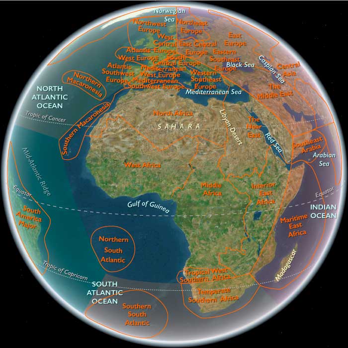
During Marine Isotope Stage 3, Interior East Africa extended from the Ethiopian and Eritrean highlands through the Upper Nile basin and the Rift Valley to the equatorial Great Lakes and the savanna woodlands of Tanzania, Zambia, northern Zimbabwe, northern Malawi, and northwestern Mozambique.
The subregion included volcanic plateaus, escarpments, river gorges, upland basins, Rift Valley lakes, equatorial highlands, great inland lake systems, floodplains, wetlands, savannas, woodlands, and southern plateaus.
These environments did not form one uniform landscape. Instead, Interior East Africa consisted of a shifting mosaic in which lakes, grasslands, forests, wetlands, and highland vegetation repeatedly expanded and contracted as rainfall and temperature changed.
The Rift Valley, Ethiopian Highlands, Upper Nile, Great Lakes, and southern plateau systems provided the principal geographic frameworks within which human populations moved and adapted.
Climate and Environmental Shifts
MIS 3 brought repeated alternations between cooler, drier intervals and relatively warmer or wetter conditions.
In the Ethiopian Highlands, changing temperature and rainfall altered the extent of grassland, woodland, and montane vegetation. Springs, rivers, upland basins, and highland wetlands nevertheless provided persistent concentrations of water and biological resources.
Southward through Kenya and Tanzania, Rift Valley lakes such as Turkana, Nakuru, Naivasha, Natron, and Eyasivaried substantially in extent and salinity.
During wetter phases, shallow water and marsh spread across low basins and supported productive grassland margins. During drier phases, retreating shorelines exposed broad flats and concentrated animals and people around springs, rivers, and surviving lake margins.
The Great Lakes farther west and south also changed markedly. Lake Victoria, Tanganyika, Kivu, and neighboring basins rose and fell, alternately exposing and inundating littoral plains and reorganizing adjacent forests, grasslands, and wetlands.
In the Upper Nile basin, floodplains, marshes, channels, and seasonally wet grasslands expanded during wetter intervals and contracted when rainfall declined.
The defining climatic pattern was therefore repeated hydrological reorganization across a region in which access to water structured both ecology and human settlement.
Human Presence
Human populations were deeply established across Interior East Africa before the opening of this eon.
The history of MIS 3 in the region was therefore one of continuity, diversification, and changing regional traditions rather than first colonization.
Communities occupied rockshelters, highland basins, river margins, lake shores, savannas, woodland, plateau environments, and wetland margins.
Settlement remained mobile and recurrent rather than permanent.
Population distribution changed with rainfall, lake levels, vegetation, and animal movements. During dry phases, people concentrated more strongly around dependable water, while wetter intervals opened broader lowland and savanna corridors.
Interior East Africa was thus a securely inhabited but highly dynamic human landscape.
Rift Lakes and Highland Refugia
The Ethiopian Highlands formed one of the region’s most distinctive ecological worlds.
Volcanic plateaus, escarpments, river gorges, and upland basins created cool environments above surrounding lowlands. Springs, rivers, and wetlands could preserve favorable conditions even when lower landscapes became drier.
Farther south, Rift Valley basins repeatedly alternated between expanded lakes and more fragmented water systems.
These shifts strongly affected human settlement.
Lake margins concentrated fish, plants, birds, grazing animals, and freshwater. When lakes contracted, surviving springs and channels became especially important refugia.
Highlands could provide cooler, more reliable environments during dry phases, while lowland corridors became more productive during wetter intervals.
The resulting pattern was not simple retreat into refugia but continual movement among highland, basin, lake, and savanna environments.
Great Lakes and Upper Nile Systems
The Great Lakes formed another major ecological and human framework.
Changing lake levels repeatedly altered the extent of littoral plains, wetlands, grasslands, and forest margins.
Fish and other aquatic resources could be locally important, while adjacent terrestrial habitats supported game and plant foods.
The Upper Nile formed a similarly persistent corridor through seasonally variable country.
Floodplains, marshes, and channels could contract during dry intervals but remained critical concentrations of water and biological productivity.
These aquatic systems provided both resources and routes, linking otherwise distinct ecological zones.
Subsistence and Settlement
Human populations lived by hunting, gathering, and locally exploiting aquatic resources.
Open grasslands supported antelope and other terrestrial game.
Woodland supplied fruits, nuts, tubers, roots, and smaller animals.
Lakes and rivers offered fish, mollusks, waterbirds, and other aquatic foods where locally available.
Wetlands and floodplains added plants, fish, birds, and concentrated terrestrial game.
No single economic pattern characterized the entire region.
Communities returned repeatedly to rockshelters, springs, lake margins, river corridors, and upland basins, but permanent settlements did not develop.
Broad diets and flexible mobility allowed people to respond to continual environmental rearrangement.
Technology and Material Culture
Stone-tool traditions were highly diverse.
Middle Stone Age technologies persisted across much of Interior East Africa during the opening millennia of the eon, including prepared-core methods, points, and flake tools.
Over time, some archaeological sequences record increasing use of blades, bladelets, backed pieces, and other small implements associated with emerging Later Stone Age traditions.
These changes did not occur everywhere at once.
At Mumba Rockshelter near Lake Eyasi, Middle Stone Age assemblages continued into MIS 3 while younger deposits contained increasingly microlithic technologies.
At Kisese II in Tanzania, prepared-core methods, bladelets, and backed pieces occurred within a long sequence extending through much of the eon.
Enkapune ya Muto in the Kenyan highlands likewise preserves early Later Stone Age industries by the later part of MIS 3.
The strongest regional pattern was therefore technological overlap and diversification rather than one uniform replacement.
Organic technologies were also central to everyday life.
Wooden implements, digging sticks, fibers, hides, carrying devices, and other perishable materials complemented stone tools in hunting, plant gathering, food processing, shelter, and transport.
Because such materials rarely survive, stone artifacts provide only a partial picture of technological life.
Movement and Connectivity
Mobility remained fundamental throughout the eon.
Communities moved among rockshelters, river margins, lake shores, springs, upland basins, woodland, and savanna according to changing water and food availability.
The Rift Valley acted as a major north–south structure linking basins and highlands.
The Ethiopian Highlands connected upland refugia with surrounding lowlands, while the Upper Nile linked floodplain and interior environments.
The Great Lakes created broad aquatic and littoral corridors, and southern plateau and river systems linked Tanzania with Zambia, Malawi, Zimbabwe, and northwestern Mozambique.
Connectivity expanded and contracted with climate.
Wetter phases opened broader grassland and woodland routes, while drier intervals concentrated movement around highlands, rivers, lakes, and dependable springs.
Cultural and Symbolic Expressions
Personal ornamentation entered the archaeological record in some parts of the region during MIS 3.
Ostrich-eggshell beads are known from several East African sites, including contexts in Kenya and Tanzania.
At some localities, red ochre was repeatedly collected and worked.
These objects indicate forms of personal display, social signaling, and symbolic expression accompanying technological change.
Their occurrence varied considerably between communities and environments and should not be treated as one uniform regional cultural package.
Much symbolic and social life probably also depended on perishable materials, body decoration, clothing, music, ritual, and persistent use of particular places.
Environmental Adaptation and Resilience
Human resilience depended on flexibility across a highly variable ecological mosaic.
Highlands provided dependable water and cooler habitats during some dry periods.
Rivers, wetlands, and surviving lake margins acted as refugia when surrounding landscapes became less productive.
Wetter intervals reopened broad lowland corridors and expanded grassland, woodland, and aquatic habitats.
Farther south, woodland, savanna, plateau, river valley, and lake-margin environments offered complementary resource zones.
Fire affected vegetation through both lightning and human activity. Around repeatedly used places, deliberate burning may sometimes have altered grass or scrub locally, although rainfall, soils, herbivores, and climatic fluctuation remained the dominant forces shaping regional vegetation.
Animals likewise shifted their ranges as habitats changed. Herds concentrated around surviving water during dry intervals and dispersed more widely during wetter phases.
Human communities adjusted their own movements to these changing distributions.
Transition
By 28,558 BCE, Interior East Africa contained a deeply varied mosaic of human communities and environments.
Middle Stone Age technologies persisted in many places while Later Stone Age methods became increasingly visible in others, and personal ornaments such as ostrich-eggshell beads formed part of the archaeological record in some areas.
Across the Rift, Ethiopian Highlands, Upper Nile, Great Lakes, and southern savannas, mobile hunter-gatherers continued to adjust their movements, subsistence, and technologies to changing lakes, grasslands, forests, wetlands, and highland refugia.
Cooler and generally drier conditions were becoming more prominent in parts of the region, but ecological change remained highly uneven rather than uniform.
At the close of Late Pleistocene I, Interior East Africa was therefore one of Africa’s most climatically and ecologically variable human landscapes—deeply inhabited, technologically diverse, and defined above all by the flexibility with which communities moved among water, highland, savanna, forest, and lake systems.

-
{# Image navigates to the detail page; the magnifying-glass chip is the only Fancybox lightbox trigger (kept a separate sibling — anchors can't nest). #}
 The Middle of The Earth
World
-
{# Image navigates to the detail page; the magnifying-glass chip is the only Fancybox lightbox trigger (kept a separate sibling — anchors can't nest). #}
 East Africa
Region
-
{# Image navigates to the detail page; the magnifying-glass chip is the only Fancybox lightbox trigger (kept a separate sibling — anchors can't nest). #}
 Interior East Africa
Subregion