Southeast Europe (7,821 – 6,094 BCE): Early…
7821 BCE to 6094 BCE
Southeast Europe (7,821 – 6,094 BCE): Early Holocene — Rivers, Shores, and the Memory of Water
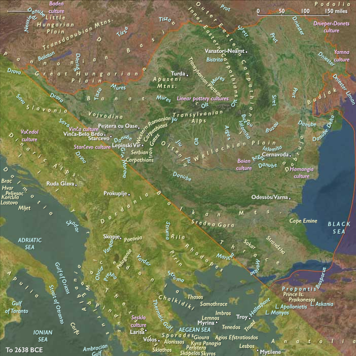
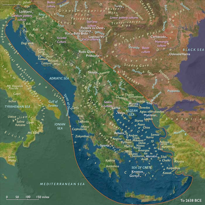
Geographic & Environmental Context
During the Early Holocene, Southeast Europe—a bridge between the Aegean, Danube, and Carpathian worlds—entered an age of waterborne abundance.
Postglacial sea rise transformed former plains into lagoons and archipelagos, while the Danube corridor, from the Iron Gates gorge to the Lower Moesian plains, became the central spine of cultural development.
Two distinct yet connected spheres emerged:
-
Eastern Southeast Europe, encompassing the Lower Danube, Thrace, and Dobruja, where rivers, marshes, and gorges fostered semi-sedentary riverine villages.
-
Western Southeast Europe, spanning the Adriatic archipelagos, Ionian shores, and Balkan upland basins, where coastal and riverine foragers clustered around estuaries, lakes, and inland valleys.
Together they formed a continent of waterways, where rivers and coasts were both home and highway.
Climate & Environmental Shifts
The Holocene thermal optimum brought warm, moist, and stable conditions to the Balkans.
-
Rivers—Danube, Sava, Drava, Maritsa, and Vardar—ran fuller but steadier, cutting deep valleys and spreading fertile alluvium.
-
Floodplain forests of oak, elm, hazel, and linden reached their postglacial maximum.
-
Lagoons and estuaries along the Adriatic and Aegean stabilized, producing dense fisheries and shell beds.
This equilibrium encouraged semi-permanent settlement, the accumulation of storage, and the beginnings of architectural planning.
Subsistence & Settlement
Southeast Europe’s lifeways revolved around the river, lagoon, and forest margin, forming the heart of the Mesolithic–Neolithic transition:
-
Eastern Southeast Europe (Lower Danube–Iron Gates–Thrace):
Along the Iron Gates gorge (sites like Lepenski Vir, Vlasac, Padina), communities built trapezoidal dwellings with stone-paved floors and structured hearths—the earliest architectural complexes north of the Aegean.
Subsistence focused on sturgeon and salmonid fisheries, supplemented by red deer, wild boar, nuts, and fruits.
Semi-sedentary hamlets persisted for centuries, forming the foundation for later Neolithic settlement in the Balkans. -
Western Southeast Europe (Adriatic–Ionian–Balkan uplands):
Coastal villages and shell-midden settlements along the Dalmatian and Ionian lagoons exploited fish, tunny, waterfowl, wild cereals, and game, while karst uplands supported seasonal hunting and nut collection.
Communities were partly mobile but ritually anchored to specific coves, rivers, and lakes.
Together, these groups formed a web of river and coastal societies—neighbors in ecology as much as geography.
Technology & Material Culture
Technological innovation paralleled the complexity of their environments:
-
Ground-stone adzes, chisels, and grinding querns for woodworking and seed processing.
-
Microlithic composites, bone harpoons, gaffs, and net sinkers for intensive fishing.
-
Early pottery appeared in the northern Danube plains and Thrace by the close of the epoch, used for cooking, storage, and feasting.
-
Canoes and rafts facilitated river and coastal mobility, expanding trade in shells, ochre, and flint.
-
At Lepenski Vir, stone sculptures depicting hybrid fish–human forms embodied both technological and symbolic mastery of the river’s abundance.
Movement & Interaction Corridors
Southeast Europe’s geography encouraged circulation and exchange:
-
The Danube corridor connected the Iron Gates to Moesia, Transylvania, and the Pannonian Basin, linking forest foragers with steppe-edge hunters and southern fisherfolk.
-
Portage routes branched from the Danube into the Tisza, Sava, and Drava basins, distributing innovations and materials northward.
-
Along the Adriatic, cabotage among the Dalmatian islands moved shell ornaments, obsidian, and exotic stones.
-
The Vardar–Axios valley carried marine goods and cultural influences from the Aegean deep into the Balkans.
Through these arteries flowed not just materials but ritual forms and ancestral stories, uniting river and sea cultures into a shared symbolic world.
Cultural & Symbolic Expressions
The Early Holocene Balkans were alive with ritual landscapes centered on water:
-
At Lepenski Vir, house-shrines, formal cemeteries, and anthropomorphic stone sculptures defined a ritual topography tied to the river’s cycles.
-
In Adriatic coves, shell-heap feasts and shoreline burials with ornaments celebrated lineage and the returning tides.
-
Shrine stones and hearths in both subregions marked continuity between generations, binding community identity to place.
Water was not only subsistence—it was the axis of belief and belonging.
Environmental Adaptation & Resilience
Resilience in these communities came through storage, diversification, and ritual memory:
-
Dried and smoked fish oils, nuts, and stored grain seeds stabilized food supplies across flood cycles.
-
Seasonal foraging rounds—from river to upland grove, coast to marsh—reduced environmental risk.
-
House-centered ritual reinforced social cohesion, ensuring collective response to unpredictable events.
By embedding economy and cosmology in the same places, they created landscapes of permanence within mobility.
Long-Term Significance
By 6,094 BCE, Southeast Europe had become a mature Mesolithic heartland of the Old World.
The Iron Gates culture—architecturally, ritually, and economically advanced—stood as Europe’s first long-term riverine civilization, while Adriatic and Aegean shore settlements refined broad-spectrum economies that would feed directly into Neolithic transitions.
The enduring legacy of this epoch was a cultural ecology of rivers and coasts: communities bound to water, sustained by its bounty, and preadapted for the farming horizons soon to sweep from Anatolia and the Aegean into the European mainland.
Topics
Commodities
Subjects
Regions