Fully advanced humans, sometimes referred to as…
25101 BCE to 23374 BCE
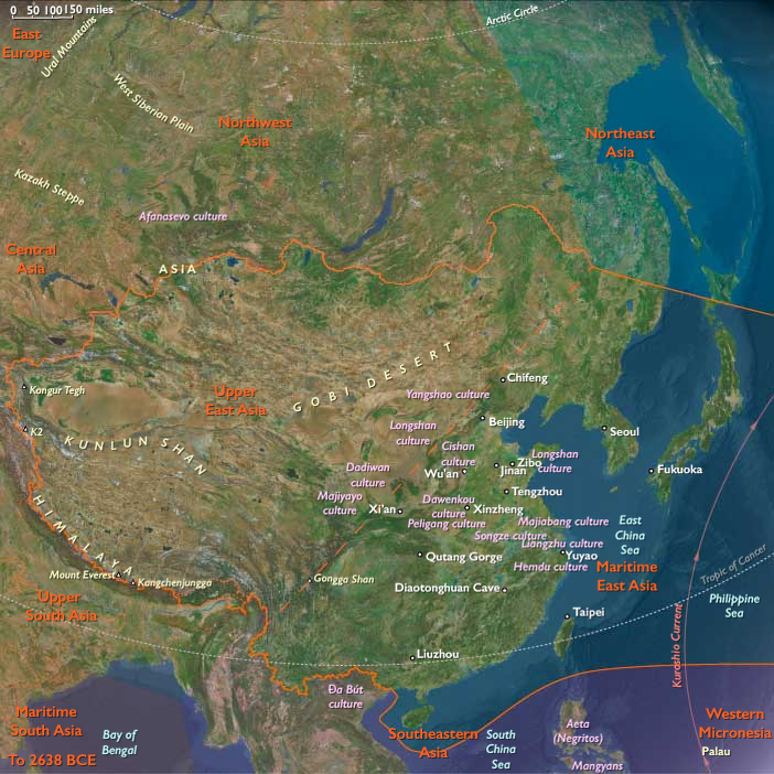
Fully advanced humans, sometimes referred to as Upper Cave people, hunt, fish, and produce shell and bone artifacts near Beijing (Peking) by about 25,000 BCE.
Commodities
Subjects
Regions
East Asia
View →Subregions
Maritime East Asia
View →Related Events
No active filters.
Showing 10 events out of 69508 total
The Emergence of Fiber Crafting and Early Textile Technology (c. 26,000 Years Ago)
By approximately 26,000 years ago, women across different regions had begun using natural fibers to create a variety of essential tools and garments, marking a significant advancement in prehistoric textile and tool-making technologies. This innovation not only enhanced daily life and survival strategies but also reflected the growing ingenuity and adaptability of early human societies.
Fiber Crafting and Its Applications
- Baby Carriers – Early humans likely fashioned fiber slings or wraps to carry infants, allowing for greater mobility while ensuring the care and safety of young children.
- Clothing – Fibers were woven or knotted into basic garments, complementing the use of animal hides for protection against harsh climates.
- Bags and Baskets – Crafted for gathering, storing, and transporting food and tools, these items indicate an increased reliance on plant-based resources.
- Nets and Cordage – Some of the earliest evidence of fishing and trapping technology comes from the creation of fiber nets, which allowed for more efficient food procurement.
Significance of Fiber Crafting
- Represented an early form of textile production, laying the foundation for later innovations in weaving and spinning.
- Allowed for greater economic and social organization, as fiber crafting likely became a specialized skill passed down through generations.
- Expanded the role of plant materials in human survival, alongside hunting and stone tool-making.
The ability to manipulate and utilize plant fibers for diverse purposes demonstrated the ingenuity of Upper Paleolithic societies, highlighting their technological advancements and evolving cultural complexity. These innovations in textile and tool-making would continue to shape human societies well into the Neolithic era and beyond.
One typical artifact of the industry, once considered diagnostic, is a small pointed blade with a straight blunt back, known as the Gravette point.
These are used to hunt big game including bison, horse, reindeer and mammoth.
Gravettians also use nets to hunt small game.
The origins of the Gravettian people are not clear; they seem to appear simultaneously all over Europe.
The Ends of the Earth, one twelfth of the Earth’s surface, is bordered by the South Atlantic and South Pacific Oceans and includes Subcontinental South America, the Chonos Archipelago, Chiloé Island, Tierra del Fuego, the Falkland Islands, the remote Juan Fernández Islands (notably home to the marooned sailor Alexander Selkirk from 1704 to 1709, an experience thought to have inspired Daniel Defoe’s Robinson Crusoe), the even more remote Easter Island, and West Antarctica—the portion of Antarctica that lies within the Western Hemisphere and includes the Antarctic Peninsula.
Easter Island, culturally Polynesian yet governed by Chile, is among the most isolated inhabited islands in the world, positioned in the eastern South Pacific Ocean at the northwestern edge of The Ends of the Earth, along with the equally remote Pitcairn Islands.
The southeastern and southwestern boundaries divide West Antarctica from the much larger East Antarctica.
The northeastern boundary follows the approximate courses of the Colorado and Barrancas Rivers, which flow from the Andes to the Atlantic Ocean and are traditionally recognized as the northern limit of Argentine Patagonia.
For Chilean Patagonia, most geographers and historians identify its northern boundary at the Huincul Fault in the Araucanía Region.
HistoryAtlas contains 153 entries for The Ends of the Earths from the Upper Paleolithic period to 1899.
Narrow results by searching for a word or phrase or select from one or more of a dozen filters.
The Last Glacial Maximum (LGM) refers to the time of maximum extent of the ice sheets during the last glacial period, between twenty-six thousand five hundred and nineteen thousand to twenty thousand years ago.
The Younger Dryas will follow the Last Glacial Maximum.
Ice sheets cover the whole of Iceland and all but the southern extremity of the British Isles.
This ice extends northward to cover Svalbard and Franz Josef Land and eastward to occupy the northern half of the West Siberian Plain, ending at the Taymyr Peninsula, and damming the Ob and Yenisei rivers forming a West Siberian Glacial Lake.
Northern Europe is largely covered, the southern boundary passing through Germany and Poland, but not quite joined to the British ice sheet.
Permafrost covers Europe south of the ice sheet down to present-day Szeged and Asia down to Beijing.
The ice covers essentially all of Canada and extends roughly to the Missouri and Ohio Rivers, and eastward to New York City.