The Near East (49,293 – 28,578 BCE)…
49293 BCE to 28578 BCE
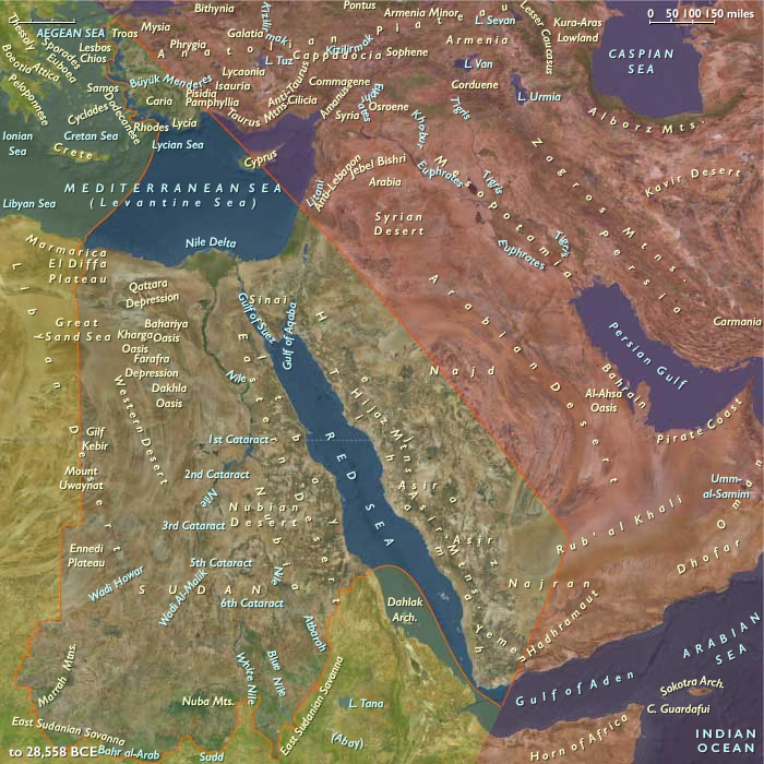
The Near East (49,293 – 28,578 BCE) Upper Pleistocene I — Nile Refugia, Levantine Corridors, and Aegean Shelves
Geographic and Environmental Context
The Near East includes Egypt, Sudan, Israel, most of Jordan, western Saudi Arabia, western Yemen, southwestern Cyprus, and western Turkey (Aeolis, Ionia, Doris, Lydia, Caria, Lycia, Troas) plus Tyre (extreme SW Lebanon).-
Anchors: the Nile Valley and Delta; Sinai–Negev–Arabah; the southern Levant (with Tyre as the sole Levantine node in this subregion); Hejaz–Asir–Tihāma on the Red Sea; Yemen’s western uplands/coast; southwestern Cyprus; western Anatolian littoral (Smyrna–Ephesus–Miletus–Halicarnassus–Xanthos; Troad).
Climate & Environment
-
LGM: hyper-arid Sahara/Sinai, but Nile retained perennial flow from equatorial rains; Red Sea and Aegean sea levels ~100 m lower exposed shelves and islands.
Subsistence & Settlement
-
Foragers aggregated along Nile flood margins, delta levees, oases (Western Desert), and Levantine springs; seasonal use of Aegean Anatolian caves and capes.
Technology & Material Culture
-
Blade–microblade industries; bone points; tailored hide/plant-fiber clothing; ochre and bead ornaments.
Corridors
-
Nile corridor as demographic spine; Sinai–Negev pass to the Levant; Aegean–Anatolian capes and shelves as seasonal routes; Hejaz–Asir wadis sparsely used.
Symbolism
-
Ochred burials; engraved bone/stone; shrine-like hearth settings at favored flood-edge camps.
Adaptation
-
Riverline anchoring and oasis switching buffered aridity; coastal shelf foraging added stability.
Images

The Near East in the Upper Paleolithic
Commodities
Subjects
Regions
The Near and Middle East
View →Subregions