Event
Upper South Asia (1828–1971 CE): Colonial Infrastructure,…
Upper South Asia (1828–1971 CE): Colonial Infrastructure, National Mobilization, Partition, and Postcolonial States
Geographic Parameters
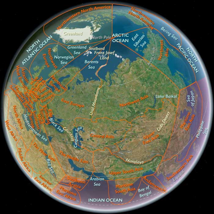
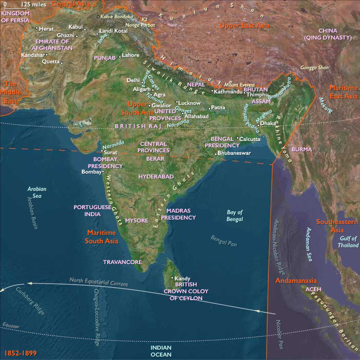
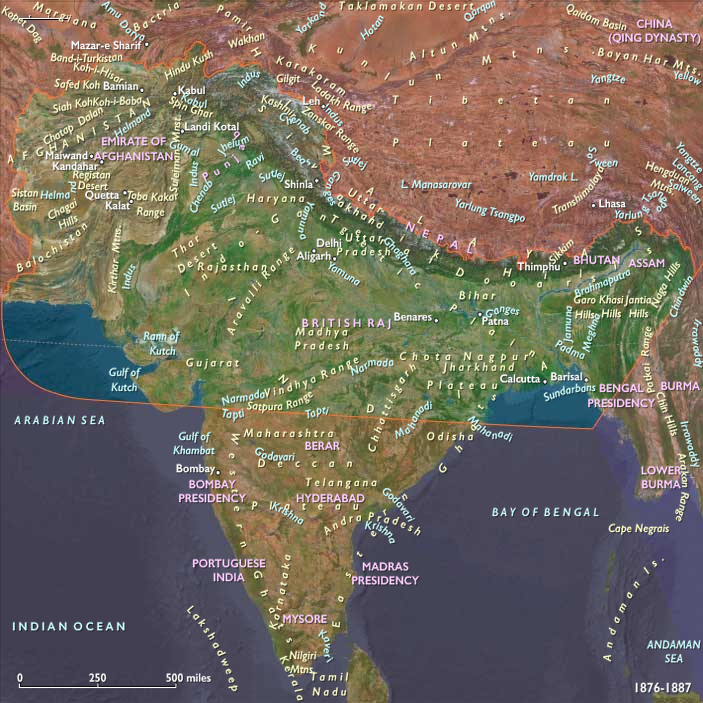
Upper South Asia extended from the Hindu Kush valleys of Afghanistan and the Khyber and Bolan approaches through Pakistan, Kashmir, Punjab, Rajasthan, and the northern Indian plains to Nepal, Bhutan, Bangladesh, and the whole North Eastern Region of India: Sikkim, Assam, Arunachal Pradesh, Meghalaya, Nagaland, Manipur, Mizoram, and Tripura. It also included northern Arakan/Rakhine and the Chindwin Valley in northwestern Myanmar.
Its defining environmental systems remained the Kabul–Gandhara mountain corridor, the Indus and Punjab plains, Rajasthan’s arid margins, the Ganges–Yamuna basin, the middle and lower Gangetic plains, the Bengal delta, the Brahmaputra Valley, the Himalayan foothills and high passes, the northeastern hill systems, and the Arakan–Chindwin routes connecting the Bay of Bengal with western mainland Southeast Asia.
These lands never became a single uniform colonial or national landscape. Railways, canals, roads, telegraphs, ports, cantonments, plantations, courts, dams, industrial centers, and national borders coordinated selected corridors, while villages, pastoral territories, mountain routes, wetlands, forests, religious neighborhoods, customary institutions, and locally managed agricultural systems continued beneath them.
Environmental Continuity
Agriculture remained the foundation of subsistence, taxation, employment, commerce, and national development. Wheat, barley, pulses, millet, cotton, sugarcane, oilseeds, and orchard crops supported Afghanistan, Pakistan, Punjab, Rajasthan, and the upper Gangetic districts. Rice dominated Bihar, Bengal, Assam, Manipur, Tripura, northern Arakan, the Kathmandu Valley, and other humid lowland and terrace systems.
Environmental conditions varied sharply across the subregion. Afghanistan and the northwest experienced recurring drought, severe winters, pasture stress, erosion, and unstable river flow. Punjab and the upper Gangetic plain faced drought, canal salinity, waterlogging, epidemic disease, and periodic crop failure. Bengal and the Brahmaputra basin remained vulnerable to cyclones, monsoon floods, river migration, embankment collapse, tidal surges, and the loss or creation of settlement land.
Himalayan communities contended with landslides, earthquakes, changing forest cover, glacial variation, and the disruption of seasonal routes. The northeastern hills and Chindwin basin experienced deforestation, plantation expansion, logging, wartime destruction, and the reorganization of shifting-cultivation landscapes.
Colonial and postcolonial governments increasingly attempted to engineer these environments through canals, embankments, drainage, forestry departments, plantations, reservoirs, dams, roads, and agricultural research. Such projects expanded production and state control in selected districts but also produced displacement, ecological simplification, salinity, erosion, forest loss, and conflicts over water and land.
The Consolidation of British Colonial Rule
The principal new organizing system of the age was the expansion of a rail-, canal-, telegraph-, military-, and revenue-linked colonial state across much of northern South Asia.
By 1828, the East India Company governed Bengal, Bihar, Delhi, much of the Gangetic plain, and newly acquired territories in Assam and Arakan. Its authority expanded through warfare, annexation, subsidiary alliances, treaties, revenue settlements, courts, surveys, and the subordination of regional rulers.
Company rule did not replace every existing institution. It depended on landlords, village headmen, bankers, merchants, clerks, soldiers, princely courts, religious authorities, local police, transport workers, and inherited Mughal and regional administrative practices.
Yet colonial power reorganized these systems around more regular taxation, codified property, military supply, export commerce, and territorial surveillance. The state increasingly sought to define who owned land, which forests could be used, where populations belonged, and which routes, markets, and frontiers could be controlled.
The Sikh Empire and British Annexation of Punjab
At the opening of the age, the Sikh Empire remained the dominant state in Punjab and Kashmir under Maharaja Ranjit Singh.
Its authority rested on revenue collection, fortified cities, cavalry, reformed infantry, artillery, diplomatic negotiation, and the incorporation of Sikh, Muslim, Hindu, Dogra, and European officers. Lahore served as its political center, while Amritsar remained central to Sikh religious life.
After Ranjit Singh’s death in 1839, succession struggles, court factionalism, and conflict between the army and ruling elites weakened the state. The Anglo-Sikh wars of 1845–1846 and 1848–1849 ended in British annexation of Punjab.
Colonial authorities retained and adapted parts of the Sikh military and administrative system. Sikh soldiers became important within British imperial armies, while Punjab was reorganized through districts, canals, roads, cantonments, agricultural settlements, and frontier policing.
Kashmir passed to the Dogra dynasty under the Treaty of Amritsar in 1846. Dogra rule extended over a culturally and environmentally diverse Himalayan state whose Muslim-majority valley, Hindu and Sikh districts, Buddhist regions, pastoral territories, and mountain routes remained unequally governed.
Afghanistan and the Anglo-Afghan Frontier
Afghanistan remained outside direct British rule, but it became central to imperial rivalry between Britain and Russia.
The First Anglo-Afghan War of 1839–1842 attempted to install a compliant ruler in Kabul. Occupation provoked resistance, and the retreat from Kabul ended in disaster for the British-led force and severe suffering for Afghan and South Asian soldiers, camp followers, and civilians.
The Second Anglo-Afghan War of 1878–1880 again brought invasion, occupation, treaty-making, and resistance. British forces withdrew from permanent control of the interior but secured influence over Afghan foreign relations.
Under Amir Abdur Rahman Khan, the Afghan state pursued stronger centralization through taxation, military reform, provincial governors, forced migration, suppression of revolts, and the subordination of regional communities. These policies increased state reach while producing violence, displacement, and ethnic and sectarian restructuring.
The Durand Line of 1893 divided Pashtun, Baloch, and other communities between Afghanistan and British India. It converted a zone of seasonal movement, tribute, and negotiated authority into a more explicitly bounded imperial frontier, though the line remained difficult to enforce and politically disputed.
The Third Anglo-Afghan War in 1919 allowed Afghanistan to regain control over its foreign affairs. Under Amanullah Khan and later rulers, the state pursued roads, schools, administration, military modernization, and limited industrial development while confronting conservative resistance, regional inequality, and the constraints of mountain geography.
The Revolt and War of 1857–1858
The uprising of 1857 began among Company soldiers but expanded into a broader conflict involving princes, landlords, peasants, townspeople, artisans, religious leaders, dispossessed elites, and local communities with differing aims.
Causes included military grievances, annexation, land and revenue policies, fears of religious interference, the erosion of aristocratic privileges, and wider resentment of Company authority.
Rebels seized Delhi and recognized the Mughal emperor Bahadur Shah Zafar as a symbolic sovereign. Fighting spread across parts of the Gangetic plain, Bundelkhand, Rohilkhand, Awadh, and central India.
The conflict included sieges, massacres, reprisals, executions, village destruction, confiscation, displacement, and widespread civilian suffering. British forces, loyalist rulers, Sikh and Gurkha soldiers, and other South Asian troops played decisive roles in suppressing the revolt.
After 1858, the British Crown replaced Company government. Mughal sovereignty ended, and colonial rule became more centralized, militarized, and racially segregated.
The British Raj and Administrative Consolidation
The British Raj governed through a combination of directly ruled provinces, princely states, frontier agencies, treaty relationships, and excluded or partially administered territories.
District officers, courts, police, censuses, surveys, land records, legal codes, public-works departments, and educational institutions extended state authority. Colonial administrations classified populations by caste, tribe, religion, language, occupation, and territory, often converting flexible identities into hardened official categories.
Princely states retained internal authority under British paramountcy. Their rulers maintained courts, armies of limited size, land systems, and ritual legitimacy while accepting imperial control over external relations and succession disputes.
Colonial governance remained uneven. Its strongest reach followed railways, canals, military roads, ports, district headquarters, plantations, mining districts, and productive agricultural zones. Mountain, forest, desert, and frontier societies continued to regulate many local affairs through customary institutions.
Railways, Telegraphs, and Colonial Corridors
Railways became the age’s most visible infrastructural system.
Lines connected Delhi, Lahore, Karachi, Calcutta, Bombay beyond the subregion, Banaras, Patna, Assam, and numerous district towns. Railways carried troops, grain, cotton, jute, tea, coal, timber, opium, mail, officials, pilgrims, and migrants.
The network strengthened military mobility and export extraction while also creating new markets, occupations, travel patterns, urban districts, and political connections. Railway construction required land acquisition, bridges, embankments, stations, workshops, imported machinery, and large labor forces.
Telegraph lines accelerated military and administrative communication. Postal systems, metalled roads, canals, and steam navigation further compressed distance along selected corridors.
These systems did not create uniform integration. Many villages remained distant from stations, and Himalayan, northeastern, Afghan, and forest regions continued to depend on footpaths, pack animals, ferries, and seasonal roads.
Canals and Agrarian Reorganization
Colonial engineering expanded irrigation on an unprecedented scale, especially in Punjab and the upper Gangetic plain.
The restoration and extension of the Ganges Canal and Punjab canal systems transformed selected dry districts into intensively cultivated agricultural zones. Canal colonies in Punjab settled cultivators, reorganized villages, increased wheat and cotton production, and tied new districts to railways and export markets.
These projects increased output and reduced drought risk in some areas, but they also produced unequal access, waterlogging, salinity, displacement, and stronger state control over land and water.
In Bengal, embankments, drainage projects, river surveys, and commercial agriculture reshaped deltaic landscapes without eliminating flood risk. In Assam and the northeast, plantation development converted forest and shifting-cultivation land into tea estates and administrative enclaves.
Colonial forestry restricted customary access to timber, grazing, hunting, and woodland products. Reserved forests and logging concessions brought ecological change and conflict with communities whose livelihoods depended on shared forest use.
Plantations, Commodities, and Industrial Change
Colonial commerce reorganized agriculture around exportable commodities.
Bengal and Bihar produced jute, indigo, opium, rice, sugar, and silk. Assam became a major tea-producing region through plantation investment, imported labor, coercive contracts, and strict labor discipline. Punjab supplied wheat, cotton, and military recruits. Arakan expanded rice exports through Sittwe, while the Chindwin basin supplied teak and forest products.
Indigo cultivation generated repeated conflict because planters and intermediaries forced cultivators into unfavorable contracts. The Indigo Revolt of 1859–1860 exposed the coercive foundations of plantation agriculture.
Opium production linked Bihar and the Gangetic plain to imperial trade with China. Jute mills around Calcutta and other industries created wage-labor districts while preserving extensive household and artisanal production.
Indian textiles faced pressure from machine-made British imports, though handloom weaving did not disappear. Weavers adapted through specialization, regional markets, new fibers, and household labor.
Industrialization remained geographically concentrated. Most people continued to live in rural communities dependent on agriculture, seasonal labor, craft work, pastoralism, and local trade.
Famine and Colonial Political Economy
Famines remained among the most destructive features of the age.
The famines of the nineteenth century emerged from combinations of drought, crop failure, livestock loss, disease, market integration, debt, taxation, inadequate relief, and official commitment to fiscal restraint and market orthodoxy.
Railways could move food, but they could also carry grain away from distressed districts toward more profitable markets. Access to food depended on purchasing power, employment, transport, social support, and state intervention rather than on aggregate supply alone.
The Bengal famine of 1943 resulted from wartime inflation, rice-supply disruption, crop losses, transport constraints, procurement, speculation, military priorities, and failures of government response. Millions died or were displaced.
Famine transformed households through land sales, debt, migration, orphaning, disease, and the collapse of craft and labor systems. Religious charity, kinship networks, local grain stores, migration, and informal credit offered limited protection but could not compensate for large-scale political failure.
Cities and Colonial Urbanism
Calcutta became the principal imperial and commercial metropolis of eastern South Asia. Delhi, Lahore, Karachi, Dhaka, Patna, Banaras, Peshawar, Quetta, Kabul, Srinagar, Kathmandu, and other centers also expanded.
Colonial cities contained government districts, cantonments, railway yards, docks, courts, universities, mills, warehouses, municipal works, European quarters, bazaars, religious neighborhoods, labor settlements, and surrounding villages.
Urban growth was spatially unequal. Planned civic and military districts often stood beside overcrowded neighborhoods lacking sanitation, secure housing, or reliable water.
Delhi regained imperial prominence when the British transferred their Indian capital from Calcutta in 1911. The construction of New Delhi created a monumental administrative district physically and socially separated from much of the older city.
Urban landscapes remained culturally plural. Mosques, temples, gurdwaras, monasteries, churches, shrines, printing presses, schools, workshops, and neighborhood associations continued to organize daily life.
Religious Reform and New Public Spheres
The nineteenth and early twentieth centuries brought wide-ranging religious and social reform.
The Brahmo Samaj, Arya Samaj, Islamic reform movements, Sikh revival organizations, Buddhist reformers, Christian missions, caste associations, and regional religious institutions used print, schools, public debate, pilgrimage, and voluntary societies to reshape community life.
Sir Syed Ahmad Khan and the Aligarh movement promoted modern education among Muslims and founded the Muhammadan Anglo-Oriental College in 1875. The institution later became Aligarh Muslim University.
Sikh reformers reorganized gurdwara administration and promoted a more clearly bounded communal identity. Hindu reformers debated caste, widow remarriage, education, religious authority, and the relationship between scripture and modernity.
Missionaries established schools, clinics, printing presses, and churches, especially in parts of Northeast India and the Himalayan borderlands. Conversion sometimes provided access to literacy and institutional support but could also disrupt customary authority and intensify communal boundaries.
Religious reform created new opportunities for education and public participation while also hardening distinctions that colonial classification and electoral policy increasingly treated as political categories.
Education, Print, and Political Association
Universities, colleges, vernacular schools, newspapers, literary societies, and printing presses created new political publics.
Western-educated professionals, lawyers, teachers, clerks, merchants, journalists, reformers, students, and religious leaders debated representation, social reform, economic policy, and imperial rule.
The Indian National Congress, founded in 1885, initially pursued constitutional reform and greater Indian participation in administration. It later became a mass nationalist organization encompassing moderates, radicals, socialists, trade unionists, peasant organizers, and advocates of nonviolent resistance.
The All-India Muslim League, founded in 1906, initially sought safeguards for Muslim political representation. Its goals evolved amid constitutional change, provincial politics, communal tensions, and debates over federalism and sovereignty.
Other organizations represented Sikh, caste, tribal, regional, linguistic, labor, peasant, revolutionary, and princely interests. Nationalism therefore developed through multiple and sometimes incompatible political programs.
Mass Nationalism and Civil Disobedience
Under Mohandas Gandhi, anticolonial politics became increasingly mass-based.
The Non-Cooperation Movement, Civil Disobedience Movement, Salt March, and Quit India Movement mobilized peasants, workers, merchants, students, women, religious communities, and local leaders through boycotts, strikes, marches, refusal of taxes, and rejection of colonial institutions.
Nonviolence served as both ethical discipline and political strategy, but nationalist mobilization also existed alongside revolutionary violence, peasant uprisings, labor conflict, communal riots, military mutiny, and armed resistance.
Subhas Chandra Bose and the Indian National Army pursued military struggle against British rule during the Second World War with Japanese support. Their campaigns intersected directly with the Burma and northeastern fronts.
Women participated in nationalist organizations, protests, underground networks, education, relief, and political writing, though leadership structures remained heavily male-dominated.
Afghanistan between Reform and Neutrality
Afghanistan regained full control over foreign affairs after the Third Anglo-Afghan War in 1919.
Amanullah Khan attempted rapid reform through schools, legal change, administrative centralization, infrastructure, altered dress and gender policies, and expanded diplomatic relations. Resistance from tribal, religious, and regional groups contributed to his fall in 1929.
Subsequent governments pursued more cautious modernization. Roads, schools, ministries, military institutions, limited industry, irrigation, and foreign assistance expanded gradually.
Afghanistan remained formally neutral during the Second World War and later sought aid from competing Cold War powers. Kabul and selected provincial centers modernized, while much of the country remained dependent on village agriculture, pastoralism, caravan movement, and customary authority.
Political centralization remained uneven and often coercive. Regional, ethnic, tribal, and religious communities retained substantial local influence.
Nepal under the Ranas and the Monarchy
Nepal remained formally independent but closely connected to British India.
The Rana oligarchy, established in 1846, controlled the government while preserving the Shah monarchy as a source of legitimacy. Rana rulers limited political participation, monopolized high office, and maintained close relations with Britain.
Gurkha soldiers served throughout the British Empire, and remittances and military recruitment tied Nepalese households to imperial networks.
The state expanded roads, palaces, schools, administration, and limited public works, but modernization remained concentrated in Kathmandu and selected corridors. Most communities relied on terrace agriculture, forest use, pastoralism, craft production, and seasonal labor.
The Rana system ended in 1951. Nepal then entered a contested period of monarchy, party politics, constitutional experimentation, foreign aid, road construction, and state expansion.
Bhutan and Controlled Modernization
Bhutan remained independent under the Wangchuck dynasty, established in 1907.
The monarchy consolidated authority through the existing dzong system, monastic institutions, regional administration, and negotiated relations with Britain and later India.
The Treaty of Punakha in 1910 increased British influence over Bhutan’s external affairs while preserving internal autonomy. After Indian independence, Bhutan developed a close relationship with India through the 1949 Treaty of Friendship.
Modernization remained deliberately gradual. Roads, schools, clinics, communications, and administrative institutions expanded mainly after the 1950s and 1960s.
Village agriculture, pastoralism, forest use, monastic life, seasonal festivals, and local authority remained central to Bhutanese society.
Northeast India under Colonial Rule
British authority expanded unevenly across Assam, Meghalaya, Nagaland, Manipur, Mizoram, Tripura, Arunachal Pradesh, and adjoining hill districts.
Tea plantations, oil extraction, coal mining, railways, roads, military posts, missionary schools, frontier agencies, and district headquarters transformed selected corridors.
Colonial governments often classified hill districts as excluded, partially excluded, tribal, or frontier territories. These policies limited some forms of outside settlement while also isolating communities from representative institutions and subjecting them to punitive expeditions, taxation, labor demands, and administrative boundaries.
Missionary activity contributed to literacy, new religious identities, educational networks, and political organization in several hill societies.
Valley and hill relations remained shaped by trade, land use, migration, tribute, labor recruitment, and competing claims to political autonomy. Colonial boundaries frequently divided related peoples or placed distinct communities within shared administrative units.
Arakan, the Chindwin, and Colonial Burma
Arakan and the Chindwin Valley became part of British Burma.
Sittwe, formerly Akyab, developed into a major rice-exporting port. Embankments, mills, shipping, credit, and labor migration expanded commercial agriculture in Arakan.
Migration from Bengal increased under colonial rule, creating new agricultural settlements and labor networks while intensifying competition over land, citizenship, and communal identity.
The Chindwin became an important transport route for teak, forest goods, petroleum from adjoining regions, military supplies, and inland commerce. Logging concessions and colonial forestry transformed woodland ecology and customary access.
Arakanese Buddhists, Rohingya and other Muslim communities, Chin peoples, Burman settlers, and numerous local groups experienced colonial rule differently. Administrative categories, labor migration, land policy, and later war sharpened tensions without reducing the region to a simple two-community conflict.
The Second World War
The Second World War transformed eastern Upper South Asia into a major military frontier.
Japanese forces conquered Burma in 1942 and advanced toward India. The Arakan coast, Chindwin Valley, Manipur, Nagaland, and Assam became crucial theaters of combat, supply, evacuation, and military construction.
The battles of Imphal and Kohima in 1944 halted the Japanese advance. Fighting involved British, Indian, African, Chinese, American, Japanese, Burmese, and Indian National Army forces.
Roads, airfields, pipelines, depots, hospitals, railways, and military camps expanded rapidly. Civilian communities experienced requisition, forced labor, bombing, disease, displacement, disrupted cultivation, and the destruction of villages.
The Ledo Road and other supply corridors connected Assam with China through northern Burma. These systems demonstrated the strategic importance of the northeast while imposing severe ecological and social costs.
Partition and Independence
British India was divided into India and Pakistan in August 1947.
Pakistan consisted of two geographically separated wings: West Pakistan and East Bengal, later called East Pakistan. The princely states were compelled to choose accession, producing disputes over territory, sovereignty, and local political preference.
Partition caused one of the largest forced migrations in modern history. Muslims moved toward Pakistan, while Hindus and Sikhs moved toward India. Punjab experienced especially intense massacres, abduction, sexual violence, property seizure, and the destruction of villages and urban neighborhoods.
Bengal was also divided. Migration, communal violence, border enforcement, refugee settlement, and economic dislocation continued for years rather than ending in 1947.
The division severed irrigation systems, railway lines, markets, pilgrimage routes, family networks, military establishments, and craft districts that had developed across the undivided subcontinent.
Independence dismantled British sovereignty but did not erase colonial administrative structures, military institutions, railways, legal systems, land classifications, or frontier boundaries.
Kashmir and the Indo-Pakistani Conflict
The princely state of Jammu and Kashmir became the most consequential unresolved territorial dispute of Partition.
Conflict among the princely government, local political movements, armed groups, Pakistan, and India led to war in 1947–1948. The former princely state was divided by a ceasefire line without a final political settlement.
India and Pakistan developed competing legal, national, and religious claims to Kashmir, while Kashmiri communities pursued diverse and changing aspirations.
War militarized roads, passes, valleys, and border settlements. The conflict also disrupted pastoral movement, trade, pilgrimage, and family connections across the former state.
Further war in 1965 reinforced the frontier without resolving the dispute. Kashmir became central to national identity and military planning in both India and Pakistan.
Integration and Reorganization of the Postcolonial States
Independent India integrated princely states and reorganized internal boundaries through negotiation, administrative pressure, military action in some regions, and later linguistic state formation.
India established a parliamentary republic, expanded elections, public administration, universities, public-sector industry, dams, roads, scientific institutions, and welfare programs. Democratic participation widened, though caste inequality, communal violence, regional exclusion, and state coercion persisted.
Pakistan struggled to construct a stable federal order across two wings separated by Indian territory. Political power, military institutions, and economic investment became concentrated in West Pakistan, generating resentment in East Pakistan.
Military rule under Ayub Khan and later Yahya Khan reflected the growing political influence of the armed forces. Pakistan also expanded irrigation, industry, roads, and administrative institutions, while regional and class inequalities remained pronounced.
Afghanistan retained a monarchy until 1973, beyond this age’s endpoint. By 1971 it was undergoing cautious reform, urban growth, foreign-assisted development, and expanding Cold War ties while remaining predominantly rural.
Nepal and Bhutan retained monarchies and pursued state-directed modernization at differing speeds. Burma became independent in 1948 but entered a period of civil war, ethnic conflict, and eventual military rule.
Dams, Industry, and Developmental States
Postcolonial governments treated large infrastructure as a means of national integration and economic independence.
India and Pakistan expanded dams, irrigation systems, power stations, industrial plants, steel production, transport networks, universities, and scientific institutions.
Projects such as Bhakra–Nangal reorganized water, power, and agriculture across northern India. Pakistan developed the Indus Basin irrigation system and constructed major dams with international assistance.
These projects increased electricity, irrigation, and agricultural production but displaced communities, submerged settlements, altered river ecology, and concentrated state authority over land and water.
Industrial corridors expanded around Delhi, Lahore, Karachi, Calcutta, Kanpur, Jamshedpur beyond the northern core, Dhaka, and other centers. Yet most people remained connected to agriculture, informal labor, household industry, and village economies.
The Green Revolution
During the 1960s, the Green Revolution transformed selected irrigated districts of Punjab, Haryana, western Uttar Pradesh, and parts of Pakistan.
High-yield wheat and rice varieties, chemical fertilizers, pesticides, mechanization, credit, procurement prices, agricultural research, and expanded irrigation increased production.
The new system reduced vulnerability to grain shortages in some areas and strengthened national food supplies. Its benefits were uneven. Larger landholders often gained more than tenants, laborers, and small farmers because they possessed better access to water, machinery, credit, and state procurement.
Mechanization altered labor demand, while fertilizer and pesticide use changed soils and water systems. Intensive irrigation contributed to salinity, waterlogging, and groundwater depletion.
The Green Revolution was therefore a geographically concentrated agricultural-industrial corridor rather than a universal transformation of Upper South Asian farming.
Northeastern Insurgency and Frontier Integration
Postcolonial India inherited colonial frontier classifications and faced movements seeking autonomy, independence, or recognition of distinct national identities.
The Naga movement became one of the earliest and most sustained insurgencies. Armed conflict, military deployment, emergency law, village relocation, and political negotiation reshaped parts of Nagaland and neighboring regions.
Mizo resistance developed after famine, political grievance, and demands for self-government. Manipur, Tripura, Assam, and other regions also experienced disputes over migration, language, land, ethnic representation, and political status.
Roads, military posts, schools, administrative centers, and communications expanded state reach. These systems could provide services while also facilitating surveillance, troop movement, extraction, and settlement change.
Local councils, customary law, churches, village institutions, and regional political organizations remained important sources of authority.
East Pakistan and the Creation of Bangladesh
East Pakistan contained most of Pakistan’s population and produced much of its export income through jute, tea, and agricultural goods, yet political and military power remained concentrated in the western wing.
The Bengali language movement challenged attempts to impose Urdu as the sole national language. Linguistic identity became connected to broader demands for democracy, economic justice, and provincial autonomy.
Cyclones, floods, poverty, and inadequate state response intensified resentment. The catastrophic Bhola cyclone of 1970 exposed the failures of national relief and infrastructure.
The Awami League won a parliamentary majority in the 1970 election, but Pakistan’s military and political leadership refused an effective transfer of power.
In March 1971, the Pakistani military launched a campaign of repression in East Pakistan. Mass killing, rape, village destruction, political persecution, and displacement followed. Millions of refugees entered India.
The Bangladesh liberation struggle combined Bengali nationalist forces, local resistance, defecting military personnel, civilian networks, and Indian military intervention. Pakistan’s eastern forces surrendered in December 1971, and Bangladesh became independent.
The war devastated cities, villages, transport systems, industry, and agriculture. It also ended the attempt to sustain Pakistan as a state divided into eastern and western wings.
Religion, Caste, Gender, and Social Change
Colonial and postcolonial institutions reshaped but did not eliminate older hierarchies.
Caste continued to structure landholding, labor, marriage, settlement, occupation, and access to education. Anticaste movements, reformers, political organizations, and constitutional protections challenged exclusion and untouchability.
Independent India legally abolished untouchability and introduced affirmative-action policies for Scheduled Castes and Scheduled Tribes, though social and economic discrimination remained widespread.
Muslim, Hindu, Sikh, Buddhist, Christian, Jain, and local religious institutions continued to organize neighborhood life, education, charity, pilgrimage, ritual, and political identity.
Women participated in agriculture, textile production, markets, education, reform, nationalism, refugee rehabilitation, labor movements, and electoral politics. Legal reforms expanded some rights, but patriarchy, unequal property access, child marriage, purdah in some communities, violence, and restricted education persisted.
Partition and war exposed women to mass sexual violence, abduction, forced conversion, displacement, and state-directed recovery programs that did not always respect individual choice.
Labor, Migration, and Urban Growth
Population movement accelerated throughout the age.
Plantation workers migrated to Assam. Agricultural laborers moved through canal colonies, jute districts, mills, construction sites, railway projects, and urban markets. Gurkha soldiers served throughout the British Empire. Afghan merchants and pastoralists maintained seasonal routes. Bengali labor moved toward Arakan and other colonial frontiers.
Partition created massive refugee populations who reshaped Delhi, Punjab, Bengal, Karachi, Dhaka, and numerous smaller towns. Refugees occupied camps, abandoned buildings, new colonies, and redistributed agricultural lands.
Industrial and administrative growth expanded urban employment, but housing, sanitation, transport, and public health often lagged behind population growth.
Informal labor, household production, street trade, domestic service, and seasonal migration remained essential to urban economies.
Adaptation and Resilience
Communities confronted colonial extraction, famine, industrial change, war, Partition, border closure, and postcolonial development through migration, kinship, cooperative labor, religious charity, political organization, crop diversification, informal markets, and the reuse of infrastructure.
Farmers maintained wells, tanks, canals, embankments, terraces, and local seed systems even as state projects expanded. Riverine communities adapted to shifting channels through boats, raised settlements, seasonal movement, and flexible land use.
Mountain and northeastern communities used customary institutions, forest knowledge, village councils, transhumance, and dispersed settlement to sustain autonomy, though roads, military occupation, logging, and border enforcement increasingly constrained these practices.
Refugees rebuilt markets, neighborhoods, farms, workshops, schools, and religious institutions in new locations. Such resilience did not erase loss. It emerged amid dispossession, fractured families, destroyed homes, and continuing political conflict.
Legacy of the Age
By 1971 CE, Upper South Asia had been reorganized from a field of Company territories, princely states, independent mountain monarchies, and frontier societies into a system of postcolonial nation-states divided by fortified borders.
The British Raj had created railways, canals, telegraphs, ports, cantonments, plantations, courts, surveys, and administrative classifications that survived the end of colonial rule. These systems strengthened circulation and state capacity while redirecting labor and production toward imperial priorities and hardening territorial and communal divisions.
India emerged as a large parliamentary republic; Pakistan became an increasingly military-dominated state divided by internal inequality; Afghanistan remained independent and entered Cold War development networks; Nepal and Bhutan preserved monarchies; Burma incorporated Arakan and the Chindwin Valley into a state marked by military rule and ethnic conflict.
Partition divided Punjab and Bengal, militarized Kashmir, and displaced millions. The Durand Line continued to divide communities across Afghanistan and Pakistan. Colonial frontier policies shaped the insurgencies and autonomy movements of Northeast India.
The creation of Bangladesh in 1971 demonstrated that religious nationalism alone could not overcome linguistic, economic, geographic, and political inequality.
The age’s principal transformation was therefore the rise of colonial and national infrastructure corridors: railways, canals, telegraphs, ports, plantations, military roads, administrative cities, dams, industrial districts, refugee settlements, and defended borders.
These systems connected Upper South Asia more intensively than ever before, but they did not make it uniform. River plains, mountain valleys, delta settlements, religious neighborhoods, village institutions, pastoral routes, customary territories, and minority communities remained active beneath the colonial and national frameworks imposed across them.

-
{# Image navigates to the detail page; the magnifying-glass chip is the only Fancybox lightbox trigger (kept a separate sibling — anchors can't nest). #}
 The Great Crossroads
World
The Great Crossroads
World
-
{# Image navigates to the detail page; the magnifying-glass chip is the only Fancybox lightbox trigger (kept a separate sibling — anchors can't nest). #}
 South Asia
Region
South Asia
Region
-
{# Image navigates to the detail page; the magnifying-glass chip is the only Fancybox lightbox trigger (kept a separate sibling — anchors can't nest). #}
 Upper South Asia
Subregion
Upper South Asia
Subregion