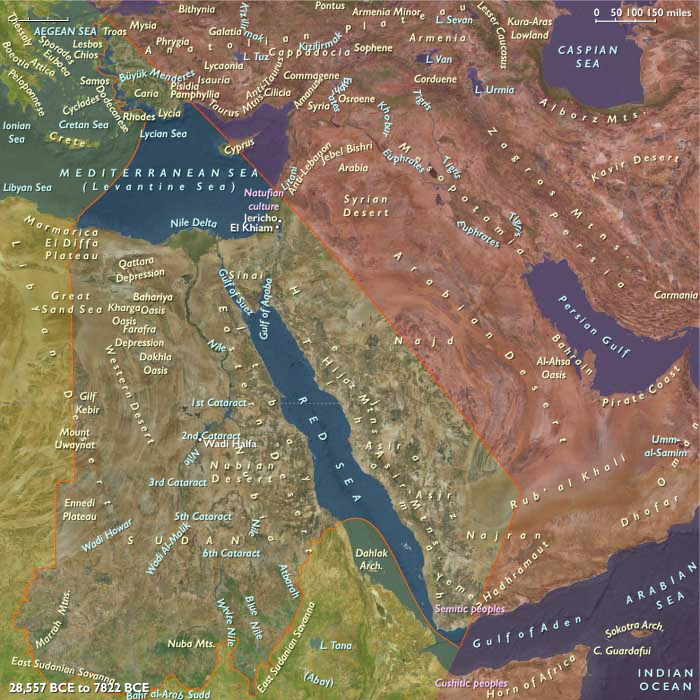
The Near and Middle East (28,577 – …
Years: 28577BCE - 7822BCE
The Near and Middle East (28,577 – 7,822 BCE): Late Pleistocene–Early Holocene — Warming Shores, Spring Worlds, and Broad-Spectrum Economies
Geographic & Environmental Context
Across the millennia of deglaciation, the Near and Middle East cohered as a chain of water-anchored landscapes:
-
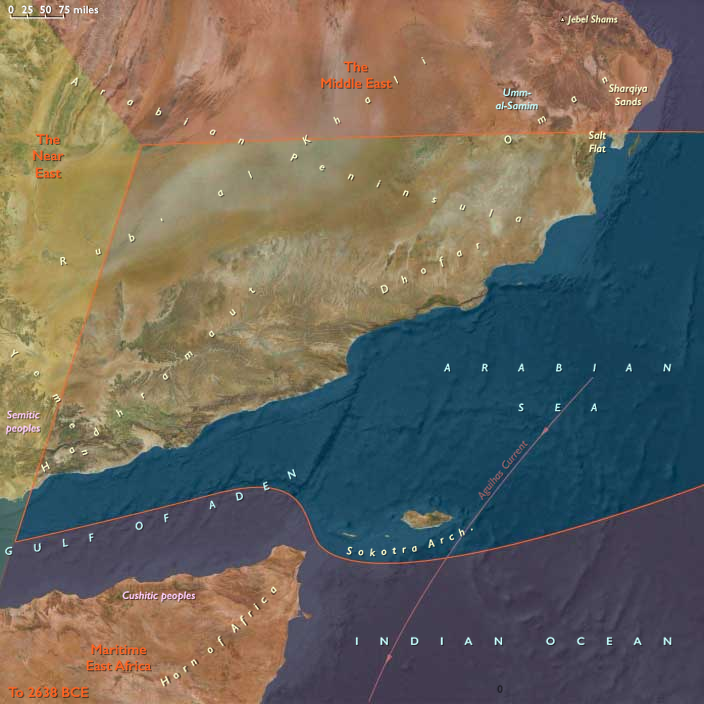
Southeast Arabia—the Dhofar escarpments with khareef fog-forests, the Ḥaḍramawt–Mahra wadi fans, the al-Wusta/Sharqiyah gravel and dune seas, and Socotra’s Hagghier uplands—turned inward to springs and outward to a retreating Aden–Arabian Sea shoreline.
-
The Middle East—Zagros–Upper Mesopotamia, the Tigris–Euphrates corridors, the Caucasus piedmont, Khuzestan/Fars lowlands, and the advancing Gulf shelf—oscillated between pluvial recovery and steppe stress before stabilizing in the Early Holocene.
-
The Near East—the Nile Valley and Delta, Sinai–Negev–Arabah, the southern Levant, western Anatolia’s Aegean littoral, and the Hejaz–Asir–Tihāma—saw drowned shelves, maturing estuaries, and rejuvenated floodplains.
Rising seas re-shaped coasts (Gulf transgression; Aegean embayments), while thawing headwaters revived perennial flow in the great river systems.
Climate & Environmental Shifts
-
Bølling–Allerød (c. 14.7–12.9 ka): Warmer, wetter conditions expanded Zagros gallery woods and Caucasus belts; Ḥaḍramawt/Dhofar wadis ran strong; Nile floods strengthened; Aegean and Gulf coasts grew more productive.
-
Younger Dryas (12.9–11.7 ka): Cooler, drier snapback: steppe spread across Upper Mesopotamia, wadis intermittently failed in SE Arabia, Nile discharge weakened; foragers pivoted to resilient wetland/coastal patches.
-
Early Holocene (post-11.7 ka): Sustained warmth and more reliable monsoons/westerlies: Zagros springs and Tigris–Euphrates marsh–riparian mosaics stabilized; Dhofar fog-forests rebounded; Nile and Aegean floodplains/estuaries matured as the Gulf flooded landward.
Subsistence & Settlement
A triad of broad-spectrum adaptations converged on semi-sedentary water nodes:
-
Southeast Arabia: Seasonal hamlets clustered at springheads and lagoon margins; diets paired gazelle–oryx–ibex with fish, shellfish, turtles, and mangrove resources. Inland rounds gathered fruits/nuts and hunted in the Mahra/Wusta belts; Socotra remained a wooded outpost likely without permanent settlement.
-
Middle East (Zagros–Upper Mesopotamia–Caucasus–Gulf rim): Spring-terrace camps and riparian hamlets exploited gazelle, onager, boar, riverine fish/mollusks, and seeds, acorns, pistachio/almond. In the Early Holocene, some groups tethered wild caprines, edging toward management on Zagros slopes; marsh fishing/waterfowling intensified in the lower Tigris–Euphrates as the Gulf advanced.
-
Near East (Nile–Levant–Aegean–Hejaz/Tihāma): Nile communities deepened fish–fowl–reed economies; Levantine and Aegean foragers harvested shellfish and nearshore fish alongside deer/boar; Red Sea shorelines with relict mangroves supported intermittent foraging.
Settlement was nodal and recurrent—springs, levees, dune spurs, and lagoon bars accruing hearths, pits, and cemeteries across centuries.
Technology & Material Culture
-
Microlithic bladelet/geometrics dominated hunting kits; hafted composite points and resins common.
-
Grinding stones, mortars/querns for nuts/seeds spread widely; bone harpoons/fish gorges, net weights, basketry, and ropework underpinned marsh/estuary fisheries.
-
Ground-stone tools rose late; incipient pottery appeared by the end of the period on the northern Iranian/Caspian and Anatolian fringes, initially for boiling and storage.
-
Early dugouts/rafts and reed craft likely on Nile backwaters and sheltered lagoons; cabotage along Aegean/Gulf/Arabian rims feasible during stable seasons.
Movement & Interaction Corridors
-
Zagros passes (Kermanshah–Khuzestan) funneled goods/people between uplands and Khuzestan plains; Karkheh–Karun–Shatt al-Arab backwaters linked to the Upper Gulf.
-
Caucasus Kura–Araxes fans connected highlands to Iranian forelands.
-
Ḥaḍramawt–Mahra–Dhofar wadis stitched coast and interior; short maritime hops likely reached the Horn of Africa.
-
The Nile remained the subregion’s master axis; Aegean island-hops and Red Sea shore lanes tied capes and wadi mouths.
These intertwined routes provided redundancy: when wadis failed or steppe widened, marsh, lagoon, and coast supplied calories and salt.
Cultural & Symbolic Expressions
-
Ochre burials and river/spring offerings recur from Zagros to the Nile; house-based ritual—hearth deposits, ancestor interments, stone slab markers—emerged in semi-sedentary camps.
-
Petroglyphs on Dhofar/Haima desert margins and Zagros outcrops (caprids, equids, processions) may root in these horizons.
-
Shell terraces and levee mounds served as feasting grounds and mnemonic landmarks, formalizing access to water and fisheries.
Environmental Adaptation & Resilience
A shared risk-spreading grammar took shape:
-
Dietary breadth + storage (dried meat/fish, nut pastes) buffered Younger Dryas shocks.
-
Flexible rounds (wetland–upland–coast) tracked shifting isohyets and resource pulses.
-
Proximity to springs/marshes anchored overwintering; early caprine tethering and focused seed processing foreshadowed managed food webs.
-
Lagoon/marsh anchoring during arid pulses sustained semi-sedentism without agriculture.
Long-Term Significance
By 7,822 BCE, the Near and Middle East had become a water-anchored, semi-sedentary world: mapped wadi networks in SE Arabia; spring-terrace and marsh hamlets in Zagros–Mesopotamia edging toward herd and seed management; and Nile–Aegean–Red Sea littorals refining wetland and coastal economies.
These intertwined traditions—grinding and storage, spring/levee fidelity, caprine protomanagement, marsh and lagoon fisheries, and seasonal cabotage—constituted the operating code from which the region’s first Neolithic cultivation and herding communities would soon crystallize.
Topics
- The Upper Paleolithic
- Bølling Oscillation
- Allerød Oscillation
- Late Glacial Maximum
- Younger Dryas
- Neolithic Revolution
Commodoties
Subjects
Regions
Subregions
Related Events
Showing 10 events out of 69584 total
Years: 28577BCE - 7822BCE
Topics
- The Upper Paleolithic
- Bølling Oscillation
- Allerød Oscillation
- Late Glacial Maximum
- Younger Dryas
- Neolithic Revolution
Commodoties
Subjects
Regions
Subregions