The Aurignacian Tool Industry (32,000–27,000 BCE) The…
32013 BCE to 30286 BCE
The Aurignacian Tool Industry (32,000–27,000 BCE)
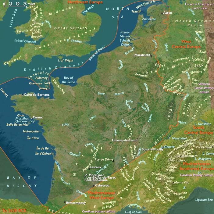
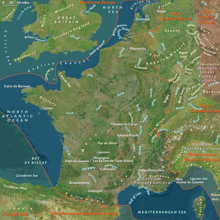
The Aurignacian tool industry, named after the site of Aurignac in France, flourished between 32,000 and 27,000 BCE, marking a significant phase in Upper Paleolithic technology. This industry is associated with Early European Modern Humans (EEMH) and represents a notable advancement in stone tool production and artistic expression.
Key Characteristics of Aurignacian Tools
- Parallel fluting along the entire margin of tools, a defining feature of Aurignacian craftsmanship.
- Increased use of blades (long, thin flakes of stone) instead of the broader flakes characteristic of earlier tool traditions.
- Bone and antler tools, including awls, points, and needles, reflecting a diversification of materials.
- The emergence of carved figurines, beads, and engravings, suggesting a growing symbolic and artistic culture.
Cultural and Technological Impact
The Aurignacian industry played a crucial role in the spread of modern humans across Europe and is often associated with the displacement of Neanderthals. The refined tool-making techniques and the appearance of early art and symbolic artifacts suggest a complex cognitive and cultural framework, setting the stage for further advances in Upper Paleolithic societies.
Groups
Subjects
Regions
West Europe
View →Subregions
Atlantic West Europe
View →Related Events
No active filters.
Showing 10 events out of 69610 total
Australian aboriginal people show considerable genetic diversity but are quite distinct from groups outside Australia.
Having come originally from somewhere in Asia, they have been in Australia for at least forty thousand years.
Most of the continent, including the southwest and southeast corners as well as the Highlands of the island of New Guinea, was occupied by thirty thousand years before the present.
Australia by 30,000 BCE has already been inhabited for, at minimum, twenty thousand years by the aboriginal people.
Modern humans reach East Asia (Korea, Japan) around thirty thousand years BP.
Archaeologists also find evidence of Stone Age technology in Aq Kopruk and Hazar Sum in north central Afghanistan.
Plant remains in the foothills of the Hindu Kush mountains indicate that northern Afghanistan is one of the earliest places to domestic plants and animals.
Paleolithic peoples had probably roamed Afghanistan as early as 100,000 BCE.
A cave at Darra-i-Kur in Badakhshan, where twentieth-century archaeologists will discover a transitional Neanderthal skull fragment in association with Mousterian-type tools, is the earliest definite evidence of human occupation; the remains are of the Middle Paleolithic, dating about 30,000 years BCE.
The questions of how, when, and why the first peoples entered the Americas remain subjects of active research, though recent genomic advances have significantly refined our understanding. While there is general agreement that the Americas were first settled by peoples who migrated from Asia across Beringia, the migration patterns, timing, and genetic origins have proven far more complex than previously recognized.
Archaeological evidence suggests that widespread human habitation of the Americas occurred during the late glacial period (roughly 16,500-13,000 years ago), following the Last Glacial Maximum. However, sites like White Sands, New Mexico, suggest human presence as early as 21,000-23,000 years ago, potentially during the height of glaciation.
Whole-genome studies have revolutionized understanding of Native American origins, revealing that while most ancestry stems from a shared founding population, at least four distinct streams of Eurasian migration contributed to present-day and prehistoric Native American populations. Ancient DNA analysis of individuals like the 12,600-year-old Anzick-1 child (associated with Clovis artifacts) confirms genetic continuity between early inhabitants and modern Native Americans, contradicting theories of population replacement.
Current research supports a model involving initial migration from a structured Northeast Asian source population, followed by a period of isolation in Beringia, and subsequent coastal migration into the Americas. This founding population then diversified within the continent, splitting into northern and southern lineages around 14,500-17,000 years ago. Additionally, some Amazonian populations show genetic signatures suggesting ancestry from a second source related to indigenous Australasians, indicating an even more complex founding history.
Rather than simple single versus multiple migration models, the genetic evidence points to a nuanced process involving multiple ancestral streams, periods of isolation, rapid expansion, and subsequent diversification within the Americas.
Southeast Indian Ocean (28,577–7,822 BCE): Ice Retreat and Expanding Shores
Geographic & Environmental Context
The subregion of Southeast Indian Ocean includes Kerguelen east of 70°E and Heard Island and McDonald Islands. Kerguelen’s eastern plateaus and fjord systems dominated the landscape, while Heard Island’s volcanic massif of Big Ben rose above glaciated coasts. The McDonald Islands remained small, rugged, and volcanically active, barely peeking above stormy seas.
Climate & Environmental Shifts
This epoch bridged the Last Glacial Maximum (c. 26,000–19,000 BCE) and the slow deglaciation that followed. Icefields on Kerguelen and Heard expanded dramatically at first, carving valleys and pushing tongues of ice toward the coasts. After 20,000 BCE, retreat began, revealing tundra and freshwater lakes. Sea levels gradually rose—by the end of the epoch, they had climbed tens of meters, re-drowning coastal shelves. The Southern Ocean warmed slightly, altering circulation and plankton blooms.
Subsistence & Settlement
Still uninhabited by humans, the islands were ecologically vibrant. Expanding tundra vegetation reclaimed glacial forelands. Migratory seabirds—especially penguins and petrels—flourished as new rookeries opened on ice-free coasts. Seal and sea lion populations rose in tandem with available haul-out sites. Nutrient cycling intensified, with guano-rich soils anchoring ecosystems. Heard’s volcanic activity intermittently reshaped its surface, creating ash-rich habitats that supported pioneering plant communities.
Technology & Material Culture
Globally, this was the era of Upper Paleolithic florescence: composite tools, bone harpoons, and artistic traditions from Lascaux to the Levant. None reached the Southeast Indian Ocean. Survival here would have demanded advanced maritime craft and cold-weather technologies, beyond the known reach of Paleolithic seafarers.
Movement & Interaction Corridors
Marine life moved along the circumpolar current, linking the subregion to Antarctica and Australasia. Whales traced seasonal migrations, while seabirds covered extraordinary distances, knitting together distant ecosystems. These biological corridors laid ecological foundations for later human exploitation of the Southern Ocean.
Cultural & Symbolic Expressions
No symbolic or cultural activity is tied to these islands. Elsewhere, symbolic traditions exploded: figurines, cave art, and ritual landscapes. The Southeast Indian Ocean remained beyond the human mental map, a space unknown yet ecologically rich.
Environmental Adaptation & Resilience
Plant and animal communities adapted to dramatic climatic shifts—retreating glaciers, rising seas, and fluctuating volcanic activity. Recolonization after ice retreat showcased resilience, as mosses, lichens, and seabird-driven nutrient webs rapidly expanded into new niches.
Transition
By 7,822 BCE, the Ice Age was waning. The Southeast Indian Ocean islands stood transformed: glaciers reduced, coasts reshaped, ecosystems rebounding. Though still unseen by humans, they embodied subantarctic resilience at the cusp of the Holocene.
Southwest Indian Ocean (28,577–7,822 BCE): From Glacial Dominance to Holocene Beginnings
Geographic & Environmental Context
The subregion of Southwest Indian Ocean includes Kerguelen west of 70°E, the Îsles Crozet, Prince Edward Island, and Marion Island. Western Kerguelen’s ice-carved plateaus, the rugged volcanic Crozet peaks, and the smaller Prince Edward and Marion Islands defined this scattered maritime landscape.
Climate & Environmental Shifts
At the epoch’s start, glaciers dominated highlands across Kerguelen and the Crozets. By the Holocene transition, ice had retreated considerably, exposing valleys, coasts, and fertile volcanic soils. Sea levels rose globally, redrawing shorelines and submerging land bridges. Winds remained fierce, but slightly warmer temperatures lengthened ice-free seasons. The Southern Ocean’s productivity shifted with changing currents, supporting immense marine populations.
Subsistence & Settlement
Still unpeopled, the islands thrived ecologically. Vegetation expanded onto newly deglaciated slopes—mosses, lichens, and grasses colonized volcanic soils enriched by seabird guano. Seals, penguins, and albatrosses grew in numbers as ice-free coasts multiplied. Whales continued to feed in surrounding waters, making the subregion a biological hotspot.
Technology & Material Culture
Globally, Upper Paleolithic humans refined tools, ornaments, and symbolic practices, yet no trace of such material culture touched these isolated islands. Their inaccessibility underscored the limits of human seafaring in the Pleistocene.
Movement & Interaction Corridors
The Antarctic Circumpolar Current and westerly winds shaped ecosystems and migration. Birds nested across multiple island groups, creating interlinked ecological arcs. Whales moved along predictable feeding circuits. These corridors later drew human whalers and explorers, though in this epoch they remained exclusively natural.
Cultural & Symbolic Expressions
The subregion carried no human symbolic imprint. Instead, its symbolic resonance lay only in the ecological patterns—rookeries as centers of renewal, volcanic peaks as markers of resilience—beyond human perception at the time.
Environmental Adaptation & Resilience
Ecosystems reorganized dynamically as ice retreated. Vegetation colonized bare rock, seabird populations redistributed, and marine mammals adapted to shifting ice margins. The resilience of life in this harsh zone foreshadowed ecological strategies that would continue into the Holocene.
Transition
By 7,822 BCE, the glacial epoch was ending. The Southwest Indian Ocean islands emerged into a new climatic regime—still remote, storm-battered, and uninhabited, yet ecologically flourishing. They stood as silent reservoirs of life at the dawn of a warmer age.
Northeastern Eurasia (28,577 – 7,822 BCE): Late Pleistocene–Early Holocene — Beringian Migrations, Salmon Economies, and the First Pottery Traditions
Geographic & Environmental Context
At the end of the Ice Age, Northeastern Eurasia—stretching from the Urals to the Pacific Rim—was a vast, deglaciating world of river corridors, boreal forests, and emerging coasts. It included three key cultural–ecological spheres:
-
Northwest Asia — the Ob–Irtysh–Yenisei heartlands, Altai piedmont lakes, and Minusinsk Basin, bounded by the Ural Mountains to the west. Here, deglaciation produced pluvial lake systems, and forest belts climbed into the Altai foothills.
-
East Europe — from the Dnieper–Don steppe–forest margins to the Upper Volga–Oka and Pripet wetlands, a corridor of interlinked rivers and pluvial basins supporting rich postglacial foraging.
-
Northeast Asia — the Amur and Ussuri basins, the Sea of Okhotsk littoral, Sakhalin and the Kuril–Hokkaidō arc, Kamchatka, and the Chukchi Peninsula—a maritime–riverine realm where early Holocene foragers developed salmon economies and pottery traditions under the warming Pacific westerlies.
Together these subregions formed a continuous arc of adaptation spanning tundra, taiga, and coast—an evolutionary laboratory for the technologies and traditions that would later circle the entire North Pacific.
Climate & Environmental Shifts
-
Bølling–Allerød (14,700–12,900 BCE): Rapid warming and higher precipitation expanded boreal forests and intensified riverine productivity across Eurasia’s north. Salmon runs strengthened in the Amur and Okhotsk drainages; pluvial lakes filled the Altai basins.
-
Younger Dryas (12,900–11,700 BCE): A temporary cold–dry reversal restored steppe and tundra, constraining forests to valleys; lake levels fell; inland mobility increased.
-
Early Holocene (after 11,700 BCE): Stable warmth and sustained moisture drove forest advance (pine, larch, birch) and high lake stands; sea levels rose along the Okhotsk and Bering coasts, flooding older plains and establishing modern shorelines.
These oscillations forged adaptable forager systems able to pivot between large-game mobility and aquatic specialization.
Subsistence & Settlement
Across the northern tier, lifeways diversified and semi-sedentism began to take root:
-
Northwest Asia:
Elk, reindeer, beaver, and fish formed broad-spectrum diets. Lakeside camps in the Altai and Minusinsk basins became seasonal home bases, while Ob–Yenisei channels hosted canoe or raft mobility. Forest nuts and berries expanded plant food options in warm phases. -
East Europe:
Along the Dnieper, Don, and Upper Volga, foragers targeted elk, red deer, horse, and beaver, exploiting riverine fish and waterfowl. Repeated occupations at lake outlets and confluences reflect increasing site permanence and food storage. -
Northeast Asia:
The Amur–Okhotsk region pioneered salmon-based economies, anchoring early Holocene villages at river confluences and estuarine terraces. Coasts provided seal, shellfish, seabirds, and seaweeds, while inland foragers pursued elk and musk deer. Winter sea-ice hunting alternated with summer canoe travel along the Sakhalin–Kuril–Hokkaidō chain.
This mosaic of economies—lake fishers, river hunters, and sealers—reflected the continent’s growing ecological diversity.
Technology & Material Culture
Innovation was continuous and regionally distinctive:
-
Microblade technology persisted across all subregions, with refined hafting systems for composite projectiles.
-
Bone and antler harpoons, toggling points, and gorges evolved for intensive fishing and sealing.
-
Ground-stone adzes and chisels appeared, enabling woodworking and boat construction.
-
Early pottery, first along the Lower Amur and Ussuri basins (c. 15,000–13,000 BCE), spread across the Russian Far East—among the world’s earliest ceramic traditions—used for boiling fish, storing oils, and processing nuts.
-
Slate knives and grindstones at Okhotsk and Amur sites show specialized craft economies.
-
Personal ornaments in amber, shell, and ivory continued, while sewing kits with eyed needles and sinew thread supported tailored, waterproof clothing.
These toolkits established the technological template for later northern and Pacific Rim foragers.
Movement & Interaction Corridors
-
Ob–Irtysh–Yenisei river systems funneled movement north–south, linking the steppe with the taiga and tundra.
-
Altai and Ural passes maintained east–west contact with Central Asia and Europe.
-
Dnieper–Volga–Oka networks merged the European forest-steppe into the greater Eurasian exchange field.
-
In the Far East, the Amur–Sungari–Zeya–Okhotsk corridor unified interior and coast, while the Sakhalin–Kuril–Hokkaidō arc allowed short-hop voyaging.
-
Across the Bering Strait, fluctuating sea levels intermittently connected Chukotka and Alaska, maintaining Beringian gene flow and cultural exchange.
These conduits supported both biological and technological diffusion at a continental scale.
Cultural & Symbolic Expressions
-
Ochre burials with ornamented clothing and ivory or antler goods reflect deep symbolic continuity from the Upper Paleolithic.
-
Petroglyphs and engravings in the Altai and Minusinsk basins, and later in Kamchatka, depict large animals, waterbirds, and solar motifs.
-
Amur basin figurines and carved marine-mammal and fish effigies attest to ritualized relationships with food species.
-
In the Far East, early evidence of first-salmon and bear-rite traditions foreshadows later Ainu and Okhotsk ceremonialism.
Across all subregions, water and game remained the core of spirituality, connecting people to cyclical abundance and ancestral landscapes.
Environmental Adaptation & Resilience
Foragers across Northeastern Eurasia met environmental volatility with creative versatility:
-
Zonal mobility (taiga–tundra–coast) and multi-season storage (dried meat, smoked fish, rendered oils) stabilized food supply.
-
Boat and ice technologies extended reach across seasons.
-
Broad-spectrum diets cushioned against climatic downturns.
-
Flexible dwellings and social alliances allowed fission and fusion as resources shifted.
-
Memory landscapes—engraved rocks, ritual mounds, named rivers—preserved continuity through spatial change.
Genetic and Linguistic Legacy
The Beringian population standstill during the Late Glacial created a deep ancestral pool for both Paleo-Inuit and First American lineages, while reciprocal migration reconnected Chukchi, Kamchatkan, and Amur populations after sea-level rise.
These long-lived networks seeded circum-Pacific cultural parallels in salmon ritual, dog-traction, maritime hunting, and composite toolkits, forming the northern backbone of later trans-Pacific cultural continuity.
Long-Term Significance
By 7,822 BCE, Northeastern Eurasia had become one of the world’s great centers of forager innovation:
-
Northwest Asia’s pluvial lakes fostered early semi-sedentism and the first rock art of Siberia.
-
East Europe’s river–lake foragers stabilized broad-spectrum economies bridging steppe and forest.
-
Northeast Asia’s salmon-rich coasts and early pottery traditions created the technological and ritual matrix that would radiate across the North Pacific.
This continental synthesis of aquatic resource mastery, ceramic innovation, and long-range mobility defined the emerging Holocene north—a zone where people and landscape adapted together through water, ice, and memory.
Northeast Asia (28,577 – 7,822 BCE): Upper Paleolithic II — Beringian Standstill, Early Pottery Horizons, and Salmon Towns
Geographic and Environmental Context
Northeast Asia includes eastern Siberia east of the Lena River to the Pacific, the Russian Far East (excluding the southern Primorsky/Vladivostok corner), northern Hokkaidō (above its southwestern peninsula), and extreme northeastern Heilongjiang.
-
Anchors: the Lower/Middle Amur and Ussuri basins, the Sea of Okhotsk littoral (Sakhalin, Kurils), Kamchatka, the Chukchi Peninsula (with Wrangel Island offshore), northern Hokkaidō, and seasonally emergent shelves along the Bering Sea and northwest Pacific.
Climatic Crisis and Population Transformation During the LGM
Between roughly 28,500 and 20,000 years ago, the onset of the Last Glacial Maximum (LGM) profoundly altered Northeast Asia. Ice sheets, permafrost expansion, and ecological fragmentation reduced habitable zones across Siberia.
During and immediately after this period, the Ancient North Siberians were largely replaced by populations carrying ancestry closely related to East Asians. This was not a simple migration but a prolonged process of demographic turnover, admixture, and regional extinction.
Out of this transformation emerged two closely related populations:
-
Ancestral Native Americans
-
Ancient Paleosiberians (AP)
Paleoclimatic modeling strongly supports southeastern Beringia as a long-term refugium during the LGM, providing a stable ecological zone where these populations could persist, interact, and differentiate.
Climate and Environmental Shifts
-
Bølling–Allerød (c. 14,700–12,900 BCE): warming and moisture increase expanded boreal forest into valleys; salmon runs intensified; nearshore productivity rose.
-
Younger Dryas (c. 12,900–11,700 BCE): brief return to cooler, drier conditions; tundra patches expanded but ice-free coasts still offered reliable marine resources.
-
Early Holocene (after c. 11,700 BCE): stabilizing warmth and rising sea level reshaped shorelines; taiga expanded fully; rich riverine and estuarine habitats matured.
Subsistence and Settlement
-
Deglaciating coasts supported seal and salmon economies; intertidal shellfish beds and seabird rookeries fueled seasonal aggregation.
-
In warming phases, diets diversified toward fish (salmon, sturgeon), small game, and plant foods (nuts, roots, berries).
-
Younger Dryas prompted higher mobility and renewed emphasis on large herbivores where herds persisted.
-
Early Holocene villages favored river confluences and coastal terraces, ideal for salmon weirs and broad foraging radii.
Technology and Material Culture
-
Microblade production refined; hafted composite points standardized for hunting and sealing.
-
Bone/antler harpoons with toggling tips; barbed fishhooks; sewing kits for tailored garments and waterproof seams.
-
Early pottery appears in the Lower Amur–Russian Far East and spreads to surrounding basins—among the world’s earliest ceramic traditions—used for fish oils, stews, and nut processing.
-
Ground-stone adzes for wood-working and dugout canoe manufacture; slate knives on some Okhotsk coasts.
Movement and Interaction Corridors
-
Amur–Sungari waterway integrated interior and coast; Sakhalin–Kuril–Hokkaidō island chain enabled short-hop voyaging.
-
Beringian standstill: populations on both sides of the strait developed long-term ties; fluctuating sea levels modulated contact.
-
Seasonal sea-ice bridges facilitated winter travel; summer lanes favored canoe movement.
Cultural and Symbolic Expressions
-
Carved bone and ivory figurines, zoomorphic engravings, and ochre burials persisted, signaling continuity with earlier Upper Paleolithic symbolic systems.
-
Recurrent salmon first-catch rites and bear/sea-mammal treatment practices are inferred from patterned discard and ritualized processing locales.
Environmental Adaptation and Resilience
-
Zonal mobility (taiga–tundra–coast) and storage (dried fish, rendered oils) buffered climate swings across Bølling–Allerød → Younger Dryas → Early Holocene.
-
Canoe technologies, fish weirs, and shoreline mapping (capes, tide rips, haul-outs) underwrote stable subsistence as forests spread and shorelines shifted.
Genetic and Linguistic Legacy
-
Prolonged Beringian population structure during late glacial–early Holocene times contributed ancestry to Paleo-Inuit and to the First Americans; reciprocal gene flow linked Chukchi–Kamchatka–Amur families.
-
These deep ties foreshadowed later circum-North Pacific cultural continuities in salmon ritual, dog-traction, and composite toolkits.
Transition Toward the Holocene Forager Horizons
By 7,822 BCE, Northeast Asia featured mature taiga coasts, prolific salmon rivers, and early pottery villages—a landscape primed for the broad-spectrum, semi-sedentary foraging economies that would dominate the Early Holocene and eventually feed into Epi-Jōmon/Satsumon, Okhotsk, and Amur basin cultural florescences.