The history of Assyria proper is roughly …
Years: 909BCE - 766BCE
The history of Assyria proper is roughly divided into three periods, known as Old Assyrian, Middle Assyrian and Neo-Assyrian.
These terms are in wide use in Assyriology and roughly correspond to the Middle Bronze Age, Late Bronze Age and Early Iron Age, respectively.
Beginning with the campaigns of Adad-nirari II from 911 BCE, Assyria again becomes a great power, a status it will maintain over the next three centuries.
Ashurbanipal has advanced Assyrian control to the Mediterranean and built a number of new towns.
The palaces, temples and other buildings raised by him bear witness to a considerable development of wealth, science, architecture and art.
Groups
Topics
Subjects
Regions
Subregions
Related Events
Filter results
Showing 10 events out of 99 total
Near East (909 BCE – 819 CE) Early Iron and Antiquity — Greeks of Ionia, Levantine Tyre, Roman–Byzantine Egypt, Arabia’s Caravans
Geographic and Environmental Context
The Near East includes Egypt, Sudan, Israel, most of Jordan, western Saudi Arabia, western Yemen, southwestern Cyprus, and western Turkey (Aeolis, Ionia, Doris, Lydia, Caria, Lycia, Troas) plus Tyre (extreme SW Lebanon).-
Anchors: the Nile Valley and Delta; Sinai–Negev–Arabah; the southern Levant (with Tyre as the sole Levantine node in this subregion); Hejaz–Asir–Tihāma on the Red Sea; Yemen’s western uplands/coast; southwestern Cyprus; western Anatolian littoral (Smyrna–Ephesus–Miletus–Halicarnassus–Xanthos; Troad).
Climate & Environment
-
Nile’s late antique variability; Aegean storms seasonal; Arabian aridity persistent but terraces/cisterns mitigated.
Societies & Political Developments
-
Western Anatolia Greek city-states (Ionia–Aeolia–Doria, with Troad): Miletus, Ephesus, Smyrna, etc.
-
Tyre (sole Near-Eastern Levantine node here) dominated Phoenician seafaring.
-
Egypt (Ptolemaic → Roman → Byzantine): Nile granary and Christianizing hub.
-
Arabian west: caravan kingdoms and Hejaz–Asir oases; western Yemen incense terraces and caravan polities.
-
Southwestern Cyprus embedded in Hellenistic–Roman maritime circuits.
Economy & Trade
-
Grain–papyrus–linen from the Nile; olive–wine Aegean; incense–myrrh from Yemen; Red Sea lanes linked to Aden–Berenike nodes (outside core but connected).
-
Tyre exported craft goods and purple dye.
Technology & Material Culture
-
Iron agriculture and tools; triremes and merchant galleys; advanced terracing, cisterns; lighthouse/harbor works.
Belief & Symbolism
-
Egyptian polytheism → Christianity (Alexandria); Greek civic cults; Tyrian traditions; Arabian deities; monasticism along Nile/Desert.
Adaptation & Resilience
-
Canal maintenance buffered Nile shocks; terraces/cisterns stabilized Arabian farming; Aegean coastal redundancy protected shipping routes.
Transition
By 819 CE, the Near East was a multi-corridor world of Nile granaries, Ionia’s city-coasts, Tyre’s Phoenician legacy, and Arabian incense roads — a foundation for the medieval dynamics ahead (Ayyubids in Syria/Egypt next door, Abbasids beyond, and the Ionian–Anatolian littoral under Byzantine/Nicaean arcs).
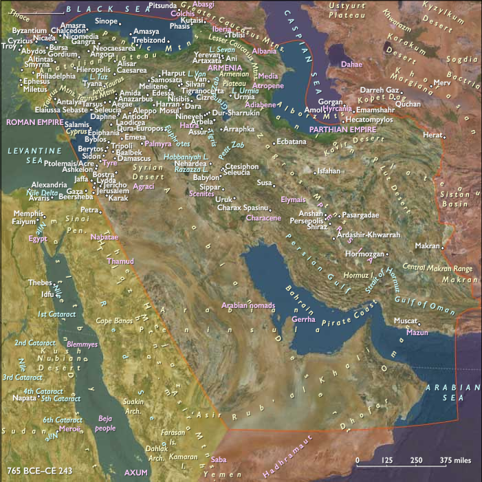
Middle East (909 BCE – 819 CE) Early Iron and Antiquity — Urartu, Achaemenids, Parthians, Sasanian Frontiers
Geographic and Environmental Context
The Middle East includes Iraq, Iran, Syria, Armenia, Georgia, Azerbaijan, eastern Jordan, most of Turkey’s central/eastern uplands (including Cilicia), eastern Saudi Arabia, northern Oman, Qatar, Bahrain, the UAE, northeastern Cyprus, and all but the southernmost Lebanon.-
Anchors: the Tigris–Euphrates alluvium and marshes; the Zagros (Luristan, Fars), Alborz, Caucasus (Armenia–Georgia–Azerbaijan); northern Syrian plains and Cilicia; Khuzestan and Fars lowlands; the Arabian/Persian Gulf littoral (al-Ahsa–Qatar–Bahrain–UAE–northern Oman); northeastern Cyprus and the Lebanon coastal elbow (north).
Climate & Environment
-
Continental variability; oases survived by canal upkeep; Gulf fisheries stable; Caucasus snows fed headwaters.
Societies & Political Developments
-
Urartu (9th–6th c. BCE) fortified Armenian highlands;
-
Achaemenid Persia (6th–4th c. BCE) organized satrapies across Iran, Armenia, Syria uplands, Cilicia; Royal Road linked Susa–Sardis through our zone.
-
Hellenistic Seleucids, then Parthians (3rd c. BCE–3rd c. CE) and Sasanians (3rd–7th c. CE) ruled Iran–Mesopotamia; oases prospered under qanat/karez and canal regimes.
-
Transcaucasus (Armenia, Iberia/Georgia, Albania/Azerbaijan) oscillated between Iranian and Roman/Byzantine influence; northeastern Cyprus joined Hellenistic–Roman networks.
-
Arabian Gulf littoral hosted pearling/fishing and entrepôts (al-Ahsa–Qatif–Bahrain).
Economy & Trade
-
Irrigated cereals, dates, cotton, wine; transhumant pastoralism; Gulf pearls and dates.
-
Long-haul Silk Road and Royal Road flows; qanat irrigation expanded in Iran.
Technology & Material Culture
-
Iron plowshares, tools, and weapons; fortifications; qanat engineering; road stations (caravanserais earlier variants).
-
Arts: Urartian bronzes; Achaemenid stonework; Sasanian silver; Armenian and Georgian ecclesiastical arts (late).
Belief & Symbolism
-
Zoroastrianism, Armenian/Georgian Christianity, local cults; Jewish and early Christian communities in oases/ports; syncretism in frontier cities.
Adaptation & Resilience
-
Canal/qanat redundancy, pasture–oasis integration, distributed entrepôts (northeastern Cyprus, Gulf) hedged war and drought.
Transition
By 819 CE, the Middle East was a layered highland–oasis–Gulf system under Sasanian–Byzantine frontiers giving way to Islamic polities.
Near East (909 BCE – 819 CE) Early Iron and Antiquity — Greeks of Ionia, Levantine Tyre, Roman–Byzantine Egypt, Arabia’s Caravans
Geographic and Environmental Context
The Near East includes Egypt, Sudan, Israel, most of Jordan, western Saudi Arabia, western Yemen, southwestern Cyprus, and western Turkey (Aeolis, Ionia, Doris, Lydia, Caria, Lycia, Troas) plus Tyre (extreme SW Lebanon).-
Anchors: the Nile Valley and Delta; Sinai–Negev–Arabah; the southern Levant (with Tyre as the sole Levantine node in this subregion); Hejaz–Asir–Tihāma on the Red Sea; Yemen’s western uplands/coast; southwestern Cyprus; western Anatolian littoral (Smyrna–Ephesus–Miletus–Halicarnassus–Xanthos; Troad).
Climate & Environment
-
Nile’s late antique variability; Aegean storms seasonal; Arabian aridity persistent but terraces/cisterns mitigated.
Societies & Political Developments
-
Western Anatolia Greek city-states (Ionia–Aeolia–Doria, with Troad): Miletus, Ephesus, Smyrna, etc.
-
Tyre (sole Near-Eastern Levantine node here) dominated Phoenician seafaring.
-
Egypt (Ptolemaic → Roman → Byzantine): Nile granary and Christianizing hub.
-
Arabian west: caravan kingdoms and Hejaz–Asir oases; western Yemen incense terraces and caravan polities.
-
Southwestern Cyprus embedded in Hellenistic–Roman maritime circuits.
Economy & Trade
-
Grain–papyrus–linen from the Nile; olive–wine Aegean; incense–myrrh from Yemen; Red Sea lanes linked to Aden–Berenike nodes (outside core but connected).
-
Tyre exported craft goods and purple dye.
Technology & Material Culture
-
Iron agriculture and tools; triremes and merchant galleys; advanced terracing, cisterns; lighthouse/harbor works.
Belief & Symbolism
-
Egyptian polytheism → Christianity (Alexandria); Greek civic cults; Tyrian traditions; Arabian deities; monasticism along Nile/Desert.
Adaptation & Resilience
-
Canal maintenance buffered Nile shocks; terraces/cisterns stabilized Arabian farming; Aegean coastal redundancy protected shipping routes.
Transition
By 819 CE, the Near East was a multi-corridor world of Nile granaries, Ionia’s city-coasts, Tyre’s Phoenician legacy, and Arabian incense roads — a foundation for the medieval dynamics ahead (Ayyubids in Syria/Egypt next door, Abbasids beyond, and the Ionian–Anatolian littoral under Byzantine/Nicaean arcs).
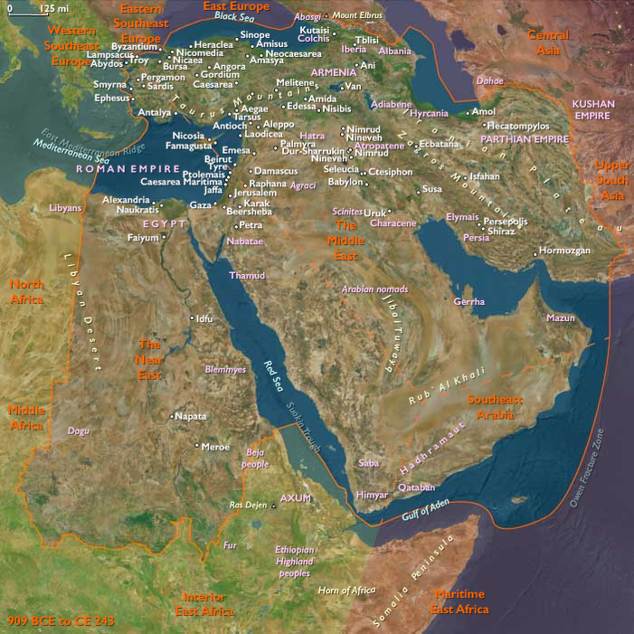
The Middle East: 909–766 BCE
Assyrian Imperial Surge and Expansion
Beginning with Adad-nirari II (911–891 BCE), the Neo-Assyrian Empire rapidly expands, firmly establishing itself as a dominant regional power. By 904 BCE, Babylonia is subdued and reduced to vassalage, and strategic control is secured along the Khabur River. Adad-nirari's military successes lay a robust foundation for Assyria's extensive territorial ambitions.
Consolidation and Brutality under Ashurnasirpal II
Ashurnasirpal II (883–859 BCE) aggressively expands Assyria westward, reaching the Mediterranean by 859 BCE and incorporating influential Phoenician cities. Ashurnasirpal II's administration is marked by brutal reprisals against rebels, including mass executions and mutilations, instilling fear to suppress dissent. His lavish new capital at Kalhu (Nimrud), featuring monumental palaces and relief sculptures, symbolically projects Assyrian power and authority.
Continued Expansion and Conflict under Shalmaneser III
Shalmaneser III (859–824 BCE) extends Assyria's dominance further, notably conquering the powerful Aramaean state of Bit-Adini and engaging a regional coalition led by Damascus. Despite temporary resistance, Shalmaneser III successfully enforces tribute from Phoenician cities, Israel, and Damascus. His reign also witnesses increasing military confrontations with the emerging northern kingdom of Urartu, a significant competitor based near Lake Van.
Internal Turmoil and Territorial Instability
Internal strife emerges toward the end of Shalmaneser III’s rule, culminating in a civil war (828–826 BCE) against his rebellious son, Ashurdaninpal. This turmoil weakens central authority, leading to territorial losses. His successor, Shamsi-Adad V (824–811 BCE), gradually stabilizes the empire, incorporating the strategically vital region of Chaldea. Under Adad-nirari III (811–783 BCE), aided initially by Queen Sammuramat (legendary Semiramis), Assyria reasserts dominance, notably reclaiming Damascus by 804 BCE.
Cultural and Linguistic Influences of the Aramaeans and Phoenicians
The Aramaeans, influential traders settled in Greater Syria, significantly shape regional commerce and culture. They simplify the Phoenician alphabet, spreading Aramaic as the dominant lingua franca across the Middle East, even becoming the official language of the later Persian Empire. Meanwhile, the Phoenicians, despite Assyrian dominance, maintain extensive trade networks and cultural resilience. Artifacts such as the sarcophagus of King Ahiram from Byblos illustrate a vibrant exchange of Assyrian, Egyptian, and Phoenician artistic styles.
Anatolian and Iranian Regional Powers
In Anatolia, the Phrygians, heirs to Hittite cultural traditions, revitalize regional prosperity from their capital at Gordium. They excel in metalworking, woodcarving, and textiles, significantly influencing regional trade and cultural exchange. Concurrently, the Mannaean state emerges around 850 BCE in northwestern Iran, characterized by fortified cities, advanced irrigation, and horse breeding, representing an important regional power.
Emergence and Rivalries of Urartu
In the north, the kingdom of Urartu solidifies under King Aramu (circa 860–843 BCE), becoming a persistent and formidable rival to Assyria. Urartu's strategic fortifications and sustained resistance mark significant geopolitical shifts, frequently clashing with Assyrian ambitions.
Innovations in Assyrian Military and Artistic Expression
Assyrian military advancements, particularly in cavalry tactics, significantly enhance their imperial capabilities. Artistic and architectural achievements, notably the iconic man-headed winged bulls and elaborate palace reliefs, symbolize imperial power and divine sanction, emphasizing the Neo-Assyrian Empire’s cultural sophistication.
Cyprus: Political Consolidation and Urbanization
Cyprus experiences considerable urban growth and political consolidation during this period, with significant centers like the kingdom of Salamis flourishing through extensive trade networks. Monumental "Royal" tombs underscore the island’s rising wealth and social complexity.
Decline and Instability under Shalmaneser IV
Shalmaneser IV (782–772 BCE) faces severe setbacks, culminating in his defeat and death in 772 BCE, triggering internal chaos and territorial losses. This period of instability underscores the challenges Assyria faces in maintaining its extensive empire amidst ongoing regional conflicts.
Thus, the era from 909 to 766 BCE encapsulates a profound and transformative phase in Middle Eastern history, marked by dynamic imperial expansion, significant cultural exchanges, geopolitical rivalries, and internal political struggles that shape the region for centuries.
The Assyrians began to expand to the west in the early part of the ninth century BCE; by 859 they reach the Mediterranean Sea, where they occupy Phoenician cities.
Damascus and Babylon fall to the next generations of Assyrian rulers.
Assyrian rule (875-608 BCE) deprives the Phoenician cities of their independence and prosperity and brings repeated, unsuccessful rebellions.
Urartu reemerges in Assyrian inscriptions in the ninth century BCE as a powerful northern rival.
The Assyrians’ chief adversaries, the Aramaeans, have now settled in Syria.
Under Shalmaneser III, Ashurbanipal’s son and successor, the Assyrians finally manage to conquer Bit-Adini (Beth-Eden), the most powerful Aramaean state on the upper Euphrates.
A short-lived coalition of Levantine and Syrian states, led by Damascus and including Israel, checks Assyria’s westward designs.
The major scene of a sarcophagus from Byblos, known as the sarcophagus of King Ahiram, portrays a bearded ruler seated on a throne that is flanked by winged sphinxes and topped by a lotus frieze.
A priestess offers him a lotus flower.
On the lid two male figures confront one another with addorsed seated lions between them.
Also depicted is a procession of servants and worshipers approaching a table laden with food; below the scene, four lions support the sarcophagus.
Many of the sarcophagus’s ornaments are Egyptian, but the figures wear Asiatic dress, and the lions are characteristic of Assyrian or Hittite art.
The Egyptian influence characteristic of Late Bronze Age art in northwest Canaan is replaced here by Assyrian influences in the rendering of figures and the design of the throne and a table.
Thin carvings in ivory found at Tel Megiddo in modern-day Israel dating from the same period, carved from hippopotamus incisors from Egypt, reflect a similar mixture of styles as well as a strong Aegean influence in the vigorous animal combat scenes.
An inscription of thirty-eight words, found on parts of the rim and the lid of the sarcophagus, is written in the Old Phoenician dialect of Byblos and is the oldest witness to the Phoenician alphabet of considerable length discovered to date.
This script is the parent script of all western alphabets.
The Phoenician alphabet, used for the writing of Phoenician, a Northern Semitic language, is a continuation of the Proto-Canaanite alphabet.
As the formulas of the inscription are so literary in nature, and the cutting of the archaic letters so assured, indicating a form of writing already in common use, a tenth-century BCE date for the inscription has become widely accepted.
Associated items dating to the Late Bronze Age either support an early dating, in the thirteenth century BCE or attest the reuse of an early shaft tomb in the eleventh century BCE.
The Phoenician alphabet, classified as an abjad in that it records only consonant sounds (with the addition of matres lectionis, the use of certain consonants to indicate a vowel), comes to the Greeks in the form of sixteen consonant signs.
However, the Greek alphabet modifies the script to represent vowel phonemes as well.
A total absence of Egyptian objects of the Twentieth and Twenty-first dynasties in Phoenicia contrasts sharply with the resumption of Phoenician-Egyptian ties in the Twenty-second Dynasty of Egypt.
People called Mannaeans live in Iran’s present Azerbaijan province in the second millennium BCE.
Their kingdom is situated east and south of the Lake Urmia, roughly centered around the present-day city of Orumiyeh in the Azerbaijan region of Iran.
Excavations that began in 1956 succeeded in uncovering the fortified city of Hasanlu, once thought to be a potential Mannaean site.
More recently, the site of Qalaichi (possibly ancient Izirtu/Zirta) has been linked to the Mannaeans based on a stela with this toponym found at the site.
The Mannaeans' kingdom begins to flourish around 850 BCE.
They are mainly a settled people, practicing irrigation and breeding cattle and horses.
Their capital is another fortified city, Izirtu (Zirta).
They have expanded by the 820s BCE to become the first large state to occupy this region since the Gutians, later followed by the unrelated Iranic peoples, the Medes and the Persians.
They have developed a prominent aristocracy as a ruling class, who somewhat limit the power of the king.
The region becomes contested ground beginning around 800 BCE between the people of Urartu, who build several forts on the territory of Mannaea, and Assyria.
Babylonia and the whole of southern Mesopotamia had come under Assyrian domination during Dynasty VIII.
In addition to this, hostile Aramean and Sutu tribes had ravaged much of the land during this dynasty, and the Chaldean tribes under Elamite protection had appropriated south eastern Mesopotamia for themselves until they were repressed by the Assyrians.
Years: 909BCE - 766BCE
Groups
Topics
Subjects
Regions
Subregions