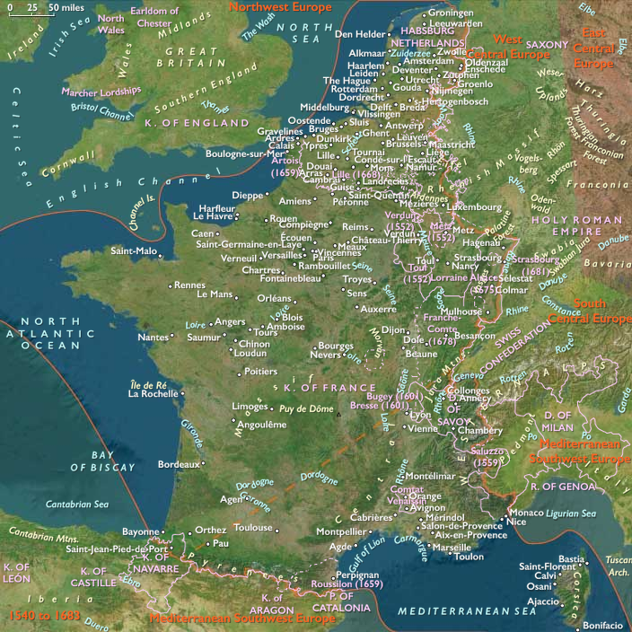
The Académie française originates in an informal…
February 1635 CE
The Académie française originates in an informal group that has grown out of the salons held at the Hôtel de Rambouillet, which have discussed literature during the late 1620s and early 1630s.
Cardinal Richelieu has taken the body under his protection.
In anticipation of the formal creation of the body, several members had been appointed in 1634.
King Louis XIII, at Richelieu's urging, on February 22, 1635, grants letters patent formally establishing the body; according to the letters patent registered at the Parlement de Paris on July 10, 1637, the Académie française was "to labor with all the care and diligence possible, to give exact rules to our language, to render it capable of treating the arts and sciences".
The Académie française has remained responsible for the regulation of French grammar, spelling, and literature.
Richelieu's model, the first academy devoted to winnowing out the "impurities" of a language, is the Accademia della Crusca, founded in Florence in 1582, which had formalized the already dominant position of the Tuscan dialect of Florence as the model for Italian; the Florentine academy had published its Vocabolario in 1612.
Locations
Subjects
Regions
West Europe
View →Subregions
Atlantic West Europe
View →Related Events
Showing 10 events out of 146 total
Eastern West Indies (1636–1647 CE): Sugar Revolutions and Colonial Rivalries
Introduction of the Sugar Plantation Economy
The mid-seventeenth century marked a critical turning point for the Eastern West Indies as the sugar plantation economy, reliant on enslaved labor, was introduced by the Dutch following their expulsion from Brazil in 1640. This economic transformation could not have come at a more crucial time for English and French colonists, whose precarious agricultural economies—previously dependent largely on tobacco—were increasingly threatened by competition from the mainland colonies.
Caribbean tobacco struggled to compete with superior products from the mid-Atlantic colonies, prompting severe economic strain and population decline as settlers migrated to more profitable regions. However, the introduction of the sugar plantation system revitalized the colonial economies, ushering in the period known historically as the "Caribbean Sugar Revolutions." These interrelated agricultural, demographic, social, and economic changes dramatically reshaped the Caribbean, significantly elevating its global economic and political importance.
Expansion of European Plantations and Slave Labor
The adoption of the sugar plantation model by the English and French was directly influenced by the Portuguese experiences in Brazil, while the Dutch provided the crucial infrastructure for the rapidly growing sugar industry through their well-established networks. The Dutch West India Company supplied the necessary enslaved West African laborers, accelerating the region’s demographic transformation. Tens of thousands of Africans were forcibly brought into the Eastern West Indies, profoundly reshaping its social and cultural landscape.
French Colonial Expansion
Under the auspices of the French West India Company, chartered by Cardinal Richelieu in 1635, the French successfully expanded their Caribbean presence. They established strongholds on Martinique and Guadeloupe, from which they would later spread to St. Barthelemy, St. Martin, Grenada, St. Lucia, and the western part of Hispaniola, which Spain formally ceded to France by the Treaty of Ryswick in 1697.
The Arrival of Yellow Fever
This era also witnessed the devastating introduction of yellow fever, first definitively recorded in the New World on the island of Barbados in 1647. The virus, originating from Africa, was likely brought to the Caribbean through the Columbian Exchange, along with its mosquito vector, Aedes aegypti, by enslaved Africans. Unlike the African populations who had developed some immunity, European colonists suffered high mortality rates, significantly impacting colonial societies and economies.
Conclusion
The era from 1636 to 1647 marked profound changes in the Eastern West Indies, setting enduring patterns of agricultural production, labor exploitation, and demographic transformation. The establishment of sugar plantations laid a new economic foundation, making the Caribbean a strategically crucial region for competing European empires and marking the beginning of its long-term dependence on enslaved African labor.
Three to four hundred Japanese returnees from Cambodia had in 1633 been able to reestablish the Japanese settlement in Ayutthaya.
Japanese Shogun Iemitsu Tokugawa, informed of these troubles and what he perceives as attacks on his authority, had from 1634 refused to issue further Red Seal ship permits for Siam.
The usurper king Prasat Thong, desirous of renewing trade, sends a trading ship and an embassy to Japan in 1636, but the embassies are rejected by the Shogun, thus putting an end to direct relations between Japan and Siam.
Japan is concomitantly closing itself to the world at that time, initiating the "Closed Country", or Sakoku, period.
The Dutch take over the lucrative Siam-Japan trade from this time forward.
The island of Mauritius, known to Arab and Austronesian sailors as early as the tenth century, had been first visited by Portuguese sailors in 1507, who had established a visiting base but left the island uninhabited.
Five ships of the Dutch Second Fleet, blown off course during a cyclone while on their way to the Spice Islands, had landed on the island in 1598, naming it in honor of Prince Maurice of Nassau, the Stadtholder of the Netherlands.
The island had not been permanently inhabited for the forty years after its discovery by the Dutch.
Cornelius Gooyer in 1638 establishes the first permanent Dutch settlement in Mauritius with a garrison of twenty-five.
He thus becomes the first governor of the island.
Japan after 1640 allows only Chinese and Dutch ships to visit the country.
The economy of Nagasaki suffers heavily without the annual Portuguese ships from Macao.
Government officials, who are looking for means to relocate the Dutch trading post, had forced the Dutch to move from Hirado to Dejima.
The island of Dejima is on the administrative level part of the city of Nagasaki.
The twenty-five local Japanese families that own the real estate receive an annual rent from the Dutch.
Dejima is a small island, one hundred and twenty by seventy-five meters, linked to the mainland by a small bridge, guarded on both sides, and with a gate on the Dutch side.
It contains houses for about twenty Dutchmen, warehouses, and accommodation for Japanese officials.
The Dutch are watched by a number of Japanese officials, gatekeepers, night watchmen, and a supervisor (otona) with about fifty subordinates.
There are a number of merchants for supplies and catering and about one hundred and fifty tsūji ("interpreters").
They all have to be paid by the VOC.
Like the city of Nagasaki, Dejima is under direct supervision of Edo by a governor (Nagasaki bugyō).
Every Dutch ship that arrives in Dejima is inspected, and sails are seized until that ship is set to leave.
Religious books and weapons are sealed and confiscated.
No religious services are allowed on the island.
Despite the financial burden of the isolated outpost on Dejima, the trade with Japan is very profitable for the VOC, initially yielding profits of fifty percent or more.
At this time, the Dutch mainly trade in silk, cotton, and materia medica from China and India.
The Dutch East India Company had begun the campaign to destroy Portuguese power in the East in the early seventeenth century, by which time the Portuguese had transformed Malacca into an impregnable fortress (the Fortaleza de Malaca, controlling access to the sea lanes of the Straits of Malacca and the spice trade here.)
The Dutch had begun by launching small incursions and skirmishes against the Portuguese.
The first serious attempt had been the siege of Malacca in 1606 by the third VOC fleet from Holland with eleven ships, led by Admiral Cornelis Matelief de Jonge that led to the naval battle of Cape Rachado.
Although the Dutch had been routed, the Portuguese fleet of Don Martin d'Alphonso de Castro, the Viceroy of Goa, had suffered heavier casualties and the battle had rallied the forces of the Sultanate of Johor in an alliance with the Dutch and later on with the Achehnese.
The Dutch with their local allies assault Malacca and wrest it from the Portuguese in January 1641.
This combined Dutch-Johor-Acheh efforts effectively destroys the last bastion of Portuguese power, removing their influence in the Malay archipelago.
As per the agreement with Johor in 1606, the Dutch take control of Malacca and agree not to seek territories or wage war with the Malay kingdoms.
The Council of Batavia in 1642 dispatches Abel Tasman and Franchoijs Visscher on a voyage of which one of the objects is to obtain knowledge of "all the totally unknown provinces of Beach".
Beach appears on maps of the time, notably that of Abraham Ortelius of 1570 and that of Jan Huygen van Linschoten of 1596, as the northernmost part of the southern continent, the Terra Australis, along with Locach.
According to Marco Polo, Locach was a kingdom where gold was “so plentiful that no none who did not see it could believe it”.
Beach was in fact a mistranscription of Locach, Marco Polo’s name for the southern Thai kingdom of Lavo, or Lop Buri, the “city of Lavo”, (after Lavo, the son of Rama in Hindu mythology).
In Chinese (Cantonese), Lavo was pronounced “Lo-huk”, from which Marco Polo took his rendition of the name.
In the German cursive script, “Locach” and “Beach” look similar, and in the 1532 edition of Marco Polo’s Travels published by Simon Grynaeus and Johann Huttich, his Locach had been changed to Boëach, later shortened to Beach.
Linschoten’s very popular 1596 map of the East Indies showed BEACH projecting from the map’s southern edge, leading (or mis-leading) Visscher and Tasman, in their voyage of 1642, to seek Beach with its plentiful gold in a location to the south of the Solomon Islands somewhere between Staten Land near Cape Horn and the Cape of Good Hope.
Confirmation that land exists where the maps show Beach to be had come from Dirk Hartog’s landing in October 1616 on its west coast, which he called Eendrachtsland after the name of his ship.
In accordance with Visscher's directions, Tasman sails first to Mauritius.
The reason for this is that his ships are sailing ships and the best route from one place to another is not always the direct route; of more importance is the direction of the wind.
Tasman has some knowledge of the prevailing winds and so he chooses Mauritius as a turning point and from there a course is set towards what is presumed to be the mainland of Beach, or Terra Australis. (At least part of the western shore of the continent is already known to the Dutch, but the shape of the southern coast is unknown).
Abel Janszoon Tasman A Dutch East India Company navigator commanding a two-vessel expedition meant to map “the remaining unknown part of the terrestrial globe in 1642, sails a course too far south and misses Australia completely.
He sails on to discover an island in the southwest which he names Van Diemen’s land, after his boss, empire builder Anton van Diemen, Governor General of the Dutch East India Company.
He stops briefly on the island, thinking it a part of the mainland, and finds it poor and wild with signs of habitation but no visible populace.
Tasman sights the west coast of Tasmania, north of Macquarie Harbour, on November 24, 1642.
He names his discovery Van Diemen's Land after Anthony van Diemen, Governor-General of the Dutch East Indies.
Proceeding south, Tasman skirts the southern end of Tasmania and turns northeast, now trying to work his two ships into Adventure Bay on the east coast of South Bruny Island where he is blown out to sea by a storm; this area he names Storm Bay.
Tasman anchors two days later to the North of Cape Frederick Hendrick just north of the Forestier Peninsula.
Tasman next lands in Blackman Bay—in the larger Marion Bay.
n attempt is made the next day to land in North Bay; however, because the sea is too rough the carpenter swims through the surf and plants the Dutch flag in North Bay.
Tasman claims formal possession of the land on December 3, 1642.