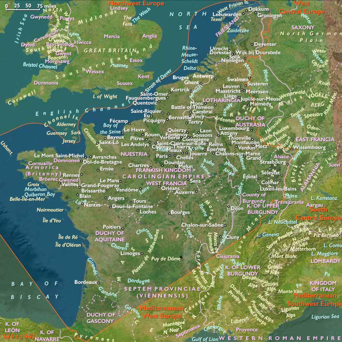
Atlantic West Europe (676–819 CE): Carolingian Coordination,…
676 CE to 819 CE
Atlantic West Europe (676–819 CE): Carolingian Coordination, River Networks, and Atlantic Connectivity
Environment and Settlement
Between 676 and 819 CE, Atlantic West Europe remained a landscape shaped by its Atlantic coasts, navigable rivers, fertile plains, managed forests, and productive agricultural districts. The Gironde, Loire, Seine, Saône, Scheldt, Meuse, and lower Rhine continued to organize movement and settlement, while estuaries, marshes, floodplains, and coastal waters sustained fisheries, salt production, and maritime commerce.
The countryside remained overwhelmingly rural. Villages, estates, monasteries, market settlements, and long-established towns formed a closely connected network across the region. Continued woodland clearance enlarged cultivated landscapes in favorable districts, while forests remained essential sources of timber, fuel, charcoal, pannage, and construction materials. Roads increasingly linked administrative centers, yet rivers continued to carry much of the region's long-distance transport.
Agriculture, Commerce, and Estate Organization
Agricultural production expanded through improved coordination rather than dramatic technological change. Grain, livestock, vineyards, orchards, fisheries, saltworks, and managed woodland supported growing populations and supplied both regional markets and royal institutions. Estate managers increasingly organized storage, milling, viticulture, and animal husbandry across extensive agricultural domains, while villages and smaller farms continued to provide much of the region's productive capacity.
River transport remained the backbone of commerce. The Loire, Seine, Saône, Scheldt, and Meuse carried grain, wine, salt, timber, textiles, ceramics, iron goods, millstones, livestock, and imported products between inland communities and Atlantic ports. Maritime traffic connected Aquitaine, Brittany, Normandy, the Low Countries, Britain, Ireland, Frisia, and the western Mediterranean, while the expanding North Sea economy drew Atlantic West Europe into increasingly active commercial networks.
The widespread circulation of silver deniers encouraged greater monetary consistency across much of the Frankish realm, yet exchange in produce, labor, customary obligations, and local markets remained fundamental to everyday economic life.
Carolingian Administration and Regional Integration
Political authority became more effectively coordinated under the Carolingian rulers, but it continued to operate through existing regional landscapes rather than replacing them. Royal government depended upon networks of counts, bishops, abbots, estate officials, assemblies, and itinerant courts that connected Aquitaine, Burgundy, Neustria, the Low Countries, and other regions while respecting their distinct economic and environmental character.
Royal estates, monasteries, and episcopal centers increasingly functioned as administrative nodes within broader regional systems. Written records, standardized legal practices, estate surveys, and regular assemblies strengthened coordination across the kingdom, while navigable rivers and established road networks allowed officials, merchants, clergy, and royal envoys to travel efficiently between widely separated districts.
Although Carolingian authority became more extensive than that of the later Merovingians, local aristocratic families, regional institutions, and long-established communities continued to shape governance. Aquitaine and Brittany, in particular, retained strong regional identities even as they became more closely integrated into the expanding Frankish political order.
Monasteries, Learning, and Christian Society
Christian institutions reached an unprecedented level of organization during this age. Monasteries expanded their agricultural estates, managed mills and vineyards, reclaimed woodland, copied manuscripts, educated clergy, and provided hospitality for travelers. Cathedral churches likewise strengthened their role as centers of administration, learning, and regional leadership.
The educational reforms associated with the Carolingian Renaissance spread through networks of monasteries, cathedral schools, and royal households rather than through a few celebrated courts alone. Scriptoria at communities such as Tours, Corbie, and Saint-Denis preserved and copied both Christian and classical texts, while the increasing use of Caroline minuscule improved the clarity and consistency of written communication throughout the Frankish world.
Christian worship became more standardized through revised liturgy, improved clerical education, and closer cooperation between bishops, monasteries, and royal authority. Yet religious life remained deeply embedded within local communities, agricultural rhythms, and landscapes that had been sacred for generations.
Legacy of the Age
By 819 CE, Atlantic West Europe had become one of the most coordinated regional landscapes in early medieval Europe. Productive agricultural districts, navigable rivers, Atlantic ports, monasteries, episcopal centers, market settlements, and royal estates formed an integrated system that linked local communities with the wider Carolingian world. Political authority had become more effective, but it remained dependent upon the enduring environmental framework established centuries earlier: fertile river valleys, managed forests, productive estuaries, and resilient rural communities.
The lasting achievement of the age was therefore not simply the expansion of Carolingian rule, but the maturation of institutions that coordinated an already interconnected landscape. Rivers remained the principal arteries of commerce, monasteries and churches became enduring centers of learning and administration, and Atlantic West Europe entered the ninth century as a region whose environmental resilience and institutional richness would continue to shape the medieval history of western Europe.
Images

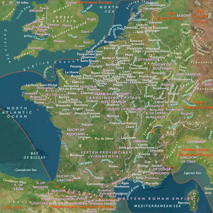
Atlantic West Europe in the Early Medieval (Lower) age
People
Groups
Topics
Commodities
Subjects
Regions
West Europe
View →Subregions