Northern Australia (1396–1539 CE): Coastal Abundance and …
Years: 1396 - 1539
Northern Australia (1396–1539 CE): Coastal Abundance and Inland Mobility
Geographic & Environmental Context
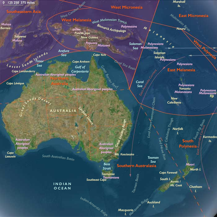
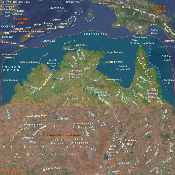
The subregion of Northern Australia includes the northern third of the continent, including the Kimberley, Arnhem Land, Cape York, the Gulf of Carpentaria, and the Top End. This landscape combined monsoonal savannas, sandstone escarpments, mangrove estuaries, and reef-fringed coasts. Seasonal flooding of river plains alternated with long dry spells, shaping settlement and subsistence rhythms.
Climate & Environmental Shifts
This period also fell within the Little Ice Age, but tropical Australia’s dominant rhythm was the monsoon cycle. Wet seasons brought floods, swollen rivers, and abundant aquatic life; dry seasons left cracked soils and sparse vegetation. Rainfall varied significantly across decades, with extended droughts testing inland mobility. Cyclones periodically reshaped coastal zones, redistributing estuarine and reef ecosystems.
Subsistence & Settlement
Aboriginal groups organized settlement around seasonal abundance. During wet seasons, communities clustered near billabongs, estuaries, and floodplains, exploiting fish, turtles, waterfowl, and freshwater plants. Dry seasons prompted dispersal into uplands and escarpments, hunting kangaroo and gathering yams and fruits. Coastal reefs and mangroves supplied shellfish, dugong, and fish year-round. Semi-permanent rock shelters in Arnhem Land preserved evidence of repeated occupation. Mobility and seasonal movement were core strategies.
Technology & Material Culture
Material culture reflected adaptation to coastal and inland ecologies. Bark canoes, dugout canoes, and rafts enabled reef and mangrove exploitation. Stone and bone tools, spear throwers, nets, and fish traps were widespread. Rock art traditions in Arnhem Land and the Kimberley flourished, depicting ancestral beings, marine life, and ceremonial motifs. Bark painting and body decoration expressed cosmological ties. Fire management shaped savannas and improved hunting grounds.
Movement & Interaction Corridors
Extensive overland and coastal routes linked groups across the Top End, Kimberley, and Cape York. Stone, ochre, shells, and ritual knowledge circulated through exchange networks. Maritime corridors connected northern coasts to the Torres Strait, where exchange with Papuan communities had begun centuries earlier. Some early contacts with Macassan trepangers may have occurred in the late 15th or early 16th century, foreshadowing sustained seasonal trade in later centuries.
Cultural & Symbolic Expressions
The Dreaming (Songlines) anchored people to country, mapping ancestral paths across landscapes and seascapes. Rock art immortalized mythic beings, spiritual encounters, and ecological knowledge. Ceremonial life—initiation rites, dances, and rituals tied to wet–dry cycles—sustained community identity and environmental stewardship. Totemic affiliations regulated resource use and affirmed balance between people and land.
Environmental Adaptation & Resilience
Resilience rested on mobility, seasonal movement, and ecological knowledge. Communities shifted camps in rhythm with floodplains, wetlands, and escarpments. Fire-stick farming maintained productive hunting zones and reduced catastrophic burns. Exchange networks allowed scarce goods to circulate during droughts. Flexible social ties and ceremonies ensured collective survival.
Transition
By 1539 CE, Northern Australia was a thriving cultural landscape, shaped by millennia of Indigenous knowledge. Its coasts, reefs, and floodplains supported abundant life, while inland mobility buffered environmental risk. Early hints of outside contact loomed in the Torres Strait, but for now the region’s rhythms remained those of the monsoon, the songline, and the enduring balance between people and country.
Groups
- Australians, Indigenous
- Bininj
- Yolngu
- Tiwi people
- Yanyuwa
- Garrwa people
- Wardaman peopl
- Jawoyn
- Torres Strait Islanders
Topics
Commodoties
Subjects
Regions
Subregions
Years: 1396 - 1539
Groups
- Australians, Indigenous
- Bininj
- Yolngu
- Tiwi people
- Yanyuwa
- Garrwa people
- Wardaman peopl
- Jawoyn
- Torres Strait Islanders
Topics
Commodoties
Subjects
Regions
Subregions