Northern Australia (1540–1683 CE): Wet–Dry Rhythms, Rock …
Years: 1540 - 1683
Northern Australia (1540–1683 CE): Wet–Dry Rhythms, Rock Art Traditions, and Saltwater Corridors
Geography & Environmental Context
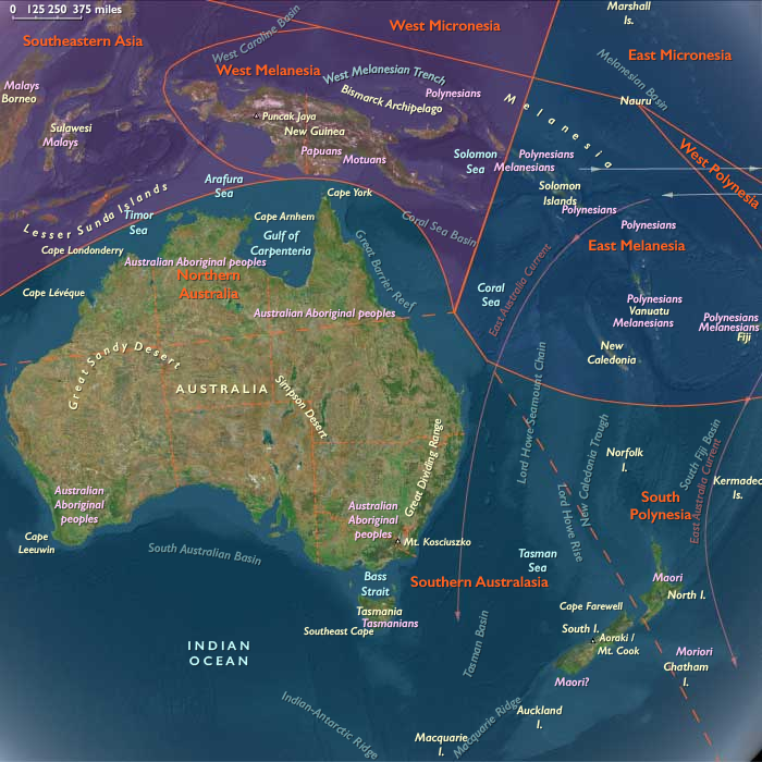
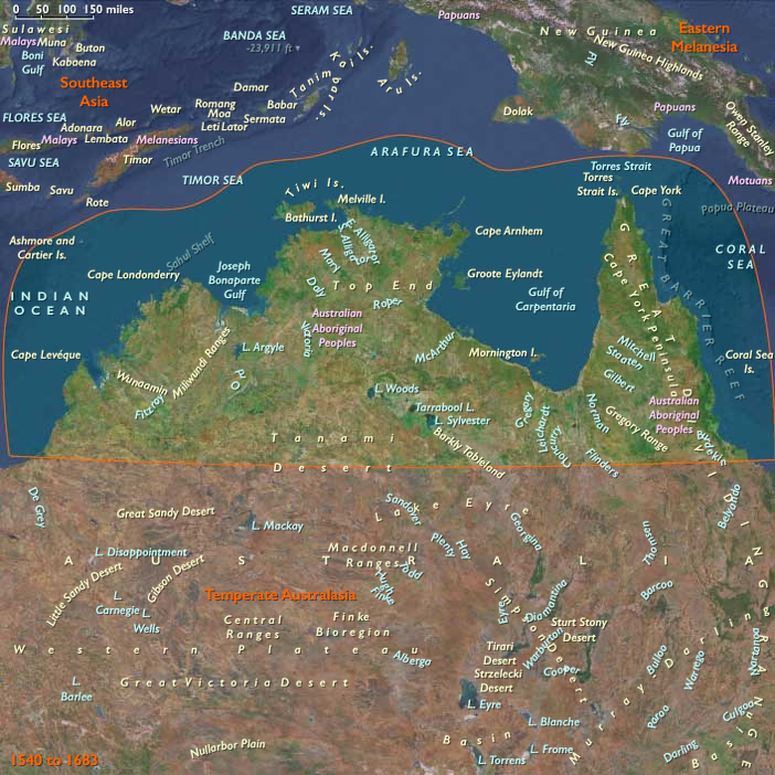
Northern Australia comprises the northern third of the continent—the Kimberley of Western Australia, Arnhem Land and the Top End of the Northern Territory, the Cape York Peninsula of Queensland, and the Gulf of Carpentaria. Anchors include the sandstone escarpments of Arnhem Land, the wetlands of Kakadu, the river systems of the Mitchell Plateau, the Wessel and Tiwi Islands, the estuaries of the Gulf of Carpentaria, and the rainforests and coasts of Cape York. These lands mix rugged escarpments, savannas, monsoon wetlands, and reef-fringed shorelines.
Climate & Environmental Shifts
The region’s tropical monsoon climate alternated between a humid wet season and a cooler, arid dry season. Seasonal flooding rejuvenated wetlands, while long dry periods concentrated people and resources near permanent waterholes. The Little Ice Age brought slightly cooler conditions and heightened rainfall variability, producing decades of extended wet or dry phases. Cyclones periodically devastated coasts, altering mangroves and reshaping settlement patterns, though the abundance of rivers, lagoons, and reefs provided long-term ecological stability.
Subsistence & Settlement
Lifeways followed seasonal cycles of mobility:
-
Wet season: Groups concentrated on higher ground as floodplains expanded, focusing on fishing, gathering waterlilies, harvesting turtles, and cultivating yams.
-
Dry season: Communities dispersed across savannas, hunting kangaroos, wallabies, and emus, harvesting grass seeds, and managing land with fire.
-
Coastal and island groups exploited dugong, fish, shellfish, and seabirds year-round.
-
Cape York communities combined rainforest harvests with marine resources, balancing seasonal rounds between inland and coastal camps.
-
Settlements were mobile, marked by rock shelters, bark shelters, and ceremonial grounds tied to sacred landscapes.
Technology & Material Culture
Toolkits combined ancient traditions with regionally distinctive innovations:
-
Stone tools: ground-edge axes, spear points, and grinding stones for seeds and roots.
-
Wooden implements: spears, boomerangs, digging sticks, and shields crafted from hardwoods.
-
Fishing technologies: woven nets, stone fish traps, and elaborate estuarine weirs (especially in Arnhem Land).
-
Watercraft: bark canoes and rafts were widespread, with dugout canoes introduced to Cape York via Torres Strait Islanders.
-
Art: Arnhem Land rock art flourished, with X-ray paintings depicting fish, turtles, and ancestral beings. Bark paintings recorded cosmological narratives.
-
Textiles and adornments: fiber string bags, body painting, and shell ornaments emphasized both utility and ceremonial symbolism.
Movement & Interaction Corridors
Mobility was guided by ecological calendars and ritual ties:
-
Kimberley and Arnhem Land: Exchange of ochre, pearl shell, and ritual knowledge connected clans across coasts and escarpments.
-
Cape York Peninsula: Networks linked inland and coastal communities, while Torres Strait connections introduced new goods, dugout canoes, and ceremonial influences.
-
Gulf of Carpentaria: Seasonal gatherings along estuaries and islands reinforced ties through exchange and ceremony.
-
Rivers and coasts functioned as highways, guiding seasonal migrations and ritual journeys. No direct European contact occurred in this age, though Macassan trepangers from Sulawesi would soon begin visiting northern coasts in the 18th century.
Cultural & Symbolic Expressions
Spiritual life centered on the Dreaming, expressed in story, song, and image:
-
Rock art depicted both everyday animals and ancestral beings, layering centuries of imagery in Arnhem Land galleries such as Ubirr and Nourlangie.
-
Ceremonies with body painting, dance, and chants reaffirmed ties to land, sea, and spirit.
-
Cape York rituals emphasized initiation and connection to marine spirits.
-
Totemic landscapes encoded cosmological memory into rivers, cliffs, and wetlands, ensuring continuity across generations.
Environmental Adaptation & Resilience
Communities developed flexible strategies to endure environmental stresses:
-
Firestick farming maintained open woodlands and promoted yam growth and game hunting.
-
Food storage—smoked fish, dried kangaroo, and cakes of grass seeds—provided security during lean months.
-
Wetland management included careful regulation of fish trap use and yam harvesting.
-
Mobility allowed groups to relocate when cyclones or drought disrupted local resources.
-
Torres Strait exchanges diversified economies, supplying exotic shells, dugout canoes, and ritual paraphernalia that enriched local systems.
Transition
Between 1540 and 1683, Northern Australia remained defined by wet–dry rhythms, fire regimes, and ritual landscapes. Seasonal calendars structured life, while artistic and ceremonial traditions deepened connections to land and sea. Canoe voyages and exchanges tied Cape York to Torres Strait Islanders, foreshadowing broader regional linkages. Though still untouched by European settlement, the foundations of continuity and resilience laid in this period prepared communities for the external currents that would soon enter their coasts.
Groups
- Australians, Indigenous
- Bininj
- Yolngu
- Tiwi people
- Yanyuwa
- Garrwa people
- Wardaman peopl
- Jawoyn
- Torres Strait Islanders
Topics
Commodoties
Subjects
Regions
Subregions
Years: 1540 - 1683
Groups
- Australians, Indigenous
- Bininj
- Yolngu
- Tiwi people
- Yanyuwa
- Garrwa people
- Wardaman peopl
- Jawoyn
- Torres Strait Islanders
Topics
Commodoties
Subjects
Regions
Subregions