Maritime East Asia (7,821 – 6,094 BCE):…
7821 BCE to 6094 BCE
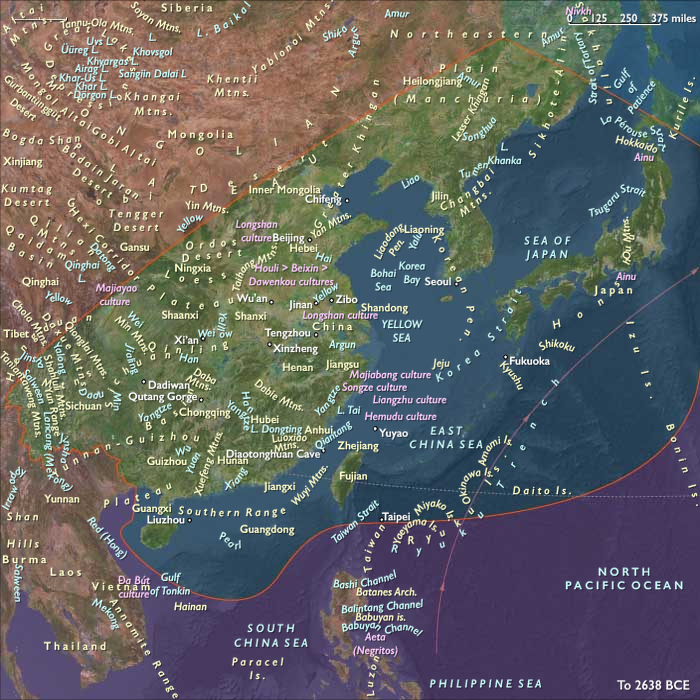
Maritime East Asia (7,821 – 6,094 BCE): Early Holocene — River Deltas, Littoral Villages, and Island Corridors
Geographic & Environmental Context
Maritime East Asia spans the Yellow and Bohai coasts, the Shandong–Liaodong peninsulas, the lower Yellow (Huang He) and Yangtze (Chang Jiang) deltas, the Jiangsu–Zhejiang lagoon belts, Fujian–Guangdong embayments, Taiwan, the Ryukyu chain, and the Korean Peninsula’s southern littoral.
With the Sunda shelves submerged and East Asian seas nearing modern coastlines, drowned river valleys became estuaries, tidal flats, and back-barrier lagoons; offshore, island stairways (Taiwan → southern Ryukyus → Amami–Okinawa → Kyushu) formed natural short-hop routes.
Climate & Environmental Shifts
The Holocene climatic optimum brought warmer SSTs, strengthened East Asian monsoons, and long ice-free seasons:
-
Yangtze and Yellow deltas expanded under regular flooding and high sediment loads, building rich levees and intertidal flats.
-
Kuroshio and its branch currents warmed the Taiwan–Ryukyu–Kyushu arc, fostering coral and seagrass meadows at their northern limits.
-
Storm tracks reworked spits into lagoons but overall variability was modest—an ideal setting for semi-sedentary coastal lifeways.
Subsistence & Settlement
Communities organized along river–lagoon–reef continua in broad-spectrum economies:
-
Deltaic and estuarine zones (lower Yangtze, Hangzhou Bay, Jiangsu–Zhejiang lagoons): semi-sedentary hamlets exploited shellfish banks, mudflat fish, waterfowl, and reeds; wetland tubers and wild rice precursors (Oryza rufipogon) were gathered and tended in backswamps.
-
Shandong–Liaodong and Korean south coasts: rocky-bay fisheries, seaweed and shellfish harvest, deer and boar hunting in oak–pine hinterlands; shell mounds accumulated at favored coves.
-
Fujian–Guangdong embayments & Taiwan: mangrove–lagoon complexes and reef edges supported netting, weirs, and hook fisheries; sago-like palms, taro, yam, and nut trees (e.g., Castanopsis, Lithocarpus) were managed near camps.
-
Ryukyu chain: small coves and karst springs anchored seasonal stations; inter-island short hops linked water, shell, and stone resources.
Settlement remained semi-sedentary but nodal—returning seasonally to the same levees, dune ridges, caves, and headlands.
Technology & Material Culture
A coastal toolkit matured alongside the first ceramics of the East Asian world:
-
Pottery (cord-marked, impressed, fiber-tempered) spread along the maritime lowlands—earliest in the lower Yangtze/Red River spheres, then outward to coastal belts and islands for boiling, fermentation, and storage.
-
Ground-stone adzes and chisels enabled canoe and house carpentry; net weights, bone/shell hooks, and stake-weir elements scaled up mass capture.
-
Dugout canoes (some with raised gunwales) plied estuaries and short channels; woven mats and baskets organized drying and transport.
-
Ornaments of shell, drilled teeth, and polished stone accompanied burials; ochre persisted in ritual contexts.
Movement & Interaction Corridors
The sea was a stitched highway:
-
Delta corridors (Yangtze–Qiantang–Min–Pearl) funneled people and goods between inland terraces and coasts.
-
Island ladders (Taiwan–Ryukyu–Kyushu; Shandong–Korean south coast) afforded day-sail hops and seasonal voyaging; pumice and obsidian hints suggest down-the-line exchange.
-
Kuroshio and coastal drift distributed driftwood, seeds, and craft ideas, while rivers carried lithics and pigments seaward.
These routes created overlapping spheres of shared pottery forms, fishing techniques, and mortuary customs.
Cultural & Symbolic Expressions
Ritual focused on threshold places—capes, springs, and shell terraces:
-
Shell-midden feasts marked seasonal abundance and alliance renewal.
-
Cave and dune burials with pottery and ornaments attest to ancestor veneration near landing places.
-
Petroglyphs and paint at rock shelters recorded boats, fish, cervids, and abstract motifs tied to tide and moon.
The seascape itself—currents, reefs, and capes—functioned as a sacred geography.
Environmental Adaptation & Resilience
Resilience came from portfolio subsistence and water management:
-
Backswamp tending of wetland plants and proto-rice, paired with shellfish and fish storage (smoking, drying, fermenting), buffered lean months.
-
Mangrove and dune stabilization maintained freshwater lenses and protected camps.
-
Mobility across linked nodes (river levee + lagoon bar + island cove) spread risk and ensured continuity through storm seasons.
Long-Term Significance
By 6,094 BCE, Maritime East Asia had consolidated into a ceramic-using, canoe-linked littoral world: deltas, lagoons, reefs, and island chains formed repeatable lifeways that would later incubate rice–wetland intensification, estuarine aquaculture, and longer-range seafaring into the western Pacific.
This was the cradle of coastal pluralism—where land and sea economies fused into a durable cultural ecology.
Commodities
Subjects
Regions
East Asia
View →Subregions