West Melanesia (820 – 963 CE): Highlands …
Years: 820 - 963
West Melanesia (820 – 963 CE): Highlands Gardens, Men’s Houses, and Sea-Lanes of the Bismarck
Geographic and Environmental Context
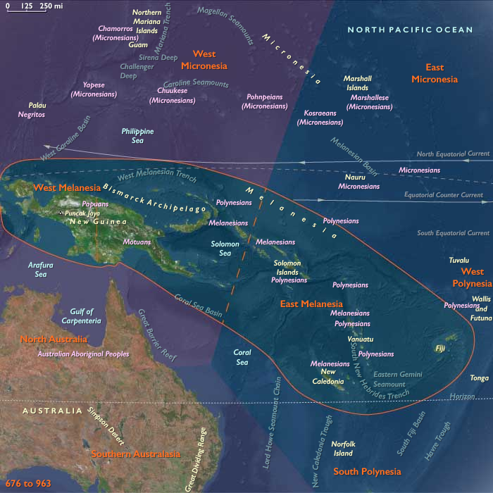
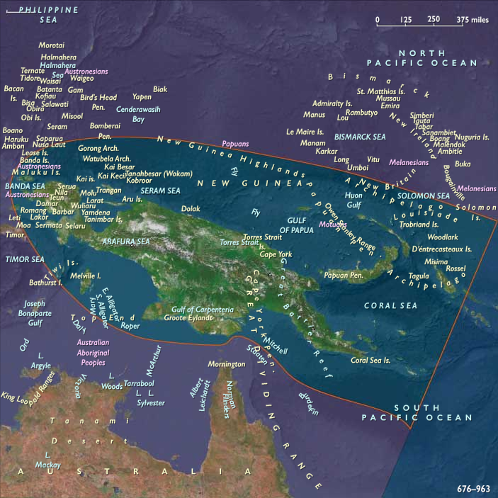
West Melanesia includes New Guinea, Bougainville (the northern Solomon Islands), and surrounding smaller islands (e.g., the Bismarck Archipelago: New Britain, New Ireland, Manus, and the Trobriand/Massim groups).
-
A steep cordillera splits New Guinea, dropping to vast lowland swamps (Papuan Gulf) and big river systems (Sepik, Ramu, Fly).
-
To the northeast, the Bismarck Sea and Vitiaz Strait knit high islands and reef-ringed coasts into dense canoe corridors; Bougainville–Buka sit at the hinge with the Solomons.
-
Ecologies range from montane gardens to sago wetlands, mangrove estuaries, and reef lagoons.
Climate and Environmental Shifts
-
Warm, humid tropics with strong orographic rainfall on windward slopes; brief dry seasons in some leeward pockets.
-
El Niño–Southern Oscillation swings produced patchy droughts in some years (especially in rain-shadow valleys), countered by diversified cropping and exchange.
Societies and Political Developments
-
Highlands (Wahgi, Asaro, Simbu, Enga): populous villages organized by clans and sub-clans; leadership was competitive and achieved—“big-men” mobilized labor for gardens, feasts, and compensation payments. Defensive palisades and ridge-top hamlets appeared where rivalry was acute.
-
Sepik & North Coast: men’s cult houses (haus tambaran) anchored ritual–political life; riverine communities balanced sago, fish, and carving economies, with ritual specialists guiding inter-clan diplomacy.
-
Papuan Gulf & South Coast: stilt-house villages coordinated sago processing, shellwork, and long estuarine voyages; early forms of Hiri-type seasonal trading (later famous among Motu) likely had precedents in this period.
-
Bismarck Archipelago (New Britain/New Ireland/Manus): coastal chiefdomlets leveraged canoe fleets; obsidian (e.g., Talasea sources on New Britain) and fine shell goods moved widely.
-
Massim/Trobriands & adjacent groups: inter-island gift exchange spheres (precursors to later kula circuits) linked islands by ceremonial partnerships and specialist craft.
-
Bougainville–Buka: ranked lineages managed shell-ring valuables, pig herds, and reef rights; coastal–interior alliances balanced competition and trade.
Economy and Trade
-
Staples: highland taro, yam, banana, sugarcane, sweet potato (regionally variable, expanding but not yet universal); lowland sago and coastal fishing/shellfish.
-
Pigs: prime ceremonial wealth for bridewealth, compensation, and feasts.
-
Exchange networks:
-
Highlands–lowlands: salt, stone adzes, bird-of-paradise plumes, and pigs moved against sago, shells, and coastal goods.
-
Bismarck Sea lanes: obsidian, shell valuables, red feathers, canoe hulls, and cured fish circulated between New Britain, New Ireland, Manus, and the north coast of New Guinea.
-
Bougainville–Buka: shell-ring currencies and pigs structured regional wealth and diplomacy.
-
Subsistence and Technology
-
Garden engineering: ditched/raised beds and drainage fields in wetter highland basins; mounding and mulching for yams; terrace edges on slopes; tree-crop (pandanus) management in montane zones.
-
Lowlands: sago groves, fish traps, and mangrove exploitation; smoking and drying extended shelf-life of fish and meat.
-
Canoes: large outrigger sailing canoes with crab-claw or spritsails for open passages; river canoes for Sepik–Ramu transport.
-
Craft: ground-stone adzes, shell knives, bone points; selected areas maintained local pottery traditions (coastal/Bismarck), while many highlands lacked ceramics.
Movement and Interaction Corridors
-
Vitiaz Strait & Bismarck Sea formed the main maritime arterials—New Britain ⇄ north New Guinea ⇄ New Ireland/Manus.
-
Sepik–Ramu–Markham and Highlands–Ramu portages linked river basins to north-coast shipping.
-
Papuan Gulf estuary routes carried sago and shellwork west–east; Bougainville–Buka straits tied northern Solomons to the Bismarck web.
Belief and Symbolism
-
Ancestral skulls, spirit boards, and men’s houses materialized ties to founding beings and land; ritual secrecy governed initiation and cult performance.
-
Feast/compensation cycles converted pigs and shells into social credit, mending conflicts and forging alliances.
-
Sepik river art—carved masks, totems, and painted façades—expressed clan myths and territorial claims; coastal shrines protected voyagers and reefs.
Adaptation and Resilience
-
Poly-resource subsistence (gardens + pigs + sago + fisheries) buffered droughts and crop disease; staggered planting and varietal diversity reduced risk.
-
Defensible settlements and alliance networks mitigated warfare losses; exchange partnerships reopened trade after conflict.
-
Obsidian–shell circuits spread essential cutting edges and wealth tokens across wide distances, stabilizing technology and diplomacy.
Long-Term Significance
By 963 CE, West Melanesia sustained a densely networked archipelago of gardens, men’s houses, and canoe corridors:
-
Highland big-man polities orchestrated labor and ritual through surplus and pigs;
-
Sepik and north-coast riverine societies aligned cult houses with trade;
-
Bismarck and Massim islands carried a maturing ceremonial exchange economy;
-
Bougainville–Buka balanced rank, reef tenure, and shell wealth.
These institutions—engineered gardens, ritual economies, and sea-lanes—provided the durable framework for the intensified fortifications, inter-island alliances, and long-distance ceremonial exchange that would mark the following age.
Groups
Topics
Commodoties
Subjects
- Commerce
- Symbols
- Watercraft
- Decorative arts
- Faith
- Government
- Custom and Law
- Technology
- Human Migration
Regions
Subregions
Years: 820 - 963
Groups
Topics
Commodoties
Subjects
- Commerce
- Symbols
- Watercraft
- Decorative arts
- Faith
- Government
- Custom and Law
- Technology
- Human Migration
Regions
Subregions