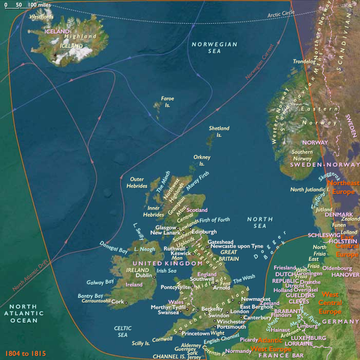
William Smith publishes the first geological map…
October 1815 CE
William Smith publishes the first geological map of Britain in 1815, covering the whole of England and Wales, and parts of Scotland.
Conventional symbols are used to mark canals, tunnels, tramways and roads, collieries, lead, copper and tin mines, together with salt and alum works.
The various geological types are indicated by different colors; the maps are hand colored.
Nevertheless, the map is remarkably similar to modern geological maps of England.
He also publishes his Delineation of the Strata of England in the same year.
Smith was born in the village of Churchill, Oxfordshire, the son of blacksmith John Smith, himself scion of a respectable farming family.
His father had died when Smith was just eight years old, and he was then raised by his uncle.
In 1787, he found work as an assistant for Edward Webb of Stow-on-the-Wold, Gloucestershire, a surveyor.
Quick to learn, he had soon become proficient at the trade.
In 1791, he traveled to Somerset to make a valuation survey of the Sutton Court estate, and building on earlier work in the same area by John Strachey.
He stayed there for the next eight years, working first for Webb and later for the Somersetshire Coal Canal Company.
Smith worked at one of the estate's older mines, the Mearns Pit at High Littleton, part of the Somerset coalfield and the Somerset Coal Canal.
As he observed the rock layers (or strata) at the pit, he realized that they were arranged in a predictable pattern and that the various strata could always be found in the same relative positions.
Additionally, each particular stratum could be identified by the fossils it contained, and the same succession of fossil groups from older to younger rocks could be found in many parts of England.
Furthermore, he noticed an easterly dip of the beds of rock- small near the surface (about three degrees) then bigger after the Triassic rocks.
This gave Smith a testable hypothesis, which he termed The Principle of Faunal Succession, and he began his search to determine if the relationships between the strata and their characteristics were consistent throughout the country.
During subsequent travels, first as a surveyor (appointed by noted engineer John Rennie) for the canal company until 1799 when he was dismissed, and later, he is continually taking samples and mapping the locations of the various strata, and displaying the vertical extent of the strata, and drawing cross-sections and tables of what he has seen.
This earns him the name "Strata Smith".
As a natural consequence, Smith has amassed a large and valuable collection of fossils of the strata he has examined himself from exposures in canals, road and railway cuttings, quarries and escarpments across the country.
He has also developed methods for the identification of deposits of Fuller's earth to the south of Bath.
He publishes his findings with many pictures from his fossil collection, enabling others to investigate their distribution and test his theories.
His collection is especially good on Jurassic fossils he had collected from the Cornbrash, Kimmeridge clay, Oxford clay, Oolitic limestone and other horizons in the sequence.
They include many types of brachiopods, ammonites and molluscs characteristic of the shallow seas in which they were deposited.
Some of the names he coined (like Cornbrash) are still used today for this formation.
In 1799, Smith had produced the first large scale geologic map of the area around Bath, Somerset.
Previously, he only knew how to draw the vertical extent of the rocks, but not how to display them horizontally.
However, in the Somerset County Agricultural Society, he found a map showing the types of soils and vegetation around Bath and their geographical extent.
Importantly, the differing types were colored.
Using this technique, Smith could draw a geological map from his observations showing the outcrops of the rocks.
He took a few rock types, each with its own color.
Then he estimated the boundaries of each of the outcrops of rock, filled them in with color and ended up with a crude geological map.
In 1801, he drew a rough sketch of what would become "The Map that Changed the World".
Because he was unemployed, he could travel across the length and breadth of the country, while meeting some eminent people such as Thomas Coke, 1st Earl of Leicester, and the Duke of Bedford.
Locations
People
Subjects
Regions
North Europe
View →Subregions