Vasco Núñez de Balboa
Spanish explorer, governor, and conquistador
Years: 1475 - 1519
Vasco Núñez de Balboa (c. 1475 – January 15, 1519) is a Spanish explorer, governor, and conquistador.
He is best known for having crossed the Isthmus of Panama to the Pacific Ocean in 1513, becoming the first European to lead an expedition to have seen or reached the Pacific from the New World.
He traveled to the New World in 1500 and, after some exploration, settled on the island of Hispaniola.
He founded the settlement of Santa María la Antigua del Darién in present-day Colombia in 1510, which was the first permanent European settlement on the mainland of the Americas (a settlement by Alonso de Ojeda the previous year at San Sebastián de Urabá had already been abandoned).
Related Events
Filter results
Showing 10 events out of 63 total
Southwest Europe (1396–1539 CE)
Aragonese Sea Lanes, Italian Renaissance, and Habsburg–Valois Wars
Geography & Environmental Context
Southwest Europe encompassed Italy (including Sardinia and Sicily), Malta, southern and eastern Spain (Andalusia, Murcia, Valencia, Catalonia), and the Balearic Islands. Anchors spanned the Po Valley and Venetian–Adriatic gateways, the Apennine spine with Tyrrhenian and Adriatic littorals, the grain and volcanic uplands of Sicily, the rugged Sardinian interior, Malta’s limestone plateau astride central sea-lanes, and Spain’s irrigated huertas and ports from Seville–Cádiz (Atlantic–Mediterranean hinge) through Valencia–Barcelona to the Balearics.
Together these corridors provisioned, armed, and cultured Europe’s busiest inland sea.
Climate & Environmental Shifts
Under the Little Ice Age, winters cooled and variability intensified:
-
Po Valley & Lombardy: alternating droughts and Po floods unsettled rice and wheat rotations.
-
Sicily, Sardinia, southern Spain: recurrent droughts reduced grain and olive yields; citrus and pastoralism buffered loss.
-
Valencia–Murcia huertas: Acequia irrigation offset dry years, but torrential riadas periodically destroyed terraces.
-
Balearics & Malta: thin soils and rainfall swings required cisterns, terracing, and imported grain.
Subsistence & Settlement
-
Italy: Wheat, barley, vines, olives, and, in Lombardy, irrigated rice; urban gardens surrounded the city-states.
-
Sicily & Sardinia: Grain, olives, vines, citrus, and livestock; granaries provisioned Italian and Iberian ports.
-
Southern & eastern Spain: Andalusian cereals, olives, and vines; Valencian and Murcian sugarcane and mulberry–silk; Catalan wool flocks.
-
Islands: Grain, olives, vines, goats, and fisheries sustained mixed economies; harbors provisioned passing fleets.
Major ports—Venice, Genoa, Naples, Palermo, Barcelona, Valencia, Seville, Palma, Cagliari—served as collection hubs for Mediterranean and emerging Atlantic commerce.
Technology & Material Culture
-
Irrigation & terracing: Acequias, qanat-derived galleries, pozzos and cisterns, and stone-bench terraces stabilized yields on coasts and islands.
-
Maritime innovation: Galleys remained indispensable; Italian and Iberian shipyards developed round-hulled naos and early caravels; bronze cannon revolutionized siege and naval warfare.
-
Manufactures: Florentine wool and silk, Venetian glass and books (the Aldine Press), Valencian silk and sugar, Catalan and Neapolitan shipbuilding.
-
Architecture & arts: Gothic–Renaissance transitions—Brunelleschi’s dome, Alberti’s façades, Venetian palazzi; Spanish Mudéjar and early Plateresque; island watchtowers and coastal walls.
Movement & Interaction Corridors
-
Aragonese thalassocracy: The Barcelona–Valencia–Balearics–Sardinia–Sicily–Naples chain formed a western Mediterranean empire later absorbed by Habsburg Spain.
-
Italian sea-lanes: Venice and Genoa dominated Levantine and North African trade; Apennine passes linked inland production to ports.
-
Iberian hinge: Seville–Cádiz bridged Atlantic and Mediterranean routes after 1492, prefiguring global circuits of silver and spice.
-
Islands: Malta, Sardinia, and the Balearics provisioned convoys and guarded corsair-prone straits.
Cultural & Symbolic Expressions
-
Renaissance humanism: Florence, Rome, and Venice led Europe’s artistic renewal; courts of Naples, Ferrara, and Urbino radiated taste into Iberia and the islands.
-
Catholic Christendom: Rome remained pilgrimage center and patron of arts; confraternities and mendicant orders structured devotion.
-
Iberian transformations: The Fall of Granada (1492) ended Nasrid rule; the Inquisition and expulsions reshaped Andalusian society; Valencian and Catalan towns mixed mercantile realism with reformist thought.
-
Islands: Malta, blending Sicilian, Catalan, and Arabic legacies, was granted in 1530 to the Knights Hospitaller as a new crusading bastion.
Environmental Adaptation & Resilience
Cereal–legume rotations, vine–olive intercropping, chestnut economies in uplands, and rice paddies in irrigated lowlands spread risk.
Huerta canals and terrace systems were continuously maintained; state granaries and charitable confraternities mitigated dearth; fisheries and salted staples balanced harvest failures.
Technology & Power Shifts (Conflict Dynamics)
-
Aragonese expansion: Alfonso V (1442) united Naples with Aragon’s sea empire.
-
Italian Wars (1494–1559): France, Spain, and the Empire contested Italy—Fornovo (1495), Cerignola (1503), Agnadello (1509), Pavia (1525), and the Sack of Rome (1527) redefined European warfare and diplomacy.
-
Corsair & Ottoman pressure: Raids struck Sicily, Sardinia, Valencia, and the Balearics; Preveza (1538) confirmed Ottoman naval mastery in the east.
-
Iberian union: The crowns of Aragon and Castile (1479) created a Spanish monarchy projecting power across the peninsula and into the Mediterranean.
Transition
By 1539 CE, Southwest Europe was a crucible of power and culture. Habsburg Spain controlled Naples, Sicily, and Sardinia; Venice and Genoa mediated East–West trades under Ottoman pressure; Malta under the Knights became a bulwark; Valencia–Barcelona and Italian ports thrived on commerce and shipbuilding. Terracing, irrigation, and maritime provisioning sustained populations amid climatic volatility. Renaissance brilliance endured even as corsairs and cannon ushered in a new Mediterranean order.
Mediterranean Southwest Europe (1396–1539 CE): Aragonese Sea Lanes, Italian Renaissance, and Habsburg–Valois Wars
Geographic & Environmental Context
The subregion of Mediterranean Southwest Europe includes Italy (including Sardinia and Sicily), Malta, southern and eastern Spain (Andalusia, Murcia, Valencia, Catalonia), and the Balearic Islands. Anchors span the Po Valley and Venetian–Adriatic gateways, the Apennine spine with Tyrrhenian and Adriatic littorals, the grain and volcanic uplands of Sicily, the rugged Sardinian interior, Malta’s limestone plateau astride central sea-lanes, and Spain’s irrigated huertas and ports from Seville–Cádiz (Atlantic–Mediterranean hinge) through Valencia–Barcelonato the Balearics. Together, these corridors fed and armed Europe’s busiest inland sea.
Climate & Environmental Shifts
Under the Little Ice Age, winters were cooler and variability sharper:
-
Po Valley & northern Italy: alternating droughts and Po floods unsettled wheat/rice rotations; foggy winters extended.
-
Sicily, Sardinia, southern Spain: periodic droughts dented wheat and olive yields; citrus and pastoralism buffered shortfalls.
-
Valencian/Murcian huertas: canal and acequia irrigation moderated dry spells; occasional torrential floods (riadas) damaged terraces.
-
Balearics & Malta: thin soils and rainfall swings drove reliance on cisterns, terracing, and imported grain in lean years.
Subsistence & Settlement
-
Italy: Wheat, barley, vines, and olives dominated; rice spread in Lombardy; urban gardens ringed city-states.
-
Sicily & Sardinia: Grain, olives, vines, citrus, pastoral flocks; granaries supplied Italian and Iberian ports.
-
Southern & eastern Spain: Andalusian cereals, olives, vines; Valencia/Murcia grew rice, sugarcane, mulberry–silk; Catalan uplands raised sheep for wool.
-
Balearics & Malta: Mixed grain, olives, vines, goats; fisheries vital; harbors provisioned passing fleets.
Port cities—Venice, Genoa, Naples, Palermo, Barcelona, Valencia, Seville, Palma, Cagliari—functioned as collection and redistribution hubs for Mediterranean and, increasingly, Atlantic trade.
Technology & Material Culture
-
Irrigation & terracing: acequias, qanat-derived galleries, pozzos/cisterns, stone-walled benches stabilized yields on coasts and islands.
-
Maritime technology: galleys remained the workhorse; Italian and Iberian yards developed round-hulled naos and early caravels; bronze cannon transformed siege and naval warfare.
-
Manufactures: Florentine wool and silk; Venetian glass and print (Aldine press); Valencian silk and sugar; Catalan and Neapolitan shipyards.
-
Architecture & arts: Gothic to Renaissance transitions—Brunelleschi’s dome, Alberti’s façades, Venetian palazzi; Spanish Mudéjar and early Plateresque; island watchtowers and coastal walls.
Movement & Interaction Corridors
-
Aragonese thalassocracy: Barcelona–Valencia–Balearics–Sardinia–Sicily–Naples stitched a western Mediterranean network later inherited by Habsburg Spain.
-
Italian sea-lanes: Venice and Genoa collected Levantine and North African wares; peninsular roads (Via Emilia, Apennine passes) bound inland cities to ports.
-
Iberian hinge: Seville–Cádiz bridged Atlantic and Mediterranean circuits after 1492; Atlantic silver would later amplify these flows.
-
Island waypoints: Malta, Sardinia, and the Balearics provisioned convoys and guarded straits against corsairs.
Cultural & Symbolic Expressions
-
Renaissance humanism: Florence, Rome, and Venice fostered painting, sculpture, architecture, philology; courts of Naples, Ferrara, and Urbino radiated styles into Iberia and the islands.
-
Catholic Christendom: Papal Rome remained a pilgrimage and patronage center; confraternities, processions, and mendicant orders structured urban piety.
-
Iberian transformations: The Fall of Granada (1492) ended Nasrid rule; the Inquisition and expulsion/forced conversion reshaped Andalusian society; Valencian and Catalan towns mixed mercantile pragmatism with reforming currents.
-
Island identities: Genoese, Aragonese, and local elites fused on Corsica/Sardinia; Malta blended Sicilian, Catalan, and Arabic legacies—until 1530, when it became the fief of the Knights Hospitaller.
Environmental Adaptation & Resilience
-
Risk-spreading agriculture: cereal–legume rotations, vine–olive intercropping, and chestnut economies in uplands; rice paddies where water allowed.
-
Water management: canal dredging (Po/Adige), huerta maintenance (Valencia), terrace/cistern upkeep (Malta, Balearics, Ligurian and Amalfi coasts).
-
Urban buffers: state granaries, grain imports, and charitable confraternities mitigated dearth; fisheries and salted staples bridged bad harvests.
Technology & Power Shifts (Conflict Dynamics)
-
Hundred Years’ War (to 1453): peripheral raids reached Languedoc and Catalonia, nudging Aragonese naval policy.
-
Conquest of Naples (1442): Alfonso V of Aragon knit Naples to the Crown of Aragon’s sea empire.
-
Italian Wars (1494–1559): France, Spain, and the Empire fought over Italian hegemony—
-
Battle of Fornovo (1495) checked Charles VIII’s withdrawal;
-
Battle of Cerignola (1503) (Apulia) showcased gunpowder infantry, securing Spanish control in southern Italy;
-
Battle of Agnadello (1509) humbled Venice on the terraferma;
-
Battle of Pavia (1525) delivered a decisive Habsburg victory and Francis I’s capture;
-
the Sack of Rome (1527) shattered papal prestige and artists’ security.
-
-
Western Mediterranean contest: Barbary and Ottoman corsairs raided Sicily, Sardinia, Balearics, and Valencia; Rhodes (1522) fell to the Ottomans, redirecting the Hospitallers to Malta (1530); Preveza (1538) cemented Ottoman naval dominance in the eastern basin with echoes westward.
-
Iberian unification: The crowns of Aragon and Castile united (1479), projecting Spanish power across the peninsula, Italy, and the sea.
Transition
By 1539 CE, Mediterranean Southwest Europe was a crucible of power and culture. Habsburg Spain controlled Naples, Sicily, and Sardinia; Venice and Genoa mediated eastern and western trades under growing Habsburg and Ottoman pressure; Malta stood newly under the Knights as a central bastion; Valencia–Barcelona and Italian ports thrummed with commerce and shipbuilding. Despite climatic swings, terracing, irrigation, and maritime provisioning sustained populations. Renaissance patronage glowed even as Italian Wars and corsair/Ottoman threats remade the political seascape—setting up a long sixteenth century of Spanish predominance and Mediterranean contest.
Portuguese mariners are opening a route around Africa to the East in the fifteenth century.
At the same time as the Castilians, they have planted colonies in the Azores and in the Canary Islands (also Canaries; Spanish, Canarias), the latter of which have been assigned to Spain by papal decree.
The conquest of Granada allows the Catholic Kings to divert their attention to exploration, although Christopher Columbus's first voyage in 1492 is financed by foreign bankers.
In 1493 Pope Alexander VI (Rodrigo Borgia, a Catalan) formally approves the division of the unexplored world between Spain and Portugal.
The Treaty of Tordesillas, which Spain and Portugal sign one year later, moves the line of division westward and allows Portugal to claim Brazil.
New discoveries and conquests come in quick succession.
Vasco Núñez de Balboa reaches the Pacific in 1513, and the survivors of Ferdinand Magellan's expedition complete the circumnavigation of the globe in 1522.
In 1519 the conquistador Hernán Cortes subdues the Aztecs in Mexico with a handful of followers, and between 1531 and 1533 Francisco Pizarro overthrows the empire of the Incas and establishes Spanish dominion over Peru.
In 1493, when Columbus brought fifteen hundred colonists with him on his second voyage, a royal administrator had already been appointed for the Indies.
The Council of the Indies (Consejo de Indias), established in 1524, acts as an advisory board to the crown on colonial affairs, and the House of Trade (Casa de Contratacion) regulates trade with the colonies.
The newly established colonies are not Spanish but Castilian.
They are administered as appendages of Castile, and the Aragonese are prohibited from trading or settling there.
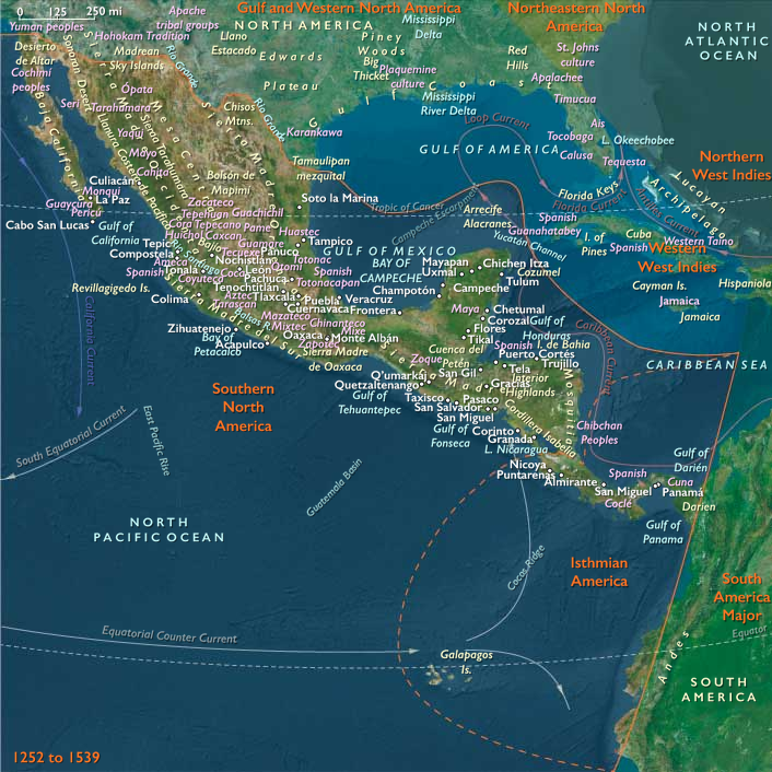
Middle America (1396–1539 CE)
Isthmian Crossroads, Mesoamerican States, and the First Atlantic Conquests
Geographic Definition of Middle America
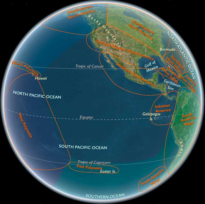
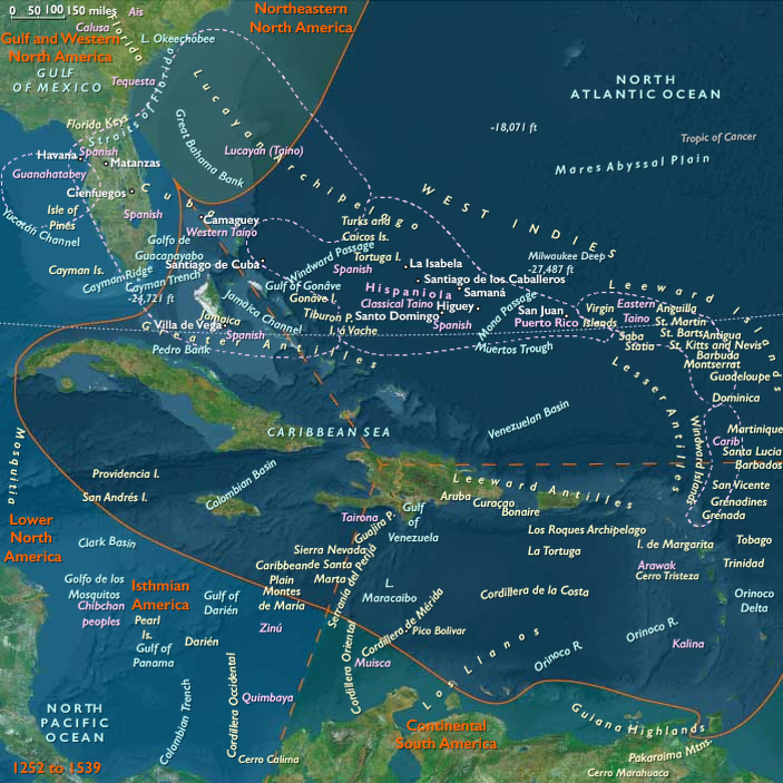
Middle America encompasses Isthmanian America—Costa Rica, Panama, the San Andrés Archipelago, the Galápagos Islands, and the Darién of Colombia with the Cape lands of Ecuador—and Southern North America—Mexico, Guatemala, Belize, Honduras, El Salvador, and Nicaragua.
Anchors include the Valley of Mexico, the Yucatán Peninsula, the Chiapas–Guatemalan cordillera, the Cordillera Central of Panama–Costa Rica, the Darién Gap, the Gulf of Panama, and the Pacific outliers of the Galápagos. Bounded by South America Major to the south (beginning beyond the Darién and Ecuador’s cape lands), this narrow continental hinge joined the Caribbean and Pacific, making it one of the most strategic corridors in the Americas.
Geography & Environmental Framework
The early Little Ice Age modestly cooled highlands while preserving tropical rainfall regimes.
Caribbean slopes remained humid; Pacific faces saw sharper dry seasons. Highland basins—from the Valley of Mexico to Antigua Guatemala—supported dense populations, while lowland coasts and floodplains favored cacao groves, salt pans, and fishing settlements. Offshore, the Galápagos oscillated with El Niño, their upwellings feeding seabird and turtle populations even in the absence of permanent human settlement.
Climate & Environmental Shifts
-
Highlands: Shorter growing seasons and frost risk in the Basin of Mexico and Guatemalan plateaus tested maize at altitude, but terrace and irrigation systems buffered yields.
-
Lowlands: Periodic drought affected Maya lowlands; hurricanes struck Caribbean coasts episodically; torrential rains inundated the Darién and Pacific estuaries.
-
Galápagos: El Niño brought rainfall pulses and disrupted marine upwelling cycles, altering rookery success.
Despite variability, societies mitigated risk through waterworks, multicropping, storage, and exchange.
Societies & Subsistence
Mesoamerican States and City-Regions (Southern North America)
-
Central Mexico: The Mexica (Aztecs) dominated the Basin of Mexico, their capital Tenochtitlan anchored by chinampas (raised-field “floating” gardens) yielding maize, beans, squash, amaranth, chilies, and flowers. Tribute maize, cacao, and cotton flowed along calzadas and causeways; ward-based calpulli organized labor and land.
-
Maya realms: After Mayapán’s collapse, smaller Maya polities in Yucatán and the Chiapas–Guatemalanhighlands sustained milpa agriculture, terrace fields, cacao orchards, and coastal fisheries. City-temple complexes, ball courts, and market towns persisted in flexible political mosaics.
-
Pacific & Gulf coasts: Estuarine villages combined maize horticulture with salt-making, shellfishing, and long-distance trade.
Isthmian Chiefdoms and Riverine Worlds (Isthmanian America)
-
Panama & Costa Rica: Chibchan and Cueva chiefdoms farmed maize, manioc, and cacao; gold–copper metallurgy, polished stone axes, and cotton textiles marked status. Dispersed hamlets and river villages linked floodplain fields to coastal fisheries.
-
Darién & Ecuador’s capes: Stilt-house communities managed riverine farming, fishing, and trade in cotton, salt, and shell ornaments between Caribbean and Pacific.
-
San Andrés & Galápagos: The archipelagoes remained uninhabited—waypoints in ecological and, by the sixteenth century, nautical networks.
Technology & Material Culture
-
Architecture & waterworks: Pyramids, palaces, and tzompantli precincts in stone; chinampa hydraulic systems; highland terraces and canals; stilt houses in floodplains.
-
Crafts & records: Polychrome pottery, featherwork, turquoise mosaics, and bark-paper codices recorded ritual and dynastic history.
-
Metallurgy & textiles: Isthmian gold–copper alloys, jade and shell ornaments; cotton weaving across lowlands and highlands.
-
Weapons & tools: Atlatl, obsidian blades, bows, shields; dugout canoes for coasting and river travel.
Movement & Interaction Corridors
-
Overland isthmus trails: Portage paths linked cacao zones, salt flats, and coasts—an overland bridge between the Caribbean and Pacific.
-
Mesoamerican trade: Mexica pochteca moved obsidian, cacao, cloth, and feathers across tribute routes radiating from Tenochtitlan; Maya merchants trafficked salt, jade, and cotton between Yucatán, highlands, and coasts.
-
River and coastal canoes: Navigated the Usumacinta, Grijalva, Motagua, Chagres, and Tuira, and along both littorals.
-
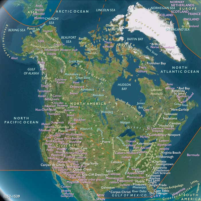
European intrusion: In 1510 Spaniards founded Santa María la Antigua del Darién; Vasco Núñez de Balboa crossed to the Pacific (1513). Hernán Cortés toppled the Mexica (1519–1521); Pedro de Alvarado and allies invaded Guatemala (1524); Nicaragua fell in the 1520s. From Panama, Pizarro and Almagro launched the Andean conquest.
Cultural & Symbolic Expressions
-
Mexica cosmology: Huitzilopochtli, Tlaloc, and solar order sustained imperial ritual—sacrifice renewed cosmic balance; the ball game dramatized conflict and renewal.
-
Maya traditions: Ancestor veneration, council houses (popol nah), divinatory almanacs, and painted codicesencoded history and prophecy.
-
Isthmian ritual: Shamanic healing, ancestor shrines, and prestige goldwork structured authority from Veraguasto Darién.
-
Across the isthmus and highlands, poetry, festivals, and mask-dances knit together cosmic cycles with communal time.
Environmental Adaptation & Resilience
-
Highlands: Terraces, irrigation, and chinampa intensification stabilized yields under frost and drought; surplus storage and tribute redistribution spread risk.
-
Lowlands & isthmus: Milpa rotations conserved soils; stilt houses mitigated floods; diversified diets—cacao, fish, palm fruits—balanced climate uncertainty.
-
Galápagos: Unpeopled ecosystems adapted to El Niño variability; rookeries persisted as part of a wider Pacific web.
Technology & Power Shifts (Conflict Dynamics)
The first Atlantic conquests cascaded through Middle America.
Cortés’s alliances—and epidemics—toppled the Mexica; Alvarado smashed highland Maya states; isthmian chiefdoms resisted but were overwhelmed by warfare, forced labor, and disease after 1510. From Panama, the bridge between seas became the staging ground for the Andean invasion. Yet pockets of autonomy survived in forests, mountains, and marshlands, where ritual and kin networks preserved identity beneath the new colonial order.
Transition (to 1540 CE)
By 1539 CE, Middle America stood transformed.
The Basin of Mexico was a Spanish capital; Guatemala and Nicaragua were colonial provinces; Panama had become the hinge of Spain’s oceanic empire. The Galápagos entered charts; the isthmus’s trails became imperial roads.
Still, Maya towns, Chibchan river villages, and refugee communities endured—maintaining languages, planting cycles, and ritual geographies in the interstices of conquest. Between two oceans, Middle America’s ancient corridors now carried a new world of ships, silver, and crosses—yet beneath them flowed the older currents of maize, cacao, and memory that would continue to shape the centuries to come.
Isthmian America (1396–1539 CE): Crossroads of Continents and Spanish Intrusion
Geographic & Environmental Context
The subregion of Isthmian America includes Costa Rica, Panama, the Galápagos Islands, the San Andrés Archipelago, and the northeastern edge of South America (the Darién of Colombia and the capes of Ecuador). Anchors included the Cordillera Central of Panama and Costa Rica, the Darién Gap, the coasts of the Gulf of Panama, and the Pacific outliers of the Galápagos. This narrow isthmus bound together Pacific and Caribbean, making it one of the most strategic corridors in the Americas.
Climate & Environmental Shifts
The Little Ice Age brought modest cooling but retained high rainfall across most of the isthmus. The Caribbean side experienced humid equatorial rains, while Pacific slopes endured a sharper dry season. The Galápagos were subject to El Niño cycles, alternately increasing rainfall and disrupting marine upwellings, affecting seabird and turtle populations. Hurricanes rarely reached the region, but torrential rains and flooding in the Darién constrained settlement.
Subsistence & Settlement
-
Panama and Costa Rica: Populated by Chibchan- and Cueva-speaking peoples who practiced maize, manioc, and cacao cultivation, combined with fishing, hunting, and foraging. Villages ranged from dispersed hamlets to larger chiefdom centers.
-
Darién: Supported riverine farming and fishing societies, with villages on raised platforms in flood-prone areas.
-
Capes of Ecuador: Hosted coastal farmers and fishers who traded cotton, salt, and shell ornaments.
-
Galápagos and San Andrés Archipelago: Uninhabited, though the Galápagos may have been visited intermittently by seafarers from Ecuador or northern Peru for turtles and fish.
Technology & Material Culture
Local crafts included polished stone axes, gold ornaments, and ceramics. Chibchan metallurgy blended hammered gold with copper alloys. Cacao served as both food and currency. Wooden dugout canoes carried people and goods between river mouths and along coasts. Shell beads, cotton cloth, and feather ornaments circulated through regional exchange.
Movement & Interaction Corridors
-
Canoes plied the Caribbean and Pacific coasts, linking river mouths and estuaries.
-
Trails across the Isthmus connected cacao-producing zones with salt flats, creating a vital overland passage between seas.
-
The Galápagos lay beyond normal voyaging networks but were ecologically connected by seabird migrations and turtle rookeries.
-
In 1510, Spaniards founded Santa María la Antigua del Darién, the first enduring European town on the mainland. From there, Vasco Núñez de Balboa crossed the Isthmus in 1513, becoming the first European to view the Pacific Ocean.
-
Expeditions under Francisco Pizarro and Diego de Almagro launched from Panama toward Peru in the 1520s and 1530s.
Cultural & Symbolic Expressions
Indigenous cosmologies emphasized ancestor veneration, shamanism, and sacred landscapes tied to rivers and mountains. Gold ornaments embodied prestige and ritual power. Spanish missionaries imposed crosses and chapels, though Indigenous rituals endured in villages and forests. Oral traditions preserved memory of migrations, river spirits, and ancestral origins.
Environmental Adaptation & Resilience
Communities adapted to flooding with stilt houses, diversified diets through riverine fishing and farming, and used cacao and trade networks to spread risk. In the Galápagos, seabirds and turtles exploited shifting upwellings and El Niño variability, sustaining unpeopled but vibrant ecosystems.
Transition
By 1539 CE, Isthmian America had become the launching point of Spanish conquest across the Andes and Pacific. Indigenous communities persisted in Costa Rica, Panama, and the Darién, though epidemics and violence had already begun devastating populations. The Galápagos remained uninhabited but entered Spanish charts. This narrow, strategic corridor—long an Indigenous crossroads—had become the hinge of Spain’s oceanic empire.
The native Taíno people before the arrival of Christopher Columbus in 1492 had populated the island that they call Quisqueya (mother of all lands) and Ayiti (land of high mountains), and which Columbus later names Hispaniola, including the territory of today's Republic of Haiti.
At this time, the island's territory consists of five chiefdoms: Marién, Maguá, Maguana, Jaragua, and Higüey These are ruled respectively by caciques (chiefs) Guacanagarix, Guarionex, Caonabo, Bohechío, and Cayacoa.
Bartholomew Columbus had founded a settlement on the site of today’s Santo Domingo and named it La Nueva Isabela, after the earlier settlement in the north named after the Queen of Spain, Isabella I.
It had been renamed "Santo Domingo" in 1495, in honor of Saint Dominic.
Santo Domingo will come to be known as the "Gateway to the Caribbean" and the chief town in Hispaniola from this point forward.
Expeditions that lead to Ponce de León's colonization of Puerto Rico, Diego Velázquez de Cuéllar's colonization of Cuba, Hernando Cortes' conquest of Mexico, and Vasco Núñez de Balboa's sighting of the Pacific Ocean will all be all launched from Santo Domingo.
The Spanish crown, aware that the Portuguese crown has sent Vasco da Gama off to India, finally authorizes Christopher Columbus to make a third voyage.
Despite difficulties in recruiting a crew, Columbus leaves with six ships from Sanlúcar, Spain, on May 30, 1498, for his third trip to the New World.
Three of the ships head directly for Hispaniola with much-needed supplies, while Columbus will take the other three in an exploration of what might lie to the south of the Caribbean islands he had already visited, including a hope-for passage to continental Asia.
Columbus leads his fleet to the Portuguese island of Porto Santo, his wife's native land.
He then sails to ...
...nearby Madeira and spends some time there with the Portuguese captain João Gonçalves da Camara, before sailing to the Canary Islands and Cape Verde.
In crossing the Atlantic in 1498, Columbus discovers that the angle between North as indicated by a magnetic compass and North as measured by the position of the pole star changes with his position (a phenomenon now known as "compass variation").
He will later use his previous measurements of the compass variation to adjust his reckoning.