Related Events
Filter results
Showing 10 events out of 2451 total
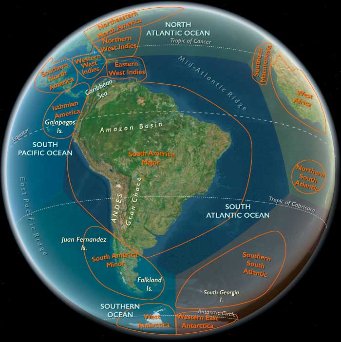
One twelfth of the Earth encompasses most of the South American continent, Puerto Rico, the Lesser Antilles, and the majority of Hispaniola—including southeastern Haiti and all but the northern coast of the Dominican Republic. This region, designated South America and the Eastern Isles, explicitly excludes Patagonia.
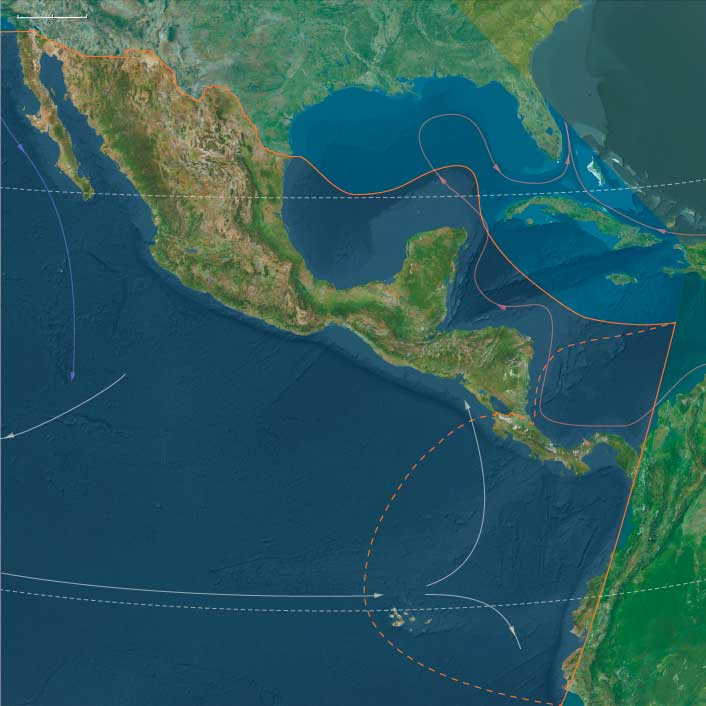
The northwestern boundary separates Panama, the southernmost country of Central America, from Colombia.
Within this world are the entirety of Venezuela, Guyana, Suriname, French Guiana, Brazil, Uruguay, Bolivia, and Peru. Argentina and Chile also belong largely to this region, though their sparsely populated southern reaches—Patagonia—are part of the subcontinent.
HistoryAtlas contains 2,652 entries for South America and the Eastern Isles from the Paleolithic period to 1899.
Narrow results by searching for a word or phrase or select from one or more of a dozen filters.
The West Indies (49,293–28,578 BCE): Upper Pleistocene I — Exposed Banks, Reef Arcs, and Island Worlds Without People
Geographic and Environmental Context
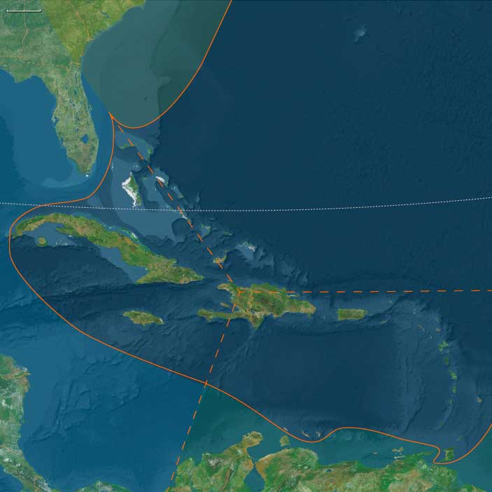
During the late Pleistocene, the West Indian archipelagos—stretching from the Bahama banks to Trinidad—were vast, emergent shelves divided into three natural subregions that would later become cultural zones: the Northern, Eastern, and Western West Indies.
-
The Northern West Indies comprised the Bahamas and Turks & Caicos banks and the northern coast of Hispaniola.
Sea levels ~100 m lower than today fused many of the present islands into broad limestone plains dotted with sinkholes and dune fields. The Cibao Valley and the Massif du Nord of Hispaniola formed the rugged southern margin of this shelf sea. -
The Eastern West Indies traced a long volcanic and carbonate arc from Puerto Rico and the Virgin Islands through the Lesser Antilles to Trinidad & Tobago, where the chain met the South American shelf.
Active volcanoes alternated with uplifted reef terraces and deep inter-island channels shaped by the northeast trades. -
The Western West Indies included Cuba, Jamaica, the Cayman Ridge, and western Hispaniola, flanked by the deep Cayman Trench and the Windward Passage.
Here, broad banks and narrow straits created a labyrinth of shelves, slopes, and enclosed lagoons fringed by coral and seagrass ecosystems.
These three subregions were already differentiated by geology and oceanography: the Northern banks were broad, flat, and porous; the Eastern arc steep and windward; the Western ridge mountainous and trench-bound. Together they formed the tropical hinge between the Atlantic and Caribbean basins—an archipelago before humanity, alive only with reefs, birds, and tides.
Climate and Environmental Shifts
The interval coincided with the approach to the Last Glacial Maximum, producing climatic contrasts across latitude and elevation:
-
Sea level fall of 90–110 m exposed vast carbonate platforms in the Bahamas and Caicos and broadened coastal plains around Cuba and Hispaniola.
-
Trade winds intensified as global temperature gradients sharpened, driving upwelling and enhancing nutrient flows along windward coasts.
-
Cooler sea-surface temperatures slowed coral accretion but favored calcareous algae, sponges, and mollusks, maintaining high marine productivity.
-
Periodic northers and dry seasons reduced rainfall, particularly over the northern and western islands, while volcanic highlands in the east retained moist forests and orographic rainfall.
The result was a gradient from arid limestone plains in the north to humid volcanic slopes in the east, already anticipating the ecological zones that would later support very different island societies.
Biotic Assemblages and Ecological Structure
With no humans yet present, the Pleistocene West Indies were laboratories of insular evolution:
-
Seabirds dominated: vast rookeries of boobies, frigatebirds, shearwaters, and petrels nested on cliffs and dunes from the Bahamas to the Grenadines.
-
Reptiles and amphibians were diverse, including large lizards and ground-dwelling tortoises on the larger banks.
-
Mammals were limited to endemic rodents and small insectivores; ground sloths and monkeys persisted on Cuba and Hispaniola into later millennia.
-
Marine ecosystems—reef flats, turtle-nesting beaches, mangrove-lined lagoons—functioned at full productivity, unaltered by hunting or fire.
-
Beneath the islands, freshwater lenses formed within porous limestones, supporting vegetation pockets and stabilizing the water table.
These pristine ecologies, organized by rainfall and ocean currents rather than human movement, set the template for all later biological and cultural differentiation in the Caribbean.
Movement and Interaction Corridors
Although uninhabited, the region was threaded by powerful oceanic highways that would later shape both migration and commerce:
-
The North Equatorial Current and its offshoot, the Florida Current, swept westward across the Lesser Antilles and northward through the Bahamas toward the Gulf Stream.
-
Countercurrents and eddies along the Caribbean side of the arc distributed larvae, seeds, and drifting vegetation between islands, knitting their ecosystems together.
-
These same pathways would eventually become the maritime corridors of human voyaging; in this epoch, they served only seabirds and sea turtles, tracing the routes that future canoes would follow.
Cultural and Symbolic Dimensions
No human symbolic system had yet entered this landscape, yet the environment itself encoded rhythms and structures that later peoples would mythologize: the circularity of atolls, the seasonal pulse of trade winds, the nesting cycles of seabirds, the periodic flooding and drying of lagoons.
These were the physical archetypes of later Caribbean cosmologies—worlds of tide and return, absence and reemergence.
Environmental Adaptation and Resilience
In biological terms, the archipelago functioned as a self-balancing triad:
-
Northern carbonate banks acted as vast nurseries for marine life, their freshwater lenses and seagrass meadows stabilizing regional nutrient budgets.
-
Eastern volcanic islands provided vertical zonation—reef, mangrove, forest—that buffered storms and erosion.
-
Western highlands generated sediment and nutrients feeding neighboring shelves.
Interconnected by wind and current, these systems maintained equilibrium without external disturbance. Each island was autonomous yet ecologically interdependent—an early analogue of the inter-island diversity that would later underpin cultural resilience in the peopled Caribbean.
Transition Toward the Last Glacial Maximum
By 28,578 BCE, the West Indies were an archipelago of abundance awaiting discovery.
Emergent banks and volcanic ridges, swept by steady trades, supported some of the most productive reef and seabird ecosystems on Earth.
No human footprints yet marked their dunes, but the stage was set: broad shelves for future navigation, fertile soils for cultivation, and ecological gradients for diversification.
In this epoch, the Caribbean existed as a network of natural worlds, poised—like the other realms of The Twelve Worlds—to become human worlds when the seas rose again.
Eastern West Indies (49,293–28,578 BCE) Upper Pleistocene I — Arc Volcanoes, Reef Slopes, and Windward Shelves (No People)
Geographic and Environmental Context
Eastern West Indies includes eastern Haiti and most of the Dominican Republic (excluding the northern fringe), Puerto Rico, the Virgin Islands, the Lesser Antilles (Anguilla → Aruba), and Trinidad & Tobago
Anchors: Vega Real–Santo Domingo valleys; Puerto Rico (Cordillera Central & coastal plains); Virgin Islands passes; Leewards/Windwards (Guadeloupe–Dominica–Martinique–St. Lucia–Barbados–St. Vincent–Grenada–Aruba); Trinidad & Tobago at the Orinoco gate.
Climate & Environmental Shifts
-
LGM cooling; lower sea level expanded near-shore benches and cays.
Subsistence, Technology, Corridors, Symbolism — N/A.
Adaptation & Transition -
Pristine; high marine productivity, unpeopled.
South America (49,293 – 28,578 BCE): Upper Pleistocene I — Refugia, Shelves, and the Two Southern Worlds
Geographic & Environmental Context
Late-Pleistocene South America was not one world but two adjoining worlds that barely overlapped:
-
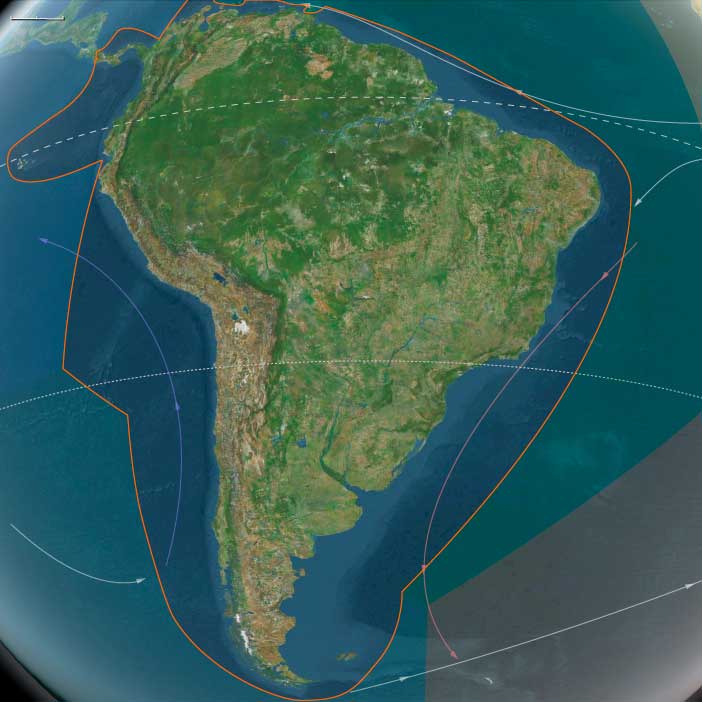
South America Major—from the Northern Andes (Quito–Cuzco–Titicaca–Altiplano) across the Amazon–Orinoco trunks, the Guianas Shield, and the Atlantic Brazil shelf, down through Paraguay–Uruguay–northern Argentina to northern Chile—was a continent of depressed cloud belts, fragmented rainforests, and broadened coastal plains.
-
South America Minor—Patagonia, Tierra del Fuego, and the Magellan–Beagle archipelagos—was an ice-marginal realm of fjords, loess steppe, and shelf banks along two oceans, largely unpeopled at this time.
These natural subregions looked outward more than inward: South America Major was knit to the Pacific and Amazonian basins; South America Minor leaned into the Southern Ocean and subantarctic winds. Their contrasts anchor The Twelve Worlds claim that “region” is a loose envelope—the living units are the subregions.
Climate and Environmental Shifts
The interval spans the build-up to the Last Glacial Maximum:
-
Andes & Altiplano: Temperatures were ~3–7 °C lower; glaciers expanded on high cordilleras; puna–páramo belts shifted downslope; springs and rock-shelter margins persisted.
-
Amazon/Guianas: Rainforest contracted into riparian and montane refugia, separated by savanna corridors; evapotranspiration fell; seasonality sharpened.
-
Atlantic Brazil shelf: Sea level ~100 m below modern exposed broad strand-plains; estuaries and deltas migrated seaward.
-
Atacama & high basins: Hyper-arid, cold plateaus with oasis springs and small lagoons.
-
Patagonia–Fuegia: Strong westerlies, permafrost or seasonal frost on the interior steppe; Cordilleran icefields calved into fjords; outer shelves widened on both coasts.
Heinrich/Dansgaard–Oeschger pulses toggled the continent between slightly wetter interstadials (refugia expand) and drier stadials (savannization and ice advance).
Lifeways and Settlement Patterns
Human presence before ~30 ka is debated. If present in this window, occupations were sparse and refugium-tethered; robust, widespread sites appear later, during deglaciation. The likely pattern:
-
South America Major
• Coasts (Pacific and Atlantic Brazil): Opportunistic foraging in upwelling coves and exposed strand-plains—shellfish, fish, seabirds—with short-stay dune or beach-ridge camps.
• Riparian lowlands (Amazon–Orinoco): Small groups anchored to gallery forests and levees—fish, turtles, capybara, supplemented by deer/peccary and palm fruits.
• Andean foothills & basins: Rock-shelter use near perennial springs; small-game, rodents, camelids at high elevations; wild tubers and chenopods along wet margins.
• Atacama oases: Patchy use of springlines and saline lagoons where available. -
South America Minor
• Likely unoccupied this early. Though kelp-forest corridors and rich fjord/shore ecologies existed (shellfish, pinnipeds, seabirds), sustained use is later (post-LGM, >14.5 ka north of the zone at Monte Verde).
Across the continent, potential foragers would have practiced short-radius mobility between water-secure nodes: coves ⇄ levees ⇄ springs ⇄ rock shelters.
Technology and Material Culture
Toolkits, where present, fit late Middle/early Upper Paleolithic expectations:
-
Stone: expedient flake–blade industries in quartz/quartzite and local cherts; retouched scrapers, burins, backed pieces late.
-
Organic: bone awls/points, digging sticks, nets/cordage (poorly preserved).
-
Pigment & ornament: ochre for body/adhesive use; simple beads (shell/seed) in later parts of the span are plausible.
These reflect light, portable technologies optimized for riparian and springline mobility, not heavy residential investment.
Movement and Interaction Corridors
Even with low population density, the continent’s natural corridors were already set:
-
Pacific littoral “kelp highway”: cove-to-cove reconnaissance along upwelling margins (Peru–N. Chile).
-
Andean valley strings: spring/rock-shelter chains linking puna to foothills.
-
Amazon–Orinoco trunks: Solimões–Madeira–Xingu–Tapajós–Negro and Orinoco–Casiquiare provided levee driftways and portage nodes.
-
Atlantic strandlines: broad Brazilian shelf plains connected estuaries and lagoon belts.
In South America Minor, the Magellan–Beagle coasts and wide shelf banks were ecological scaffolding for the later maritime florescence.
Cultural and Symbolic Expressions
If present in this span, symbolic behaviors would mirror the global Upper Paleolithic repertoire at low intensity: ochre use, hearth structuring, simple ornament caches in shelters. The richest, unequivocal material appears after the interval, as deglaciation improves site survivorship and territory size.
Environmental Adaptation and Resilience
The operating logic of the age was refugium tethering:
-
Water-secure nodes—gallery forests, springlines, upwelling coves—anchored seasonal rounds.
-
Broad portfolios—aquatic + terrestrial—buffered aridity and cold snaps.
-
Topographic stacking (coast ↔ foothill ↔ puna; levee ↔ terra firme) created short-range substitutes when one niche failed.
In South America Minor, kelp forests, guanaco steppe, and shelf banks formed the “later-use” safety net awaiting Holocene colonists.
Transition Toward Deglaciation
By 28,578 BCE, Andean ice began its slow retreat, rainforest corridors poised to reconnect, and coastal/riverine pathways to improve:
-
South America Major was primed for the unequivocal Late Pleistocene/Early Holocene occupations—shell-midden coasts, levee hamlets, puna caravan trails—that will define its next chapter.
-
South America Minor held its ecological stage set—fjords, archipelagos, and kelp lanes—for the post-LGM maritime foragers who would turn the far south into a canoe world.
In short, the continent already displayed the dual structure central to The Twelve Worlds: a peopled northern–central theater of refugia and corridors beside an unpeopled southern theater of ready-made ecologies—two neighboring worlds whose destinies would diverge as the ice let go.
South America Major (49,293–28,578 BCE)
South America Major includes Colombia (except Darién), Venezuela, the Guianas, Brazil, Ecuador (excluding the Capelands), Peru, Bolivia, Paraguay, Uruguay, northern Argentina, northern Chile.
Anchors: Northern Andes (Quito–Cuzco–Titicaca–Altiplano), Amazon Basin (Solimões–Madeira–Xingu–Tapajós–Marajó), Orinoco–Llanos, Atlantic Brazil coastal shelf, Guianas shield, Atacama oases.
Geographic & Environmental Context
-
Andes: extensive glaciation on high cordilleras; puna and páramo belts depressed downslope.
-
Amazon/Guianas: rainforest contracted into riparian and montane refugia, with intervening savanna corridors.
-
Atlantic shelf: sea level ~100 m lower exposed broad coastal plains; estuaries migrated seaward.
-
Atacama/Altiplano: cold, hyper-arid plateaus; oasis springs persistent.
Climate & Environmental Shifts
-
Last Glacial Maximum (LGM): cooler (~3–7 °C lower), drier interiors; stronger seasonality; widespread glaciation in the Central Andes; reduced Amazonian evapotranspiration.
-
Heinrich/D-O oscillations toggled between slightly wetter interstadials (refugia expand) and drier stadials (savannization).
Subsistence & Settlement
-
Human presence before ~30 ka is debated (claims in eastern Brazil and Andean foothills exist but are contested). If present, foragers would have favored riparian refugia, coastal upwelling zones, and montane spring belts.
-
Likeliest robust occupations in the later part of this window: coastal foraging (shellfish, fish, seabirds), riparian hunting (deer, peccary, capybara), and puna/basin small-game procurement.
Technology & Material Culture
-
Late Middle/early Upper Paleolithic flake–blade industries; expedient quartz/quartzite; bone awls/points; ochre pigments.
-
Portable organic technologies (nets, digging sticks) likely but poorly preserved.
Movement & Interaction Corridors
-
Pacific littoral (upwelling coves, dune-sheltered landings), Andean valley strings (springs/rock shelters), Amazonian trunk rivers (Solimões–Madeira–Xingu–Tapajós), Orinoco–Casiquiare links to the Negro–Amazon.
Cultural & Symbolic Expressions
-
If present, ochre and bead use, hearth structuring, and rock-shelter ritual spaces would mirror broader Upper Paleolithic patterns.
Environmental Adaptation & Resilience
-
Refugium strategy: tethering to evergreen gallery forests, springlines, and productive coasts; broad-spectrum aquatic + terrestrial foraging buffered aridity.
Transition
-
As deglaciation accelerates, rainforest corridors re-connect, Andean ice withdraws, and coastal/riverine pathways improve — enabling the unequivocal Late Pleistocene–Early Holocene occupations that follow.
Pedra Furada is the most controversial of the excavated prehistoric settlements in the Americas, indicating a human presence there as early as 50,000 BCE.
Pedra Furada ("drilled rock") is an important collection of over eight hundred archaeological sites and rock paintings in Brazil that suggest a human presence prior to the arrival of Clovis people in North America.
The discoveries are the subject of debate as they apparently contradict the "Clovis first" view for humans in the Americas, or short chronology theory, with the first movement beyond Alaska into the New World occurring no earlier than fifteen thousand to seventen thousand years ago, followed by successive waves of immigrants.
Pedra Furada provides arguments for the proponents of the long chronology theory, which states that the first group of people entered the hemisphere at a much earlier date, possibly twenty one thousand to forty thousand ears ago, with a much later mass secondary wave of immigrants.
Genetic studies of indigenous peoples have concluded that the "colonizing founders" of the Americas emerged from a single-source ancestral population that evolved in isolation, likely in Beringia.
The isolation in Beringia might have lasted ten thousand to twenty thousand years.
Age estimates based on Y-chromosome micro-satellite place diversity of the American Haplogroup Q1a3a (Y-DNA) at around ten thousand to fifteen thousand years ago.
This does not address if there were any previous failed colonization attempts by other genetic groups, which could be represented by those settling the Pedra Furada site, as genetic testing can only address current population ancestral heritage.
West Indies (28,577 – 7,822 BCE): Upper Pleistocene II → Early Holocene — Deglacial Shores, Mangrove Margins, and the First Island Stopovers
Geographic & Environmental Context
Spanning the Lucayan (Outer Bahamas) and Turks & Caicos banks, the Greater Antillean north coast (north Haiti’s Cap-Haïtien–Massif du Nord and the Cibao–Puerto Plata–Santiago corridor), the Puerto Rico–Virgin arc, the Lesser Antilles (Anguilla → Aruba), and Trinidad & Tobago at the Orinoco gate, the West Indies entered the Early Holocene as a necklace of rising reefs and widening lagoons.
As postglacial seas climbed ~60–80 m toward near-modern levels, exposed carbonate benches on the Bahama and Caicos platforms flooded into back-reef lagoons cut by new tidal passes; mangrove skirts thickened on leeward rims. Along northern Hispaniola, faulted ranges (Massif du Nord) shed sediments into incising Cibao rivers, building fertile fans against an enlarging shelf.
Across the eastern (Hispaniola–Puerto Rico–Lesser Antilles) and western (Cuba–Jamaica–Caymans–Gonâve) arcs, rocky promontories framed new embayments, while Trinidad & Tobago stood as the western hinge between island and continent. The Bahama–Caicos platforms remained vast, low, and storm-swept—physically inviting but thin-soiled and freshwater-poor.
Climate & Environmental Shifts
-
Bølling–Allerød (c. 14.7–12.9 ka): Regional seas warmed and coasts moistened; coral growth accelerated, reef flats aggraded toward sea level; mangroves colonized freshly flooded margins.
-
Younger Dryas (c. 12.9–11.7 ka): A short, cool–dry reversal lowered effective moisture and tempered reef accretion; dunes reactivated and lagoons periodically breached under stronger storms.
-
Early Holocene (post-11.7 ka): Monsoonal stability returned; trade-wind regimes regularized swell and rainfall; back-reef and mangrove systems stabilized, setting the physical template for later settlement.
Subsistence & Settlement
Occupation was sparse and episodic, with strongest signals at north-coast Hispaniola and Trinidad & Tobago; most outer banks and smaller islands (e.g., Turks & Caicos, Bahamas, many Lesser Antilles) show, at most, transient landfalls without durable villages.
-
Northern West Indies (Lucayan–Turks & Caicos–north Hispaniola):
• Hispaniola (north coast/Cibao): Preceramic Archaic foragers likely established semi-recurrent river-mouth camps, exploiting sturgeon-like fishes, reef and lagoon fish, mollusks, waterfowl, and deer/boar/ibex analogues in nearby foothills; shell scatters and simple hearths hint at feasting episodes.
• Bahamas & Turks/ Caicos: Cays and bank edges served as canoe stops and opportunistic foraging grounds (conch, turtles, seabirds); freshwater scarcity and storm-prone strandplains precluded stable occupation. -
Eastern West Indies (Hispaniola E., Puerto Rico, Virgin & Lesser Antilles, Trinidad & Tobago):
Seasonal shore stations formed at lagoon mouths and coves, especially where mangrove channels and fringe reefs concentrated resources. Trinidad & Tobago, tight to the Orinoco outflow and rich in estuarine fish, manatees, and turtles, were probable gateway nodes for ephemeral camps and knowledge transfer between mainland and islands. -
Western West Indies (Cuba–Jamaica–Caymans–W. Hispaniola):
Deglacial pass formation (e.g., Windward Passage, Jamaica Channel) created short-hop routes. Forager groups from the Greater Antilles likely made intermittent use of north-Cuba and Tortuga–Gonâve shorelines for marine harvests and lithic forays, leaving light, discontinuous scatters rather than permanent villages.
Technology & Material Culture
A preceramic, highly mobile toolkit prevailed:
-
Flaked stone: simple cores, expedient flakes, backed bladelets, scrapers for butchery and wood-working.
-
Bone tools: points, gorges, barbs for fish and turtle capture; awls/needles for skin and cordage work.
-
Watercraft: rafts and early dugout/dug-plank craft inferred from cross-channel movements and bank-edge stopovers.
-
Ornaments: shell beads and drilled teeth appear in coastal contexts; ochre used in body/ritual marking.
Movement & Interaction Corridors
The archipelago functioned as a stepping-stone seaway:
-
Hispaniola’s north coast as a launch/landfall interface with protected inlets and nearby freshwater.
-
Turks & Caicos and Bahama banks as seasonal corridors, utilized in calm-season windows, but largely uninhabited.
-
Orinoco–Trinidad–Lesser Antilles as a western Atlantic gateway, enabling episodic east–west drift and directed canoeing.
-
Windward Passage / Jamaica Channel as tentative links into western arcs (Cuba–Jamaica–Caymans), primarily for opportunistic forays.
Cultural & Symbolic Expressions
Where occupation occurred, waterfront places became mnemonic anchors:
-
Shell accumulations mark communal harvests and feasts at river mouths and coves, inscribing early claims to landing places.
-
Simple ornaments in coastal sites imply emergent identities and ties across shores.
-
In the absence of sustained settlement on the banks and many outer isles, natural rhythms—turtle crawls, seabird rookeries, seasonal fish runs—formed the ‘calendar’ of place.
Environmental Adaptation & Resilience
Foragers balanced littoral and riverine portfolios to ride climatic swings:
-
Mangrove-fringe shellfish and reef fishes buffered against cool/dry spells; riverine fish and riparian game underwrote lean seasons.
-
Mobility and short-stay landfalls mitigated storm risk on low, water-poor banks.
-
Knowledge of passes, currents, and bank hydrology—the seeds of later navigational traditions—was itself an adaptive asset.
Long-Term Significance
By 7,822 BCE, the West Indies remained lightly and unevenly touched by people: north-coast Hispaniola sustained semi-recurrent Archaic camps, Trinidad & Tobago functioned as a continental bridge, and the Bahama–Caicos–Lesser Antilles served mainly as episodic stopovers.
Yet the physical groundwork was laid—back-reef lagoons, mangrove larders, and bank-edge routes—for the later Ceramic-age colonization of the archipelago. The region’s defining pattern was already in motion: mobility across an aquatic landscape, with estuaries and reefs as granaries and coves as memory-sites that would guide the great peopling to come.
Eastern West Indies (28,577–7,822 BCE) Upper Pleistocene II — Deglaciation & Lagoon Growth (Sparse/Episodic Use)
Geographic and Environmental Context
Eastern West Indies includes eastern Haiti and most of the Dominican Republic (excluding the northern fringe), Puerto Rico, the Virgin Islands, the Lesser Antilles (Anguilla → Aruba), and Trinidad & Tobago
Anchors: Vega Real–Santo Domingo valleys; Puerto Rico (Cordillera Central & coastal plains); Virgin Islands passes; Leewards/Windwards (Guadeloupe–Dominica–Martinique–St. Lucia–Barbados–St. Vincent–Grenada–Aruba); Trinidad & Tobago at the Orinoco gate.
Climate & Environmental Shifts
-
Warming flooded benches into lagoons; mangroves expanded.
Subsistence & Settlement
-
Regional Archaic foragers likely reached Windwards/Leewards and Trinidad for seasonal shellfish–fish camps; Puerto Rico/Dominican east saw episodic foraging.
Technology & Corridors
-
Preceramic tools; canoe/raft coastal lanes via Orinoco → Trinidad → Lesser Antilles.
Symbolism & Adaptation
-
Shell-heap feasting; mobility buffered storms.
Transition
-
A stepping-stone archipelago primed for lasting settlement.
South America (28,577 – 7,822 BCE): Upper Pleistocene II → Early Holocene — Deglaciation, Reconnected Refugia, and Littoral Gateways
Geographic & Environmental Context
From the Quito–Cuzco–Titicaca–Altiplano to the Orinoco–Llanos, across the Amazon (Solimões–Madeira–Xingu–Tapajós–Marajó) and the Guianas Shield, and along the still-broadened Atlantic Brazil shelf and the upwelling coasts of Peru–northern Chile, South America entered the Early Holocene as a continent of rising mountains and rising seas.
In the south, South America Minor—Patagonia south of the Río Negro/Río Grande, the Strait of Magellan–Beagle Channel, Tierra del Fuego, and the Falkland/Malvinas–Juan Fernández outliers—saw Cordilleran icewithdraw into high cirques, carving fjord labyrinths west of the Andes and leaving proglacial lakes and steppe plateaus to the east.
Postglacial sea-level rise, still ~60–80 m below modern early in the period, flooded coastal benches into ria-like embayments and back-reef lagoons, particularly along Atlantic Brazil and the Caribbean margins, even as the Humboldt upwelling sustained kelp and shell-rich coves on the Pacific side.
Climate & Environmental Shifts
-
Bølling–Allerød (c. 14.7–12.9 ka): Warmer, wetter pulses reforested Amazonian and Orinocan refugia, stitched by major river corridors; Andean hydroclimates stabilized as puna and páramo belts crept upslope. Along the Pacific rim, upwelling cells fueled rich nearshore webs; on the Atlantic side, a still-broad shelf supported expansive strandplains and lagoons.
-
Younger Dryas (c. 12.9–11.7 ka): A cool/dry setback narrowed forest corridors, invigorated steppe in leeward interiors, and heightened reliance on littoral and riverine proteins.
-
Early Holocene (post-11.7 ka): Monsoons strengthened; Amazonian gallery forests re-expanded and linked; Andean snowlines retreated; estuaries and lagoons from Marajó to Santa Catarina and along Peru–Atacamastabilized as sea level rose toward modern positions.
Subsistence & Settlement
By ~13–12 ka, humans were widely established from Pacific Peru to the Andean forelands and major lowland trunks; settlement was semi-recurrent and water-anchored, with strong coastal–river–valley coupling:
-
Pacific littoral (Peru–N. Chile): Coves within the Humboldt Current hosted intensive harvest of shellfish, rockfish, anchoveta, sea lions, seabirds, and seaweeds, likely via raft/dugout logistics along a proto “kelp highway.” Shell scatters and strandline hearths signal repeated use of the same landings.
-
Andean valleys & puna: Rock-shelter and terrace hamlets targeted deer, vicuña/guanaco, vizcacha and caviomorph rodents, and wild tubers; riparian stands (e.g., chenopods, amaranths) were increasingly curated and processed on grindstones. Seasonal rounds linked high-puna hunts to valley springs and alluvial plots.
-
Amazon–Orinoco lowlands & Guianas: Wet-season camps on natural levees exploited fish, turtles, caimans, capybara, and abundant palm fruits; varzea/igapó mosaics encouraged orchard-garden tending around hamlets. On the Guianas Shield, foragers navigated inselberg–savanna–gallery forest patchworks with broad-spectrum diets.
-
Atlantic Brazil strandplains: A still-wide coastal plain nurtured early shell-midden nuclei at estuary mouths and dune-lagoon fringes, where bivalves, crustaceans, finfish, and marine mammal remains attest to repeated feasting and aggregation.
-
South America Minor (Patagonia–Fuegia): Along the fjord and channel coasts, foragers exploited kelp-forest seams (mollusks, fish, sea mammals) and likely staged short canoe/raft crossings; east of the Andes, steppe camps organized around guanaco drives, rhea hunts, and lake-margin waterfowl.
Across the continent, communities tethered to refugial nodes—springs, levees, coves, and rock shelters—while maintaining seasonal mobility across adjacent ecozones.
Technology & Material Culture
Toolkits balanced expedient mobility with targeted specialization:
-
Lithics: pervasive microlithic flake–blade industries; backed bladelets, scrapers, burins; regional obsidian/siliceous networks in Andean forelands and Patagonian steppes.
-
Aquatic gear: bone gorges and harpoons, composite points, net floats/sinkers; stake-weirs and basket traps emergent on salmon-bearing and whitefish rivers by late in the period.
-
Processing tools: grindstones/querns in Andean and lowland contexts for seeds, tubers, and pigment; shell adzes in littoral zones.
-
Containers & clothing: organic carriers (gourds, bark, skin), early netting and twined bags; tailored hides; ochre for body/ritual use; shell/seed/teeth ornaments in burials and feast contexts.
Movement & Interaction Corridors
Deglaciation and rising seas reconfigured, but did not diminish, connectivity:
-
Pacific kelp-forest corridor: cove-to-cove and island-to-island movements along Peru–N. Chile’s productive littoral.
-
Andean valley strings: rock-shelter nodes at springs and passes (Cochabamba, Puna de Atacama, Cuzco–Titicaca arc) linked high–mid–low altitude resource zones.
-
Amazon–Orinoco trunks: Solimões–Madeira–Xingu–Tapajós–Negro–Orinoco served as driftways and portage chains, coupling previously isolated forest refugia.
-
Atlantic strandlines: broad Brazilian shore supported early along-shore movement between lagoon fisheries and stone/palm resources inland.
These braided pathways moved dried fish and meats, palm starch/oils, lithics, pigments, and stories, re-knitting the continent after the LGM.
Cultural & Symbolic Expressions
Water and stone framed early ritual landscapes:
-
Rock shelters in Andean and foreland belts preserved hearths, pigment floors, and engraved/painted panels, marking places of teaching, exchange, and ceremony.
-
Shell-mounds on Pacific and Atlantic coasts functioned as feast and ancestor markers, accumulating over generations at favored landings.
-
Ochred burials and personal adornments (shell/seed/teeth beads) bespeak lineage memory and emerging territoriality, often at river mouths, levees, and springs.
Environmental Adaptation & Resilience
Resilience rested on refugia-tethered, multi-sited portfolios:
-
Refugium anchoring (lagoons, levees, springs) ensured dependable access to water and food as climate oscillated.
-
Broad-spectrum diets—littoral proteins paired with riparian and forest fare—buffered interannual variability, especially through the Younger Dryas cool/dry interval.
-
Seasonal scheduling across coast–valley–puna and river–terra firme–floodplain gradients spread risk; early orchard/patch management around camps enhanced reliability.
-
Storage of smoked fish and meat, roasted seeds/tubers, and rendered oils sustained longer stays and supported semisedentism.
Long-Term Significance
By 7,822 BCE, deglaciated Andean valleys, re-connected Amazon–Orinoco forests, and stabilizing littorals sustained semi-recurrent camp landscapes and nascent shell-midden nodes.
In the south-cone, dual kelp-edge and steppe economies were firmly in place, poised for the canoe-borne traditions of the Fuegian channels.
Across South America, the operating code of the coming Holocene was already legible: water-anchored, broad-spectrum subsistence; mobility braided to refugial anchoring; early plant tending; food storage; and ritualized claims to the enduring places that made life secure.
South America Major (28,577–7,822 BCE) | Upper Pleistocene II: Deglaciation, Refugia Reconnection, and Littoral Gateways
South America Major includes all regions north of the Río Negro: Colombia (except Darién), Venezuela, the Guianas, Brazil, Ecuador (excluding the Ecuadorian Capelands, which belong to Isthmian America), Peru, Bolivia, Paraguay, Uruguay, northern Argentina, and northern Chile.
Anchors: the Northern Andes (Quito–Cuzco–Titicaca–Altiplano), Amazon Basin (Solimões–Madeira–Xingu–Tapajós–Marajó), Orinoco–Llanos, the Atlantic Brazil shelf/coast (including sambaqui coasts), the Guianas Shield, and Atacama oases and salars (northern Chile).
-
Andean glaciers receded from late LGM maxima; puna and páramo belts rose upslope.
-
Amazon/Guianas: fragmented rainforest refugia reconnected along major trunks (Solimões, Madeira, Xingu, Tapajós).
-
Pacific littoral (Peru/ N. Chile): upwelling zones built shell- and kelp-rich coves; Atlantic Brazil shelf still broader than today.
-
Orinoco–Llanos: wetlands and gallery forests expanded in interstadials.
Climate & Environmental Shifts
-
Bølling–Allerød (14.7–12.9 ka): warmer/ wetter pulses reforested lowlands and stabilized Andean valley hydrology.
-
Younger Dryas (12.9–11.7 ka): cool/dry reversal; forest corridors pinched; littoral protein became critical.
-
Early Holocene (after 11.7 ka): warmth returned; rainfall increased, rivers bloomed.
Subsistence & Settlement
-
Secure, widespread human presence by ~13–12 ka across Pacific Peru, Andean foothills, and riverine lowlands:
-
Pacific coves (Peru/N. Chile): intensive shellfish, fish, seabirds; strandings; sea-plant harvesting (kelp, algae).
-
Andean valleys: deer, camelids (vicuña/guanaco in high puna), rodents, wild tubers; riparian plants.
-
Amazon/Orinoco: fish, turtles, capybara; palm fruits; small-game; wet-season camps on natural levees.
-
-
Guianas Shield: mixed forest-savanna foraging on inselbergs and gallery forests.
Technology & Material Culture
-
Microlithic flake–blade industries; bone gorges/harpoons; shell adzes in littoral zones; grindstones in Andean/lowland seed processing.
-
Ochre for body/ritual use; shell/seed ornaments.
Movement & Interaction Corridors
-
Pacific coastal “kelp highway”: cove-to-cove canoe/raft mobility;
-
Andean valley strings: springs/rock-shelter chains;
-
Amazon–Orinoco trunks + levee ridges: seasonal canoe drift and portage;
-
Atlantic Brazil strandlines: early shell-midden nuclei.
Cultural & Symbolic Expressions
-
Early rock-shelter ritual spaces in Andean/foothill belts; structured hearths; ochred burials.
-
Coastal shell-mounds served as feast/ancestor markers.
Environmental Adaptation & Resilience
-
Refugium tethering (riverine, littoral, and valley springs) + broad-spectrum diets reduced risk; seasonal scheduling across ecozones buffered the Younger Dryas.
Transition
By 7,822 BCE, deglaciated valleys, reconnected forests, and productive coasts supported semi-recurrent landscapes of camps and shell-midden nodes, setting the stage for semi-sedentary Holocene economies.