The Indian Ocean Lands
Related Events
Showing 10 events out of 1086 total
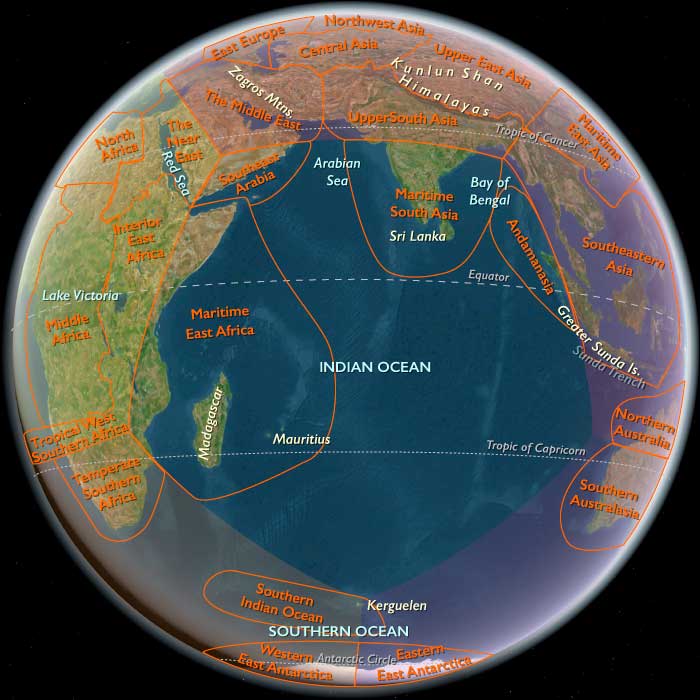
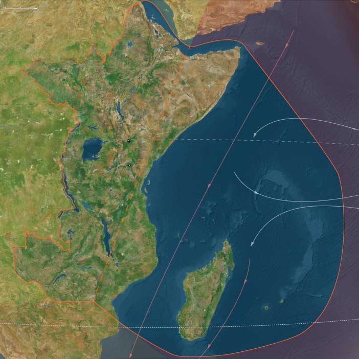
The Indian Ocean World, one of the twelve divisions of the Earth, is centered on the Indian Ocean and encompasses Madagascar, several small island groups, Maritime East Africa, Southeastern Arabia, Southern India, Sri Lanka, and Aceh—the northernmost tip of Sumatra. Its southernmost point is Kerguelen Island.
To the north of Madagascar, the island nations of the Comoros and the Seychelles are situated in the western Indian Ocean, while Mauritius lies to the east of the great island.
On the African mainland, the region includes portions of Mozambique, Malawi, Tanzania, Kenya, and Somalia, all of which also have cultural and historical ties to Afroasia.
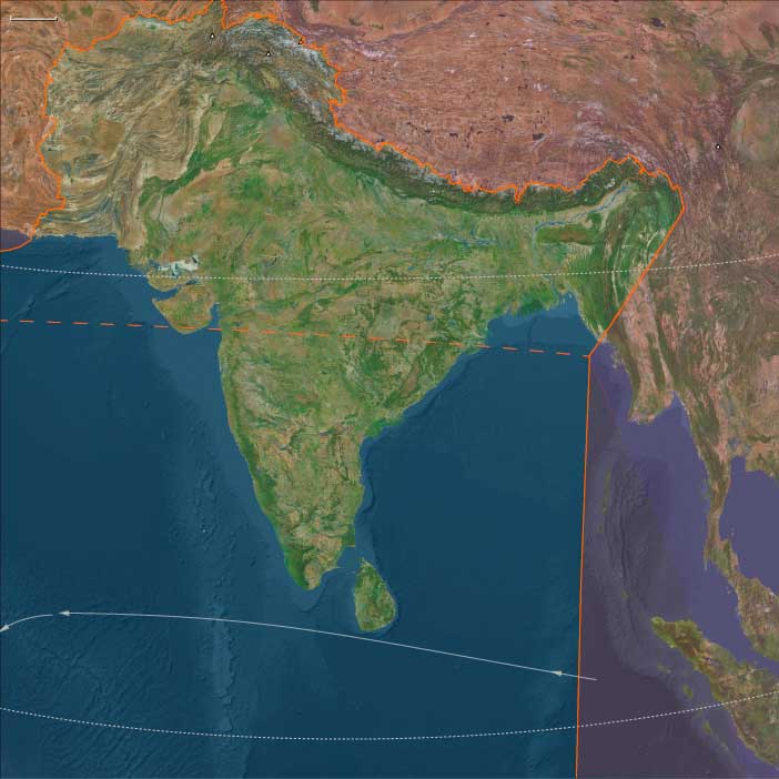
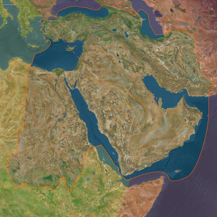
The Arabian nations of Yemen and Oman face the heart of the Indian Ocean World, with their division aligning with the traditional boundary separating North India from South India and Sri Lanka.
To the west of Southern India, the Maldives form a prominent island chain within this maritime world.
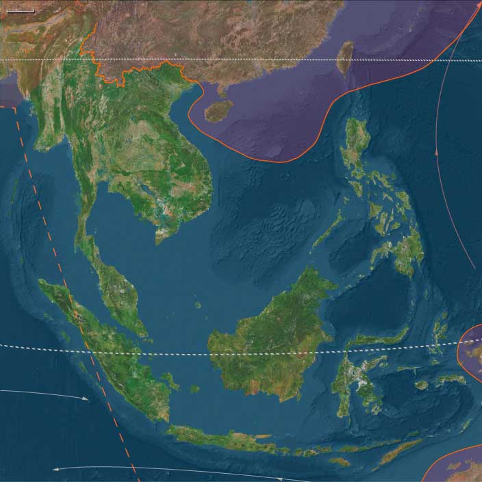
Along the northeastern boundary, only Aceh, the northwesternmost tip of Sumatra, belongs to the Indian Ocean World, distinguishing it from the rest of the Indonesian archipelago.
HistoryAtlas contains 1,059 entries for the Indian Ocean World from the Paleolithic period to 1899.
Narrow results by searching for a word or phrase or select from one or more of a dozen filters.
Primitive humans first migrate to the Indian subcontinent between 400,000 and 200,000 BCE; some of them possibly sail to southern India from eastern Africa.
The Moderns are taller, more slender, and less muscular than the Neanderthals, with whom they share—perhaps uneasily—the Earth.
Though their brains are smaller in overall size, they are heavier in the forebrain, a difference that may allow for more abstract thought and the development of complex speech.
Yet, the inner world of the Neanderthals remains a mystery—no one knows the depths of their thoughts or how they truly expressed them.
Modern humans learn to modulate voice into audible oral speech in the period beginning around 70,000 BCE; this is a development apparently not accomplished by other archaic hominids and one peculiar to our species.
Some also learn at this time to count beyond “one, two, and many.”
The descendants of the immigrants to West Asia who had remained in the south (or taken the southern route) had spread generation by generation around the coast of Arabia and the Iranian plateau until they reached India.
One of the groups that had gone north (east Asians were the second group) had ventured inland and radiated to Europe, eventually displacing the Neanderthals.
They had also radiated to India from Central Asia.
The former group headed along the southeast coast of Asia, reaching Australia between fifty-five thousand and thirty thousand years ago, with most estimates placing it about forty-six thousand to forty-one thousand years ago.
Sea level is much lower during this time, and most of Maritime Southeast Asia is one land mass known as the lost continent of Sunda.
The settlers probably continued on the coastal route southeast until they reached the series of straits between Sunda and Sahul, the continental land mass that was made up of present-day Australia and New Guinea.
The widest gaps are on the Weber Line and are at least ninety kilometers wide, indicating that settlers had knowledge of seafaring skills.
Archaic humans such as Homo erectus never reached Australia.
If these dates are correct, Australia was populated up to ten thousand years before Europe.
This is possible because humans avoided the colder regions of the North favoring the warmer tropical regions to which they were adapted given their African homeland.
Another piece of evidence favoring human occupation in Australia is that about forty-six thousand years ago, all large mammals weighing more than one hundred kilograms suddenly became extinct.
The new settlers were likely to be responsible for this extinction.
Many of the animals may have been accustomed to living without predators and become docile and vulnerable to attack (as will occur later in the Americas).
The small population of moderns had spread from the Near East to South Asia by fifty thousand years ago, and on to Australia by forty thousand years ago, Homo sapiens for the first time colonizing territory never reached by Homo erectus.
It has been estimated that from a population of two thousand to five thousand individuals in Africa, only a small group, possibly as few as one hundred and fifty to one thousand people, crossed the Red Sea.
Of all the lineages present in Africa only the female descendants of one lineage, mtDNA haplogroup L3, are found outside Africa.
Had there been several migrations one would expect descendants of more than one lineage to be found outside Africa.
L3's female descendants, the M and N haplogroup lineages, are found in very low frequencies in Africa (although haplogroup M1 is very ancient and diversified in North and Northeast Africa) and appear to be recent arrivals.
A possible explanation is that these mutations occurred in East Africa shortly before the exodus and, by the founder effect, became the dominant haplogroups after the exodus from Africa.
Alternatively, the mutations may have arisen shortly after the exodus from Africa.
Some genetic evidence points to migrations out of Africa along two routes.
However, other studies suggest that only a few people left Africa in a single migration that went on to populate the rest of the world, based in the fact that only descents of L3 are found outside Africa.
From that settlement, some others point to the possibility of several waves of expansion.
The Arrival of Early Modern Humans in Eurasia
Homo sapiens sapiens, the same physical type as modern humans, appeared in various regions by at least 50,000 BCE. These Early European Modern Humans (EEMH), formerly known as Cro-Magnon peoples, represent the first anatomically modern humans in Europe.
Migration into Eurasia
- Early modern humans entered Eurasia via the Arabian Peninsula approximately 60,000 years ago.
- One group rapidly settled coastal areas around the Indian Ocean, expanding into South and Southeast Asia.
- Another group migrated north, reaching the steppes of Central Asia and eventually spreading into Europe.
Coexistence with Neanderthals
- Neanderthals and modern humans coexisted across Europe and western Asia for thousands of years.
- Evidence suggests that interactions may have been peaceful, with possible cultural exchanges.
Interbreeding and Genetic Legacy
- Genetic studies indicate that Neanderthals and modern humans interbred occasionally, with non-African populations today carrying traces of Neanderthal DNA.
- However, there is no strong evidence supporting the existence of true Neanderthal-modern hybrids as a distinct population. Instead, interbreeding events were limited, contributing only small genetic fragments to the modern human genome.
The arrival of modern humans in Eurasia marked a significant turning point, eventually leading to the replacement of Neanderthals, though traces of their genetic legacy remain in human populations today.
Southeast Asia (49,293 – 28,578 BCE): Upper Pleistocene I — Sundaland Continents, Island Worlds, and the Dawn of Rock Art
Geographic & Environmental Context
At the height of the Late Pleistocene glacial world, Southeast Asia presented two contrasting landscapes — the broad, continental plains of Sundaland and the fragmented islands of Wallacea and Andamanasia — together forming one of the planet’s richest and most diverse human realms.
-
Sundaland: With sea level 50–120 meters below present, the exposed shelf united Sumatra, Java, Borneo, and the Malay Peninsula into a single subcontinent threaded by enormous rivers (paleo-Mekong, Mahakam, Kapuas, Brantas, Musi). Its coastlines stretched hundreds of kilometers beyond today’s shores, forming wide savanna–forest mosaics, mangrove-fringed estuaries, and lagoons teeming with life.
-
Wallacea: Beyond the drowned shelf lay Sulawesi, the Moluccas, Banda, Halmahera, Timor, and the Philippines—a chain of volcanic and limestone islands divided by deep channels marking the Wallace Line. These crossings demanded deliberate navigation and early maritime technology.
-
Andamanasia: To the northwest, the Andaman and Nicobar Islands, together with Aceh’s offshore arcs (Simeulue–Nias–Mentawai), Preparis–Coco, and the Cocos (Keeling) Islands, formed isolated forested refugia edging the exposed Sunda shelf. Their reefs, mangroves, and turtle beaches stood largely unpeopled but ecologically robust.
This region, straddling the equatorial monsoon belt, offered every possible habitat: mountains, caves, mangroves, coral reefs, and inland plains—each a seasonal hub for late Pleistocene foragers.
Climate & Environmental Shifts
-
Early Period (49–40 ka): Alternating warm–wet and cool–dry pulses governed by orbital forcing and monsoon strength. Forests waxed and waned, while lower sea levels extended savannas across exposed shelf flats.
-
Mid–Late Period (40–30 ka): Cooler, drier glacial trend; rivers incised deeper valleys, and interior lakes and wetlands shrank. On Sundaland, open woodlands and grasslands expanded, while the monsoon weakened and the dry season lengthened.
-
Approach to the LGM (after 30 ka): Intensified aridity inland; coastal productivity remained high as cold upwelling zones enriched fisheries. In Wallacea and Andamanasia, rainfall persisted in volcanic uplands and cloud-forest refuges, sustaining biodiversity through the glacial maximum.
These climatic oscillations required mobility and ecological flexibility, drawing humans toward coasts and river corridors where food remained predictable.
Human Societies and Lifeways
Sundaland Foragers
-
Population & Organization: Small, mobile bands of hunter–fishers numbering a few dozen individuals, moving seasonally between river valleys, forests, and estuaries.
-
Subsistence:
• Terrestrial: red deer, wild cattle (banteng), pigs, and forest birds; fruit, tubers, nuts, and honey.
• Aquatic: riverine fish, turtles, mollusks, and estuarine shellfish.
• Fire management maintained patchy mosaics that attracted game and improved travel routes. -
Settlements: Open camps along paleo-rivers and karstic caves (Lang Rongrien, Niah, Tabon) served as wet- and dry-season bases.
Wallacean Islanders
-
Maritime Expansion:
Short but deliberate crossings linked Bali–Lombok, Sulawesi, the Moluccas, and the Philippines. Voyagers likely used bamboo rafts or dugout craft, already capable of island-hopping across swift straits. -
Economy:
Coastal and reef exploitation dominated: fish, shellfish, turtles, and seabirds; inland forests provided sago palms, fruits, and nuts. -
Symbolism:
The world’s earliest known figurative rock art—hand stencils and painted animals in Sulawesi and Borneo (≥40,000 BP)—emerged here, marking one of humanity’s earliest symbolic revolutions.
Andamanasian Refugia
-
Status: Probably uninhabited or sparsely visited; nearby shelf coasts were rich in mangroves, turtles, and seabirds.
-
Role: Served as ecological storehouses—dense forests and reefs sustaining species that would repopulate coastlines when sea levels rose.
Technology & Material Culture
Across the region, technological diversity mirrored environmental range:
-
Stone industries: Large flakes, blades, and denticulates; hafted spear points and knives. Toolkits adapted to mixed forest and aquatic settings.
-
Organic tools: Bone and shell awls, barbed points, and fish gorges; woven nets and basketry inferred from indirect evidence.
-
Pigment and ornament: Red ochre for body painting and adhesive binders; perforated shell, tooth, and bone beads as markers of identity and alliance.
-
Fire technology: Controlled burning reshaped landscapes for hunting and plant gathering.
-
Maritime engineering: Simple rafts or canoes allowed crossing of deep channels—among the earliest seafaring experiments on Earth.
Movement & Interaction Corridors
-
River Arteries: The paleo-Mekong, Mahakam, and Kapuas systems functioned as “interior highways,” linking uplands to the exposed shelf coastlines.
-
Maritime Crossings:
• Wallace Line passages—Bali–Lombok, Makassar Strait, Molucca gaps—connected hunter–gatherer populations despite fierce currents.
• Philippine corridors—Luzon–Visayas–Mindanao and the Sulu arc—fostered early trade in shell, pigment, and worked bone.
• Andaman–Nicobar chains paralleled the Sunda coastline, possibly sighted but not yet permanently occupied.
These overlapping networks formed the world’s earliest complex seascape of interaction, prefiguring Holocene navigation traditions.
Belief and Symbolism
Southeast Asian peoples by this time had developed a sophisticated symbolic world:
-
Cave and rock art in Sulawesi, Borneo, and Palawan reveal enduring mythic narratives—animals, hand stencils, and spirit figures linked to hunting and fertility.
-
Ochre rituals and bead ornaments signified personal and group identity.
-
Animistic cosmologies likely centered on water, rock, and ancestral spirits inhabiting caves, springs, and trees—beliefs that would echo in later Austronesian spiritual systems.
Environmental Adaptation & Resilience
Adaptation was rooted in mobility, flexibility, and knowledge sharing:
-
Ecological diversity—forests, coasts, savannas, and rivers—allowed resource substitution during climate downturns.
-
Fire and water mastery reshaped landscapes and improved predictability.
-
Distributed knowledge networks—oral mapping of water sources, seasonal winds, and fauna—anchored community resilience.
-
Littoral foraging provided a caloric safety net through the harshest glacial episodes.
These strategies ensured persistence through one of the most variable climatic regimes on Earth.
Long-Term Significance
By 28,578 BCE, Southeast Asia had achieved a remarkable cultural and ecological synthesis:
-
The Sundaland–Wallacea continuum fostered societies adept at both land-based and maritime living.
-
Rock art, ornamentation, and pigment use announced an enduring symbolic sophistication.
-
Island-hopping navigation and inter-band exchange forged the first Pacific seafaring tradition.
These foundations—broad-spectrum foraging, flexible mobility, and deeply symbolic worldviews—would underpin every later cultural transformation of the region, from Holocene coastal settlement to Neolithic agriculture and, millennia later, the great Austronesian voyaging dispersals that carried Southeast Asia’s legacy across the entire Pacific.