Atlantic Southwest Europe (909 BCE–819 CE): Atlantic…
909 BCE to 819 CE
Atlantic Southwest Europe (909 BCE–819 CE): Atlantic Hillforts, Roman Corridors, and the Reorganization of Northern Iberia
Geographic and Environmental Framework
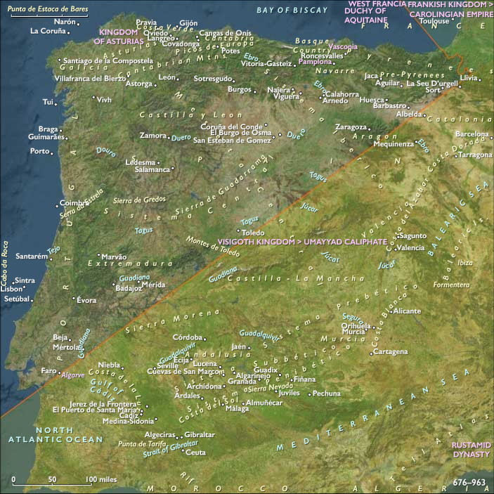
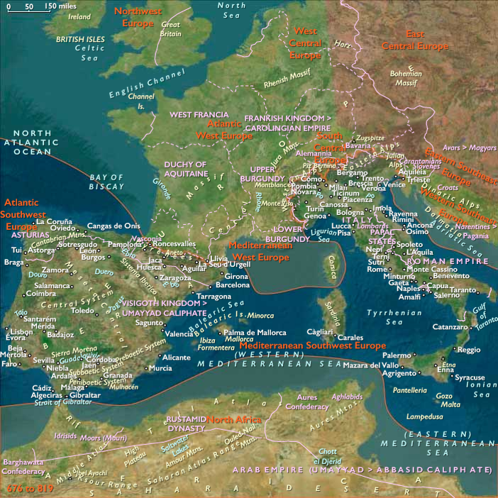
Atlantic Southwest Europe comprises central and northern Portugal, including Lisbon and the Sado estuary, together with northern and northwestern Spain: Galicia, Asturias, Cantabria, the Basque Country, western La Rioja, northwestern Navarre, the far western Spanish Pyrenees, nearly all of Castile and León apart from its southeastern portion, and northwestern Extremadura. Its southern boundary follows an imaginary line running northeastward from the Sado estuary to approximately 43.03476° N, 1.17208° W on the modern Franco-Spanish border.
The subregion contains several interlocking but sharply differentiated environmental systems. The deeply indented Galician coast and the estuaries of northern and central Portugal open toward the Atlantic, while the narrow Cantabrian coastal plain lies between the sea and steep mountains. The Minho, Lima, Cávado, Ave, Douro, Mondego, Tagus, and Sado drain westward into the Atlantic; the upper Ebro and its tributaries flow eastward through northern interior basins. The Cantabrian Mountains, Galician massifs, Portuguese uplands, western Pyrenees, and the northern and western edges of the Meseta divide humid coastal districts from colder uplands and more seasonally dry interior plains.
Oceanic rainfall supported oak, chestnut, birch, alder, hazel, and mixed woodland across much of the northwest and northern coast. River valleys, sheltered basins, and lower Portuguese districts supported increasingly extensive cereal fields, orchards, vineyards, and grazing lands. Mountain environments favored cattle, sheep, goats, seasonal movement, woodland exploitation, and dispersed settlement. Along the lower Douro, Mondego, Tagus, and Sado, Atlantic and Mediterranean ecological influences overlapped, producing more diverse agricultural landscapes than those of the wetter north.
These environmental contrasts prevented the region from developing as a single cultural or political unit. Instead, its history unfolded through repeated interactions among coast and interior, mountain and plateau, river valley and upland pasture, Atlantic exchange and Iberian overland movement. Political systems changed dramatically between 909 BCE and 819 CE, but rivers, passes, estuaries, forests, mineral zones, and agricultural basins remained the enduring organizers of settlement and communication.
Iron Age Agricultural Consolidation and Hillfort Landscapes
At the beginning of the epoch, communities across Atlantic Southwest Europe were reorganizing landscapes inherited from the Late Bronze Age. Small farming and pastoral settlements occupied river terraces, defensible spurs, fertile basins, and upland margins. Households cultivated cereals and legumes, managed cattle, sheep, goats, and pigs, gathered woodland resources, and moved livestock between lowland and upland pastures. Coastal communities supplemented agriculture with fishing, shellfish collection, salt production, and short-distance maritime travel.
Settlement patterns varied substantially. Across Galicia, northern Portugal, Asturias, and western León, hilltop and promontory settlements gradually became more numerous and more enduring. These communities formed the early foundations of what archaeologists call the Castro cultural landscape, but development was uneven: many early settlements remained modest, only lightly enclosed, and closely connected to surrounding fields, woodland, grazing land, and water sources. Mature stone-walled castros and larger fortified centers appeared only gradually and never replaced dispersed farms, hamlets, seasonal shelters, or open settlements throughout the entire northwest.
Elsewhere, communities along the upper Douro, western Meseta, upper Ebro, Basque valleys, and western Pyrenean approaches developed their own combinations of enclosed settlements, open villages, pastoral territories, and cultivated plains. Older burial mounds, standing stones, rock outcrops, springs, caves, and river crossings continued to structure social memory and ritual geography, although most were inherited monuments rather than newly constructed megalithic complexes.
Iron technology spread gradually through existing networks of exchange and local experimentation. It strengthened woodland clearance, cultivation, carpentry, metalworking, and warfare, while bronze remained important for ornaments, vessels, prestige objects, and ritual deposition. Metallurgical knowledge was especially significant in districts with access to gold, tin, copper, and iron. Yet most production remained embedded in household and community economies rather than concentrated in large specialized centers.
Regional Identities and Expanding Exchange
Between the sixth and third centuries BCE, population growth, agricultural expansion, craft production, and competition over land encouraged greater settlement nucleation in many districts. Some hillforts acquired stronger walls, more densely arranged houses, storage facilities, workshops, and gathering spaces. Larger settlements sometimes coordinated exchanges among smaller communities, but political authority generally remained distributed among local groups rather than concentrated in territorial states.
The communities later identified by Greek and Roman writers as Gallaeci, Astures, Cantabri, Lusitanians, Vettones, Vaccaei, Autrigones, Caristii, Varduli, Berones, and Vascones emerged from long processes of local development, interaction, political alliance, and outside classification. These identities should not be understood as fixed nations occupying sharply bounded territories. They represented overlapping linguistic, social, and political affiliations whose meaning changed as communities interacted with neighbors and, eventually, with Mediterranean empires.
Celtic languages and artistic traditions became influential across much of western and northern Iberia, but this transformation was not simply the result of a single mass migration. Mobility, intermarriage, warfare, elite emulation, technological exchange, and regional communication contributed to varied Celtic-speaking and culturally hybrid communities. The western Pyrenees, Basque valleys, and upper Ebro preserved distinct linguistic traditions while remaining connected to surrounding Iberian and trans-Pyrenean networks. Evidence from Iron Age Navarre demonstrates that these communities were neither isolated nor culturally static.
Atlantic maritime routes linked estuaries and coastal anchorages from the Sado and Tagus northward toward Galicia and the Bay of Biscay. Rivers connected those coastal routes to inland agricultural and mineral districts. Mediterranean goods and technologies reached the western façade through southern Iberian ports, overland exchange, and increasingly direct maritime contact. Imported pottery, wine containers, ornaments, glass, and metal objects were unevenly distributed and usually concentrated among coastal communities or local elites. Mediterranean exchange stimulated social differentiation in some districts, but it did not transform the whole region into a dependent extension of Phoenician or Carthaginian commerce.
Across the upper Ebro and interior plateau, routes linking the Atlantic façade, central Iberia, the Mediterranean, and passes through the western Pyrenees supported the movement of livestock, salt, grain, metals, pottery, and people. By the later Iron Age, some settlements became substantial regional centers, yet agricultural land, pasture, forest, and river access remained more important to everyday life than monumental civic architecture. The growth of larger fortified settlements was one element within a diverse settlement system rather than a universal progression toward urbanism.
Roman Conquest and the Reorganization of the Landscape
Roman intervention after the Second Punic War gradually brought the southern and interior portions of Atlantic Southwest Europe into the expanding Roman Republic. Conquest proceeded unevenly. Campaigns against Lusitanian and other western communities during the second century BCE were followed by prolonged military operations in the northwest and north. The Cantabrian Wars of 29–19 BCE completed formal Roman conquest, but incorporation involved negotiation with local elites, recruitment into auxiliary forces, relocation of some communities, taxation, and the adaptation of existing settlements as much as battlefield defeat.
Roman rule transformed regional connections more thoroughly than it erased local society. Roads crossed mountain passes, followed river valleys, and linked administrative towns, mining districts, military stations, ports, and agricultural basins. Bridges, way stations, ports, and secondary tracks strengthened movement between the Atlantic coast, Meseta, upper Ebro, and western Pyrenean corridors. Oiasso, near the mouth of the Bidasoa, connected the Bay of Biscay with inland routes between the Ebro basin and Pyrenean passes, illustrating the extent to which Romanization reached the Basque coastal and riverine landscape.
The most intensive extractive transformations occurred in the mineral-rich northwest. Gold mining in Galicia, Asturias, and León reshaped hillsides and water systems through channels, reservoirs, excavation, and large labor forces. Other districts supplied iron, copper, tin, stone, timber, salt, and agricultural produce. Mining settlements and military installations created new concentrations of population, but they remained dependent on surrounding forests, farms, pastures, and water networks.
Roman administration organized the region among several provinces, principally Lusitania, Tarraconensis, and later Gallaecia, without eliminating older regional distinctions. Cities such as Olisipo, Bracara Augusta, Lucus Augusti, Asturica Augusta, and other municipal centers became nodes of taxation, law, craft production, ritual, and trade. The road network tied these cities to smaller towns, roadside settlements, villas, mining communities, hillforts, ports, and rural estates.
Agriculture expanded in accessible valleys and plains. Wheat, barley, millet, legumes, vines, olives in suitable southern and sheltered districts, fruit trees, cattle, sheep, pigs, and horses supported mixed regional economies. Villas and larger estates became important, particularly near cities and productive corridors, but small farms and community-managed landscapes persisted. Watermills, presses, storage buildings, irrigation works, drainage systems, and improved roads increased production without producing a uniform Mediterranean estate landscape across the wetter north.
Coastal industries remained significant. Fisheries, saltworks, fish processing, timber use, and shipborne commerce linked Lisbon, northern Portuguese ports, Galician estuaries, the Cantabrian coast, and the Bay of Biscay to Gaul, Britain, North Africa, and Mediterranean markets. River navigation was most effective in lower reaches and estuaries; farther inland, pack animals, carts, and roads carried goods around rapids, steep valleys, and seasonal changes in water level.
Romanization was therefore a reorganization of connectivity rather than a simple replacement of indigenous life. Latin spread through administration, military service, markets, inscriptions, and urban institutions, while local languages, household forms, religious practices, and communal identities persisted unevenly. Hillforts were abandoned in some areas, transformed in others, and occasionally remained occupied alongside new lowland settlements.
Provincial Maturity, Rural Diversity, and Christian Expansion
During the first three centuries CE, Atlantic Southwest Europe became deeply integrated into the Roman imperial system. Roads, towns, mining districts, villas, ports, and rural markets created a connected but regionally varied provincial landscape. Local elites participated in municipal government and imperial administration, while citizenship, military service, taxation, and commerce linked rural communities to distant institutions.
Prosperity was not uniform. Mining intensity changed over time, some towns grew while others remained modest, and many mountain communities continued to depend on pastoralism, forest products, and local exchange. Roman material culture penetrated most strongly along major roads, river valleys, mining zones, ports, and administrative centers. More remote uplands often combined imported goods and Roman legal structures with older settlement rhythms.
Religious life was similarly layered. Roman civic cults, household rites, indigenous deities, sacred springs, mountain sanctuaries, and ancestral traditions coexisted. Christianity appeared gradually through towns, roads, ports, and social networks rather than spreading evenly from a single center. By the fourth century, bishoprics and Christian communities had become important in several cities, but the countryside remained religiously diverse. Christianization involved the adaptation of existing social spaces, cemeteries, estates, and local sacred geographies as well as the construction of churches.
The political crises of the third century disrupted long-distance commerce and imperial administration but did not produce uniform collapse. Some cities contracted, mining systems changed, and local production became more important. At the same time, roads, estates, ports, workshops, and market centers continued to operate. Rural settlements often reorganized rather than disappearing, while local landholders, municipal elites, military officials, and bishops assumed greater responsibility for taxation, protection, arbitration, and resource management.
Late Roman Regionalization and the Suebic Kingdom
During the fourth and fifth centuries, the landscape became increasingly regionalized. Large estates remained important, but they existed alongside villages, small farms, former hillfort sites, roadside settlements, ecclesiastical properties, and surviving urban communities. The transition from Roman to post-Roman society was not a straightforward replacement of slavery by feudalism. Enslaved people, tenants, dependents, free peasants, artisans, pastoralists, and landowners continued to occupy overlapping economic positions.
The arrival of Suebi, Vandals, and Alans in 409 CE accelerated political fragmentation. In the northwest, the Suebic Kingdom emerged in Gallaecia, centered principally on Galicia and northern Portugal. Its rulers did not construct an entirely new society upon Roman ruins. They governed through surviving cities, local aristocracies, military followings, bishops, taxation practices, rural estates, and negotiated relationships with regional communities. Archaeological evidence increasingly indicates substantial continuity in Galician settlement and local economic life despite episodes of warfare and political instability.
Braga became an important royal and ecclesiastical center, while other towns, river crossings, ports, and rural districts retained regional significance. Suebic authority was strongest in some areas and more indirect in others. Mountain zones, peripheral valleys, and the eastern parts of the subregion continued to be shaped by local powers and by interaction with the expanding Visigothic Kingdom.
Christian institutions matured during this period. Bishops organized councils, managed property, mediated political disputes, and linked towns with rural congregations. Monastic communities developed gradually and unevenly; they were not yet the vast, isolated complexes familiar from later medieval landscapes. Small churches, episcopal centers, estate chapels, cemeteries, hermitages, and modest religious communities formed a dispersed institutional network.
The conversion of the Suebi from Arian to Nicene Christianity during the sixth century strengthened links between royal authority and the regional church. After the Visigothic annexation of the Suebic kingdom in 585 CE, Galicia and northern Portugal became part of a broader Iberian monarchy, but former Suebic territories retained strong aristocratic, ecclesiastical, and regional identities.
Visigothic Integration and Persistent Local Landscapes
Under Visigothic rule, councils, law codes, episcopal administration, royal taxation, and aristocratic estates connected Atlantic Southwest Europe more closely to political centers elsewhere in Iberia. Yet the reach of royal authority varied. Northern mountains, Basque districts, the western Pyrenean approaches, and parts of the upper Ebro remained zones of negotiation, intermittent warfare, local autonomy, and cross-border interaction.
The countryside was not dominated by fortified feudal estates. Most inhabitants lived in villages, hamlets, farmsteads, pastoral settlements, and surviving small towns. Fields, vineyards, orchards, grazing lands, mills, woodland commons, fisheries, and local craft production sustained the regional economy. Roman roads and bridges remained important even where maintenance became more localized. Ports and estuaries continued to support modest exchange around the Atlantic façade and Bay of Biscay.
Christian institutions became more deeply embedded, but religious practice remained locally inflected. Churches were frequently small, communities dispersed, and many older seasonal, funerary, and landscape traditions persisted within Christian frameworks. Bishops and monasteries accumulated influence, but they shared authority with aristocratic households, village communities, local military leaders, and regional assemblies.
Islamic Conquest and Political Recomposition
The collapse of the Visigothic monarchy after 711 CE brought much of the subregion into contact with the expanding Umayyad Caliphate and the developing society of al-Andalus. Lisbon, the Tagus basin, central Portugal, northwestern Extremadura, much of the Duero valley, and parts of the upper Ebro entered Islamic political and fiscal networks. Conquest did not produce an immediate or uniform cultural break. Existing towns, estates, roads, agricultural communities, bishops, and local elites often continued under new arrangements of tribute, alliance, conversion, or negotiated submission.
Northern mountain districts were more difficult to control directly. In Asturias and adjoining Cantabrian territories, local leaders established an emerging Kingdom of Asturias during the eighth century. Covadonga later became a powerful symbol of Christian resistance, but the polity developed gradually from local mountain authority, Visigothic political traditions, aristocratic alliances, and the opportunities created by shifting Islamic power. It should not be imagined as immediately commanding all Galicia, Cantabria, the Basque Country, the Duero basin, or northern Portugal.
The Duero valley was neither completely emptied nor converted into a literal defensive desert. Political authority weakened in some districts, settlements shifted, and population density may have declined locally, but farming, herding, small communities, ecclesiastical sites, and regional exchange persisted. Recent scholarship emphasizes a complex zone containing local powers and communities rather than a simple vacant barrier between two unified opposing states.
Galicia, Asturias, Cantabria, the Basque districts, upper Ebro communities, and northern Portugal followed different trajectories. Some regions became tied to Asturian rulers; some negotiated with Muslim governors; some remained under strong local aristocracies; and others shifted repeatedly between spheres of influence. Basque and western Pyrenean communities participated in alliances and conflicts involving Asturias, al-Andalus, Frankish powers, and neighboring Ebro authorities without losing their distinct regional organization.
Across these political boundaries, the environmental economy endured. Cattle and sheep moved through upland pastures; cereals and vines occupied valleys and plateaus; forests supplied fuel, construction timber, forage, and woodland products; mills used streams; fisheries and saltworks operated along the coast; and estuaries remained gateways for local and longer-distance exchange. Political instability altered taxation, security, and the movement of elites more rapidly than it transformed the underlying ecological system.
Asturian Consolidation and Ecclesiastical Networks
By the late eighth and early ninth centuries, Asturian rulers extended their influence through parts of Galicia, Asturias, Cantabria, and the northern Meseta. Royal authority remained dependent on aristocratic households, local communities, bishops, monasteries, fortified refuges, river routes, and mountain passes. Courts and churches acquired greater symbolic importance, but they existed within a dispersed agrarian and pastoral landscape rather than an urbanized state.
Christian institutions provided continuity across changing political regimes. Bishoprics, small monasteries, churches, and religious estates preserved literacy, managed land, supported travelers, and mediated among local powers. Their influence grew through networks rather than through monumental architectural dominance. The reputed discovery of the tomb of Saint James at Compostela belongs to the closing years of the epoch. Its immediate regional importance should be acknowledged without projecting the enormous later Camino de Santiago backward into the early ninth century.
In the southern and eastern portions of the subregion, communities under Andalusi authority participated in Islamic fiscal, agricultural, commercial, and administrative systems. Muslim, Christian, and Jewish populations interacted through towns, markets, estates, roads, and river corridors. The frontier was not a single fortified line but a broad, shifting zone of tribute, raiding, diplomacy, settlement, and economic exchange.
Legacy of the Epoch
Between 909 BCE and 819 CE, Atlantic Southwest Europe was transformed from a mosaic of Iron Age farming, pastoral, coastal, and hillfort communities into a region divided among post-Roman and early medieval political systems. Yet its most enduring structures were environmental rather than dynastic.
The Atlantic coast and its estuaries sustained fisheries, salt production, maritime exchange, and sheltered settlement. The Minho, Douro, Mondego, Tagus, Sado, upper Ebro, and numerous smaller rivers connected agricultural basins with ports and inland routes. The Cantabrian Mountains, Galician uplands, western Meseta, Basque valleys, and western Pyrenees encouraged pastoral mobility, localized authority, and cultural resilience. Forests, fields, vineyards, orchards, mines, pastures, and waterways remained the foundation upon which every political system depended.
Iron Age hillfort networks, Roman roads and mining systems, provincial towns, villas, churches, Suebic and Visigothic institutions, Andalusi administration, and the emerging Asturian monarchy represented successive reorganizations of this enduring landscape. None entirely erased what preceded it. By 819 CE, Atlantic Southwest Europe had become a politically plural region in which Asturias, Galicia, northern Portugal, the Duero basin, the Basque territories, the upper Ebro, and the Andalusi-controlled south remained connected through inherited routes, shared ecological systems, and continuing movement across political boundaries.
The epoch’s central historical development was therefore not the inevitable rise of a Christian reconquest state. It was the long conversion of diverse Atlantic, mountain, riverine, and plateau landscapes into increasingly connected regional systems—first through Iron Age exchange, then Roman infrastructure, and finally the overlapping political and ecclesiastical networks of post-Roman Iberia.
Groups
Topics
Commodities
Regions
Southwest Europe
View →Subregions