Event
Eastern East Antarctica (1828–1971 CE): Discovery, Extraction,…
Eastern East Antarctica (1828–1971 CE): Discovery, Extraction, and Scientific Enclaves
Geographic Parameters
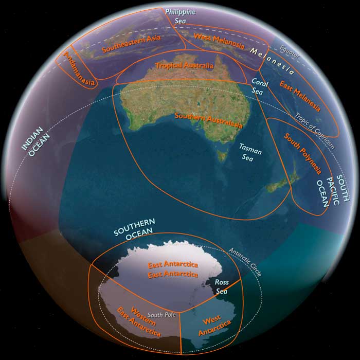
Eastern East Antarctica extended from 70°E to 170°W, encompassing the Amery Ice Shelf sector, the coastal regions later associated with the Australian Antarctic Territory and Adélie Land, the Totten Glacier and Aurora Basin systems, Wilkes Land, George V Land, and the vast interior plateau. Human access remained concentrated on rare coastal rock exposures, navigable summer waters, selected glacier routes, and a small number of inland traverses.
Discovery and Coastal Charting
The first principal transformation was direct observation. During the nineteenth century, French, American, British, and other expeditions sighted and charted portions of the eastern Antarctic coast. In 1840, the French expedition led by Jules Dumont d’Urville reached Adélie Land and made a brief landing on exposed coastal rock. During the same broad period, the United States Exploring Expedition under Charles Wilkes charted substantial stretches of the coast later associated with Wilkes Land.
These encounters converted conjectural geography into a partially observed continental margin. Discovery remained incomplete and contested: coastlines were often viewed from offshore through fog, snow, pack ice, and uncertain position fixing. Most of the interior remained wholly unknown.
Scientific Exploration and Territorial Claims
Twentieth-century expeditions introduced more sustained geographical and scientific work. Expeditions associated with Douglas Mawson surveyed parts of the coast and interior, combining mapping with meteorology, geology, magnetism, and biology. Sledging parties, wireless communication, and later aircraft expanded the range of observation.
France maintained its claim to Adélie Land, while Australia assumed authority over the much larger Australian Antarctic Territory. These claims were expressed through maps, proclamations, expedition records, flags, cairns, and eventually stations rather than continuous settlement. The continent remained almost entirely unoccupied.
Industrial Whaling
The most extensive human ecological impact occurred offshore. Steam-powered catcher vessels, explosive harpoons, factory ships, and modern processing enabled industrial whaling throughout Antarctic waters. Blue, fin, humpback, and other whales were killed in immense numbers during the first half of the twentieth century.
The removal of whales damaged a marine system extending far beyond any station or landing site. It demonstrated that Eastern East Antarctica could be profoundly affected by distant industrial networks even while its terrestrial landscape remained largely untouched.
Permanent Scientific Presence
After the Second World War, permanent research bases created the first enduring human enclaves. Australia established Mawson station in 1954 near the western portion of the subregion. The Soviet Union founded Mirny station in 1956 on the Queen Mary Land coast, and France established its permanent Adélie Land program, ultimately centered on Dumont d’Urville station.
These bases introduced prefabricated buildings, generators, fuel stores, radio masts, tracked vehicles, scientific instruments, small landing areas, and seasonal supply ships. Their physical footprints remained extremely limited. Each station occupied a minute coastal site surrounded by vast ice, rock, sea, and uninhabited interior.
International Science and Governance
The International Geophysical Year of 1957–1958 coordinated observations across Antarctica and encouraged multinational research in meteorology, glaciology, geophysics, seismology, magnetism, and atmospheric science. Aircraft and mechanized traverses revealed inland ice thickness, subglacial topography, and large-scale continental structure.
The Antarctic Treaty, signed in 1959 and entering into force in 1961, reserved Antarctica for peaceful purposes, protected scientific cooperation, and suspended rather than resolved disputes over sovereignty. National stations continued to represent state ambition, but they also became nodes within an international research system.
Environmental Continuity and Human Vulnerability
Despite improved technology, humans remained dependent on imported food, fuel, machinery, communications, and seasonal resupply. Blizzards, darkness, crevasses, sea ice, and mechanical failure restricted movement. Stations did not domesticate the continent; they created small artificial habitats within it.
Penguins, seals, seabirds, and marine ecosystems continued around these enclaves, although whaling had severely reduced major whale populations. Local station areas accumulated waste, tracks, fuel residues, and abandoned equipment, but most of the terrestrial subregion remained little disturbed.
Legacy of the Age
By 1971, Eastern East Antarctica had moved from total human isolation to limited and permanent scientific presence. Coastal charting, territorial claims, industrial whaling, aviation, radio, mechanized traverses, and research stations connected selected sites to the modern world. Yet the environment remained overwhelmingly dominant. Human activity occupied narrow maritime routes, tiny coastal compounds, and a few interior corridors, while ice, ocean, wind, darkness, and distance continued to govern almost the entire subregion.

-
{# Image navigates to the detail page; the magnifying-glass chip is the only Fancybox lightbox trigger (kept a separate sibling — anchors can't nest). #}
 Southern Oceania
World
Southern Oceania
World
-
{# Image navigates to the detail page; the magnifying-glass chip is the only Fancybox lightbox trigger (kept a separate sibling — anchors can't nest). #}
 Antarctica
Region
Antarctica
Region
-
{# Image navigates to the detail page; the magnifying-glass chip is the only Fancybox lightbox trigger (kept a separate sibling — anchors can't nest). #}
 Eastern East Antarctica
Subregion
Eastern East Antarctica
Subregion