Tropical West Southern Africa (1540–1683 CE): Salt…
1540 CE to 1683 CE
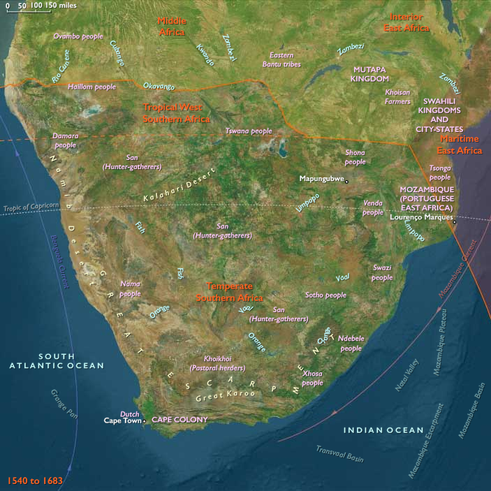
Tropical West Southern Africa (1540–1683 CE): Salt Pans, River Deltas, and the Web of Cattle and Trade
Geography & Environmental Context
Tropical West Southern Africa includes northern Namibia, northern Botswana, the Etosha Salt Pan, the Skeleton Coast, the Okavango Delta, the Caprivi Strip (Bwabwata National Park), and the Chobe River basin. Anchors include the Etosha Pan, a vast endorheic salt depression; the Okavango Delta, an inland wetland fed by rivers from Angola; the Chobe and Zambezi corridors that drain toward Victoria Falls; and the Skeleton Coast, with its foggy Atlantic littoral. The region is marked by sharp ecological contrasts: arid savannas and desert margins punctuated by riverine and wetland oases that sustained wildlife, herders, and cultivators alike.
Climate & Environmental Shifts
The Little Ice Age reached into the Kalahari margins with cooler, sometimes wetter, conditions. Rainfall was variable: the Okavango and Chobe basins offered reliable seasonal floods, while Etosha alternated between shallow saline lakes and barren crust. Drought years stressed cattle herds, while wet years expanded grazing and millet harvests. Coastal fogs along the Skeleton Coast provided scarce water but could not sustain agriculture. The combination of aridity and wetlands produced a landscape of both fragility and resilience.
Subsistence & Settlement
-
Agropastoral systems: Communities cultivated sorghum, millet, and beans in river valleys and delta margins, while cattle, goats, and sheep were the backbone of wealth and diet.
-
Pastoral frontiers: Herero-speaking groups (inland) emphasized cattle as both economic base and spiritual symbol, while hunter–gatherer San groups adapted flexibly to both savanna and desert margins through foraging and hunting.
-
Wetland lifeways: The Okavango Delta and Chobe River floodplains supported fishing, hippo hunting, and seasonal gardening; shifting settlements followed rising and receding waters.
-
Salt and trade: The Etosha Pan was a major source of salt, harvested and exchanged with neighboring communities.
-
Coastal settlements: The Skeleton Coast itself had no permanent farming populations, but seasonal San foragers exploited seals, fish, and stranded whales.
Technology & Material Culture
Stone and iron tools were both in use: iron hoes, spears, and arrowheads circulated via trade from metallurgical centers farther north. Cattle herding technologies (corrals, milking, leatherwork) were highly developed among Herero groups. Canoes and rafts were used in the Okavango channels, while woven baskets and pottery supported food storage. Beads, ostrich-shell jewelry, and decorated leather garments reflected both local craft and long-distance exchange.
Movement & Interaction Corridors
-
North–south corridors: Cattle, salt, and ivory moved southward toward the Kalahari, while beads, copper, and iron filtered down from Angola and the upper Zambezi.
-
Okavango–Caprivi–Chobe corridor: Rivers linked delta cultivators, fishers, and hunters into trade networks reaching the Zambezi.
-
Salt caravans: Etosha’s salt was exchanged widely, reaching Ovambo and Kavango groups and moving into cattle economies further south.
-
Coastal margins: Though inhospitable, the Skeleton Coast connected indirectly to Atlantic trade: Portuguese navigators knew its dangers but seldom landed; shipwreck survivors sometimes entered local oral memory.
Cultural & Symbolic Expressions
Cattle were central to Herero cosmology, wealth, and marriage exchanges; rituals honored ancestors through livestock sacrifice. San communities maintained rich traditions of rock painting and trance dance, recording animal migrations and spiritual encounters. Floodplain societies developed initiation ceremonies tied to the river cycles of Okavango and Chobe. Myths of spirits inhabiting pans, rivers, and desert fogs reflected the precarious balance between abundance and scarcity.
Environmental Adaptation & Resilience
-
Mobility: Pastoralists shifted herds to seasonal grazing between river valleys and uplands.
-
Diversity: Fishing, foraging, hunting, and gardening buffered famine during droughts.
-
Storage: Dried fish, salted meat, and stored grain preserved food across lean seasons.
-
Social insurance: Kin networks and cattle exchange spread risk during disasters.
-
Ecological knowledge: San foragers exploited tubers, melons, and wildlife in drylands, ensuring survival when herds and crops failed.
Political & Military Shocks
This subregion was beyond direct Portuguese control, though Angola’s colonies and missions lay to the northwest and Mozambique’s prazos to the northeast.
-
Herero–Ovambo relations: Emerging pastoral polities contested grazing and water rights, often through raiding and alliance-making.
-
Kavango and Caprivi: Chieftaincies along the Okavango managed trade in ivory and slaves feeding into markets further north and east.
-
Regional raiding: Captives, ivory, and cattle from the fringes of the Okavango–Zambezi corridor entered east African and Angolan trade circuits, foreshadowing deeper integration into global commerce.
Transition
Between 1540 and 1683, Tropical West Southern Africa was characterized by a balance of cattle economies, foraging traditions, and wetland horticulture, knit together by salt, ivory, and livestock exchanges. While European caravels skirted the Skeleton Coast, the region remained locally controlled, with power concentrated in cattle-rich Herero lineages, salt-trading Ovambo and Kavango groups, and riverine polities in the Caprivi–Chobe floodplains. Resilience rested on mobility and ecological knowledge, but the pull of ivory and captive trades toward Angola and Mozambique foreshadowed the subregion’s gradual incorporation into larger Atlantic and Indian Ocean networks.
Commodities
Subjects
Regions
Southern Africa
View →Subregions
