Southwest Europe (2637 – 910 BCE): Bronze …
Years: 2637BCE - 910BCE
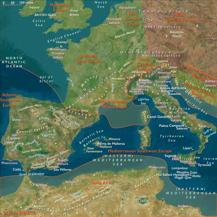
Southwest Europe (2637 – 910 BCE): Bronze and Early Iron — Maritime Hubs, Mountain Strongholds, and Continental Gateways
Regional Overview
In the Bronze and Early Iron Ages, Southwest Europe—embracing Italy, Iberia, and their island arcs—emerged as a web of agrarian valleys, fortified uplands, and seafaring coasts.
From Sardinia’s nuraghe towers to the Tagus and Po river plains, communities combined metalworking skill, maritime trade, and ancestral monumentality to form one of the most dynamic regions of Early Antiquity.
Its twin coasts—the Mediterranean and the Atlantic—linked Europe to Africa and the wider sea world, shaping networks that would persist for millennia.
Geography and Environment
Southwest Europe comprised two complementary environmental spheres:
-
the Mediterranean South, defined by dry summers, terraced hillsides, and island–coastal trade corridors (Italy, Sicily, Sardinia, Malta, and the Balearics);
-
the Atlantic West, a cooler, wetter realm of forested highlands, fertile valleys, and estuarine fisheries (northern Spain and Portugal).
Mountains such as the Apennines, Alps, and Cantabrians structured settlement; river corridors—the Po, Tagus, and Douro—carried grain, metal, and ideas between interior and sea.
Climate and Environmental Shifts
Holocene stability gradually yielded to modest arid pulses in the south and cooler intervals in the north.
Mediterranean drought cycles encouraged terracing and irrigation, while Atlantic rainfall sustained pasture and mixed farming.
Sea levels stabilized near modern positions, expanding coastal plains and harbors crucial to Bronze Age navigation.
Societies and Settlement Patterns
Mediterranean South – Maritime Cities and Island Polities
By 2000 BCE, farming villages across Italy, Sicily, and Iberia’s southeast coast evolved into complex chiefdoms anchored by copper and bronze production.
-
Sardinia constructed its nuraghe towers, massive stone fortresses that doubled as clan centers and territorial markers.
-
Malta’s megalithic temples—already ancient—remained pilgrimage foci; new fortified hamlets arose nearby.
-
Sicily and southern Italy thrived as copper–tin smelting and exchange hubs, trading with Aegean and North African ports.
Coastal agriculture—grain, olives, grapes—fed both local and export economies, while fishing and seafaring sustained daily life.
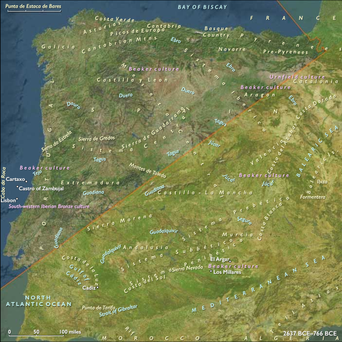
Atlantic West – River Valleys and Upland Forts
North of the Pyrenees, communities in Portugal and northern Spain combined mixed farming with metalworking.
Fortified hill settlements guarded passes and trade routes linking the Tagus, Douro, and Ebro valleys.
Megalithic tombs, stone circles, and barrows—reused from earlier epochs—remained ceremonial landmarks, symbolizing ancestral rights to land and resource zones.
Economy and Technology
Bronze metallurgy unified the region.
-
Copper from Sardinia, Cyprus, and Iberia met tin from western Iberia and Brittany to fuel trans-Mediterranean and trans-Atlantic exchange.
-
Agricultural surpluses, especially grain, wine, and oil, underwrote urban growth along river valleys.
-
In both subregions, terracing, irrigation, and transhumant herding maximized productivity.
-
Maritime technology advanced rapidly: sewn-plank and pegged boats navigated the Tyrrhenian and Iberian coasts, while Atlantic river craft managed inland freight.
Trade and Interaction Corridors
Southwest Europe occupied the hinge between three great exchange worlds:
-
The Mediterranean network, linking Italy and Iberia to Crete, Egypt, and the Levant through long-distance trade in metals, wine, and ceramics.
-
The Atlantic network, where estuarine ports of the Tagus and Douro connected with Brittany and the British Isles via amber and tin routes.
-
The inland corridors, through the Rhône–Alpine and Ebro–Meseta passes, uniting coastal polities with continental Europe’s Urnfield and Hallstatt horizons.
Cultural and Symbolic Expressions
Monumental architecture reflected both defense and devotion: nuraghe towers, tholos and hypogeum tombs, navetas in the Balearics, and stone sanctuaries along Iberian rivers.
Grave goods—bronze weapons, beads, amber, and decorated pottery—displayed widening social hierarchies and distant connections.
Artistic motifs—spirals, bulls, solar disks, marine creatures—linked cosmology to fertility, seafaring, and lineage memory.
Island and coastal rituals often centered on water sources and ancestral shrines, blending local myth with imported iconography.
Environmental Adaptation and Resilience
Flexibility defined survival strategies:
-
Mediterranean farmers balanced terraced cultivation with fishing and trade.
-
Atlantic herders moved seasonally between upland and lowland pastures.
-
Diversified subsistence—grains, vines, livestock, shellfish—buffered against drought or storm.
Community-scale storage systems and exchange reciprocity stabilized food supply, while shared sanctuaries reinforced cooperation across ecological zones.
Regional Synthesis and Long-Term Significance
By 910 BCE, Southwest Europe stood as a maritime and metallurgical crossroads.
Its Mediterranean islands and peninsulas connected to the Near Eastern trade sphere, while its Atlantic valleys and uplands reached toward Central Europe and the British Isles.
Bronze technology, monumental landscapes, and seafaring economies had transformed local villages into interconnected societies—the western gateway of the ancient world.
This foundation of agrarian stability, mineral wealth, and maritime connectivity would underpin the rise of later civilizations—from Etruscan Italy to the Iberian Tartessos and Phoenician Spain—that would dominate the first millennium BCE.
Groups
Topics
- Neolithic Europe
- Subboreal Period
- Early Bronze Age III (Near and Middle East)
- Abrolhos Transgression
- Early Bronze Age IV (Near and Middle East)
- 4.2 kiloyear BP aridification event
- Middle Bronze Age I (Near and Middle East)
- Rottnest Transgression
- Younger Subboreal Period
- Iron Age Europe
- Greek colonization, First
Commodoties
- Weapons
- Domestic animals
- Oils, gums, resins, and waxes
- Grains and produce
- Textiles
- Strategic metals
- Beer, wine, and spirits
Subjects
Regions
Subregions
Years: 2637BCE - 910BCE
Groups
Topics
- Neolithic Europe
- Subboreal Period
- Early Bronze Age III (Near and Middle East)
- Abrolhos Transgression
- Early Bronze Age IV (Near and Middle East)
- 4.2 kiloyear BP aridification event
- Middle Bronze Age I (Near and Middle East)
- Rottnest Transgression
- Younger Subboreal Period
- Iron Age Europe
- Greek colonization, First
Commodoties
- Weapons
- Domestic animals
- Oils, gums, resins, and waxes
- Grains and produce
- Textiles
- Strategic metals
- Beer, wine, and spirits
Subjects
Regions
Subregions