Southwest Europe (7,821 – 6,094 BCE): Early…
7821 BCE to 6094 BCE
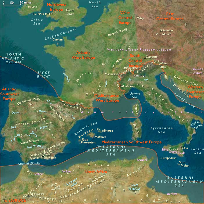
Southwest Europe (7,821 – 6,094 BCE): Early Holocene — Twin Seas, One Water-Bound World
Geographic & Environmental Context
Southwest Europe braided two great façades into a single coastal-river system:
-
Mediterranean Southwest Europe—the Guadalquivir–Ebro–Tiber–Po basins, Languedoc–Provence lagoons, Corsica–Sardinia–Sicily, and the Venetian lagoon—where drowned shelves became back-barrier basins under warm, reliable skies.
-
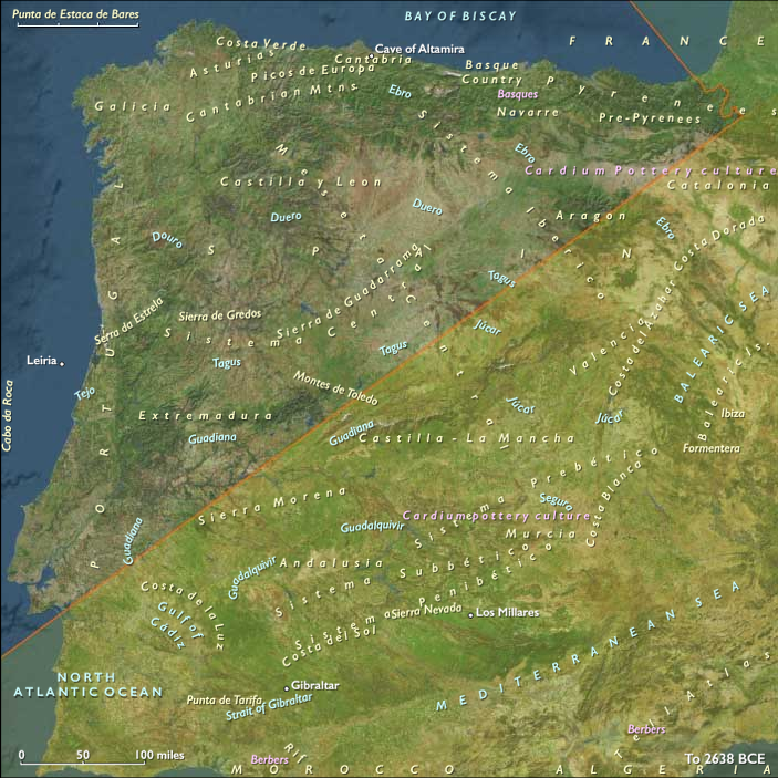
Atlantic Southwest Europe—the Cantabrian and Portuguese coasts (Galicia → Minho–Douro → Mondego–Tagus–Sado–Guadiana), the Bay of Biscay rias, and lowland deltas from Aquitaine to the Algarve—a rim of rias, dune-lagoon strings, and estuaries fed by oak–hazel uplands.
Postglacial rise slowed toward near-modern shorelines: estuaries stabilized, marshes spread, and forest belts thickened from Iberian sierras to Apennine foothills.
Climate & Environmental Shifts
The Holocene Thermal Maximum brought warm, wet, seasonally predictable conditions.
Mediterranean rains pulsed regularly; Atlantic storm tracks were gentle enough to let rias and marshes infill and mature. Oak–hazel forests reached wide extent while reedbeds, dune slacks, and upland grass mosaics persisted as rich ecotones.
Subsistence & Settlement
Semi-sedentary, water-anchored lifeways converged across both façades:
-
Mediterranean belt: Lagoon villages clustered along Languedoc–Camargue and the Valencian–Andalusian shelves; diets paired mullet/eel/fish-weir catches, waterfowl, turtles, and shellfish with hazelnuts, acorns, deer/boar from forest valleys. Apennine groups fished the Po floodplain; Sicily–Sardinia supported shellfish stations and pig/deer hunts. Balearics and Malta were largely unoccupied.
-
Atlantic belt (balanced addition): Ria and estuary hamlets spread along the Galician rías, Asturian/Cantabrian coves, Gironde–Adour mouths, and Tagus–Sado–Guadiana lagoons. Communities harvested intertidal shellfish, salmon/sea-trout, flatfish, and seasonally tunny, with inland circuits for red deer/boar and heavy hazelnut harvests. Dune-ridge sites and barrier-island camps became long-lived seasonal nodes.
Across the region, households returned to the same levees, dune bars, rock shelters, and coves, building semi-sedentary villages without abandoning upland–lowland rounds.
Technology & Material Culture
A shared coastal toolkit underwrote surplus:
Microlithic triangles/trapezes for composite arrows; ground-stone adzes for canoe/house carpentry; nets, stake-weirs, basket traps, and dugout canoes for lagoon and estuary transport. Early ground-stone mortars processed nuts/seeds; ornaments in shell, bone, amber and ochre use persisted. Polished adzes and first ceramics touched peripheral zones late, via Danubian/Aegean contacts, but most storage relied on smoking/drying and organic containers.
Movement & Interaction Corridors
Water was the infrastructure:
-
Rhône–Saône linked Mediterranean lagoons to the interior (and, downstream, ideas toward the Danube).
-
Ebro–Tiber–Po rivers funneled goods between coast and upland foragers.
-
Atlantic cabotage stitched Galicia ↔ Cantabria ↔ Aquitaine and the Portuguese shelf; Tagus–Sado–Guadiana corridors bound interior sierras to marsh villages.
These braided lanes created redundancy—if a tunny run thinned or a shell bank failed, another estuary supplied calories and salt.
Cultural & Symbolic Expressions
Coasts and rivers became ritual topographies:
-
Shell middens doubled as ancestral monuments; mortuary zones with ornaments and ochre formalized tenure at landing places and weirs.
-
Levantine-style rock art in eastern Iberia depicted hunters, deer, and social scenes; shrine stones and hearth complexes marked coves and lagoon margins.
-
Feasts at shellfish/tunny peaks renewed inter-village compacts and route rights across both façades.
Environmental Adaptation & Resilience
Households engineered stability via portfolio subsistence + storage + mobility:
Smoked/dried fish and meats, nut roasting, and fat rendering supported overwintering; multi-ecotone scheduling(lagoon/marsh/forest/upland) smoothed inter-annual variability; canoe mobility distributed pressure across fisheries, while ritual access rules constrained over-take.
Long-Term Significance
By 6,094 BCE, Southwest Europe was a paired-façade Mesolithic heartland: lagoon villages around the Mediterranean and ria–estuary communities along the Atlantic—both already knit to inland valleys by river corridors.
This mature, storage-capable forager world—semi-sedentary water economies, shell-midden ancestry, canoe logistics, and shrine-marked tenure—formed the substrate upon which Neolithic farming intrusions (from the Po–Tiber–Rhône and across the Ebro corridor) would soon graft without erasing the deep grammar of coast and river.
Commodities
Subjects
Regions