Gulf and Western North America (4,365–2,638 BCE)…
4365 BCE to 2638 BCE
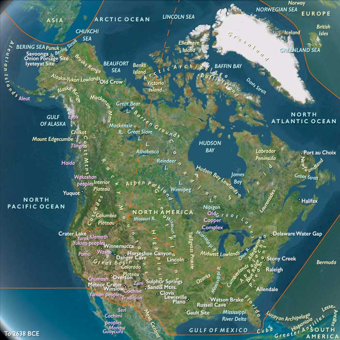
Gulf and Western North America (4,365–2,638 BCE)
Late Neolithic / Chalcolithic — Wetlands, Desert Corridors, and Coastal Fisheries
Geographic & Environmental Context
Gulf and Western North America stretched from the Lower Mississippi Valley and Gulf Coast westward across the Southern Plains, Southwest deserts, Colorado Plateau margins, Great Basin wetlands, California river systems, and the Channel Islands.
The region contained extraordinary environmental diversity. Vast marshes occupied the Lower Mississippi and Gulf estuaries. Grasslands spread across Texas, Oklahoma, and Kansas. The Rio Grande, Gila, Salt, and Pecos systems threaded through deserts and canyonlands. Great Basin playas alternated between seasonal abundance and aridity, while California's Sacramento–San Joaquin Delta formed one of North America's richest wetland complexes. Along the Pacific margin, productive coastal fisheries linked mainland California to the Channel Islands.
Although ecologically varied, these landscapes shared a common logic: rivers, wetlands, estuaries, and seasonal water sources concentrated life and structured movement across otherwise immense territories.
Climate & Environmental Shifts
The Late Holocene brought gradually cooler and somewhat drier conditions than the preceding thermal optimum. River systems stabilized near modern courses, marshes accumulated organic sediments, and coastal estuaries expanded.
Periodic droughts affected interior basins and desert margins, while seasonal flooding refreshed Gulf and California wetlands. Great Basin lakes continued their long postglacial retreat, leaving a mosaic of marshes, playas, springs, and seasonal water bodies that concentrated wildlife and human activity.
Subsistence & Settlement
Communities relied on highly diversified subsistence systems adapted to local ecologies.
Along the Gulf Coast and Lower Mississippi, fisheries, shellfish harvesting, waterfowl hunting, nut collecting, and riverine gathering supported increasingly permanent settlements. Shell middens accumulated near estuaries, marsh margins, and favored fishing grounds.
Across the Southern Plains and Southwest, hunting, seed gathering, and exploitation of river corridors remained fundamental. Seasonal camps clustered near springs, drainages, and floodplains where plant resources were most abundant.
In California and the Sacramento–San Joaquin Delta, fisheries, shellfish, waterfowl, acorns, and wetland resources supported dense occupation. The Channel Islands sustained maritime communities dependent upon fisheries, seabirds, shellfish, and inter-island canoe travel.
Throughout the region, settlement patterns balanced permanence with mobility, allowing communities to track seasonal abundance while maintaining enduring ties to favored places.
Technology & Material Culture
Groundstone technology expanded significantly during this epoch.
Millingstones, mortars, pestles, grinding slabs, basketry, cordage, fishing nets, fish traps, and dugout canoes became increasingly important. Fiber-tempered and regional ceramic traditions emerged in portions of the Gulf Coast and Lower Mississippi.
Shell ornaments, pigments, worked stone, and selected marine materials circulated through exchange networks linking wetlands, grasslands, deserts, and coastal zones.
Basketry traditions flourished throughout California, the Great Basin, and the Southwest, supporting storage economies that buffered seasonal uncertainty.
Movement & Interaction Corridors
Movement followed water.
The Lower Mississippi and its tributaries connected Gulf estuaries to interior woodlands. Coastal canoe routes linked bays, marshes, and shellfish grounds along the Gulf shoreline.
Farther west, the Rio Grande, Pecos, Gila, and Salt systems formed corridors across otherwise arid landscapes. Great Basin travel concentrated around springs, marshes, and seasonal lakes.
In California, the Sacramento–San Joaquin Delta functioned as a vast inland transportation network, while coastal routes connected estuaries, fisheries, and the Channel Islands.
These overlapping pathways created a broad exchange system linking aquatic, grassland, desert, and coastal environments.
Belief & Symbolism
Water occupied a central place in ritual life.
Shell middens, burial areas, fishing stations, springs, river confluences, and prominent wetland locations accumulated symbolic importance through repeated use across generations.
Seasonal gatherings reinforced alliances and exchange relationships, while ritual feasting accompanied periods of fish abundance, shellfish harvest, and waterfowl migrations.
Rock art traditions expanded across desert margins and canyon systems, linking sacred geography to seasonal movement routes.
Adaptation & Resilience
Communities responded to environmental variability through mobility, storage, and diversification.
Wetland resources buffered droughts. Seed processing and storage reduced seasonal uncertainty. Exchange networks redistributed food and materials between ecological zones. River systems, marshes, springs, and estuaries acted as refugia during periods of environmental stress.
The result was a highly resilient landscape of interconnected communities capable of exploiting a remarkable range of environments.
Long-Term Significance
By 2,638 BCE, Gulf and Western North America had developed durable traditions of wetland management, fisheries, seed economies, shell-midden occupation, canoe transport, and desert-waterway mobility.
The organizational principles established during this epoch—seasonal scheduling, storage, aquatic resource management, and regional exchange—would later support the emergence of the Lower Mississippi ceremonial traditions, California village societies, Southwest irrigation systems, and the complex cultural landscapes that characterized western North America in subsequent ages.
Images

Gulf and Western North America in the Late Holocene
Groups
Topics
Subjects
Regions
Northern North America
View →Subregions
