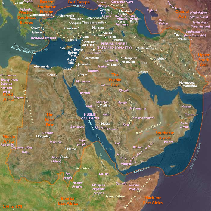
Armenia, after contact with centers of early…
244 CE to 387 CE
Armenia, after contact with centers of early Christianity at Antioch and Edessa, accepts Christianity as its state religion in 306 (the traditional date—the actual date may have been as late as 314), following miracles said to have been performed by Saint Gregory the Illuminator, son of a Parthian nobleman.
Thus Armenians claim that Tiridates III (238- 314) was the first ruler to officially Christianize his people, his conversion predating the conventional date (312) of Constantine the Great's legalization of Christianity on behalf of the Roman Empire.
Groups
Regions
The Near and Middle East
View →Subregions
Middle East
View →Related Events
No active filters.
Showing 10 events out of 60531 total
We begin in the easternmost subregions and move westwardly around the globe, crossing the equator as many as six times to explore ever shorter time periods as we continue to circle the planet. The maps of the regions and subregions change to reflect the appropriate time period.
Narrow results by searching for a word or selecting from one or more of a dozen filters.
Northeast Asia (244–675 CE): Okhotsk Mariners and Amur Frontiers
Northeast Asia includes eastern Siberia east of the Lena River to the Pacific, the Russian Far East (excluding the southern Primorsky/Vladivostok corner), northern Hokkaidō (above its southwestern peninsula), and extreme northeastern Heilongjiang.
Anchors
- Mohe expansions
- Amur frontier polities
- Sakhalin exchange nodes
- Okhotsk coastal settlements
- northern Hokkaidō communities
Climate & Environmental Conditions
Climatic variability encouraged diversification between inland, riverine, and coastal economies.
Subsistence & Settlement
Three interconnected economic zones emerged:
- river fisheries
- coastal marine hunting
- interior taiga hunting
Okhotsk communities increasingly specialized in marine resources.
Technology & Material Culture
Iron tools became commonplace.
Diagnostic technologies included:
- bone harpoons
- marine hunting equipment
- improved canoes
- larger storage systems
Movement & Interaction Corridors
Regular movement linked:
- Amur basin
- Sakhalin
- Hokkaidō
- Sea of Okhotsk coastlines
Cultural & Symbolic Expressions
Bear ceremonialism and marine-oriented ritual traditions became increasingly prominent.
Environmental Adaptation & Resilience
The combination of coastal, riverine, and inland economies created exceptional resilience.
Legacy & Transition
By 675 CE, the foundations of the Okhotsk cultural sphere and later northern Hokkaidō developments were clearly established.
Northwestern North America (244–675 CE): Grease Trails, Arctic Frontiers, and Coastal Polities
Geographical Parameters
(Same as above.)
Anchors
- Norton communities
- Birnirk precursors
- Fraser Canyon towns
- Haida Gwaii
- Central Coast chiefdoms
- Cook Inlet and Prince William Sound
Climate & Environmental Conditions
Environmental variability reinforced the value of storage systems, exchange networks, and route redundancy.
Subsistence & Settlement
Three major systems became increasingly interconnected:
- Arctic marine economies
- coastal ranked villages
- interior salmon towns
Settlement permanence expanded while seasonal mobility remained important.
Technology & Material Culture
- specialized marine hunting equipment
- increasingly large canoes
- storage infrastructure
- oil technologies
- advanced woodworking
Movement & Interaction Corridors
Grease trails and coastal canoe routes intensified interaction between ecological zones.
Cultural & Symbolic Expressions
Ceremonial exchange and lineage systems strengthened across the region.
Environmental Adaptation & Resilience
Multiple overlapping transportation systems maintained stability through environmental fluctuations.
Legacy & Transition
By 675 CE, the foundations of classic Northwest Coast societies and emerging Birnirk adaptations were firmly established.
North Polynesia (244–675 CE): Approaching the Northern Ocean
Geographical Parameters
North Polynesia includes the Hawaiian Islands chain except Hawaiʻi Island (the Big Island)—principally Oʻahu, Maui, Kauaʻi, Molokaʻi, Lānaʻi, Niʻihau—and Midway Atoll.
Anchors
- Oʻahu windward valleys
- Kauaʻi channels
- Maui Nui lee shores
- Midway Atoll
Climate & Environmental Conditions
Reliable trade winds and seasonal swells increasingly favored long-range exploration.
Ecological Baseline
The islands remained effectively unoccupied.
Yet Polynesian navigational systems elsewhere reached unprecedented sophistication.
West Polynesia (244–675 CE): Chiefdom Seeds and Ocean Networks
Geographical Parameters
West Polynesia includes Hawaiʻi Island (the Big Island); Tonga (Tongatapu, Haʻapai, Vavaʻu); Samoa (Savaiʻi, Upolu, Tutuila/Manuʻa); Tuvalu and Tokelau; the Cook Islands; the Society Islands; and the Marquesas.
Anchors
- Tongatapu ceremonial centers
- Samoa lineage landscapes
- Fiji–Tonga–Samoa exchange routes
Climate & Environmental Conditions
Trade-wind routes increasingly supported long-range movement and cultural integration.
Subsistence & Settlement
Chiefly authority became increasingly visible.
Settlements expanded around:
- reef systems
- taro valleys
- canoe landings
Movement & Interaction Corridors
Robust exchange linked:
- Tonga
- Samoa
- Fiji
while exploratory voyages increasingly pushed outward.
Okvik Culture (244–387 CE)
St. Lawrence Island’s Distinctive Style and the Dialogues of OBS
The Okvik culture, named for the northern Punuk Islands southeast of St. Lawrence Island, flourished in the mid-3rd to 4th centuries CE. Archaeologists see it as a contemporary counterpart to the developed Old Bering Sea traditionaround 300 CE — its communities inhabiting the same Bering Strait world, but expressing it with distinctive material and social emphases.
Okvik sites are especially renowned for their ivory carving style, marked by bold incisions, spirals, and figurative forms that set them apart from the more geometric OBS patterns. Harpoon heads, snow goggles, and ornaments recovered at Okvik display both artistry and practical refinement. Some depict stylized human or animal faces, perhaps embodying spiritual guardianship.
Subsistence paralleled that of OBS communities: marine hunting of walrus, seals, and whales, complemented by fishing and foraging. Okvik groups also engaged in long-distance exchange — their materials show ties to Siberia, Alaska, and neighboring island groups.
What distinguishes Okvik in the archaeological record is less subsistence and more identity of style. Many specialists treat Okvik as a regional expression of OBS, while others view it as a separate but allied tradition that coexisted and interacted with OBS communities. Either way, the Okvik horizon reveals a world of dialogue between island and mainland, where artistry was as much about signaling belonging and prestige as about decorating tools.
By the later 4th century, the Okvik tradition began to fade, merging into the broader Punuk trajectory that would reshape Bering Strait societies by the early medieval period.
Funan's population during this early period in its history is probably concentrated in villages along the Mekong River and along the Tonle Sab River below the Tonle Sap.
Traffic and communications are mostly waterborne on the rivers and their delta tributaries.
The area is a natural region for the development of an economy based on fishing and rice cultivation.
There is considerable evidence that the Funanese economy depends on rice surpluses produced by an extensive inland irrigation system.
Maritime trade also plays an extremely important role in the development of Funan.
The remains of what is believed to have been the kingdom's main port, Óc Eo (now part of Vietnam), contain Roman as well as Persian, Indian, and Greek artifacts.
A time of turbulence in China follows the demise of the Han dynasty, with six different dynasties in succession coming to power from the third to the sixth century.
The periods between dynasties or the periods when dynasties are weak in China are usually the most peaceful in Vietnam.
When dynasties are strong and interfere with local rule, the Vietnamese aristocracy engages in a series of violent revolts that weaken China's control over its southern territory.
A rebellion led by the noblewoman Trieu Au (Lady Trieu) in 248 is suppressed after about six months, but its leader earns a place in the hearts and history of the Vietnamese people.
Despite pressure to accept Chinese patriarchal values, Vietnamese women continue to play an important role and to enjoy considerably more freedom than their northern counterparts.
Maritime East Asia (244–387 CE): Fragmentation, Cultural Evolution, and Regional Realignments
Between 244 CE and 387 CE, Maritime East Asia—comprising lower Primorsky Krai, the Korean Peninsula, the Japanese Archipelago below northern Hokkaido, Taiwan, and southern, central, and northeastern China—experiences profound political fragmentation, regional realignments, cultural evolution, and technological innovation following the collapse of the Han dynasty.
Fragmentation and the Rise of Regional Powers
The collapse of the Han dynasty ushers in nearly four centuries of fragmentation, beginning with the era of the Three Kingdoms (Wei, Shu, and Wu, 220–280 CE). While later romanticized for chivalry, this era is marked by widespread warfare. The brief reunification under the early Jin dynasty (265–420 CE) proves fragile, unable to withstand persistent invasions by northern nomadic groups.
Forced to flee from Luoyang in 317 CE, the Jin court relocates to Nanjing, signaling China's division into successive dynasties and kingdoms lasting until 589 CE. This period sees accelerated sinicization, as non-Chinese groups integrate culturally, notably accompanied by the spread of Buddhism, introduced in the first century CE.
Technological and Cultural Advancements
Despite political fragmentation, significant technological advancements occur. Innovations such as gunpowder(initially for fireworks), the wheelbarrow, and notable developments in medicine, astronomy, and cartography emerge during this turbulent period.
Developments in Korea: Baekje, Goguryeo, and Silla
On the Korean Peninsula, three powerful states emerge: Baekje in the southwest, Goguryeo in the north, and Silla in the southeast.
Baekje, known for its centralized aristocratic structure, emerges strongly by 246 CE, aggressively expanding northward. Its King Kun Ch'ogo (r. ca. 346–375) establishes a lasting royal succession tradition, and in 384 CE, Buddhism is officially adopted as the state religion.
Goguryeo, initially developed near the Yalu River, expands significantly, conquering the Chinese-held region of Lelang in 313 CE. Situated in rugged terrain and harsh climates, Goguryeo becomes a major regional power, heavily influencing Korean history and identity, particularly as claimed by modern North Korea.
Silla, with its capital at Kyongju, becomes known for its cultural richness. The ruling elites from Silla’s region will notably dominate South Korean political leadership in later historical periods, shaping its national historical narrative.
The Kofun Period in Japan
In Japan, the Kofun period represents a critical evolutionary stage toward state formation. Society flourishes particularly along the eastern Inland Sea, with Japanese military influence extending onto the southern Korean Peninsula. Early Japanese rulers actively seek and obtain diplomatic recognition from China. Chinese records from this period describe the Japanese (Wa) society as fragmented, yet increasingly centralized under powerful leaders like the famed queen Himiko of Yamatai, who maintains diplomatic relations with China’s Wei Dynasty (220–265 CE).
Influence of Migration: Wu Hu Tribes
The period witnesses significant migrations into China by various non-Chinese tribes collectively termed the Wu Hu (Five Hu). Initially pastoral nomads from the steppe regions, these tribes leverage the collapse of central authority to settle extensively in the fertile North China Plain, reshaping the region’s demographic and cultural landscape.
Legacy of the Age: Political Realignment and Cultural Foundations
Thus, the age from 244 to 387 CE is characterized by political fragmentation, significant cultural evolution, and regional realignments. Despite instability, this era establishes enduring cultural and political foundations, significantly influencing the historical trajectories of China, Korea, and Japan.
Goguryeo, however, extends over a wild region of northwestern Korea and eastern Manchuria subjected to extremes of temperature and structured by towering mountain ranges, broad plains, and life-giving rivers.
The highest peak, known as Paektu-san (Mount Paektu, or White Head Mountain), is situated on the contemporary North Korea-China border and has a beautiful, crystal-pure lake at its summit.
Kim II Sung and his guerrilla band will utilize associations with this mountain as part of the founding myth of North Korea, just as Kim Jong II will be said to have been born on the slopes of the mountain in 1942.
Unsurprisingly, North Korea will claim the Goguryeo legacy as the mainstream of Korean history.