Southeast Arabia (1252 – 1395 CE): Rasulid…
1252 CE to 1395 CE
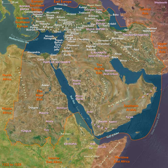
Southeast Arabia (1252 – 1395 CE): Rasulid Hadhramaut, Nabhani Dhofar, and the Socotran Sea-Lanes
Geographic and Environmental Context
Southeast Arabia includes the Empty Quarter of Saudi Arabia (Rubʿ al-Khālī fringes), eastern Yemen (Hadhramaut and the eastern Aden hinterland), the southern regions of Oman (Dhofar and al-Wusta), and the island of Socotra.
-
Anchors: the wadi systems of Hadhramaut (Shibam–Tarim), the monsoon-watered escarpments of Dhofar(Ẓafār/Al-Balīd, Mirbat), the al-Mahra coast and desert margins, and Socotra amid the Arabian Sea monsoon routes.
Climate and Environmental Shifts
-
The transition into the Little Ice Age (after c. 1300) brought greater interannual variability: Hadhramaut’s flash-flood (sayl) cycles alternated good date harvests with destructive torrents; Dhofar’s khareef (summer monsoon fog/rain) remained dependable but shifted in intensity year to year.
-
The Empty Quarter stayed hyper-arid; livelihoods clustered on its fringes (wells, oases, incense groves).
-
Socotra’s orographic mists sustained dragon’s-blood woodlands and aloe, while fisheries weathered monsoon seasonality.
Societies and Political Developments
-
Rasulid Yemen (1229–1454): the Rasulid sultans (based in Taʿizz/Zabīd) asserted overlordship across Hadhramaut, appointing amirs and taxing ports like al-Shihr; their coinage and road building integrated the east with highland markets and Aden (outside this subregion).
-
Hadhramaut interior: urban lineages in Shibam and Tarim consolidated oasis authority; the Bā ʿAlawī Sufi tradition (e.g., al-Faqīh al-Muqaddam, d. 1299) aligned jurists, merchants, and sayyid families who would seed a wider Indian Ocean diaspora.
-
Dhofar (southern Oman): under the Nabhani dynasty’s southern sphere, coastal Ẓafār/Al-Balīd and Mirbat remained regional entrepôts; hill tribes (Jebbali/Qara) managed frankincense groves.
-
Mahra Sultanate of Qishn and Socotra (from mid-13th c.): the Mahra established control over Socotra and the eastern Yemeni littoral, policing passages and taxing resin, turtle shell, and aromatics.
Economy and Trade
-
Agrarian–oasis cores: date-palm irrigation in Wādī Hadhramaut; sorghum and garden crops in flood-recession fields; livestock on Dhofar’s khareef pastures.
-
Incense & resins: frankincense (Boswellia sacra) from Dhofar; dragon’s-blood resin and aloe from Socotra; benzoin/camphor transshipped via Hadhramaut ports.
-
Maritime commerce: coastal al-Shihr and Dhofari harbors moved aromatics, horses, hides, and dates to Calicut (Kozhikode), Hormuz, Gujarat, and the Swahili Coast; return cargoes included pepper, cotton textiles, sugar, and ceramics.
-
Monetary flows: Rasulid tanka and dinars circulated alongside foreign silver; port taxes and maks on caravans funded garrisons and lighthouse/harbor upkeep.
Subsistence and Technology
-
Water management: masonry canals and sāqiya (water-wheel) systems lifted irrigation in Hadhramaut oases; stone terrace walls trapped sayl runoff; Dhofar used fog-drip cisterns and springs.
-
Caravan & craft: camel caravans linked incense groves to ports; Hadhrami mud-brick tower houses (notably at Shibam) maximized dense urban footprints; fine palm-matting, leather, and copperware supported trade.
-
Vessels: sewn-plank and pegged Arabian dhows (including badan, baghlah) rode the monsoon, with seasonal haul-outs along the Mahra–Dhofar coast.
Movement and Interaction Corridors
-
Incense roads: Dhofar uplands → Ẓafār/Mirbat; interior tracks from Wādī Ḥaḍramawt out to al-Shihr and west to Aden.
-
Sea-lanes: Socotra as a weather/supply stop on Gujarat/Calicut ⇄ Hormuz/Aden runs; seasonal tacks exploited the SW/NE monsoons.
-
Desert fringes: Mahra and Bedouin clans moved along the Rubʿ al-Khālī margins, linking wells, pastures, and caravan stations.
Belief and Symbolism
-
Islamic scholarship & Sufism: Hadhramaut’s Bā ʿAlawī scholars cultivated khanqāh circles and madrasas, sanctifying trade and kin networks; Rasulid patronage endowed mosques and waqf lands.
-
Tribal customary law: oath and diya frameworks arbitrated pasture, wells, and caravan protection in Dhofar–Mahra zones.
-
Syncretic coastal piety: sailor shrines and saints’ tombs dotted capes and islands; Qurʾanic recitation accompanied departure/return rituals.
Adaptation and Resilience
-
Monsoon pragmatism: merchants staggered sailings; ports kept dual basins for fair- and foul-season anchorage.
-
Diversified portfolios: oases (dates, grains), upland herding, frankincense groves, and fisheries spread climatic and market risk.
-
Institutional layering: Rasulid coinage and courts coexisted with Mahra tribal rule and Nabhani oversight—allowing commerce despite limited central reach.
-
Diasporic ties: Hadhrami families developed marriage–trade networks across Gujarat, Deccan, and Malabar, smoothing credit and insurance.
Long-Term Significance
By 1395, Southeast Arabia functioned as a maritime–oasis hinge of the western Indian Ocean:
-
Rasulid administration monetized Hadhramaut’s ports and caravan roads;
-
Nabhani Dhofar and the Mahra Sultanate secured incense groves and Socotra’s straits;
-
Hadhrami Bā ʿAlawī learning welded commerce to sanctity, laying foundations for a far-reaching diaspora in the centuries ahead;
-
Despite harsher variability under the early Little Ice Age, the region’s monsoon intelligence, diversified ecologies, and layered authority kept the incense coast central to Afro-Eurasian exchange.
Images

Southeast Arabia (with civilization) ©2024-24 Electric prism, Inc. All rights reserved
Groups
Commodities
Subjects
Regions
The Near and Middle East
View →Subregions
