Abbasid Caliphate (Baghdad)
State | Defunct
892 CE to 1258 CE
The Abbasid Caliphate is the third of the Islamic caliphates to succeed the Prophet Muhammad.
The Abbasid dynasty descends from the Prophet's youngest uncle, Abbas ibn Abd al-Muttalib (566–653 CE).
They rule as caliphs from their capital in Baghdad, in modern Iraq, after taking over authority of the Muslim empire from the Umayyads in 750 CE (132 AH).The Abbasid caliphate first centers its government in Kufa, but in 762 the caliph Al-Mansur founds the city of Baghdad, north of the Persian city of Ctesiphon.
The choice of a capital so close to Persia proper reflects a growing reliance on Persian bureaucrats, most notably of the Barmakid family, to govern the territories conquered by Arab Muslims, as well as an increasing inclusion of non-Arab Muslims in the ummah.
Despite this cooperation, the Abbasids of the 9th century are forced to cede authority over the Persian provinces to local dynastic emirs who only nominally acknowledge their suzerainty.
This marks the beginning of a wider breakdown of Abbasid authority, with the loss of Al-Andalus and Maghreb to the Umayyads, Ifriqiya to the Aghlabids, and Egypt to the Shi'ite Caliphate of the Fatimids.
The political power of the caliphs largely ends with the rise of the Buyids and the Seljuq Turks.Although Abbasid leadership over the vast Islamic empire is gradually reduced to a ceremonial religious function, the dynasty retains control over its Mesopotamian demesne.
The capital city of Baghdad becomes a center of science, culture, philosophy and invention during the Golden Age of Islam.
This period of cultural fruition ends in 1258 with the sack of Baghdad by the Mongols under Hulagu Khan.
The Abbasid caliphate, and Muslim culture in general, recenters itself in the Mamluk capital of Cairo in 1261.
The dynasty continues to claim authority in religious matters until after the Ottoman conquest of Egypt, when the position of caliph is formally surrendered to the Ottoman Sultan Selim I.
Capital
Worlds
The Great Crossroads
View →Related Events
Showing 10 events out of 650 total
Northern South Asia (820–1971 CE): Empires, Colonialism, and the Birth of Modern Nations
Medieval Empires and Dynastic Rule
From the early medieval period onward, Northern South Asia experiences significant dynastic changes. Islamic empires begin exerting influence from the 11th century with the Ghaznavids and later the Delhi Sultanate, reshaping cultural and political landscapes through trade, conquest, and cultural exchanges. Simultaneously, Afghanistan becomes a crucial frontier region, witnessing invasions and rule by various Turkic and Persian dynasties, including the Timurids and the early Mughals.
Nepal and Bhutan remain largely isolated, developing distinctive Himalayan cultures and systems of governance. In Nepal, the medieval period is characterized by the rule of various dynasties, such as the Mallas, who foster rich cultural and architectural traditions.
Mughal Ascendancy and Cultural Synthesis
The rise of the Mughal Empire in the 16th century under rulers like Babur, Akbar, and Aurangzeb marks a pinnacle of political and cultural achievement. The Mughals integrate diverse traditions, fostering a unique synthesis of Persian, Indian, and Central Asian cultures. Monumental architecture flourishes, exemplified by the Taj Mahal and the Red Fort. Administrative systems established under Akbar provide stability and governance across the empire, extending influence into modern-day Pakistan, Bangladesh, and parts of Afghanistan.
British Colonial Expansion
The weakening Mughal Empire in the 18th century facilitates the expansion of the British East India Company, climaxing with the pivotal Battle of Plassey in 1757. British dominance consolidates rapidly, leading to direct British rule following the Indian Rebellion of 1857–58. Afghanistan, however, remains fiercely independent, becoming a contested region between British India and Imperial Russia, sparking several Anglo-Afghan wars.
Meanwhile, Nepal under the Shah Dynasty and Bhutan under the leadership of the Wangchuck Dynasty maintain autonomy, though both engage diplomatically and militarily with British India. Bhutan eventually signs treaties with Britain, securing internal sovereignty while ceding some frontier territories.
Rise of Nationalist Movements
Nationalist movements emerge by the late 19th century, notably with the establishment of the Indian National Congress in 1885. Parallel to this, Sir Syed Ahmad Khan spearheads educational reforms for Muslims, founding the Muhammadan-Anglo Oriental College in 1875 (later Aligarh Muslim University), laying the foundation for Muslim political activism.
Afghanistan sees modernization and centralization efforts under leaders like Amir Abdur Rahman Khan (1880–1901), who solidifies borders and establishes the Durand Line with British India, a source of enduring tension.
Independence, Partition, and the Emergence of Modern States
Intense nationalist struggles, notably under Mahatma Gandhi and Muhammad Ali Jinnah, culminate in independence and the partition of British India in 1947, creating the independent dominions of India and Pakistan. The partition triggers massive migrations and communal violence, significantly reshaping the region.
Afghanistan navigates neutrality during this period, balancing relations between emerging global powers, while Nepal and Bhutan maintain independent monarchies, cautiously opening diplomatic relations with neighboring nations and beyond.
Post-Independence Challenges and Conflicts
The new states face immediate challenges, including economic stabilization, integration of princely states, and border disputes, notably over Kashmir. Pakistan experiences internal turmoil, leading to the separation of East Pakistan and the birth of Bangladesh in 1971, following a violent liberation struggle. India maintains democratic governance, embarking on industrialization and social reforms.
Afghanistan becomes a focal point of Cold War rivalry, undergoing rapid modernization, yet experiencing deep internal divisions, leading to instability that intensifies in subsequent decades.
Nepal and Bhutan cautiously engage in modernization while striving to preserve traditional identities. Bhutan introduces controlled development policies under the monarchy, and Nepal gradually opens to external influence.
Legacy of the Epoch
The epoch from 820 to 1971 profoundly shapes Northern South Asia, witnessing transitions from medieval empires to colonial subjugation, culminating in complex realities of independent nation-states. Legacies include cultural syncretism, unresolved regional tensions (particularly over Kashmir and the Durand Line), and socio-political structures inherited from colonial rule. These dynamics continue influencing contemporary geopolitics and societal developments across Northern South Asia.
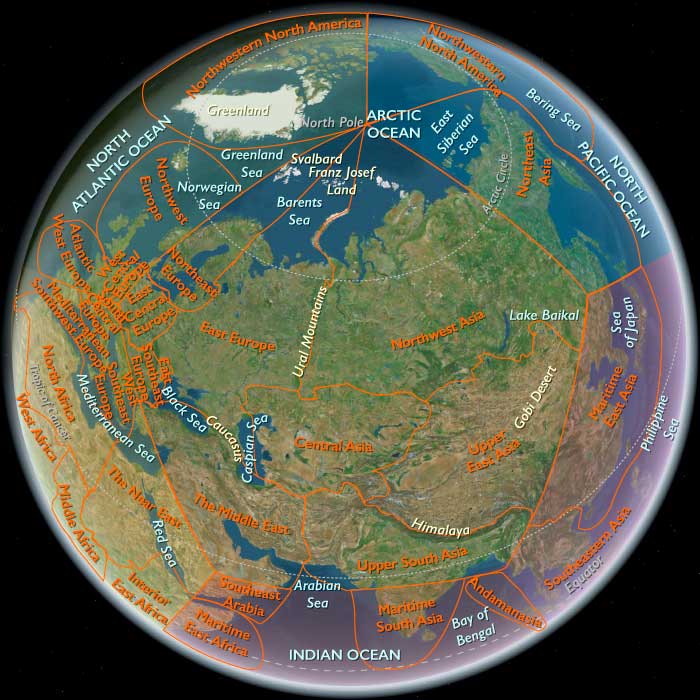
Central Asia (820 – 963 CE): Samanid Renaissance, Oasis Roads, and Steppe Frontiers
Geographic and Environmental Context
Central Asia includes the Syr Darya and Amu Darya basins (Transoxiana), Khwarazm and the Aral–Caspianlowlands, the Ferghana Valley, the Merv oasis and Kopet Dag piedmont, the Kazakh steppe to the Aral littoral, and the Tian Shan–Pamir margins.
-
A lattice of irrigated oases—Bukhara, Samarkand, Khwarazm/Urgench, Merv—was threaded by caravan tracks to Ferghana, Kashgar, and Nishapur.
-
Beyond the canals rose the steppe and semi-desert zones of Oghuz and Kipchak pastoralists, linking the Aral–Caspian to the Volga and Black Sea worlds.
Climate and Environmental Shifts
-
Warm–dry conditions with highly seasonal rivers (Syr/Amu); reliable irrigation made oases resilient while steppe pastures fluctuated with multi-year droughts.
-
Snowmelt-fed canals in the piedmont and river deltas underwrote bumper harvests; dune movement and salinization required continuous maintenance of canals and fields.
Societies and Political Developments
-
Tahirids (821–873) and Saffarids (861–1003) shaped the Khurasan–Sistan rim, but in Transoxiana the decisive power was the Samanid dynasty (819–999), ruling from Bukhara and Samarkand.
-
Under Nasr II (r. 914–943) and Nuh I (r. 943–954), Samanid authority stabilized Transoxiana and Khwarazm, balancing tributary ties with steppe tribes and asserting Sunni legitimacy against Ismaʿili activism.
-
Oghuz confederations along the Syr Darya gathered strength, controlling corridors toward the Caspian and brokering horses and slaves; Kimek–Kipchak groupings on the northern steppe grew more prominent.
-
In the far east, Karakhanid tribal blocs in Semirechye/Ferghana began coalescing (mid–late 10th c.), foreshadowing a new Turkic sovereignty over Transoxiana after 963.
Economy and Trade
-
Irrigated cereal and cotton agriculture flourished in the Zarafshan and Ferghana; orchards (apricot, grape, pomegranate) and silk weaving added value.
-
Samanid mints at Bukhara, Samarkand, and Nishapur struck vast quantities of silver dirhams; these coins fueled the Volga trade to Bulghar and the Rus’, turning Central Asia into a monetary engine of the wider Eurasian economy.
-
Caravan networks tied Merv–Nishapur to Rayy and the Iranian plateau, Bukhara–Samarkand to Kashgar and Khotan, and Khwarazm to the Caspian–Volga riverways.
-
Exports: textiles, sugar, paper, fruit syrups, refined silver; imports: slaves, furs, amber, swords from the north; horses, jade, tea, and silk from China; aromatics and pearls via the Persian Gulf.
Subsistence and Technology
-
Oases relied on canals and diversion weirs; in piedmont and delta zones, subterranean galleries (qanāt/kārīz) extended arable margins.
-
Paper-making (Samarkand tradition), book copying, and dyeing workshops thrived; iron foundries produced tools and blades for both oasis and steppe markets.
-
Steppe pastoralists fielded composite bows, lamellar armor, and remount herds; caravans and frontier garrisons purchased remount horses in quantity.
Movement and Interaction Corridors
-
The Transoxiana–Ferghana–Kashgar arc moved silk and jade west; the Khwarazm–Volga–Bulghar route moved dirhams and slaves north; the Merv–Nishapur–Rayy road linked to Baghdad and the Gulf.
-
Seasonal steppe corridors along the Syr and lower Amu carried Oghuz/Kipchak herds and raiding parties toward oasis frontiers—regulated by tribute, markets, and punitive expeditions.
Belief and Symbolism
-
Sunni Hanafi Islam anchored Samanid legitimacy; madrasas, mosques, and waqf endowments expanded in the oases.
-
A Persianate renaissance flourished at Bukhara: Rudakī and court poets inaugurated New Persian literature in Arabic script; Arabic scholarship (theology, medicine, astronomy) circulated through libraries and paper markets.
-
Ismaʿili missionaries operated in Khurasan–Transoxiana, but the Samanids suppressed them, positioning themselves as defenders of Sunnism.
-
Among Turkic steppe peoples, Tengri sky worship, ancestor cults, and shamanic practices persisted alongside growing contact with Islam.
Adaptation and Resilience
-
Oasis–steppe symbiosis—grain, textiles, and coin for horses, guards, and furs—reduced conflict costs and stabilized borders.
-
Canal upkeep and salt management preserved arable land; caravanserai provisioning reduced risk on long hauls.
-
Monetization via dirhams cushioned shocks by integrating Central Asia into Volga–Rus’–Baltic and Persian Gulf–Indian Ocean circuits.
-
Frontier diplomacy (tribute, hostage exchange, intermarriage) with Oghuz and Kipchak leaders channeled steppe pressures into trade.
Long-Term Significance
By 963 CE, Central Asia had entered a Samanid-led golden age:
-
A Persianate cultural core (Bukhara–Samarkand–Merv) powered scholarship and literature,
-
Irrigated oases turned river water into silk, sugar, and coin,
-
Steppe gateways delivered horses and transcontinental partners, and
-
The Karakhanids were poised on the Ferghana frontier, preparing to enter Transoxiana and inaugurate the next political cycle.
This age set the template for the region’s classic medieval pattern: Sunni–Persian urban courts, Turkic steppe military power, and caravan capitalism binding China, the Islamic world, and the North.
Bukhara becomes one of the leading centers of learning, culture, and art in the Muslim world, its magnificence rivaling contemporaneous cultural centers such as Baghdad, Cairo, and Cordoba.
Some of the greatest historians, scientists, and geographers in the history of Islamic culture are natives of the region.
As the Abbasid Caliphate begins to weaken and local Islamic Iranian states emerge as the rulers of Iran and Central Asia, the Persian language begins to regain its preeminent role in the region as the language of literature and government.
The rulers of the eastern section of Iran and of Mawarannahr are Persians.
The rich culture of Mawarannahr continues to flourish during the height of the Abbasid Caliphate in the eighth and the ninth centuries.
According to Chinese records, they grow Himalayan rye, barley, millet, and wheat.
They are also skilled iron workers, jewelry makers, potters, and weavers.
Their homes are traditional nomadic tents and, in the agricultural areas, wood and bark huts.
Their farming settlements are protected by log palisades.
The resources of their forested homeland (mainly fur) allow the Yenisei Kyrgyz to become prosperous merchants as well.
They maintain trading ties with China, Tibet, the Abbasid Caliphate of the Middle East, and many local tribes.
Kirghiz horses are also renowned for their large size and speed.
The tenth-century Persian text Hudud al-'alam describes the Kyrgyz as people who "venerate the Fire and burn the dead", and that they are nomads who hunt.
The political importance of Arabia in the Islamic world had declined by the latter part of the seventh century.
The Umayyads had been overthrown in 750 by the Abbasids, who rule from Baghdad.
Until about 900, the centers of Islamic power remain in the Fertile Crescent, a semicircle of fertile land stretching from the southeastern Mediterranean coast around the Syrian Desert north of the Arabian Peninsula to the Persian Gulf and close to the Arabian heartland.
After the ninth century, however, the most significant political centers move farther and farther away—to Egypt and India, as well as to what is now Turkey and the Central Asian republics.
Intellectual vitality eventually follows political power, and, as a result, Islamic civilization is no longer centered in Mecca and Medina in the Hijaz.
South Asia (820 – 963 CE): Pala Enlightenment, Pratihara Power, and Chola Renaissance
Geographic and Environmental Context
South Asia in this age stretched from the Afghan highlands and Himalayan passes to the southern seas of Sri Lanka and the Maldives, forming a vast subcontinental arc of riverine plains, mountain valleys, and monsoon-fed coasts.
It comprised two complementary worlds:
-
Northern South Asia, anchored in the Indo-Gangetic plains, Kashmir, and the Himalayan foothills, with frontier corridors through Afghanistan and Arakan.
-
Maritime South Asia, embracing the Deccan, Tamilakam, Sri Lanka, and the Indian Ocean islands, oriented toward sea routes and monsoon trade.
Across both, the monsoon system remained the ecological engine—its alternating rains feeding rice, millet, and spice economies that sustained great courts and temple complexes alike.
Climate and Environmental Shifts
The early Medieval Warm Period (c. 800–1200) stabilized monsoons and ensured abundant harvests.
-
Indo-Gangetic plains: reliable rainfall enabled intensive cultivation and urban renewal.
-
Bengal delta: expanded rice agriculture and monastic endowments.
-
Deccan and Tamilakam: seasonal but steady rains; irrigation networks multiplied.
-
Sri Lanka: the great tanks of Anuradhapura reached their hydraulic zenith.
-
Himalayas and frontier zones: salt–grain caravans balanced mountain scarcity and plain abundance.
Overall, this was a time of agrarian prosperity and maritime dynamism.
Societies and Political Developments
Northern South Asia: Pratihara Strength and Pala Enlightenment
-
Gurjara–Pratiharas (North India): From their capital at Kannauj, they dominated the Ganga–Yamuna heartland, checking both Pala expansion from the east and Rashtrakuta incursions from the south. Their reign marked the apex of early Rajput temple-building and Sanskrit culture.
-
Palas (Bengal–Bihar): Under Dharmapala and Devapala, the Pala Empire reached its zenith, extending from Bengal into Assam and Nepal, and patronizing Nalanda and Vikramaśīla, which drew monks from Tibet, China, and Southeast Asia.
-
Afghanistan & Frontier Regions: The Hindu Shahis of Kabul and Gandhara resisted Samanid pressures from the northwest, maintaining the last bastion of pre-Islamic rule in the region.
-
Himalayan Realms:
-
Nepal: The Licchavi dynasty waned as early Malla lineages rose, consolidating the Kathmandu Valley.
-
Bhutan: Fragmented highland polities absorbed Tibetan Buddhist influence via cross-Himalayan exchange.
-
-
Arakan and Chindwin Valleys: The Waithali dynasty in Arakan remained Theravāda Buddhist, maintaining trade and religious ties with Bengal and Pagan’s formative centers.
Maritime South Asia: Rashtrakuta Hegemony and Chola Ascent
-
Deccan and Tamilakam:
-
The Rashtrakutas dominated upland Deccan politics from Manyakheta, pressing north and south through cavalry raids.
-
In Tamilakam, the Pallavas of Kanchipuram declined while the Cholas, under early rulers like Vijayalaya (r. 848–871), reestablished control of the Kaveri delta, reviving temple construction and local administration.
-
Cheras in Kerala managed spice forests and timber exports; Pandyas retained influence around Madurai.
-
-
Sri Lanka:
-
The Anuradhapura kingdom reached an apex of irrigation and Buddhist scholarship under Sena I (r. 833–853) and successors.
-
Massive reservoirs and stupas sustained a thriving monastic culture; the island was a hub for Indian Ocean pilgrimage and trade.
-
-
Island Polities:
-
Maldives remained Buddhist, supplying cowries used as currency across Asia.
-
Lakshadweep and Chagos were sparsely inhabited fishing–coconut ecologies.
-
Economy and Trade
-
Agriculture:
-
Wheat and barley dominated Punjab; rice flourished in Bengal, Nepal, and the Tamil plains; millet and pulses anchored Deccan drylands.
-
Advanced irrigation: Doab canals, Bengal embankments, Kaveri–Vaigai tanks, and Anuradhapura reservoirs.
-
-
Artisanal production:
-
Pala bronzes and manuscripts; Kashmiri textiles and Buddhist iconography; Tamil stone temples and bronze icons (precursors of Chola art).
-
-
Trade networks:
-
Overland: Kabul–Punjab horse and silk routes; Himalayan salt–grain trade.
-
Maritime: Bengal textiles and sugar; Kerala’s pepper and cardamom; Sri Lankan pearls and elephants.
-
Ports: Tamralipta, Nagapattinam, Muziris, and Anuradhapura connected with Arab, Persian, and Southeast Asian merchants.
-
Maldives cowries and Sri Lankan gems circulated from Africa to China.
These arteries made South Asia a global trade hinge linking Islamic West Asia, Southeast Asia, and China.
-
Subsistence and Technology
-
Irrigation and Engineering: The Anuradhapura tanks and Kaveri delta weirs exemplified hydraulic mastery; smaller canal systems irrigated the Gangetic plains.
-
Architecture and Art:
-
Pala–Sena brick monasteries, Pratihara–Rajput stone temples, Chola Dravidian shrines, and Sri Lankan stupas.
-
-
Military Systems: Elephants and cavalry dominated plains warfare; fortifications protected upland citadels.
-
Maritime Technology: Multi-masted ships, stitched hulls, and monsoon navigation enabled seasonal crossings between India, Arabia, and Southeast Asia.
Movement and Interaction Corridors
-
Northern corridors: From Kabul–Kandahar into the Punjab and Gangetic plains, extending east to Bengal and Arakan.
-
Southern sea-lanes: From Coromandel and Malabar ports through Sri Lanka to Srivijaya and China’s south coast.
-
Himalayan routes: Carried Buddhist scriptures and artisans between Nalanda, Nepal, Tibet, and Bhutan.
-
Interlinkages: The Chindwin–Irrawaddy corridor connected Bengal to Southeast Asia, while Arab traders reached Gujarat and Ceylon by the monsoon pattern known as the mawsim.
Belief and Symbolism
-
Buddhism: Reached its intellectual zenith under Pala patronage; Nalanda was the beacon of Mahayana–Vajrayana philosophy spreading to Tibet and Southeast Asia.
-
Hinduism: The Pratiharas and Cholas upheld Shaiva and Vaishnava temple networks; local deities integrated into classical forms.
-
Syncretism: In Nepal, Hindu–Buddhist synthesis produced unique pagoda temples; Sri Lanka maintained Theravāda orthodoxy within a pan-Asian pilgrimage sphere.
-
Frontier faiths: Arakan and the Hindu Shahis blended Indic and regional elements; mountain and coastal peoples combined animism with Buddhist and Hindu motifs.
Adaptation and Resilience
-
Hydraulic management mitigated monsoon irregularity.
-
Regional diversity of crops ensured food security.
-
Temple endowments functioned as banks, granaries, and social safety nets.
-
Trade diversification—land, sea, and highland—protected economies from disruption.
-
Cultural pluralism fostered political resilience: Hindu, Buddhist, and local systems coexisted within flexible frameworks of kingship and monastic order.
Long-Term Significance
By 963 CE, South Asia stood as a continental mosaic of empires and maritime hubs:
-
In the north, the Pratiharas held Kannauj, the Palas radiated Buddhist culture, and Rashtrakutas bridged the Deccan.
-
In the south, the Cholas rose amid temple and irrigation revival, the Rashtrakutas ruled the uplands, and Anuradhapura flourished in Ceylon.
-
Across islands and seas, Maldivian and Sri Lankan trade extended India’s reach deep into the Indian Ocean world.
This age set the stage for the Chola maritime empire, the Pala Buddhist renaissance, and the Islamic incursions that would transform the subcontinent’s political and religious horizons in the centuries to come.
Upper South Asia (820 – 963 CE): Gurjara–Pratiharas, Pala Zenith, and Himalayan Gateways
Geographic and Environmental Context
Upper South Asia includes Afghanistan, Pakistan, North India, Nepal, Bhutan, Bangladesh, and northwestern Myanmar (northern Arakan/Yakhine and the Chindwin valley).
-
Anchors: the Indo-Gangetic plain from Punjab to Bengal, the Kathmandu Valley, the Himalayan foothills of Nepal and Bhutan, Kashmir, and the Arakan/Chindwin corridors tying Bengal to Upper Burma.
Climate and Environmental Shifts
-
The Medieval Warm Period brought generally favorable monsoons and stable agriculture across the plains.
-
Bengal’s delta supported intense rice farming; the Himalayas maintained balanced salt–grain trade flows.
-
Floods and cyclones periodically struck Bengal’s coastal zones.
Societies and Political Developments
-
North India (Gurjara–Pratiharas):
-
At their peak in the 9th–10th centuries, they controlled much of the Ganga–Yamuna heartland from Kannauj, contending with Palas and Rashtrakutas.
-
-
Bengal & Bihar (Palas):
-
The Pala Empire (Dharmapala, Devapala) flourished, patronizing Nalanda and Vikramaśīla monasteries; extended into Bihar, Assam, and parts of Nepal.
-
-
Afghanistan & Frontier:
-
Samanid influence pressed into Kabul; Hindu Shahis of Kabul and Gandhara held out against Muslim expansion until the 10th century.
-
-
Nepal: Licchavi dynasty waned; early Mallas rose by the late 9th century, consolidating Kathmandu’s valley polities.
-
Bhutan: fragmented valley principalities with growing Buddhist influence from Tibet.
-
Northwestern Myanmar:
-
Arakan (Waithali dynasty) remained Buddhist, linked to Bengal.
-
The Chindwin valley integrated into Pagan’s formative networks.
-
Economy and Trade
-
Agriculture: wheat/barley in Punjab; rice in Bengal and Nepal; millet/barley in Himalayan valleys.
-
Crafts: Pala Bengal known for bronze statuary and manuscripts; Kashmir produced high-quality shawls and Buddhist texts.
-
Trade:
-
Overland: Kabul–Punjab horse trade; Bengal–Assam–Arakan ports exchanged rice, elephants, and forest products.
-
Maritime: Bengal ports sent textiles, sugar, and rice to Southeast Asia.
-
Himalayan: salt and wool from Tibet exchanged for Nepalese and Gangetic grain.
-
Subsistence and Technology
-
Irrigation: early canals in the Doab; Bengal embankments; Kathmandu valley ponds and conduits.
-
Architecture: Pala brick monasteries; Pratihara temples in stone; Nepalese pagoda styles.
-
Military: cavalry and elephant corps in plains; fortresses in Kashmir and Kabul.
Movement and Interaction Corridors
-
Grand Trunk precursors: Punjab ⇄ Kannauj ⇄ Bengal.
-
Kabul–Kandahar passes: connected Central Asian Islamicate world to Hindu Shahis.
-
Himalayan passes: salt–grain flows between Tibet and Nepal/Bhutan.
-
Arakan/Chindwin: rice and elephants to Pagan’s early state.
Belief and Symbolism
-
Buddhism: Pala patronage of Mahayana/Vajrayana Buddhism; Nalanda as a global hub.
-
Hinduism: Gurjara–Pratihara and regional Rajput chiefs sponsored temples to Vishnu and Shiva.
-
Nepal: Hindu–Buddhist syncretism blossomed.
-
Arakan: Theravāda Buddhist traditions anchored kingdoms.
Long-Term Significance
By 963, Upper South Asia was a tripartite contest: Pratiharas in the west, Palas in the east, Rashtrakutas pushing north.
-
Bengal’s Pala culture radiated Buddhism across Asia.
-
Himalayan valleys matured into distinct polities.
-
Kabul–Gandhara remained a frontier resisting Islamization.
-
Bengal–Arakan–Chindwin tied the subregion firmly into Southeast Asia.
Southeast Arabia (820 – 963 CE): Frankincense Valleys, Desert Caravans, and Socotran Sailors
Geographic and Environmental Context
Southeast Arabia includes the Empty Quarter of Saudi Arabia, eastern Yemen (Hadhramaut and eastern Aden), the southern regions of Oman (Dhofar and al-Wusta), and the island of Socotra.
-
The Hadhramaut wadis supported clustered farming and trade towns.
-
Dhofar’s limestone escarpments sustained frankincense groves.
-
The Empty Quarter formed a sparsely populated desert barrier.
-
Socotra, in the Arabian Sea, served as a maritime waystation between Arabia and India.
Climate and Environmental Shifts
-
Hot, arid conditions dominated the interior;
-
The Khareef (monsoon rains) in Dhofar sustained frankincense trees;
-
Socotra’s semi-arid climate enabled mixed subsistence and resin gathering.
Societies and Political Developments
-
Hadhramaut towns (Shibam, Tarim predecessors) organized around tribal confederations.
-
Dhofar’s incense producers operated within tribal frameworks, exporting resin northward.
-
Socotra was under fluctuating Arab/Abbasid maritime influence, with local chiefs mediating between sailors and inland clans.
-
The Empty Quarter remained a nomadic domain, with Bedouin groups traversing fringes for pasture and caravan guidance.
Economy and Trade
-
Frankincense and myrrh from Dhofar and Hadhramaut remained the region’s most valuable exports, sold into Oman, Yemen, and northern markets.
-
Caravans carried aromatics through the desert to Najran (Near East) and beyond.
-
Socotra provided stopovers for Indian Ocean traders, supplying resins, honey, and dried fish.
Subsistence and Technology
-
Terrace farming and well irrigation in Hadhramaut wadis.
-
Resin tapping, goat herding, date palm cultivation.
-
Socotra’s outrigger canoes and sewn-plank boats enabled coastal and Indian Ocean crossings.
Movement and Interaction Corridors
-
Caravan trails linked Hadhramaut and Dhofar to Najran and Aden (Near East).
-
Maritime lanes through Socotra carried ships between Basra, Siraf, and western India.
Belief and Symbolism
-
Islam predominated under Abbasid influence, though tribal and customary rituals persisted in incense groves.
-
Socotra’s Christian community (a legacy of earlier Byzantine–Aksumite contact) coexisted with Muslims, gradually assimilating.
Long-Term Significance
By 963 CE, Southeast Arabia was a specialized incense-producing and maritime subregion, linking caravan deserts and Indian Ocean trade through Dhofar’s groves and Socotra’s harbors.
East Africa (820 – 963 CE): Swahili Beginnings, Highland Christianity, and the Great Lakes Mosaic
Geographic and Environmental Context
East Africa extended from the Somali coast to the Zambezi plateau, encompassing the Swahili littoral, the Comoros and Madagascar, and the highlands and lakes of the interior.
-
Maritime East Africa stretched from southern Somalia through Kenya, Tanzania, Mozambique, and the offshore islands—Lamu, Pate, Mombasa, Zanzibar, Pemba, Mafia, Kilwa Kisiwani, Songo Mnara, and the Comoros, as well as Madagascar, Seychelles, and the Mascarenes.
-
Interior East Africa reached from Eritrea and Ethiopia through Uganda, Rwanda, Burundi, South Sudan, and the Zambezi–Zimbabwe–Malawi basins.
Across this region, monsoonal winds, rifted uplands, and wetland corridors linked oceanic trade with inland agrarian and pastoral networks.
Climate and Environmental Shifts
The onset of the Medieval Warm Period brought relatively stable monsoons and favorable rainfall:
-
Coastal lowlands and river valleys sustained rice, banana, and millet cultivation.
-
Ethiopian Highlands maintained terrace farming under mild conditions.
-
Great Lakes basins offered abundant fish, fertile volcanic soils, and year-round agriculture.
-
Madagascar’s central plateau experienced reliable rainfall, supporting mixed rice and cattle economies.
-
Seychelles and Mascarene Islands remained uninhabited, their ecosystems dominated by seabirds, turtles, and endemic flora.
Monsoon stability ensured dependable sailing seasons, tying the region to the wider Indian Ocean world.
Societies and Political Developments
Maritime East Africa: Swahili Settlements and Island Frontiers
-
Along the Swahili coast, early towns such as Shanga, Lamu, and Mombasa emerged from Bantu-speaking coastal populations interacting with Arab and Persian traders.
-
These settlements evolved into cosmopolitan ports, blending African and Islamic influences and forming the nucleus of the Swahili culture.
-
The Comoros Islands hosted mixed Austronesian–African communities dependent on coconuts, fishing, and small-scale trade.
-
Madagascar was settled by Austronesian voyagers from Island Southeast Asia, who intermarried with African migrants; by the 9th century, highland villages and coastal chiefdoms were established.
-
Seychelles and Mascarene Islands were still uninhabited but served as occasional maritime waypoints for regional navigators.
Interior East Africa: Highland Faith and Great Lakes Foundations
-
In Ethiopia, the Aksumite kingdom had waned, yet Christianity endured in highland principalities sustained by monasteries and churches.
-
Around the Great Lakes, early Urewe pottery cultures transitioned into village-based farming and fishing societies—forerunners of later kingdoms such a Buganda and Bunyoro.
-
Nilotic herders (ancestors of Dinka, Nuer, and Shilluk) prospered along the Upper Nile, balancing cattle herding with seasonal farming.
-
Across the Zambezi corridor, northern Zimbabwe and Zambia saw the growth of millet and cattle-raising communities, prefiguring the complex societies of Great Zimbabwe.
Economy and Trade
-
Maritime exchange:
-
Exports included ivory, tortoise shell, rhinoceros horn, slaves, and forest goods, sent north to Arabia, Persia, and India.
-
Imports comprised glass beads, cloth, metal tools, and ceramics.
-
Madagascar supplied rice, cattle, timber, and aromatic resins, integrated into Swahili coastal trade.
-
-
Inland economies:
-
Agriculture: sorghum, millet, teff, and bananas; ensete (false banana) in Ethiopia; rice in Madagascar.
-
Pastoralism: cattle wealth structured exchange and ritual from South Sudan to Zimbabwe.
-
Trade corridors: ivory and hides moved from interior markets toward the Red Sea and Indian Ocean ports; salt, iron, and copper circulated within the plateau economies.
-
-
The Zambezi–Maputo–Kilwa routes became early arteries of trans-regional commerce, linking interior resources to the Indian Ocean world.
Subsistence and Technology
-
Agriculture and herding: floodplain and terrace farming in the highlands; dryland millet and sorghum in the south; banana and rice cultivation along the coast.
-
Fishing: Great Lakes, Rift Valley, and coastal estuaries supplied year-round food security.
-
Iron smelting: widespread from Ethiopia to Zimbabwe, producing hoes, spearheads, and trade implements.
-
Architecture: wattle-and-daub villages on the mainland; coral and mangrove timber in early Swahili towns; stone foundations appearing in the Zimbabwe plateau uplands.
-
Navigation: sewn-plank dhows and outrigger canoes moved between the coast, islands, and across to Madagascar.
-
Crafts: pottery, woven mats, bead jewelry, and metal tools underpinned both household and trade economies.
Belief and Symbolism
-
Christianity persisted in the Ethiopian Highlands, sustaining monasteries, cross traditions, and local saints’ cults.
-
Indigenous Bantu religions emphasized ancestor veneration, fertility, and rainmaking; cattle and lineage shrines symbolized continuity and wealth.
-
Sanctified nature: sacred groves, hills, and water sources marked boundaries between human and divine realms.
-
Austronesian influences in Madagascar and the Comoros reinforced ancestor worship and spirit mediation through household altars.
-
Along the Swahili coast, Islamic ideas blended with African spirituality, creating a hybrid cosmology that shaped early mosques and burial traditions.
Adaptation and Resilience
-
Environmental adaptation: diverse ecologies—coastal, highland, and wetland—enabled communities to shift between agriculture, herding, and fishing according to climate and resource cycles.
-
Monsoon navigation: predictable wind systems allowed coastal cities to synchronize markets with Arabia and India.
-
Agrarian resilience: intercropping and cattle herding buffered droughts; bananas and ensete ensured perennial food sources.
-
Social integration: kinship and exchange networks linked the highlands and coast through caravan and river routes.
-
Cultural synthesis: African, Austronesian, and Islamic elements blended to create flexible, adaptive societies on both sides of the Indian Ocean.
Long-Term Significance
By 963 CE, East Africa had become a continent-spanning corridor of trade, faith, and ecological diversity:
-
Swahili settlements from Shanga to Kilwa were firmly integrated into the Indian Ocean commercial sphere.
-
Madagascar and the Comoros embodied early Austronesian–African synthesis, while the Seychelles and Mascarenes remained ecological frontiers.
-
Ethiopia preserved Christian continuity amid the Islamic expansion around the Red Sea.
-
The Great Lakes and Zambezi–Zimbabwe region nurtured enduring agricultural and pastoral cultures that would evolve into state systems.
The age’s enduring legacy was a maritime–inland continuum: from coral-built ports and dhows riding the monsoon to inland cattle rituals and hilltop monasteries. It laid the foundations for the Swahili urban boom, Zagwe Christian revival, and Zimbabwean monumental architecture that would define East Africa in the centuries to come.
Maritime East Africa (820 – 963 CE): Early Swahili Settlements, Madagascar’s Highlands, and Island Outposts
Geographic and Environmental Context
Maritime East Africa includes the littoral and nearshore islands from southern Somalia through Kenya and Tanzania to northern and central Mozambique and southern Malawi, together with the offshore archipelagos of Lamu, Pate, Mombasa, Zanzibar, Pemba, Mafia, Kilwa Kisiwani, Songo Mnara, and the Comoros, as well as Madagascar, the Seychelles, and the Mascarene Islands.
-
Anchors: Mombasa, Dar es Salaam, Beira, Blantyre on the coast and uplands; Madagascar’s central highlands and western ports; small-island chains along the western Indian Ocean.
Climate and Environmental Shifts
-
The Medieval Warm Period brought relatively stable monsoon winds, ensuring reliable sailing seasons.
-
Rainfall supported rice and banana cultivation in coastal lowlands and Madagascar’s river valleys.
-
The Seychelles and Mascarene Islands were uninhabited, their ecosystems dominated by seabirds, turtles, and unique flora.
Societies and Political Developments
-
Swahili coast: settlements at Shanga, Lamu, and Mombasa grew from Bantu–Persian interactions.
-
Madagascar: settled by Austronesian migrants from Island Southeast Asia, blending with African communities; highland villages and coastal chiefdoms developed.
-
Comoros: mixed Austronesian–African societies flourished on fishing, coconuts, and small-scale trade.
-
Seychelles & Mascarene Islands: uninhabited, though visited by passing mariners.
Economy and Trade
-
Exports: ivory, tortoise shell, rhinoceros horn, slaves, and forest goods.
-
Imports: beads, cloth, and ceramics from Arabia, Persia, and India.
-
Madagascar supplied rice, cattle, and forest products into coastal exchange.
Belief and Symbolism
-
Indigenous Bantu religions on the coast blended with early Islam, arriving via Arab merchants.
-
Austronesian ancestor worship shaped Madagascar and Comoros rituals.
Long-Term Significance
By 963, the Swahili coast was knit into Indian Ocean exchange, while Madagascar, Comoros, and nearby archipelagos formed an interconnected cultural and economic frontier.