Event
Temperate Southern Africa (1828–1971 CE): Territorial Conquest,…
Temperate Southern Africa (1828–1971 CE): Territorial Conquest, Mineral-Industrial Corridors, and Racial States
Geographic Parameters
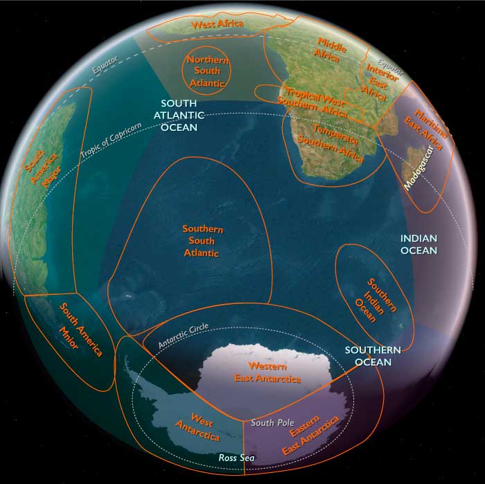
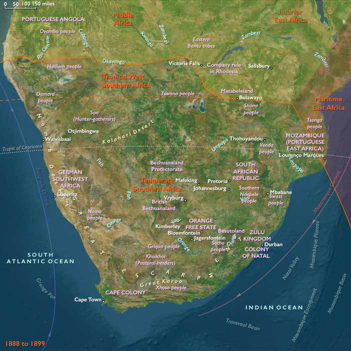
Temperate Southern Africa encompassed present-day South Africa, Lesotho, and Eswatini; most of Namibia and Botswana outside their far-northern tropical districts; southern Zimbabwe; and the Maputo–Limpopo corridor of southwestern Mozambique. Its principal environmental anchors remained the Cape littoral and Fold Mountains, Namaqualand, the Orange River, the Karoo basins, the southern Kalahari margins, Makgadikgadi, the Highveld and Bushveld plateaus, the Drakensberg and Lesotho uplands, the Eswatini hills, the Limpopo basin, the southern Zimbabwe plateau, and Maputo Bay.
The age did not produce a uniformly industrial or colonized landscape. Mining and metropolitan growth became concentrated around Kimberley, the Witwatersrand, selected railway corridors, ports, and company towns. Commercial farms occupied favorable valleys and grasslands, while African household agriculture, cattle keeping, mission settlements, customary land systems, labor migration, and mobile use of dryland environments continued across most of the subregion.
By 1971, the territory had been divided among apartheid South Africa, independent Botswana, Lesotho, and Swaziland, South African-occupied Namibia, white-minority-ruled Rhodesia, and Portuguese Mozambique. These borders fragmented older ecological, kinship, political, and labor networks without preventing movement across them.
Environmental Continuity
Rainfall variability, pasture, fire, frost, soil fertility, and access to water continued to determine where people could farm, herd, mine, and settle. The Cape’s winter-rainfall districts supported wheat, fruit, vines, sheep, and mixed farming; the Karoo and Namaqualand favored extensive pastoralism; the Highveld supported summer grains, cattle, commercial maize, and later the principal mining-industrial corridor. Lesotho’s mountains supplied water, grazing, cultivation, and defensive terrain, while southwestern Mozambique’s riverine and coastal lowlands sustained mixed farming, fishing, and migrant-labor communities.
Droughts, floods, livestock disease, soil erosion, and crop failure periodically disrupted both African and settler economies. Colonial and national governments responded through dams, irrigation works, fencing, boreholes, veterinary controls, rail supply, and compulsory land regulation. These interventions expanded production in selected districts but often transferred water and fertile land toward commercial farms, mines, towns, and white settlement.
Fencing and privately surveyed farms restricted older grazing circuits. Boreholes permitted year-round occupation of some dry districts but encouraged concentrated grazing and erosion. Mining polluted streams, removed vegetation, created waste heaps, and drew enormous quantities of water and fuel into industrial districts. Yet grassland, fynbos, savanna, mountain pasture, river valley, pan, and dry scrub continued to separate the principal centers of state and industry.
African State Formation after 1828
At the opening of the age, much of the interior remained under African political authority. The Zulu Kingdom, Basotho Kingdom, emerging Swazi Kingdom, Sotho-Tswana chiefdoms, Xhosa polities, Ndebele formations, and southern Shona communities governed through different combinations of royal households, chiefs, ward organization, cattle redistribution, tribute, age systems, military service, ritual authority, and household production.
The assassination of Shaka in 1828 did not end Zulu statehood. Dingane, Mpande, and Cetshwayo maintained royal institutions, cattle systems, regimental organization, and authority over numerous chiefdoms. Internal succession struggles and external pressure altered the kingdom, but its productive foundation remained dispersed homesteads, women’s cultivation, cattle herding, local chiefs, and regional exchange.
Moshoeshoe I strengthened the Basotho polity around Thaba Bosiu by incorporating refugees, redistributing cattle, using mountain defenses, and negotiating among neighboring African rulers, missionaries, Boer settlers, and British officials. The kingdom’s resilience rested not only on its fortress mountain but on surrounding fields, villages, livestock routes, and diplomatic networks.
The Swazi state similarly consolidated royal authority through cattle, marriage alliance, ritual institutions, age organization, incorporation, and strategic use of mountain and lowveld environments. These states were products of African political innovation under pressure rather than temporary reactions awaiting colonial rule.
Migration, Incorporation, and Regional Reconstruction
Movements associated with the Mfecane and Difaqane continued into the early decades of the age. Communities relocated, divided, incorporated refugees, established new settlements, and rebuilt authority across the Highveld, Lesotho, Eswatini, southern Zimbabwe, and the Kalahari margins.
Mzilikazi’s Ndebele Kingdom moved north from the Highveld after conflict with settlers and other African powers, eventually establishing itself in southwestern Zimbabwe. Its political system incorporated people of varied origins through ward organization, tribute, military service, cattle distribution, alliance, and coercion. It should not be understood as a homogeneous migrating population displacing an otherwise empty landscape.
Sotho-Tswana communities rebuilt large towns and chiefly networks after warfare and dispersal. Mission stations, new trade routes, firearms, horses, and access to colonial markets altered these political landscapes, but cattle, grain, initiation, ward organization, and local authority remained fundamental.
Regional reconstruction therefore occurred through mobility and recombination. Refugee absorption, marriage, clientage, cattle loans, military incorporation, and new political identities were as important as battlefield victory.
Khoekhoe, Nama, Griqua, and Korana Communities
Khoekhoe-descended communities remained active within and beyond the Cape Colony despite previous disease, land loss, and labor coercion. Some worked on settler farms or mission stations; others retained livestock, entered mixed frontier communities, or moved northward and eastward along river and grazing corridors.
Nama, Griqua, and Korana communities combined pastoralism, hunting, wagon transport, firearms, horses, Christianity, African and Khoekhoe kinship, and frontier commerce in varying proportions. Griqua polities established towns, mission relationships, land claims, and political institutions in regions between the Cape, Orange River, and Highveld.
These communities mediated trade, transport, diplomacy, and military power between colonial and African states. Colonial governments nevertheless treated their lands as available for annexation, settler occupation, or administrative reclassification. Their political autonomy narrowed as imperial boundaries and commercial farms expanded.
The age should retain visible pastoral households, cattle and sheep, river crossings, mission neighborhoods, wagon transport, and mixed frontier settlements rather than presenting Khoekhoe descendants solely as farm laborers or culturally vanished populations.
San Resistance and Survival
San communities persisted in the Karoo, Kalahari margins, Drakensberg, Lesotho uplands, Cape mountains, and other difficult environments. Hunting, gathering, herding, wage labor, stock acquisition, guiding, and exchange supported varied livelihoods.
Settler commandos, African cattle expansion, missionization, fencing, game depletion, and state restrictions progressively narrowed San access to hunting grounds and water. Children and adults were captured, recruited, absorbed into farms or African households, or driven into more remote districts. Some communities responded through livestock raiding and armed resistance; others formed client relationships, entered wage labor, or maintained concealed mobility.
Rock painting continued into the nineteenth century. Horses, guns, wagons, cattle, soldiers, and settlers entered painted landscapes alongside trance, healing, rainmaking, and animal transformation. These images recorded colonial disruption without reducing San religion to a documentary record of defeat.
By the twentieth century, governments increasingly criminalized hunting and movement while creating wildlife reserves that excluded many of the people whose ecological knowledge had shaped these environments. San continuity survived through kinship, language, plant knowledge, labor, ritual memory, and adaptation beneath imposed ethnic and territorial categories.
The Great Trek and Boer Republics
The emancipation of enslaved people, British administrative changes, frontier insecurity, land ambitions, and settler political grievances contributed to the migration of thousands of Dutch-speaking colonists from the Cape during the 1830s and 1840s. The Great Trek carried wagons, cattle, horses, firearms, servants, laborers, and household property toward Natal and the interior plateaus.
Voortrekker parties entered landscapes already occupied or claimed by African communities. Their movement produced negotiations, temporary alliances, treaties of disputed meaning, cattle seizure, warfare, and land appropriation. Neither the wagon nor the isolated farm should stand as a complete representation of this process.
Settlers established the South African Republic in the Transvaal and the Orange Free State. These republics remained decentralized agrarian states for much of the nineteenth century. Their authority was strongest around settler farms, district towns, commandos, churches, and magistracies and weaker across many African chiefdoms and frontier districts.
Boer farms relied on extensive grazing, African tenants and laborers, family labor, wagon transport, and access to markets. African communities often retained partial control of land or lived on settler farms under rent, labor-tenancy, sharecropping, or tribute arrangements. These unequal accommodations later became targets of stricter racial labor and land laws.
British Expansion and the Eastern Cape
The British Empire extended roads, garrisons, magistracies, settler districts, mission networks, and commercial agriculture through the Cape Colony and Natal. Repeated frontier wars progressively dispossessed Xhosa communities of land between the Cape and the Kei.
Colonial conquest did not proceed as an uninterrupted military advance. Trade, diplomacy, mission politics, labor movement, cattle raiding, alliances, and disputes among African rulers repeatedly altered the frontier. Some Xhosa chiefs cooperated temporarily with colonial authorities; others organized resistance; communities divided and reunited according to local circumstances.
The catastrophic Xhosa cattle-killing movement of 1856–1857 emerged within a landscape already damaged by warfare, cattle disease, territorial compression, and colonial encroachment. The destruction of cattle and crops produced famine and dependency, enabling further colonial land seizure and labor recruitment. It should not be portrayed as an inexplicable cultural collapse detached from colonial pressure.
By the late nineteenth century, British conquest had dismantled the effective independence of most Xhosa polities. Yet homesteads, cattle keeping, cultivation, chiefly authority, Christianity, initiation, and kinship continued within increasingly restricted territories.
Conquest of African Kingdoms
During the later nineteenth century, settler republics and Britain intensified efforts to control African land, labor, and political authority. The Pedi state was defeated in 1879, and the Anglo-Zulu War of the same year broke the independent military power of the Zulu kingdom. The occupation and partition of Zululand followed through civil conflict, imposed administration, and land division.
Basotho resistance to settler encroachment and Cape disarmament culminated in warfare, but imperial protection preserved a restricted Basutoland outside direct incorporation into South Africa. Swazi rulers likewise retained a monarchy and defined territory, though concessions, foreign advisers, and competing South African and British claims steadily reduced their sovereignty.
Tswana rulers used diplomacy, missions, trade, and appeals for British protection to resist absorption by Boer republics and chartered-company expansion. The Bechuanaland Protectorate preserved a territorial framework later inherited by Botswana, although colonial administration remained thin and economically subordinate.
Conquest did not erase African political life. Royal households, chiefs, local courts, initiation systems, land allocation, cattle exchange, and ancestral authority persisted beneath protectorate, reserve, and colonial institutions.
Southern Zimbabwe and Company Rule
Southern Zimbabwe contained Shona farming communities, Ndebele political centers, cattle landscapes, gold workings, stone-built inheritances, and long-established exchange routes. Great Zimbabwe and Khami remained culturally meaningful sites, although neither functioned as a living capital during this age.
The British South Africa Company invaded and occupied the Zimbabwe plateau during the 1890s. Company rule seized land and mineral rights, imposed taxation, encouraged settler farms, and subordinated African political authority. Ndebele and Shona resistance in 1893 and 1896–1897 was suppressed through superior firepower, fortified settlements, mounted forces, and punitive operations.
Southern Rhodesia developed as a settler colony with railways, commercial farms, mines, and racially restricted towns. African households were pushed into reserves or incorporated as tenants and workers while continuing grain cultivation, livestock keeping, local markets, and migrant labor.
In 1923, Southern Rhodesia became a self-governing British colony under white-minority political control. Racial land division and labor regulation intensified without producing a total settler occupation of the countryside.
Namibia: Colonial Conquest and Genocide
Central and southern Namibia contained Nama, Herero, Damara, San, and other communities whose livelihoods combined pastoralism, cultivation where possible, hunting, gathering, trade, and seasonal movement. German colonial occupation after 1884 converted treaty relations into territorial conquest, settler farming, concessionary control, and military rule.
The wars of 1904–1908 culminated in the genocide of the Herero and Nama. German forces pursued defeated communities into arid districts, restricted access to water, established concentration camps, imposed forced labor, and seized land and livestock. The destruction was not an ordinary colonial war but a systematic assault on peoples and their capacity to survive.
After South African conquest during the First World War, Namibia was administered as South West Africa under a League of Nations mandate. South African rule extended settler farming, reserves, migrant labor, racial segregation, and later apartheid institutions. The United Nations challenged South Africa’s continued occupation, but by 1971 South African administration and military authority remained in place.
Pastoral, household, church, kinship, and resistance networks survived beneath these systems. The landscape should therefore show limited colonial farms, railways, towns, mines, and policing corridors embedded within much larger arid pastoral and Indigenous territories.
Southwestern Mozambique and Portuguese Rule
Southwestern Mozambique remained connected to Maputo Bay, Limpopo agriculture, fishing, cattle, regional markets, and Indian Ocean shipping. Portuguese authority expanded unevenly from coastal settlements through military occupation, concessionary systems, taxation, forced cultivation, and labor recruitment.
Maputo—known under Portuguese rule as Lourenço Marques—became an important port serving the Transvaal and Witwatersrand. Rail connections tied the harbor to South African mines and accelerated the movement of goods and workers. Yet the port and railway corridor occupied only a narrow part of a wider landscape of African villages, fields, cattle, estuaries, woodlands, and local trade.
Mozambican men entered South African mines through structured recruitment systems. Their wages supported rural households, while prolonged absences transferred agricultural and domestic burdens to women and older family members. Portuguese taxation and labor policies made migration less a free market choice than a survival strategy shaped by colonial coercion.
By the 1960s, the Front for the Liberation of Mozambique challenged Portuguese rule through armed struggle. The principal fighting remained farther north, but colonial militarization, labor extraction, and nationalist politics affected the southern corridor before 1971.
Household Farming and Pastoral Continuity
Despite conquest and industrialization, most African households remained connected to cultivation and livestock. Sorghum and millet persisted, while maize became an increasingly prominent staple in suitable summer-rainfall districts. Beans, pumpkins, vegetables, gathered plants, hunting, fishing, cattle, sheep, and goats diversified food systems.
Women performed much of the cultivation, harvesting, food processing, brewing, childcare, and household management. Migrant labor intensified this burden as men spent long periods at mines, farms, ports, and towns.
Cattle continued to mediate marriage, inheritance, ritual, status, and political relationships. Colonial cattle controls, veterinary cordons, land restrictions, taxation, and market regulation altered herd management but did not eliminate cattle’s social meaning.
African farming was neither unchanged subsistence nor simple decline. Households sold grain and livestock, adopted new tools and crops, entered tenancy arrangements, responded to commercial markets, and used wage income to sustain rural production.
Missionization, Education, and African Christianity
Mission stations expanded across the Cape, Eastern Cape, Lesotho, Botswana, Eswatini, Highveld, Zimbabwe, Namibia, and Mozambique. Churches, schools, printing presses, workshops, gardens, and clinics created new local institutions and connected communities to wider religious and intellectual networks.
Missionaries often condemned African ritual, initiation, marriage practice, and chiefly authority. They also sometimes defended African land claims, criticized settler abuses, provided refuge, or gave political leaders access to literacy and diplomacy. Their role therefore varied by place and institution.
African teachers, ministers, writers, and congregations transformed Christianity into locally rooted religious traditions. Hymns, preaching, healing, prophecy, education, and church organization incorporated African languages, musical forms, kinship structures, and political concerns.
Independent African churches emerged where mission control, racial inequality, or theological conflict became intolerable. Christianity became both an instrument of colonial discipline and a language through which African communities organized dignity, education, mutual assistance, and resistance.
The Mineral Revolution
The age’s principal new organizing system was the mineral-industrial corridor. Diamonds discovered near the Orange River in 1867 and concentrated mining around Kimberley transformed land, labor, finance, and transport. Gold discovered on the Witwatersrand in 1886 produced an even larger industrial complex requiring deep shafts, steam pumps, explosives, processing works, railways, electrical power, banks, and large controlled workforces.
Mining did not spread evenly across the landscape. Kimberley, Johannesburg, the Rand, selected coalfields, rail junctions, and ports became dense industrial nodes, while broad rural districts remained pastoral, agricultural, or lightly settled.
Deep-level mining demanded concentrated capital. Large companies and finance houses displaced many small prospectors and coordinated labor recruitment, machinery, transport, and production. Wealth accumulated among mine owners, financiers, and settler governments while the physical risks and low-paid labor fell disproportionately upon African workers.
The mineral revolution connected previously separate territories through railways and labor routes. It also accelerated conquest because governments and companies sought control over land, workers, taxes, transport, and water. By the early twentieth century, South African mines recruited labor across the whole subregion.
Migrant Labor and Compounds
African men traveled from the Cape reserves, Lesotho, Eswatini, Botswana, Mozambique, Transvaal, Natal, Zimbabwe, and other districts to work on mines for limited contracts. Migrant labor allowed companies to pay wages insufficient to support permanent urban families because rural households continued to produce food and care for dependents.
Closed compounds first developed systematically in the diamond industry and were adapted to gold mining. Fenced barracks, guarded movement, company stores, racial classification, pass controls, and contract enforcement restricted workers’ freedom while reducing employers’ costs.
This system joined rural and urban landscapes rather than simply emptying the countryside. Women, children, and older people maintained fields, livestock, homes, and community institutions, while wages purchased taxes, clothing, tools, cattle, school fees, and food.
Workers also created new forms of association. Compounds, hostels, mines, railways, docks, and towns became places of multilingual exchange, music, religious innovation, union organization, political discussion, and labor resistance.
Railways, Ports, and Industrial Towns
Railways connected Kimberley and the Witwatersrand to Cape Town, Port Elizabeth, East London, Durban, Lourenço Marques, and later Beira and Rhodesian routes. They carried minerals outward and machinery, food, workers, mail, troops, and manufactured goods inward.
Rail corridors encouraged the growth of towns, depots, bridges, sidings, workshops, and administrative centers. They also redirected older wagon, cattle, foot, and caravan movement without eliminating them. Many communities remained distant from rail access and continued to rely on local paths, pack animals, carts, and seasonal travel.
Johannesburg grew rapidly into the principal mining and financial metropolis. Kimberley, Pretoria, Bulawayo, Salisbury, Cape Town, Durban, and Lourenço Marques developed specialized administrative, industrial, port, or commercial functions.
Urbanization remained racially unequal. African neighborhoods, informal settlements, worker compounds, domestic-service districts, and townships supplied the labor upon which white commercial and residential centers depended.
The South African War
Competition among the British Empire, Boer republics, mining interests, and settler populations culminated in the South African War of 1899–1902. The conflict involved conventional campaigns, sieges, guerrilla warfare, destruction of farms, livestock seizure, and the displacement of civilians.
British scorched-earth operations destroyed Boer farms and also devastated African households, crops, and livestock. Concentration camps confined Boer civilians and Black Africans in separate systems under lethal conditions.
African people participated as laborers, scouts, transport workers, guards, combatants, and civilians despite official claims that the war was a white conflict. Many hoped participation would produce political or land gains, but the postwar settlement restored white political cooperation while largely excluding African claims.
The war should not become the visual center of the age. Its deeper legacy lay in destroyed rural districts, reconstructed farms, military railways, camps, displaced labor, and the consolidation of the mining-centered colonial state.
Union and Institutionalized Segregation
The Union of South Africa was established in 1910 by combining the Cape, Natal, Transvaal, and Orange River colonies under a white-controlled government. National railways, ports, taxation, policing, agricultural policy, and industrial regulation became more coordinated.
The 1913 Natives Land Act restricted African land ownership and tenancy to designated areas comprising only a small portion of the country. Later legislation expanded segregation, labor control, urban restrictions, and racial job reservation. The mineral economy’s land and labor patterns thus became embedded in national law.
Segregation was not merely a division of residential space. It linked rural reserves, white farms, mines, towns, compounds, taxes, and pass controls into one economic system. African families were expected to maintain themselves partly through restricted rural production while supplying temporary labor to white-owned industries and farms.
White farming received state support through land, credit, rail rates, marketing systems, irrigation, and agricultural research. African producers faced overcrowding, soil exhaustion, livestock restrictions, and limited market access, though many continued producing grain, cattle, and other goods.
African Political and Labor Organization
The South African Native National Congress, later renamed the African National Congress, was founded in 1912. It joined educated African leaders, chiefs, clergy, professionals, and regional associations in opposing land dispossession and political exclusion.
Resistance also arose through rural movements, tax protests, strikes, women’s campaigns, church organizations, trade unions, tenant resistance, and local struggles over passes and land. The Industrial and Commercial Workers’ Union became an important mass organization during the 1920s, while later unions organized dock, mine, municipal, manufacturing, and farm labor.
African women opposed pass controls and municipal regulation while sustaining households divided by migration. Their political activity emerged through churches, markets, rural communities, civic associations, unions, and national movements.
Political organization crossed borders. Basotho, Swazi, Tswana, Namibian, Rhodesian, and Mozambican workers carried experience, ideas, and strategies between mines, farms, ports, compounds, and home communities.
Apartheid
The National Party came to power in South Africa in 1948 and transformed existing segregation into the more comprehensive system of apartheid. Population classification, residential segregation, pass laws, racially divided education, job reservation, prohibitions on interracial marriage, and forced removals sought to regulate nearly every sphere of life.
The government expanded nominal African “homelands,” presenting them as separate national territories while retaining control of the principal cities, mines, industries, commercial farmland, and infrastructure. These districts were fragmented, environmentally constrained, and economically dependent on migrant wages.
Forced removals displaced Black, Coloured, and Indian communities from urban neighborhoods, rural settlements, mission lands, and so-called Black spots. Townships and resettlement districts were placed at controlled distances from white employment centers and connected through restricted transport corridors.
Apartheid never achieved complete spatial or social separation. White farms, mines, factories, suburbs, and households remained dependent upon African labor. Rural and urban families maintained kinship, remittance, religious, political, and cultural ties across imposed boundaries.
Township and Urban Continuity
Townships were instruments of racial control, but they also became substantial social landscapes. Houses, hostels, informal dwellings, schools, churches, shebeens, workshops, markets, sports grounds, bus routes, and neighborhood organizations supported ordinary life.
Music, dance, journalism, literature, religious movements, trade unions, civic associations, and youth cultures developed within and between urban communities. Rural migrants did not simply abandon older identities; they combined hometown, linguistic, occupational, church, and neighborhood affiliations.
The industrial city should therefore not appear as a complete apartheid diagram. A historically mature landscape would distinguish the mine and rail corridor, white commercial or residential district, African township, surviving smallholdings, open grassland, household gardens, and migrant connections.
Resistance and State Repression
The ANC, the South African Indian Congress, the Communist Party of South Africa, trade unions, women’s organizations, civic groups, and later the Pan Africanist Congress challenged apartheid through strikes, boycotts, defiance, petitions, and mass organization.
The Sharpeville massacre of 1960 and subsequent banning of the ANC and PAC marked a decisive escalation. Liberation movements established armed wings and underground structures, while the state expanded detention, surveillance, censorship, police power, prison systems, and regional military cooperation.
The Rivonia Trial and imprisonment of major leaders weakened open national organization but did not end resistance. Churches, workers, students, rural communities, exiles, and clandestine networks continued to oppose racial rule.
Violence should be acknowledged through policing corridors, prison and barracks systems, removed neighborhoods, labor controls, and restricted movement rather than through a centered protest or massacre tableau.
Protectorates and Independence
The British protectorates of Bechuanaland, Basutoland, and Swaziland remained economically tied to South Africa through customs, currency, transport, and migrant labor. Colonial administrations invested unevenly in local infrastructure and relied substantially on existing chiefs and customary institutions.
Botswana and Lesotho became independent in 1966, followed by Swaziland in 1968. Their independence preserved territorial states outside apartheid South Africa but did not end economic dependence on South African mines, ports, railways, and employment.
Botswana’s cattle economy and village institutions remained central at independence, with mining-led transformation only beginning near the end of the age. Lesotho continued to depend heavily on migrant wages and mountain agriculture. Swaziland combined monarchy, customary land, plantations, forestry, commercial farming, and labor migration.
These states should not appear as miniature modern capitals. Their landscapes remained dominated by villages, fields, grazing, roads, modest administrative centers, and cross-border labor routes.
Rhodesia, Namibia, and Mozambique in 1971
Southern Rhodesia’s white government issued a Unilateral Declaration of Independence in 1965 to prevent transition to majority rule. By 1971, the state maintained racially unequal landholding, commercial farming, mining, segregated towns, and political repression while African nationalist movements expanded their opposition.
Namibia remained under South African occupation despite international challenges to that authority. Apartheid administration, contract labor, white farming, mining, reserves, and police power structured the territory, while the liberation struggle led by SWAPO was intensifying.
Mozambique remained a Portuguese colony. Maputo’s port, railway, migrant recruitment, plantations, and administrative districts connected it closely to South Africa, while FRELIMO fought a liberation war against Portuguese rule.
The subregion therefore contained independent African states, settler-minority regimes, colonial territories, and apartheid South Africa simultaneously. Political borders differed sharply, but the mining, labor, rail, port, and security systems crossed them.
Conservation and Environmental Control
Game reserves, national parks, forestry districts, and water catchments expanded during the twentieth century. These institutions protected selected wildlife and habitats from commercial exploitation but often excluded African residents, restricted hunting and gathering, or removed communities from ancestral land.
The reserve established in the northeastern Transvaal became Kruger National Park in 1926. Similar conservation systems spread through Botswana, Namibia, Zimbabwe, and other territories. Wildlife increasingly became regulated by states, scientists, and tourist institutions rather than by local subsistence and ritual systems.
Commercial agriculture converted grassland, fynbos, woodland, and river valleys through fencing, plowing, pesticides, dams, plantations, and concentrated livestock. Mining created tailings, polluted streams, subsidence, and industrial haze.
Local ecological knowledge endured through livestock management, crop selection, medicinal plants, household gardens, burning, rain interpretation, hunting memory, and adaptation to drought. Conservation and industry did not remove communities from environmental history, even where governments attempted to exclude them physically.
Adaptation and Resilience
African households combined cultivation, livestock, wage labor, remittances, local commerce, tenancy, craft production, and kinship support. Rural families adjusted to land scarcity through intensified cultivation, labor migration, cattle loans, informal markets, and cross-border movement.
Industrial workers formed burial societies, savings clubs, religious congregations, unions, hometown associations, and neighborhood networks. These institutions helped migrants survive dangerous work, separation from families, illness, unemployment, and state controls.
Communities dispossessed by farms, mines, conservation areas, or forced removals rebuilt social life in reserves, townships, mission districts, urban peripheries, and neighboring states. Cultural continuity did not require isolation from modern institutions; it persisted through selective adaptation and political struggle.
The colonial and apartheid states possessed railways, police, armies, legal codes, mines, farms, and administrative systems, but their control remained incomplete. They depended upon the labor, taxes, food, transport, and cooperation of the populations they attempted to subordinate.
Legacy of the Age
By 1971 CE, Temperate Southern Africa had been transformed by territorial conquest, mineral extraction, railways, commercial farming, migrant labor, segregated cities, and racial states. Diamonds and gold had made the Cape–Kimberley–Witwatersrand corridor the subregion’s dominant industrial system, while ports and railways connected it to Namibia, Botswana, Lesotho, Eswatini, Rhodesia, and Mozambique. The mineral revolution’s wealth rested upon cheap, controlled African labor and produced the land, compound, and migration systems inherited by apartheid.
Yet industrialization remained geographically concentrated. Beyond mines, cities, ports, and commercial farms persisted extensive cattle landscapes, household fields, dryland pastoral territories, mountain villages, mission communities, customary courts, local markets, and sacred places.
African kingdoms and chiefdoms lost much of their territorial sovereignty, but political and cultural continuity survived through the Basotho and Swazi monarchies, Tswana institutions, Zulu and Xhosa royal and chiefly systems, Namibian and Zimbabwean communities, neighborhood organizations, churches, labor networks, and liberation movements.
The defining transformation of the age was therefore the construction of an integrated mineral-industrial and racial labor order across an enduring African productive landscape. Mines, railways, ports, compounds, reserves, commercial farms, and segregated towns became the principal instruments of regional integration, but they never eliminated the household, pastoral, agricultural, ritual, and kinship systems upon which that order depended. By 1971, those continuities were sustaining increasingly powerful struggles against Portuguese colonialism, Rhodesian minority rule, South African occupation of Namibia, and apartheid itself.

-
{# Image navigates to the detail page; the magnifying-glass chip is the only Fancybox lightbox trigger (kept a separate sibling — anchors can't nest). #}
 The African South
World
The African South
World
-
{# Image navigates to the detail page; the magnifying-glass chip is the only Fancybox lightbox trigger (kept a separate sibling — anchors can't nest). #}
 Southern Africa
Region
Southern Africa
Region
-
{# Image navigates to the detail page; the magnifying-glass chip is the only Fancybox lightbox trigger (kept a separate sibling — anchors can't nest). #}
 Temperate Southern Africa
Subregion
Temperate Southern Africa
Subregion