Southern Africa (28,577 – 7,822 BCE): Late …
Years: 28577BCE - 7822BCE
Southern Africa (28,577 – 7,822 BCE): Late Pleistocene–Early Holocene — Rising Seas, Flood Pulses, and Shell-Midden Shores
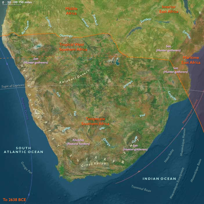
Geographic & Environmental Context
During the long swing from the Last Glacial Maximum to the Early Holocene, Southern Africa cohered as a single water-anchored world.
Two complementary spheres organized lifeways:
-
Temperate Southern Africa — the Cape littoral and fynbos, Namaqualand, Highveld grasslands, Drakensberg–Lesotho massif, Karoo, and the Maputo–Limpopo basins—where rising seas carved modern embayments and lagoons and river valleys remained fertile through climatic swings.
-
Tropical West Southern Africa — the Okavango Delta, Zambezi–Chobe–Cuando/Linyanti–Caprivi wetlands, the Etosha Pan system and Owambo/Cuvelai drains, and the fog-nourished Skeleton Coast—an aquatic–savanna frontier driven by flood pulses and ITCZ rains.
Together these belts formed a ridge–river–coast continuum: shell-rich coves and estuaries at the Cape, grassland and spring corridors inland, and pulsing floodplains and pans to the north.
Climate & Environmental Shifts
-
Bølling–Allerød (c. 14,700–12,900 BCE): Warmer, wetter conditions greened fynbos and Highveld grasslands; Okavango inundations broadened and Caprivi wetlands expanded; woodland belts thickened around Etosha and along the Owambo/Cuvelai drains.
-
Younger Dryas (c. 12,900–11,700 BCE): A brief cool–dry pulse contracted marsh edges and inland water bodies; coastal reliance intensified along the Cape and Namaqualand; floodplain use narrowed to perennial channels and levees.
-
Early Holocene (after 11,700 BCE): Climatic stabilization brought stronger summer rains in the north and reliable winter–spring moisture in the south; flood regimes regularized, lagoons matured, and grasslands recovered.
Subsistence & Settlement
A continent-spanning broad-spectrum portfolio matured, balancing semi-sedentary anchoring with seasonal mobility:
-
Coasts (Temperate south): Strandloper adaptations flourished—large shell middens formed along the Cape and Namaqualand, with fish, mussels, limpets, seals, and seabirds as staples. Semi-sedentary cove camps persisted near rich shorelines and estuaries; inland rounds targeted antelope and dug geophytes in fynbos and grasslands.
-
Floodplains & pans (Tropical west): Semi-recurrent levee camps followed fish runs (catfish/tilapia), flood-recession grazing of antelope, and riparian fruits. The Caprivi supported large wet-season encampments on high levees; Etosha margin hunts focused on springbok, zebra, oryx near permanent water; the Skeleton Coast remained a short-visit zone for carrion and shellfish.
Across both spheres, settlement knit together resource-rich nodes—coves, levees, springs, and rock shelters—reoccupied across generations.
Technology & Material Culture
Toolkits were light, durable, and tuned to water:
-
Microlithic bladelets and backed segments for composite arrows and spears.
-
Fish gorges, bone harpoons, woven basket traps, and stake weirs for estuary and floodplain capture.
-
Grinding slabs for wild plant processing; basketry and cordage for transport and drying racks.
-
Ostrich eggshell (OES) flasks for water carriage and abundant OES beads as exchange media.
-
Early rafts/dugouts likely in calm estuaries and distributaries.
Movement & Interaction Corridors
Mobility braided coasts, valleys, pans, and deltas into one exchange field:
-
Coastal corridors linked shell-midden coves with river mouths and inland passes to the Highveld and Drakensberg.
-
Flood-ridge “causeways” among Okavango palm islands, Caprivi levee paths, and Omuramba routes to Etosha organized pulse-following rounds.
-
The Maputo–Limpopo system and interior river valleys moved beads, pigments, dried fish, and hides between grassland and shore.
These routes created redundancy: when drought pinched a basin or a run failed, another habitat or partner camp stabilized supply.
Cultural & Symbolic Expressions
Symbolic life was vivid and place-anchored:
-
Rock art in Drakensberg and Cederberg shelters flourished—polychrome animal–human scenes, trance dances, and eland-linked ceremonies.
-
Shell middens functioned as ancestral markers at coastal landings; bead strings and pigment caches accumulated at island groves and pan-edge shelters in the north.
-
Seasonal feasts at fish peaks and flood-begin events renewed access rules to weirs, springs, and groves—ritual governance of resources.
Environmental Adaptation & Resilience
Security rested on storage + scheduling + multi-ecozone use:
-
Smoked/dried fish and meats, rendered fats, roasted seeds, and stored geophytes buffered lean months and Younger Dryas stress.
-
Seasonal anchoring at rich coasts and pulse-following mobility across wetlands and pans spread risk.
-
Edge-habitat focus (back-bar lagoons, riparian woods, pan margins) maximized predictable returns as conditions shifted.
Long-Term Significance
By 7,822 BCE, Southern Africa had stabilized as a water-anchored forager world: shell-midden communities lined the temperate coasts, and floodplain societies tuned lifeways to the Okavango–Caprivi–Etosha pulse. The shared operating code—portfolio subsistence, storage, seasonal anchoring with mobile spokes, bead-mediated exchange, and shrine-marked tenure—set the durable foundation for later Holocene traditions of coastal strandlopers, floodplain specialists, and, eventually, pastoral and farming horizons on the distant skyline.
Groups
Topics
Commodoties
- Fish and game
- Weapons
- Hides and feathers
- Gem materials
- Colorants
- Domestic animals
- Grains and produce
- Strategic metals
Subjects
Regions
Subregions
Related Events
Showing 10 events out of 69584 total
Years: 28577BCE - 7822BCE
Groups
Topics
Commodoties
- Fish and game
- Weapons
- Hides and feathers
- Gem materials
- Colorants
- Domestic animals
- Grains and produce
- Strategic metals
Subjects
Regions
Subregions