Balhae (Bohai, or Pohai), Kingdom of
State | Defunct
698 CE to 926 CE
Balhae is a mixed ethnic Korean and Mohe kingdom established in northern Korea and Manchuria after the fall of Goguryeo.
It exists during the North South States Period of Korea along with Unified Silla.
After Goguryeo's capital and southern territories fall to Unified Silla, Dae Jo-yeong, a man from Goguryeo whose father was Dae Jung-sang, establishes Jin, later called Balhae.
It is a successor state to Goguryeo.Balhae occupies southern parts of Manchuria (Northeast China) and Primorsky Krai, and the northern part of the Korean peninsula.
It is defeated by the Khitans in 926, and most of its northern territories are absorbed into the Liao Dynasty while the southern parts are absorbed into Goryeo.
Worlds
The Far East
View →Related Events
Showing 10 events out of 20 total
Northeastern Eurasia (7,821 – 6,094 BCE): Early Holocene — Salmon Rivers, Pottery Frontiers, and Forest–Sea Corridors
Geographic & Environmental Context
From the Upper Volga–Oka and Dnieper–Pripet belts across the Ob–Irtysh–Yenisei to the Amur–Ussuri and the Okhotsk–Bering rim (Sakhalin, Kurils, Kamchatka, Chukchi, northern Hokkaidō), Northeastern Eurasia formed a continuous world of taiga, big rivers, and drowned estuaries. Sea level rise reshaped river mouths into productive bays and tidal flats; inland, lake chains and marshlands multiplied along stabilized watersheds.
Climate & Environmental Shifts
The Holocene thermal optimum brought warmer, wetter, and more even seasonality.
-
Taiga expansion (birch–pine–spruce) advanced north; mixed forests with hazel spread south.
-
Rivers (Volga, Dnieper, Ob, Yenisei, Amur) ran full but steady; estuaries and kelp-lined nearshore waters boomed.
-
Rising seas drowned river mouths, creating ideal passages for anadromous salmon and shellfish-rich flats.
These conditions favored semi-sedentary clustering at confluences, terraces, and tidal margins.
Subsistence & Settlement
A pan-regional broad-spectrum, storage-oriented foraging system matured:
-
East Europe (Upper Volga–Oka, Dnieper, Upper Dvina, Pripet): semi-sedentary river villages with pit-houses focused on sturgeon/pike, elk/boar, hazelnuts, and berries; net-weirs and fish fences anchored seasonal peaks.
-
Northwest Asia (Ob–Irtysh–Yenisei, Altai–Minusinsk): riverine hamlets hunted elk, reindeer, boar; salmon and sturgeon fisheries underwrote wintering; hearth clusters and storage pits marked long occupation.
-
Northeast Asia (Lower/Middle Amur–Ussuri, Okhotsk littoral, Sakhalin–Kurils–Hokkaidō, Kamchatka, Chukchi): salmon-focused semi-sedentism at confluences and tidal flats; smoke-drying and oil rendering produced high-calorie stores; broad-spectrum rounds added elk/reindeer, waterfowl, intertidal shellfish, and seasonal pinnipeds.
Across the span, households returned to the same terraces, bars, and headlands, building place-memory landscapes suited to storage and exchange.
Technology & Material Culture
This was the first great pottery horizon of the north, paired with refined fishing and woodcraft:
-
Early ceramics (7th millennium BCE onward): fiber-/plant- or grit-tempered jars spread in the Upper Volga–Oka, Ob–Yenisei, and Lower Amur, used for boiling fish/meat, fat rendering, and storage; soot-blackened cookpots are typical in the Amur basin.
-
Ground-stone adzes/axes drove canoe- and house-carpentry; composite harpoons, barbed bone hooks, gorges, net sinkers/floats, and stake-weirs scaled mass capture.
-
Personal ornaments of shell, amber, antler, and drilled teeth traveled widely; ochre accompanied burials.
Movement & Interaction Corridors
Waterways made a braided superhighway:
-
Volga–Oka–Dnieper–Dvina canoe circuits linked taiga, marsh, and lake belts; portages stitched watersheds and spread pottery styles.
-
Ob–Irtysh–Yenisei integrated western and central Siberia; the Ural corridor connected taiga foragers with the forest-steppe of Europe.
-
Amur–Sungari tied interior to coast; short-hop voyaging along Sakhalin–Kurils–Hokkaidō moved shell, stone, and ideas; over-ice travel on inner bays persisted in winter.
These lanes provided redundancy—if a salmon run failed locally, neighboring reaches or coastal banks supplied substitutes.
Cultural & Symbolic Expressions
A river-and-animal cosmology left vivid traces:
-
Rock art fields (Minusinsk, Tomsk, Karelia–Alta–Finland) depict elk, fish, boats, hunters, and ritual poses.
-
First-salmon rites are inferred in patterned discard and special hearths; bear and sea-mammal treatments suggest respect for “animal masters.”
-
Cemeteries with ochre, antler and stone grave goods, and—in the northeast—pots in burials formalized ancestry tied to landing places and weirs.
Waterfront mounds and shell/bone-rich zones functioned as ancestral monuments.
Environmental Adaptation & Resilience
Resilience rested on storage + mobility + multi-habitat rounds:
-
Smoke-dried fish, rendered oils, roasted nuts/berries, and cached meats carried camps through winter.
-
River–coast–upland scheduling diversified risk across salmon runs, waterfowl peaks, reindeer/elk migrations, and shellfish seasons.
-
Weir and landing-place tenure, reinforced by ritual, regulated pressure on key stocks and limited conflict.
Long-Term Significance
By 6,094 BCE, Northeastern Eurasia had consolidated into a storage-rich taiga and salmon civilization without agriculture—large, long-lived villages on river terraces and tidal flats; early pottery embedded in daily subsistence; and canoe/ice corridors knitting thousands of kilometers.
These habits—fat economies, ceramic storage, engineered fisheries, and shrine-marked tenure—prepared the ground for larger pit-house villages, denser coastal networks, and, later, steppe–taiga exchanges that would link this northern world to Eurasia at large.
Northeast Asia (7,821 – 6,094 BCE): Early Holocene — Salmon Villages, First Pottery Expansion, and Forest Mosaics
Geographic and Environmental Context
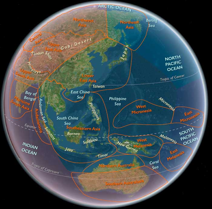
Northeast Asia includes eastern Siberia east of the Lena River to the Pacific, the Russian Far East (excluding the southern Primorsky/Vladivostok corner), northern Hokkaidō (above its southwestern peninsula), and extreme northeastern Heilongjiang.
-
Anchors: the Lower/Middle Amur and Ussuri basins, the Sea of Okhotsk littoral (Sakhalin, Kurils), Kamchatka, the Chukchi Peninsula (with Wrangel Island offshore), northern Hokkaidō, and seasonally emergent shelves along the Bering Sea and northwest Pacific.
Formation of Ancient Paleosiberians and Proto-Amerindian Isolation
By the early Holocene, the Ancient Paleosiberians (AP) had become a distinct population across parts of northeastern Siberia. A key representative comes from a ~9,800 BCE individual from the Kolyma River, whose genome reveals close affinity to the ancestors of Native Americans.
At this stage, the populations ancestral to Native Americans and those remaining in Northeast Asia were still closely related, sharing a mixed ancestry composed of:
-
Ancient North Eurasian (ANE) components of largely West Eurasian origin
-
A deeply diverged East Eurasian lineage, related to but separate from modern East Asians, which had split from their ancestors around 25,000 years ago
This period marks the height of genetic continuity between Siberian and proto-American populations, just before their historical trajectories diverged.
Climate & Environmental Shifts
-
Early Holocene stability: fuller taiga expansion, high river discharges, productive estuaries and nearshore kelp forests.
-
Sea level rising toward modern shorelines created drowned river-mouths ideal for salmon runs.
Subsistence & Settlement
-
Salmon-focused semi-sedentism: repeated aggregation at confluences and tidal flats; smoke-drying and oil rendering supported storage.
-
Broad-spectrum foraging: elk/reindeer, waterfowl, nuts/berries, intertidal shellfish; pinnipeds seasonally.
Technology & Material Culture
-
Early pottery (fiber- and plant-tempered) spread throughout the Lower Amur and coastal basins; soot-blackened cooking jars for fish broths.
-
Ground-stone adzes for woodworking and hollowing logs; composite harpoons; barbed bone fishhooks; net sinkers and floats.
-
Personal ornaments in shell/antler; ochre-rubbed burials.
Movement & Interaction Corridors
-
Amur–Sungari waterway linked interior and coast; short-hop voyaging along Sakhalin–Kurils–Hokkaidō.
-
Seasonal over-ice travel persisted on inner bays; summer canoe movement expanded.
Cultural & Symbolic Expressions
-
First-salmon rites inferred from patterned discard; bear and sea-mammal treatment suggests ritual respect for “animal masters.”
Environmental Adaptation & Resilience
-
Storage + mobility strategy buffered lean runs; multi-habitat rounds (river–coast–upland) diversified risk.
Transition
Toward 6,094 BCE, stable salmon ecologies and expanding early pottery paved the way for larger pit-house villages and richer coastal networks.
Northeastern Eurasia (6,093 – 4,366 BCE): Middle Holocene — Rivers of Salmon, Forests of Memory, and the First Great Pottery Webs
Geographic & Environmental Context
During the Middle Holocene, Northeastern Eurasia—stretching from the Ural Mountains and West Siberian rivers through the Yenisei–Lena basins to the Amur Valley, Okhotsk coast, Sakhalin, Kamchatka, and northern Hokkaidō—was a vast world of taiga, tundra, and riverine abundance.
The Hypsithermal climatic optimum transformed this immense territory into a richly productive mosaic of mixed forest, grass-steppe, and salmon-bearing rivers.
In the west, the Ob–Irtysh and Yenisei basins anchored stable fishing and forest economies; eastward, the Amur and Okhotsk corridors linked river valleys to the Pacific; northward, glacial meltwaters fed chains of lakes and wetlands teeming with life.
These were the northern heartlands of the world’s great forager–fishers, and the first to organize wide ceramic, trade, and symbolic networks that prefigured the coming age of pastoralism and metallurgy farther south.
Climate & Environmental Shifts
The Hypsithermal warm maximum (c. 7000–4000 BCE) brought milder winters, longer growing seasons, and higher precipitation across most of Siberia and the Russian Far East.
-
Permafrost retreated, opening new valleys to vegetation and settlement.
-
Dense taiga forests spread northward, dominated by birch, pine, and larch, while broadleaf trees (oak, elm, linden) colonized the southern basins.
-
Rivers and lakes stabilized, producing predictable salmon and sturgeon runs, as well as flourishing populations of elk, bear, and beaver.
This stable climatic envelope underwrote population growth and increasingly permanent settlement—an ecological balance that would endure for millennia.
Subsistence & Settlement
Northeastern Eurasian societies thrived on diversified, river-centered economies that balanced abundance with mobility.
-
In Northwest Asia (the Ob–Yenisei–Altai region), pit-house villages lined river terraces; fishing intensified with weirs, harpoons, and net traps. Elk and reindeer hunting remained vital, supplemented by nuts and berries.
-
In Northeast Asia (the Amur, Sakhalin, Kamchatka, and Hokkaidō zones), large semi-sedentary river and coastal villages emerged, often rebuilt repeatedly to form deep archaeological layers. Salmon runs, seal rookeries, and nut groves sustained dense populations.
-
Storage technology—ceramic containers, smokehouses, and drying racks—enabled year-round residency in many locales.
-
Dog traction facilitated winter mobility; canoes and rafts made rivers and coasts into highways of exchange.
The result was an unparalleled synthesis: fishing societies as populous and materially rich as early farmers, living by rhythm rather than scarcity.
Technology & Material Culture
This epoch saw the great flowering of pottery and woodworking across the northern world:
-
Pottery spread from the western forest-steppe to the Pacific, diversifying into Narva, Comb Ware, fiber-tempered, and corded-impressed forms. Large storage vessels enabled boiling, fermenting, and preserving fish and nuts.
-
Ground-stone tools—adzes, axes, and chisels—supported extensive carpentry, housebuilding, and canoe production.
-
Harpoons, toggling spearheads, and net weights attest to mastery of aquatic technology.
-
Bone and antler craft achieved aesthetic refinement, producing pendants, figurines, and ceremonial objects.
-
In the east, dugout canoes became standard, while obsidian from Kamchatka and Hokkaidō circulated widely.
Across this immense domain, the pottery horizon became the connective tissue of culture—the material sign of a shared northern world.
Movement & Interaction Corridors
The rivers and coasts of Northeastern Eurasia formed a single network of movement and exchange:
-
The Ob–Yenisei–Lena–Amur trunklines carried pottery styles, exotic stones, and ideas over thousands of kilometers.
-
The Altai–Sayan passes and Ural valleys linked Siberia to the steppes and Central Asia, transmitting tools, pigments, and eventually herd animals.
-
Eastward, the Okhotsk Sea and Amur estuaries functioned as maritime corridors, with the Kuril–Sakhalin–Hokkaidō chain acting as an “island ladder” for shell, obsidian, and cultural traffic.
These waterborne routes united forest, tundra, and coast into one of the world’s first truly transcontinental ecological and cultural systems.
Cultural & Symbolic Expressions
Material abundance nurtured complex symbolic and social traditions:
-
Rock art—especially in the Altai, Yenisei, and Amur regions—depicted elk, reindeer, fish, solar disks, and boats, blending hunting, shamanism, and cosmology.
-
Cemeteries with ochre, pottery, and ornaments mark the earliest formalized mortuary rites across the northern taiga.
-
Feasting middens and shell caches in the Amur and Hokkaidō zones point to social gatherings centered on salmon harvests.
-
Longhouse and pit-house clusters suggest lineage-based settlement, with spiritual ties to ancestral places reinforced through burial and ritual deposition.
These expressions reveal communities already possessing a deep sense of ancestry, landscape, and cyclical time—the spiritual architecture of later northern traditions.
Environmental Adaptation & Resilience
Survival in this vast region depended on balance, storage, and mobility:
-
Food storage (dried fish, rendered oils, and nuts) and seasonal mobility mitigated the risk of failed runs or harsh winters.
-
Multi-resource economies—hunting, fishing, gathering—provided redundancy across ecosystems.
-
Domestic dogs and canoes extended range and flexibility.
-
Settlement clustering along ecotones (forest–river–coast) allowed access to multiple biomes.
These adaptive systems ensured that even in years of climatic stress, human communities remained secure, their resilience rooted in environmental intelligence rather than technological excess.
Long-Term Significance
By 4,366 BCE, Northeastern Eurasia had become a continent of stable, populous, and interconnected foraging societies, its rivers and coasts lined with semi-permanent villages and its pottery traditions spanning thousands of kilometers.
The Ob–Amur cultural continuum foreshadowed later Eurasian steppe–taiga interactions, while the Amur–Hokkaidō corridor anticipated the maritime expansions of the late Neolithic and Bronze Age.
This was the age of rivers and salmon, of vast communication without cities—a world where exchange, artistry, and community thrived without agriculture.
Its enduring legacy was a model of resilient abundance, proving that civilization could begin not only in fields, but also in forests and flowing water.
Northeast Asia (6,093 – 4,366 BCE): Middle Holocene — Big Salmon, Big Villages, and Deepening Pottery Traditions
Geographic and Environmental Context
Northeast Asia includes eastern Siberia east of the Lena River to the Pacific, the Russian Far East (excluding the southern Primorsky/Vladivostok corner), northern Hokkaidō (above its southwestern peninsula), and extreme northeastern Heilongjiang.
-
Anchors: Amur–Ussuri terraces and levees, Okhotsk embayments, Sakhalin lagoons, Kamchatka river mouths, Hokkaidō shell-midden coasts.
Beringian Standstill and the End of a Genetic Configuration
During this interval, a subset of Proto-Amerindian Paleo-Siberians entered a prolonged phase of relative genetic isolation, often referred to as the Beringian standstill. For several millennia, these populations remained largely cut off from other Asian groups.
This isolation allowed for:
-
Independent genetic drift
-
Local adaptation to Arctic and sub-Arctic environments
-
The emergence of distinct phenotypic variation
Importantly, this genetic configuration ceased to exist within Siberia itself soon after this period. While Proto-Amerindian groups moved eastward and eventually into the Americas, Siberia underwent further demographic transformation.
Climate & Environmental Shifts
-
Hypsithermal warm maximum: dense mixed taiga, long ice-free seasons, exceptionally large salmon runs.
Subsistence & Settlement
-
Large pit-house villages on raised river benches; repeated rebuilds created deep cultural layers.
-
Seasonal satellite camps at anadromous fish bottlenecks, seal haul-outs, and berry patches.
Technology & Material Culture
-
Diversified ceramic styles (corded/impressed), larger storage vessels; ground-stone woodworking kit; broad weir/trap systems; refined toggling harpoons.
-
Dugout canoes became routine for transport and net sets; dog traction in winter travel.
Movement & Interaction Corridors
-
Canoe trunklines along the Amur and Okhotsk inner coasts; Kuril–Hokkaidō “island ladder” facilitated obsidian and shell exchange.
Cultural & Symbolic Expressions
-
Longhouse/pit-house clustering hints at lineage districts; feasting middens with prestige shell/bead caches; ochre and grave goods in formal cemeteries.
Environmental Adaptation & Resilience
-
High-capacity storage (smoked/dried salmon, rendered oils) enabled semi-sedentary lifeways; diversified procurement (elk, nuts, waterfowl) hedged against run failure.
Transition
By 4,366 BCE, the region supported durable river–coast village systems and ceramic traditions poised for late Neolithic maritime networking.
East Asia (909 BCE – 819 CE): Empires of the Earth and Sea — Dynastic Order, Steppe Frontiers, and the Silk Roads
Regional Overview
From the Yellow River to the Pacific and from the Mongolian steppe to the Tibetan Plateau, East Asia during the first millennium BCE through the early centuries CE was a continent of convergences.
Agrarian states and dynastic empires took root along the river plains, while nomadic confederations and frontier kingdoms moved across the grasslands and highlands that rimmed them.
Maritime and overland corridors—Silk Roads on land, monsoon routes at sea—bound together worlds as different as the Confucian court and the shamanic tent.
By the early Tang centuries (7th–8th CE), East Asia stood as a fully integrated macro-region, its heartland in the Chinese empires, its limbs stretching across Korea, Japan, and the nomadic and oasis realms of Central and Inner Asia.
Geography and Environment
East Asia straddles four great ecological zones:
-
The riverine basins of the Yellow and Yangtze Rivers, sustaining dense agrarian populations.
-
The steppe–desert belt of Mongolia and northern China, cradle of mounted nomadism.
-
The Himalayan and Tibetan highlands, where pastoralism and Buddhism would later entwine.
-
The maritime rim—Korea, Japan, Taiwan, and the coastal provinces of China—where oceanic and continental influences met.
Climate oscillated between colder, drier pulses and warmer, wetter intervals, influencing both dynastic expansion and steppe migrations.
The East Asian monsoon determined not only crop yields but also trade winds, linking agrarian cycles to navigation across the Yellow, East China, and South China Seas.
Societies and Political Developments
The Agrarian Heartlands
The Zhou dynasty (1046–256 BCE) initiated the feudal order that structured Chinese governance for centuries: hierarchies of lords, bureaucrats, and ritual specialists sustained by agricultural tribute.
Its decline gave rise to the Warring States era, when states such as Qin, Chu, and Zhao transformed warfare, irrigation, and administration.
The Qin dynasty (221–206 BCE) unified the empire under a legalist system, standardizing weights, measures, and the written script.
The Han dynasty (206 BCE–220 CE) institutionalized imperial bureaucracy and expanded agriculture through canal and dike construction, integrating frontier territories from Korea to Yunnan.
Later dynasties—the Three Kingdoms, Jin, and the Northern and Southern Dynasties—continued to compete for the central plain until the Tang (618–907 CE) restored durable unity and cultural brilliance.
The Northern and Western Frontiers
Beyond the Great Wall, nomadic confederations—the Xiongnu, Xianbei, and later the Türkic Khaganates—dominated the steppe.
Their mobility and horse mastery reshaped trade and war; their diplomacy alternated between alliance and incursion.
The Tibetan Plateau, unified under the Tubo Empire (7th–9th CE), became a trans-Himalayan power controlling routes to India and Central Asia.
In the Tarim Basin, oasis kingdoms such as Khotan, Turpan, and Kucha flourished as cosmopolitan waypoints on the Silk Road.
The Maritime Rim
Across the seas, Korea evolved through the Gojoseon and Three Kingdoms (Goguryeo, Baekje, Silla), culminating in Silla’s unification of the peninsula in the late 7th century CE.
Japan moved from the agrarian Yayoi period into the Kofun and Asuka ages, adopting writing, Buddhism, and bureaucratic models from the continent.
Taiwan’s Austronesian peoples remained within a maritime network stretching toward the Philippines and Southeast Asia, linking East Asia to the Pacific world.
Economy and Exchange
Agriculture—millet and wheat in the north, rice in the south—formed the imperial base, supported by state-run granaries and canal transport.
Artisan production and trade expanded through both overland and maritime routes:
-
The Silk Road carried textiles, jade, and lacquerware westward, returning with glass, horses, and precious metals.
-
The maritime circuits connected Guangzhou and the lower Yangtze with India, Southeast Asia, and Arabia, foreshadowing the oceanic commerce of later centuries.
Iron plows, blast furnaces, and advanced irrigation sustained population growth.
Urban markets in Chang’an, Luoyang, and coastal ports transformed consumption and social mobility, while border trade with nomads exchanged silk for horses, ensuring both sides’ survival.
Technology and Material Culture
Innovation defined the region:
-
Iron and steel tools revolutionized agriculture and warfare.
-
Papermaking (Han dynasty) and later printing (Tang) reshaped knowledge transmission.
-
Compass prototypes, sternpost rudders, and bulkheaded ships made China’s sailors the engineers of the early world ocean.
-
Bronze and lacquer arts, porcelain experiments, and calligraphy turned everyday materials into expressions of order and beauty.
Steppe metallurgy, Tibetan textiles, and Korean–Japanese bronze mirrors illustrate the dynamic exchange between frontier and heartland.
Belief and Symbolism
East Asia’s spiritual landscape was a triad of Confucian order, Daoist nature, and Buddhist transcendence, each blending with indigenous shamanic and animist traditions.
The Mandate of Heaven linked cosmic harmony to political legitimacy; rulers governed as intermediaries between Earth and Sky.
Buddhism, introduced via Central Asia in the first centuries CE, merged with local pantheons to produce new art, literature, and architecture—from Yungang’s cave temples to Nara’s wooden halls.
In the steppe, sky cults and ancestral rites sanctified mobility and kinship; in the islands, nature spirits, kami, and bodhisattvas intertwined.
Movement and Interaction Corridors
The Silk Road traversed deserts and mountains from Chang’an to Samarkand, distributing goods and ideas.
Parallel steppe corridors linked Mongolia to Eastern Europe, carrying mounted warriors and technologies westward.
The maritime highways—through the Korean Strait, Taiwan Strait, and South China Sea—connected East Asia to Southeast Asia and the Indian Ocean.
Collectively these arteries made the region not an isolated terminus but a circulatory system of the Old World.
Adaptation and Resilience
Environmental and political shocks—floods, nomadic invasions, dynastic collapse—were countered through infrastructural resilience: canals, dikes, and social hierarchies distributed risk.
In frontier zones, mixed economies (pastoral + agrarian) absorbed climate stress.
Maritime redundancy ensured trade continuity even when overland routes faltered.
Cultural syncretism itself became an adaptive strategy: by integrating outside ideas, East Asia renewed rather than ruptured its civilizational fabric.
Regional Synthesis and Long-Term Significance
By 819 CE, East Asia had matured into one of the world’s great civilizational ecosystems—a dynamic equilibrium of empire and frontier, plow and saddle, brush and sail.
Its Maritime sphere (China–Korea–Japan–Taiwan) perfected bureaucratic and technological systems that would radiate outward through the seas, while its Upper sphere (Mongolia–Tibet–Xinjiang) remained the strategic high ground linking China to the heart of Eurasia.
Together they formed a single macro-region defined by circulation: of goods, of peoples, of cosmologies.
Their differences—continental and oceanic, sedentary and nomadic, Confucian and shamanic—were not contradictions but complements.
Thus, the natural division of East Asia into its Maritime and Upper subregions mirrors its very logic: a world balanced between the order of the land and the freedom of the wind.
Maritime East Asia (909 BCE – CE 819): Imperial Centers, Maritime Trade, and Cultural Flourishing
Geographic and Environmental Context
Maritime East Asia includes eastern China, Taiwan, the Korean Peninsula, and Japan.
-
The subregion spans fertile river valleys such as the Yangtze and Yellow River basins, mountainous interiors, and extensive coastal plains.
-
Offshore, the East China Sea, Yellow Sea, and Sea of Japan connect the mainland to island territories, while major straits such as the Tsushima and Taiwan Straits serve as maritime gateways.
Climate and Environmental Shifts
-
The East Asian monsoon dominates the seasonal cycle, bringing wet summers and cold, dry winters to the mainland and peninsulas.
-
Periodic climatic fluctuations, including colder intervals in the early first millennium CE, influenced agricultural productivity and population distribution.
-
Typhoons posed recurring threats to coastal settlements and maritime activity.
Societies and Political Developments
-
In China, this period encompassed the Eastern Zhou, Qin, and Han dynasties, followed by the Three Kingdoms, Jin, and the Northern and Southern Dynasties, leading into the Tang dynasty by the early 8th century CE.
-
Korea saw the emergence and consolidation of the Three Kingdoms—Goguryeo, Baekje, and Silla—followed by Silla’s unification of most of the peninsula in the late 7th century CE.
-
Japan transitioned from the Yayoi agricultural period to the Kofun and Asuka periods, with increasing state centralization and cultural borrowing from the mainland.
-
Taiwan was home to Austronesian-speaking societies linked to maritime networks extending into Southeast Asia and the Pacific.
Economy and Trade
-
Agriculture, especially rice cultivation in paddy fields, formed the economic base, supplemented by wheat, millet, and barley in northern zones.
-
Silk, lacquerware, ceramics, and metal goods were major exports from China to Central Asia, Southeast Asia, and beyond.
-
Maritime trade linked the Chinese and Korean coasts to Japan, Taiwan, and Southeast Asia, moving goods such as textiles, tools, salt, and luxury items.
-
Urban markets in capitals like Chang’an and Luoyang became hubs of domestic and international commerce.
Subsistence and Technology
-
Advanced irrigation systems supported high-yield rice agriculture.
-
Iron and steel production expanded, improving agricultural tools, weapons, and construction.
-
Shipbuilding technology progressed, with larger ocean-going vessels facilitating long-distance trade.
-
Written scripts, including Chinese characters, were adopted or adapted in Korea and Japan.
Movement and Interaction Corridors
-
Overland routes connected Lower East Asia to Central Asia via the Silk Road, facilitating exchange of goods, ideas, and technologies.
-
Maritime routes across the Yellow and East China Seas enabled diplomatic, cultural, and economic ties between China, Korea, and Japan.
-
Coastal navigation linked Taiwan to the Fujian and Guangdong coasts, forming part of a broader Austronesian maritime sphere.
Belief and Symbolism
-
Confucianism, Daoism, and Buddhism shaped governance, art, and daily life, with Buddhism spreading from China into Korea and Japan.
-
Monumental architecture, including palace complexes, pagodas, and tomb mounds, reflected political authority and religious devotion.
-
Decorative arts often carried symbolic motifs representing prosperity, protection, and cosmic order.
Adaptation and Resilience
-
Regional specialization in crops and crafts reduced dependence on any single resource.
-
State-managed granaries and transportation networks helped buffer against famine.
-
Cross-cultural diplomacy maintained stability and trade even during periods of political fragmentation.
Long-Term Significance
By CE 819, Maritime East Asia had become a dynamic nexus of political power, cultural innovation, and maritime exchange, influencing the economic and intellectual life of much of Eurasia.
Maritime East Asia (676–819 CE): Cultural Flourishing and State Consolidation
Between 676 CE and 819 CE, Maritime East Asia—comprising lower Primorsky Krai, the Korean Peninsula, the Japanese Archipelago below northern Hokkaido, Taiwan, and southern, central, and northeastern China—experiences significant political stabilization, cultural flowering, and administrative refinement.
Tang Dynasty Stability and Cultural Achievements
China’s Tang Dynasty (618–907), despite facing the severe An Lushan Rebellion and subsequent weakening of central authority in the late eighth century, continues to be marked overall by significant cultural and technological advancements. During this period, Chinese ceramic ware shows the earliest evidence of cobalt use, highlighting advancements in craftsmanship and material technology.
The Tang period remains a cultural pinnacle, demonstrating extraordinary literary, artistic, and scholarly achievements. The Tang capital at Chang'an continues to thrive as a cosmopolitan hub of international trade, cultural exchange, and intellectual pursuit, solidifying China's historical role as a major civilizational center.
Consolidation and Cultural Prosperity in Japan
In Japan, imperial and bureaucratic reforms initiated during earlier periods are further consolidated in 701 with the establishment of the Taiho-ryoritsu (Taiho Code). This code, influenced by Confucian and Chinese models, introduces refined penal provisions, administrative structuring, and civil service examination systems based on Confucian classics. Although designed for merit-based governance, aristocratic lineage remains dominant for high positions.
The reforms establish a permanent imperial capital at Heijokyo (Nara) in 710, modeled on China's Tang capital, Chang'an. Nara quickly becomes Japan's first true urban center, with a population reaching approximately two hundred thousand, including a large bureaucratic class of civil servants. This capital shift marks the beginning of the culturally rich Nara period (710–794), during which Chinese cultural influences permeate deeply into Japanese society, politics, and religion.
The Flourishing of Balhae in Korea and Manchuria
North of the Korean Peninsula, the kingdom of Balhae emerges as a prominent state, strongly influenced by Tang China's political structure and cultural practices. Balhae actively engages in educational exchanges with Tang China, sending students to learn from Tang institutions, which significantly shapes its administrative systems and cultural identity. Recognized by China as a "flourishing land in the East," Balhae develops a sophisticated civilization that blends indigenous practices with Chinese influences.
Silla’s Golden Age
On the Korean Peninsula, Unified Silla experiences its golden age after consolidating control over most of the peninsula. The period sees extensive urban development, administrative standardization, and flourishing Buddhist art and architecture, reflecting the broader East Asian cultural milieu of the era. Silla maintains diplomatic ties with Tang China and Japan, facilitating vibrant cultural and commercial exchanges throughout Lower East Asia.
Legacy of the Age: A Period of Integration and Advancement
The era from 676 to 819 CE is defined by political stabilization, administrative sophistication, and cultural flourishing across Maritime East Asia. Through sustained exchanges and shared influences, China, Korea, and Japan each experience profound developments that shape their respective cultural and historical trajectories, setting foundations for subsequent regional dynamics.
Balhae models its central government even more directly on Tang systems than does Silla and sends many students to Tang schools.
Balhae culture melds indigenous and Tang influences, and its level of civilization is high enough to merit the Chinese designation as a "flourishing land in the East."
There are many contacts between Silla and Tang China, as large numbers of students, officials, and monks travel to China for study.
In 682 Silla sets up a national Confucian academy to train high officials and later institutes a civil service examination system modeled on that of the Tang.
The earliest extant recorded mention of Balhae comes from the Old Book of Tang, which was compiled between 941 to 945.
Southern Manchuria and northern Korea were previously the territory of Goguryeo, one of the Three Kingdoms of Korea.
Goguryeo had fallen to the allied forces of Silla and the Tang Dynasty in 668.
The Tang had annexed much of western Manchuria, while Silla has unified the Korean peninsula south of the Taedong River and become Unified Silla.
In the confusion of uprising by the Khitan against the Tang, Dae Jung-sang, a former Goguryeo official, who is a leader of remnants people of Goguryeo, allies with Geolsa Biu, a leader of Mohe, and rises against the Tang in 698.
After Dae Jung-sang’s death, his son Dae Jo-yeong, a former Goguryeo general, succeeded his father.
Geolsa Biu dies in battle against the Tang army led by the general Li Kaigu.
Dae Jo-yeong manages to escape outside of the Tang controlled territory with the remaining Goguryeo and Mohe soldiers.
He defeats the pursuing army sent by Wu Zetian at the Battle of Tianmenling, which enables him to establish the state of Balhae in the former region of Yilou.