France (French republic); the Fifth Republic
State | Active
1958 CE to 2057 CE
Worlds
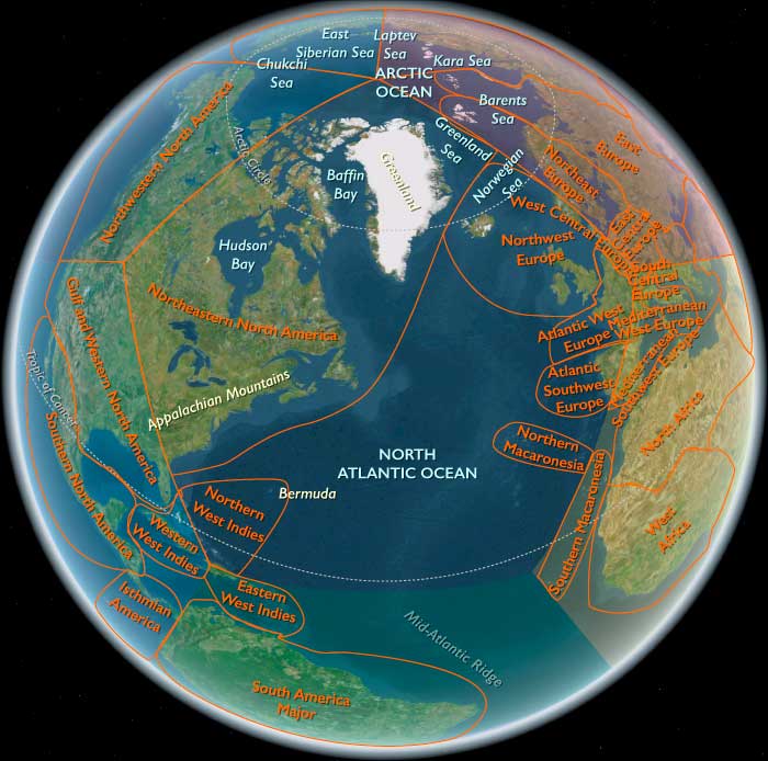
The Atlantic Lands
View →Related Events
Showing 10 events out of 42 total
East Melanesia (820–1971 CE): Interactions, Colonization, and Independence
Political and Military Developments
Chiefdoms and Inter-Island Alliances
From 820 CE onward, East Melanesia experienced significant growth of complex chiefdoms, notably in Fiji, Vanuatu, and the eastern Solomon Islands. These chiefdoms formed intricate networks of alliances and rivalries, reflecting advanced political organization and military strategies.
European Contact and Colonization
European explorers, beginning in the 17th century, profoundly impacted East Melanesia. Initial exploration was followed by colonization, particularly by British and French powers. New Caledonia became a French colony in 1853, while Fiji was ceded to Britain in 1874, and Vanuatu was jointly administered by Britain and France from 1906 as the New Hebrides Condominium.
Road to Independence
During the 20th century, nationalist movements intensified across East Melanesia. Fiji gained independence in 1970, and later Vanuatu in 1980, highlighting significant shifts towards self-governance and regional sovereignty.
Economic and Technological Developments
Agricultural Innovation and Trade
Agricultural techniques continued evolving, with innovations in crop diversification, cultivation methods, and trade expansion. Copra (dried coconut meat), sandalwood, and sugar became significant economic commodities, fostering regional and global trade.
Technological Integration and Modernization
European colonization introduced new technologies, including metal tools, firearms, and improved shipbuilding techniques. These advancements altered economic practices, transportation, and military dynamics within the region.
Cultural and Artistic Developments
Syncretism and Cultural Adaptation
Cultural traditions adapted and syncretized indigenous Melanesian practices with European influences. Artistic expression, including traditional carvings, dances, and music, incorporated external elements, reflecting evolving cultural identities.
Preservation of Indigenous Traditions
Despite colonial pressures, many indigenous cultural traditions were preserved and revitalized. Ceremonial practices, storytelling, and traditional knowledge systems remained critical components of community cohesion and identity.
Social and Religious Developments
Impact of Christianity
Missionary activities beginning in the 19th century profoundly reshaped religious landscapes, introducing Christianity widely throughout East Melanesia. This led to the blending of indigenous religious practices with Christian doctrines.
Social Changes and Community Structures
Colonialism significantly influenced social structures, introducing Western legal systems, education, and governance models. Nevertheless, traditional community organization, chiefly hierarchies, and kinship networks continued playing vital roles.
Long-Term Consequences and Historical Significance
From 820 to 1971 CE, East Melanesia underwent transformative changes through internal dynamics, external influences, and colonization. The resulting synthesis of traditional and introduced elements profoundly shaped contemporary political structures, economic foundations, cultural identities, and social systems, laying critical groundwork for the post-colonial era.
Polynesia (1828–1971 CE)
Missions, Colonial Rule, Nuclear Era, and Islander Revivals
Geography & Environmental Context
Polynesia in this framework consists of three fixed subregions:
-
North Polynesia: the Hawaiian Islands except the Big Island of Hawai‘i (i.e., O‘ahu, Maui, Kaua‘i, Moloka‘i, Lāna‘i, Ni‘ihau, Kaho‘olawe) plus Midway Atoll.
-
West Polynesia: the Big Island of Hawai‘i, Tonga, Samoa, Tuvalu, Tokelau, the Cook Islands, and French Polynesia (Tahiti, Society Islands, Tuamotus, Marquesas).
-
East Polynesia: Pitcairn Island and Rapa Nui (Easter Island).
Across these archipelagos, tropical trade-wind climates prevail, with cyclone belts affecting Samoa, the Cooks, Tuvalu, and Tokelau; volcanic high islands (Hawai‘i, Tahiti, Savai‘i, Upolu) contrast with low coral atolls (Marsh–Tuamotu chains). Reef fisheries, taro and breadfruit groves, and limited freshwater lenses defined ecological limits, while population growth and 20th-century militarization increased pressure on land and lagoons.
Climate & Environmental Shifts
The late 19th century saw variable El Niño–Southern Oscillation (ENSO) events that brought droughts to atolls and heavy rains to high islands. Cyclones periodically devastated coastal settlements and breadfruit groves. In the mid-20th century, runway construction, urbanization, and lagoon dredging altered local hydrology, while radioactive fallout (from French tests in French Polynesia from 1966 and upwind U.S. tests in Micronesia earlier) entered regional anxiety and health debates.
Subsistence & Settlement
-
High islands maintained mixed gardens (taro, yams, bananas), breadfruit orchards, pigs, and intensive reef fishing; plantation sectors (sugar, pineapple in Hawai‘i; copra in French Polynesia, the Cooks, Tuvalu, Tokelau) linked families to cash.
-
Atolls relied on coconuts, preserved breadfruit, pulaka/taro pits, and lagoon fisheries, supplemented by remittances and colonial rations in bad years.
-
Urban hubs—Honolulu (North Polynesia), Apia and Nuku‘alofa (West Polynesia), Pape‘ete (French Polynesia), and Hanga Roa (Rapa Nui)—grew with missions, administration, shipping, and (after WWII) air travel and tourism.
Technology & Material Culture
Mission schools and printing presses spread literacy; schooners and later steamships knit archipelago economies. After 1900, outboard motors, radios, and concrete housing transformed daily life; airfields (e.g., O‘ahu, Tahiti, Rarotonga, Faleolo) opened long-haul links. Material culture hybridized: tapa and fine mats continued alongside cotton cloth; canoe carving persisted while aluminum boats proliferated; church architecture stood beside fale and hale vernacular.
Movement & Interaction Corridors
-
Labor and migration: 19th-century contract labor fed plantations (especially Hawai‘i), followed by 20th-century migration to New Zealand, Australia, and the U.S.; seasonal inter-island voyaging persisted for family, church, and trade.
-
Shipping and air routes: Honolulu and Pape‘ete became trans-Pacific nodes; Apia and Rarotonga connected West Polynesia to Auckland and Sydney.
-
War corridors: WWII militarized North and West Polynesia; bases, runways, and garrisons left long-term economic and environmental footprints.
Cultural & Symbolic Expressions
Christianity became dominant across Polynesia, but customary authority (chiefly systems, matai titles, kāhui ariki)and ritual continued, often braided with church life. Hula, ‘ori Tahiti, siva Samoa, and haka (in nearby Aotearoa/NZ) flourished in new performance circuits, while language retention movements gathered momentum after WWII. In East Polynesia, Pitcairn’s Bounty-descendant culture and Rapa Nui’s rongorongo legacy and moai landscape shaped strong place-based identities.
Environmental Adaptation & Resilience
Atoll communities relied on breadfruit fermentation pits, cisterns, and inter-island kin networks for famine relief. Reef tenure and customary closures (e.g., ra‘ui/kapu) protected fisheries. After cyclones, rebuilding mobilized church groups and village labor. Cash-crop volatility was buffered by subsistence gardens and migration remittances.
Political & Military Shocks
-
North Polynesia: Overthrow of the Hawaiian Kingdom (1893) and U.S. annexation (1898) culminated in statehood (1959); Honolulu became a U.S. military and tourism hub; Midway a strategic naval/air base (Battle of Midway, 1942).
-
West Polynesia:
-
Western Samoa gained independence (1962) after the non-violent Mau movement.
-
Tonga preserved monarchy under treaties; full independence (1970).
-
Cook Islands entered free association with NZ (1965); Tokelau remained NZ-administered; Tuvalu was within the Gilbert & Ellice colony (separation later, 1978).
-
French Polynesia remained under France; nuclear testing at Moruroa and Fangataufa from 1966 triggered protest and laid foundations for autonomy debates.
-
Hawai‘i’s Big Island industrialized sugar/pineapple early, then diversified with tourism and military links as part of the new U.S. state.
-
-
East Polynesia: Pitcairn remained a small British colony (with migration to Norfolk); Rapa Nui was annexed by Chile (1888), leased to ranching companies, and militarized in the mid-20th century, constraining land access and fueling later autonomy claims.
Transition
By 1971, Polynesia had moved from missionary kingdoms and colonial protectorates to a mosaic of independent states, free-association polities, colonies, and a U.S. state. War-time infrastructures, air routes, and mass tourism reoriented economies; diaspora networks tied villages to Auckland, Honolulu, Sydney, and Los Angeles. Nuclear testing in French Polynesia cast a long shadow, while cultural revivals reclaimed dance, language, and chiefly authority. Across atolls and high islands, custom and Christianity, remittances and reefs together sustained Polynesian resilience in the modern era.
Southeast Asia (1828–1971 CE)
Colonial Grids, Island Arcs, and the Long March to Independence
Geography & Environmental Context
Southeast Asia in this framework comprises two fixed subregions:
-
Southeastern Asia: the Indochinese peninsula (Myanmar, Thailand, Laos, Cambodia, Vietnam), the Malay Peninsula, and the great archipelagos of Sumatra–Java–Borneo–Sulawesi and the Philippines.
-
Andamanasia: the Andaman and Nicobar Islands in the Bay of Bengal and the outer-island arc off Sumatra—Aceh, Simeulue, Nias, the Batu and Mentawai Islands (excluding the Mergui Archipelago and Thailand’s west coast).
Volcanic chains, folded highlands, alluvial deltas (Irrawaddy, Chao Phraya, Mekong, Red), mangrove coasts, and reef-fringed islands create one of the world’s most diverse human ecologies.
Climate & Environmental Shifts
Monsoons dictated seasons; ENSO cycles brought episodic droughts and floods. Cyclones battered the Bay of Bengal and South China Sea littorals; great rivers shifted with silt loads from hillside logging and war-time disruption. Along the Sunda trench, earthquakes and tsunamis periodically struck Aceh–Nias–Mentawai; volcanic eruptions (e.g., Krakatoa, 1883) altered coastlines, fisheries, and global climate. Colonial plantations cleared forest belts; 20th-century damming and irrigation reworked paddies and dry fields.
Subsistence & Settlement
-
Rice heartlands in Myanmar, Thailand, Vietnam, and Java intensified wet-rice (irrigated) and rain-fed systems; canals and dikes extended deltas.
-
Plantations & mines reoriented landscapes: rubber and tin in Malaya; coffee, tea, sugar, tobacco in the Dutch archipelago; sugar, hemp in the Philippines; nickel, coal, oil in parts of Indonesia.
-
Andamanasia balanced copra, sago, cloves, and pepper with fishing; the Andaman & Nicobar served the British Raj as a penal settlement (Port Blair), while Aceh’s uplands and coasts supported pepper gardens and Islamic scholarly towns.
-
Urban hubs—Saigon/Ho Chi Minh City, Hanoi, Bangkok, Rangoon/Yangon, Singapore, Batavia/Jakarta, Manila—grew on port and railway grids; Banda Aceh, Padang, Medan, and Port Blair tied Andamanasia into colonial networks.
Technology & Material Culture
Steamships, lighthouses, and telegraph cables stitched coasts to metropoles. The 19th century laid roads, rails, canals, and irrigation schemes (e.g., Cochinchina’s canal grids; Java’s irrigation works). Rubber tapping, tin dredging, and oil rigs transformed work rhythms; mission and vernacular presses fostered literacy. After WWII, airfields and highways expanded; small engines and outboard motors changed coastal livelihoods. Tiled mosques, wats, and churches stood beside longhouses, kampong stilt houses, and shophouse streets.
Movement & Interaction Corridors
-
Diasporas reshaped society: Chinese and Indian migrants fueled plantations, mines, and trade in Malaya, Burma, Thailand, and the Indies; Javanese and Chinese migrated intra-archipelago.
-
Pilgrimage & scholarship flowed through Aceh—the “Verandah of Mecca”—and port cities; Andaman & Nicobar saw convict, guard, and trader circuits of the Raj.
-
War corridors: Japanese occupation (1941–45) militarized ports, rails, and airstrips; Allied return routes cross-cut deltas and hill country; postwar insurgencies made jungles and mountains strategic spaces.
Cultural & Symbolic Expressions
Theravāda Buddhism (Thailand, Burma/Myanmar, Laos, Cambodia), Islam (Malaya, Sumatra/Aceh, parts of Borneo), Catholicism (Philippines, Vietnam enclaves), and Confucian and indigenous traditions intertwined. Reformist presses and schools incubated national literatures: Vietnamese quốc ngữ journalism, Indonesian and Malay novels, Filipino propagandists, Burmese and Thai reformers. In Andamanasia, Acehnese ulama sustained Islamic learning and resistance; Nicobarese and Andamanese kept island cosmologies even as penal and mission regimes pressed in.
Environmental Adaptation & Resilience
Intensive rice ecologies (terraces, bunds, dikes) buffered monsoon swings; swidden–wet rice mosaics in uplands spread risk. Island communities hedged with copra gardens, lagoon fisheries, breadfruit, sago, and inter-island reciprocity. After cyclones or war, kin networks and temple or mosque charities organized rebuilding; post-1960s “Green Revolution” seeds and fertilizers began to alter village agronomy.
Political & Military Shocks
-
Colonial consolidation (19th–early 20th c.):
-
British in Burma and Malaya/Singapore; French in Indochina; Dutch in the East Indies; U.S. in the Philippines; Siam/Thailand remained formally independent but ceded buffer territories.
-
Aceh War (1873–1904): a long anti-Dutch jihad reshaped Sumatra’s northwest; Mentawai and Nias folded into Dutch rule with missionization and pax colonia.
-
Andaman & Nicobar penal settlement entrenched British control in the Bay of Bengal.
-
-
Japanese occupation (1941–45): dismantled colonial rule, mobilized labor, and built military infrastructure; famine and atrocities scarred Indochina and Burma.
-
Independence waves:
-
Indonesia proclaimed 1945 (recognized 1949); Burma 1948; Philippines 1946; Malaya 1957 (Malaysia 1963; Singapore independent 1965); Laos, Cambodia, Vietnam 1953–54 (with Vietnam’s partition).
-
Konfrontasi (1963–66) rattled new Malaysia; Sukarno → Suharto (1965–66) upheaval reordered Indonesia.
-
Vietnam War escalation (1960s), Laotian/Cambodian conflicts, Malayan Emergency (1948–60), and Burmese coups (1962) defined the Cold War map.
-
Transition
Between 1828 and 1971, Southeastern Asia moved from plantation grids and concessionary mines under European flags to a mosaic of independent states and Cold War battlegrounds. Japanese occupation shattered imperial prestige; postwar governments asserted sovereignty but faced insurgency, partition, and economic rebuilding. In Andamanasia, the Aceh War and penal colony years epitomized the arc from coercion to contested autonomy; in the wider region, rice fields, rubber estates, and ports fed a global economy even as revolutions and wars redrew borders. By 1971, Bangkok, Jakarta, Manila, Saigon, Rangoon, Singapore, and Kuala Lumpur anchored a transformed region—its monsoon ecologies and island arcs still the stage on which new nations balanced tradition, development, and geopolitical pressure.
The Near and Middle East (1828–1971 CE)
Empires in Decline, Nations in Transition, and Oil in Ascendancy
Geography & Environmental Context
The Near and Middle East includes three fixed subregions:
-
The Near East — Israel, Egypt, Sudan, western Saudi Arabia, Yemen, Jordan, southwestern Turkey, and southwestern Cyprus.
-
The Middle East — Iraq, Iran, Syria, Armenia, Georgia, Azerbaijan, Qatar, Bahrain, the United Arab Emirates, eastern Jordan, eastern Saudi Arabia, and northern Oman.
-
Southeast Arabia — southern Oman, eastern Yemen, and the island of Socotra.
This vast region links the Mediterranean, Red Sea, Persian Gulf, and Caspian Basin, bridging Africa, Europe, and Asia. It is dominated by deserts and highlands, punctuated by fertile river valleys (the Nile, Tigris, and Euphrates) and strategic straits — the Suez Canal, the Bab el-Mandeb, and the Strait of Hormuz — that define global trade and geopolitics.
Climate & Environmental Shifts
Aridity remained the defining condition. The 19th century brought episodes of famine and epidemic following droughts in Egypt, Iran, and the Arabian Peninsula. Irrigation schemes and canal building, such as the Suez Canal (opened 1869) and the Assiut Barrage (1902), transformed riverine agriculture. Petroleum exploration and urban expansion in the 20th century accelerated desertification and water demand. Monsoon moisture sustained oases in Oman and Yemen, while seasonal Nile floods continued until the Aswan High Dam (1960–70) reshaped the river’s ecology.
Subsistence & Settlement
-
Agrarian bases persisted in the Nile Valley, the Fertile Crescent, and the Iranian Plateau, producing wheat, cotton, dates, and fruits.
-
Nomadic and pastoral tribes in Arabia, the Levant, and Sudan maintained camel and sheep herding, adapting to modern markets.
-
Urbanization surged in Cairo, Istanbul, Tehran, Baghdad, Beirut, and Jeddah, intensified by European trade and oil wealth.
-
Port cities—Aden, Basra, Kuwait City, Manama, and Doha—grew into nodes of global commerce.
Technology & Material Culture
European imperial penetration introduced telegraphs, railways (notably the Hejaz Railway, 1908), and modern weaponry. In the 20th century, oil extraction and refining brought pipelines, tankers, and industrial zones. Traditional crafts—carpets, calligraphy, metalwork, and ceramics—remained vital symbols of identity. Concrete architecture and Western education transformed cities, while mosques and bazaars continued as cultural anchors.
Movement & Interaction Corridors
-
Trade routes: The Suez Canal reoriented world shipping; the Persian Gulf became an oil artery.
-
Pilgrimage: The Hajj connected Muslims globally through Mecca and Medina.
-
Migration: Rural–urban drift filled cities; labor migration later linked Yemenis, Egyptians, and Iranians to Gulf oil fields.
-
Military corridors: The Near and Middle East served as theaters of imperial rivalries—British in the Gulf and Egypt, Russians in the Caucasus, Ottomans across Anatolia and Arabia.
Cultural & Symbolic Expressions
-
Religion and reform: Islamic modernists such as Jamal al-Din al-Afghani and Muhammad Abduh sought synthesis of faith and reason; Christian minorities in Lebanon and Armenia fostered education and journalism.
-
Literature and art: The Nahda (Arab Renaissance) revived Arabic prose and poetry; Persian and Turkish writers blended realism with nationalism.
-
Architecture: Cairo’s modern boulevards, Tehran’s avenues, and oil-era Gulf skylines redefined urban form while domed mosques and minarets remained emblems of continuity.
-
Music and media: Radio and cinema from Cairo, Tehran, and Istanbul spread popular culture across linguistic and sectarian boundaries.
Environmental Adaptation & Resilience
Desert agriculture expanded through artesian wells and canals; the introduction of cash crops like cotton in Egypt and tobacco in Iran restructured rural economies. Oases sustained date-palm and grain cultivation, while pastoralists adjusted routes to motor transport and border restrictions. In coastal cities, desalination and modern infrastructure emerged to offset water scarcity.
Political & Military Shocks
-
Imperial decline and reform:
-
The Ottoman Empire weakened, culminating in its dissolution after World War I.
-
Egypt’s Muhammad Ali dynasty modernized administration and industry but fell under British occupation (1882).
-
Iran’s Qajar dynasty faced constitutional revolution (1905–11) and later Pahlavi modernization (from 1925).
-
-
World Wars and mandates: British and French mandates carved up former Ottoman territories; Iraq, Syria, Lebanon, Transjordan, and Palestine emerged under European oversight.
-
Nationalism and revolution:
-
Turkey’s Republic (1923) under Mustafa Kemal Atatürk secularized and industrialized Anatolia.
-
Arab nationalism surged—Nasser’s Egypt championed anti-imperial unity.
-
Iran underwent the 1951 oil nationalization crisis and the White Revolution (1963).
-
The Zionist movement culminated in the creation of Israel (1948) and successive Arab–Israeli wars (1948, 1956, 1967).
-
-
Oil and Cold War: The discovery of major oil fields (Iran 1908; Iraq 1927; Saudi Arabia 1938; Kuwait 1938) made the region central to global power politics. U.S. and Soviet rivalry deepened through alliances and arms races.
Transition
Between 1828 and 1971, the Near and Middle East transformed from imperial provinces and desert sultanates into a mosaic of nation-states, revolutionary republics, and monarchies bound by oil and ideology. The collapse of Ottoman and colonial empires unleashed nationalist movements, while petroleum wealth and Cold War geopolitics redefined economies and alliances. In the deserts of Arabia and the deltas of the Nile and Tigris-Euphrates, modernization coexisted with faith, and cities like Cairo, Tehran, and Riyadh became centers of a region poised between deep tradition and global transformation
The Middle East (1828–1971 CE): Qajar and Ottoman Struggles, Oil Empires, and Cold War Realignments
Geography & Environmental Context
The Middle East includes Iraq, Iran, Syria, Armenia, Georgia, Azerbaijan, Qatar, Bahrain, the United Arab Emirates, most of Turkey (except its European and southwestern parts), eastern Jordan, nearly all of Lebanon, eastern Saudi Arabia, and northern Oman. Anchors include the Tigris–Euphrates basin, the Zagros and Caucasus ranges, the Iranian plateau, the Caspian littoral, the Levantine corridor, and the Persian/Arabian Gulf. This subregion connected Mediterranean, Russian, and Indian Ocean worlds while enduring pressures from empire, revolution, and global energy demand.
Climate & Environmental Shifts
The waning Little Ice Age gave way to modern warming trends, but aridity remained dominant. The Fertile Crescent endured cycles of drought and flood, disrupting agriculture. The Caspian and Persian Gulf coasts supported fisheries and palm groves, while deserts of Iraq, Syria, and Arabia constrained settlement. Earthquakes (notably in Iran and Turkey) punctuated the landscape. After the mid-20th century, dams like the Aswan High Dam’s regional counterparts (e.g., Iran’s Karaj Dam, Turkey’s Keban project) sought to control rivers and support hydroelectricity.
Subsistence & Settlement
-
Agriculture: Wheat, barley, and rice dominated in Mesopotamia and Iran’s plains; date groves thrived in Basra, Khuzestan, and Gulf oases. Tobacco, cotton, and citrus became key cash crops in Syria, Lebanon, and northern Iran.
-
Pastoralism: Nomadic and semi-nomadic tribes (Bedouin, Bakhtiari, Kurdish, Turkmen) persisted, though sedentarization campaigns curtailed mobility in the 20th century.
-
Urbanization: Cities like Baghdad, Damascus, Tehran, Tabriz, Aleppo, and Baku grew as administrative centers. Beirut blossomed as a Levantine port; Gulf towns like Manama, Doha, and Dubai remained small but were transformed by oil after the 1950s.
-
Oil settlements: From the 1900s, Abadan, Kirkuk, Dhahran, and Bahrain became boomtowns linked to Anglo-Iranian and American oil companies.
Technology & Material Culture
-
19th century: Telegraph lines, railways (Berlin–Baghdad, Hejaz, Trans-Iranian), and steam navigation linked the region to Europe.
-
20th century: Oil refineries, pipelines (Kirkuk–Haifa, Abadan–Mediterranean), and dams modernized infrastructure. Cars, radios, and cinemas spread after WWII; by the 1960s, televisions and concrete apartment blocks reshaped urban life.
-
Everyday life: Bazaar craft traditions—carpets, textiles, ceramics—coexisted with imported mass goods. Mosques, churches, and synagogues continued as architectural anchors.
Movement & Interaction Corridors
-
Imperial routes: Russian expansion in the Caucasus (taking Armenia, Georgia, Azerbaijan) and British routes through the Gulf redefined boundaries.
-
Trade: Caravans from Iran and Iraq moved wool, carpets, and livestock; steamships carried oil and pilgrims.
-
Pilgrimage: Shiʿi shrines at Najaf and Karbala attracted millions; Sunni routes to Mecca drew eastern pilgrims via Basra and Gulf ports.
-
Oil corridors: Tankers carried Gulf crude to Europe and Asia; pipelines bound Kirkuk and Abadan to Mediterranean ports.
-
Diaspora & labor: Armenians, Assyrians, and Kurds migrated amid wars; Palestinian refugees after 1948 and 1967 transformed Jordan, Lebanon, and Syria.
Cultural & Symbolic Expressions
-
Religion: Islam predominated (Sunni in Anatolia, Syria, Iraq; Shiʿi in Iran, southern Iraq, eastern Arabia); Christian minorities (Armenian, Assyrian, Maronite, Greek Orthodox) and Jewish communities remained vital until large-scale emigration after 1948.
-
Intellectual life: The Nahda (Arab Renaissance) spread through Beirut, Damascus, and Baghdad; Iranian reformers blended constitutionalism with Shiʿi thought.
-
Arts & media: Persian poetry, Arabic novels, Turkish press, and Levantine theater flourished; postwar Egyptian cinema circulated regionally. Radio speeches—Nasser, Mossadegh, Baʿath leaders—became political rituals.
-
Identity movements: Pan-Arabism, pan-Islamism, and early pan-Turkism shaped discourse. Kurdish nationalism emerged, while Zionist movements abroad affected regional politics through immigration to neighboring Palestine.
Environmental Adaptation & Resilience
-
Irrigation: Canals in Iraq and Iran expanded, though salinization plagued Mesopotamian soils.
-
Oases: Wells, qanats, and date-palm agroforestry sustained Gulf and Iranian plateau communities.
-
Nomadic strategies: Seasonal migration and diversified herds buffered risk; modern states sought to sedentarize tribes, often disrupting resilience.
-
Urban adaptation: Markets, hammams, and communal charities supported survival in famine and flood; post-WWII welfare states extended these functions through subsidies and public works.
Political & Military Shocks
-
Ottoman decline & Russian advance: Russo-Persian wars led to treaties (Turkmenchay 1828) ceding Caucasian lands to Russia. Ottoman Syria and Iraq faced autonomy movements.
-
Iran: The Qajar dynasty (1789–1925) managed concessions to Britain and Russia, sparking nationalist protest; the 1906 Constitutional Revolution curtailed monarchy briefly.
-
Iraq: British occupied Mesopotamia in WWI; mandate rule (1920–32) preceded monarchy and eventual 1958 revolution.
-
Syria & Lebanon: French mandate (1920–46); independence brought coups and eventual Baʿathist ascendancy.
-
Turkey: Atatürk’s republic (1923) reformed Anatolia’s western and central regions, overlapping with this subregion’s borders in Adana and southeastern Turkey.
-
Oil politics: 1901 D’Arcy concession (Iran), 1908 oil discovery at Masjed Soleyman, and formation of Anglo-Iranian Oil Company (later BP). Gulf sheikhdoms signed British treaties, setting the stage for independence in the 1960s–70s.
-
Arab–Israeli conflict: Though Israel itself lies outside this subregion, wars of 1948 and 1967 deeply reshaped its neighbors—Jordan lost East Jerusalem, Syria lost the Golan, Lebanon absorbed refugees.
-
Revolutions & coups: Egypt’s Free Officers inspired Iraq (1958) and Syria (1963); Iran’s Mossadegh nationalized oil (1951) before a 1953 coup restored the Shah.
Transition
Between 1828 and 1971, the Middle East was remade from Ottoman and Qajar borderlands into a set of oil-rich nation-states entangled in global power struggles. Early decades saw imperial encroachment, concessions, and mandates; the 20th century brought oil exploitation, nationalist revolts, and Cold War alignments. The rise of Baʿathism, Arab socialism, and pan-Islamic calls reshaped identity, while Gulf emirates edged toward independence under British withdrawal (1971). By the end of this period, pipelines, refineries, and revolutionary movements had replaced caravan and oasis rhythms, making the Middle East both the strategic heart of the Cold War and the stage for new conflicts over sovereignty, resources, and ideology.
Middle Africa (1828–1971 CE): Abolition, Partition, Extraction, and Independence
Geographic & Environmental Context
The subregion of Middle Africa includes Chad, the Central African Republic, Cameroon, Equatorial Guinea, São Tomé and Príncipe, Gabon, the Republic of the Congo, the Democratic Republic of the Congo, and Angola.Anchors included the Congo–Kasai–Ubangi river system and ports (Matadi, Léopoldville/Kinshasa, Brazzaville), the Atlantic harbors of Luanda, Lobito, Pointe-Noire, Libreville, Douala, the Cameroon Highlands and forest massifs, the northern savanna and Lake Chad basin, and the Gulf of Guinea islands (São Tomé, Príncipe, Bioko). From equatorial rainforest to Sahelian margin, the region’s corridors were re-engineered by abolition’s aftermath, the Scramble for Africa, and 20th-century state formation.
Climate & Environmental Shifts
With the retreat of the Little Ice Age, rainfall belts oscillated. Congo basin forests stayed humid, but dry-season length varied by decade; high river years expanded floodplain farming yet raised erosion risk. The Lake Chad basin swung between flood and shrinkage pulses (notably late 1960s drought). Along the Atlantic, heavy rains alternated with stormy seasons that reshaped estuaries and mangroves. Logging, plantation clearance, and later oil extraction intensified local micro-climate and watershed stress.
Subsistence & Settlement
Abolition redirected labor from slave corridors to plantations, mines, and ports.
-
Forest and riverine belts: Cassava (by now a staple famine reserve), plantain/banana, yam, taro, maize, oil palm, groundnuts, and beans anchored household nutrition; fishing and smoked/dried fish stores remained vital. Cocoa and coffee spread in Cameroon, Gabon, and on São Tomé and Príncipe, where plantation monoculture dominated.
-
Savanna and Lake Chad: Millet, sorghum, rice, and cattle herding persisted, with recession farming along floodplains.
-
Urbanization: Port and rail towns (Douala, Pointe-Noire, Libreville, Léopoldville/Kinshasa, Brazzaville, Luanda) expanded around docks, depots, and workshops; mining towns rose in Katanga (copper, cobalt), Kasai (diamonds), and the Angolan interior (iron, diamonds).
Technology & Material Culture
Colonial regimes laid railways that reoriented trade: the Congo–Ocean Railway (1921–1934) to Pointe-Noire; the Benguela Railway linking Katanga to Lobito; Douala–Nkongsamba and other lines in Cameroon. River steamers, dredged channels, and ports (Matadi, Boma) integrated the Congo corridor with the Atlantic. Concession companies built mills for palm oil, timber yards, and mining plants; mission presses, schools, and clinics proliferated. Forced-labor systems supplied roads, rails, and estates—prestations in French Equatorial Africa, contract labor and chibalo in Portuguese Angola, with coerced migration to São Tomé and Príncipe cocoa roças (sparking early 1900s boycotts). Household craft and market production—blacksmithing, weaving, pottery, canoe carpentry—adapted to cash economies; urban workshops forged a new artisanal landscape.
Movement & Interaction Corridors
-
River and rail grids funneled palm products, timber, copper/cobalt, diamonds, and cocoa to Atlantic ports.
-
Atlantic lanes connected Luanda, Lobito, Pointe-Noire, Douala, Libreville, and São Tomé with Lisbon, Antwerp, Marseille, and later New York.
-
Labor migrations moved workers from savannas to mines, plantations, and docks; seasonal and contract flows tied the Lake Chad fringe to forest and port towns.
-
Mission and medical circuits (sleeping-sickness campaigns) penetrated deep inland. Late in the period, roads and airstrips extended state reach; large projects (e.g., Inga on the lower Congo, planned in the 1960s) heralded hydro-modernity at decade’s end.
Cultural & Symbolic Expressions
Mission Christianity spread schooling, print, and new associational life; prophetic and African-initiated churches transformed religious landscapes—Kimbanguism (founded 1921) in the lower Congo became a mass church by mid-century; later Angolan movements (e.g., Tokoist strands) blended biblical and local idioms. Urban music and dance forged modern publics: Congolese rumba/soukous, Cameroonian makossa, Angolan semba, all carried ngoma drum lineages into amplified nightlife. Writers (e.g., Ferdinand Oyono, Mongo Beti) and painters chronicled colonial contradiction. Court and village arts endured—masks, nkisi figures, raffia and cotton textiles—now circulating through markets and museums alike.
Environmental Adaptation & Resilience
Households hedged risk with multicropping (cassava as standing reserve), compound gardens, and fish smoking/drying. Forest communities rotated fields and protected sacred groves; savanna herders shifted grazing with the rains; floodplain cultivators followed river pulses. During epidemics and forced labor drives, kin networks rehomed dependents; mutual-aid societies, mission parishes, and later unions buffered shocks. Conservation began as colonial game reserves and national parks (e.g., Odzala 1930s) and post-colonial protected areas; fisheries and forest regulations emerged unevenly under pressure from urban markets.
Technology & Power Shifts (Conflict & Polity Dynamics)
The Atlantic slave trade collapsed, but concessionary regimes (rubber, ivory) in the Congo Free State (1885–1908)produced catastrophic violence—amputation terror and demographic collapse—before annexation as the Belgian Congo. France consolidated French Equatorial Africa; Germany took Kamerun (later partitioned to France/Britain after World War I); Spain held Equatorial Guinea; Portugal deepened rule in Angola and on São Tomé and Príncipe. After 1945, anticolonial nationalism surged: strikes, student leagues, churches, and cultural clubs nurtured parties and fronts.
Key turning points:
-
Congo–Léopoldville independence (1960): crisis—Patrice Lumumba, Katanga secession (1960–1963), UN intervention, and the 1965 coup by Joseph-Désiré Mobutu; the country was renamed Zaire in 1971.
-
Congo–Brazzaville, Gabon, Chad, Central African Republic, Cameroon: 1960 independence, followed by one-party consolidations and, in places, insurgencies (UPC in Cameroon; conflict in Chad from 1965).
-
Equatorial Guinea: independence (1968), authoritarian turn under Francisco Macías Nguema.
-
Angola: anticolonial war from 1961 (MPLA, FNLA, UNITA), still under Portuguese rule within our span.
-
São Tomé and Príncipe: plantations persisted under Portugal; independence would follow after 1971.
Transition
By 1971 CE, Middle Africa had traversed coerced extraction, partition, and a turbulent decolonization. New states—Cameroon (federation of 1961), Congo-Brazzaville, Gabon, Chad, the Central African Republic, Equatorial Guinea, and Zaire—stood astride river and rail grids built for export, now reimagined for nation-building. Angola fought a widening independence war; São Tomé and Príncipe remained under plantation rule; Gabon entered an oil economy; Kinshasa’s rumba and Brazzaville’s dance bands broadcast urban modernities from riverbanks to continents. Beneath the rush of copper and oil, timber and cocoa, household multicropping, river fisheries, and kin solidarities still sustained everyday life—resilient repertoires forged across forests and floodplains, now tasked with the work of sovereignty.
South Central Europe (1828–1971 CE): Alpine States, Neutralities, and the Rise of Finance and Tourism
Geography & Environmental Context
South Central Europe includes southern and western Austria (including Carinthia, but excluding Salzburg), Liechtenstein, extreme southwestern Germany, and Switzerland (including Geneva and Zurich, but excluding Basel and the northern Jura). Anchors include the Eastern and Central Alps (Vorarlberg, Tyrol, Carinthia, Grisons, Valais), the Lake Geneva basin, Lake Zurich, the Upper Rhine headwaters, and the Engadine and Ticino valleys. This was a landscape of rugged Alpine ranges, fertile river valleys, and urban nodes that linked the Mediterranean, Central Europe, and the Atlantic world.
Climate & Environmental Shifts
An alpine-temperate climate shaped life: snowy winters, late springs, and mild summers in valleys. The retreat of glaciers was recorded steadily from the mid-19th century onward, affecting tourism and river regimes. Floods (e.g., along the Inn, Rhine, and Ticino) and avalanches repeatedly destroyed villages, while new dams and hydroelectric reservoirs after 1900 stabilized both power supply and water management.
Subsistence & Settlement
-
Agriculture: Dairy farming dominated the Alps, producing cheese, butter, and milk for export. Vineyards lined the shores of Lake Geneva and Lake Zurich, while maize, rye, and potatoes fed valley communities.
-
Urbanization: Zurich and Geneva expanded as financial, commercial, and intellectual capitals; Innsbruck and Klagenfurt anchored Austrian Alpine provinces; Liechtenstein shifted from subsistence to export manufacturing after mid-century.
-
Industry: Textiles and machinery in Zurich, watchmaking in Neuchâtel and Geneva, precision tools and engineering in German-Swiss cantons, and aluminum smelting in Tyrol and Carinthia fueled regional growth.
Technology & Material Culture
-
Hydropower: Switzerland and Austria pioneered Alpine dams and hydroelectric plants, fueling chemical, aluminum, and railway industries.
-
Transport: The Gotthard (1882), Arlberg (1884), and Semmering railways linked valleys to Europe; motorways and tunnels after 1950 integrated the Alps into continental highways.
-
Tourism infrastructure: Grand hotels, cog railways (Rigi, Jungfrau), ski lifts, and later resorts transformed mountain valleys.
-
Everyday life: Stone farmhouses and chalets dominated rural culture; by the 20th century radios, sewing machines, and later household appliances entered Alpine households.
Movement & Interaction Corridors
-
Alpine passes: The Brenner, Gotthard, and Arlberg passes were strategic conduits for armies, merchants, and tourists.
-
Migration: Seasonal laborers from Tyrol and Grisons sought work abroad in the 19th century; post-1945, Italy and Yugoslavia sent guest workers into Austria and Switzerland.
-
Banking flows: Zurich and Geneva became international financial hubs, attracting deposits and investment, especially during periods of European instability.
-
Tourism: From British and German “grand tours” in the 19th century to mass ski tourism in the 20th, Alpine landscapes drew international visitors.
Cultural & Symbolic Expressions
-
Nationalism & state-building: Austrian provinces integrated into Habsburg rule until 1918, then became part of the Austrian Republic. Switzerland reinforced federal identity after 1848. Liechtenstein pivoted from Austrian dependence to Swiss alignment after 1919.
-
Religion: Catholicism dominated Tyrol, Carinthia, and much of Switzerland; Protestantism was strong in Zurich and other German-speaking cantons.
-
Arts & literature: Alpine romanticism (Turner, Byron in Switzerland), Swiss Realism (Gottfried Keller), Austrian modernism (Musil, Ingeborg Bachmann), and tourism imagery all framed the mountains as both sublime and habitable.
-
Cultural icons: Yodeling, alpine festivals, and Swiss watches became internationally recognized symbols; Zurich and Geneva universities drew global intellectuals.
Environmental Adaptation & Resilience
-
Alpine agriculture: Terracing, seasonal transhumance, and communal pasture rights maintained fragile ecosystems.
-
Disaster resilience: Avalanche barriers, reforestation projects, and river engineering protected communities.
-
Energy adaptation: Hydropower turned natural risks into resources, supplying electricity for domestic and export markets.
-
Tourism: Villages adapted to seasonal swings by diversifying into hotels, ski schools, and resorts, ensuring survival amid economic fluctuations.
Political & Military Shocks
-
1848 Revolutions: Shaped liberal reforms in Switzerland and Austria.
-
World War I: Austria’s Alpine fronts (Dolomites, Isonzo) devastated Tyrol and Carinthia; Switzerland and Liechtenstein remained neutral but mobilized defenses.
-
Interwar: Austria oscillated between authoritarian regimes; Switzerland reinforced neutrality and hosted exiles. Liechtenstein adopted Swiss currency (1921) to stabilize its economy.
-
World War II: Austria was annexed by Nazi Germany (1938–45); Tyrol and Carinthia were militarized. Switzerland defended neutrality with fortified borders and air defense. Liechtenstein, impoverished, leaned on Swiss trade.
-
Post-1945: Austria regained independence (1955) under permanent neutrality. Switzerland and Liechtenstein prospered as financial havens and tourist destinations.
Transition
Between 1828 and 1971, South Central Europe shifted from an agrarian, mountain-bound region into a hub of finance, hydropower, precision industry, and tourism. Dairy farms and vineyards endured, but Zurich and Geneva emerged as international financial capitals, Innsbruck and Tyrol as tourist magnets, and Liechtenstein as a tax haven. Wars scarred Austria, but neutrality after 1955 fostered stability. By 1971, South Central Europe epitomized Alpine resilience: a crossroads of mountain tradition, modern industry, and global finance that anchored both cultural identity and economic prosperity.
Mediterranean West Europe (1828–1971 CE): Phylloxera, Port Cities, and the Riviera’s Reinvention
Geography & Environmental Context
Mediterranean West Europe comprises southern France only: the French Pyrenees and Languedoc–Roussillon, the Provence–Côte d’Azur littoral including Marseille and Nice, Monaco, Corsica, and the Rhône Valley from the Camargue delta up to Lyon. It is a mosaic of limestone massifs and alluvial plains, saline lagoons and rice paddies (Camargue), vineyard belts, and deep seaports. Seasonal mistral winds, episodic Rhône floods, and long summer droughts framed land use.
Climate & Environmental Shifts
A Mediterranean regime—wet winters, dry summers—prevailed. The Rhône periodically flooded lowlands; droughts and heat waves stressed vines and olives. Coastal marsh reclamation and Camargue rice schemes (late 19th–mid 20th c.) altered wetlands, while timber and chestnut decline in uplands shifted rural ecologies. After 1950, river regulation and reservoirs tempered extremes; in 1970, the Camargue Regional Park formalized wetland conservation.
Subsistence & Settlement
-
Vine, olive, grain: The Languedoc became Europe’s bulk-wine engine, while Provence mixed olives, fruit, and vegetables for urban markets. The phylloxera crisis (c. 1860s–1890s) devastated vineyards; American rootstock grafting rebuilt them, but pushed the south toward mass-production wines.
-
Rice & salt: The Camargue expanded rice and salt after mid-century; sheep and bulls remained iconic on the delta pastures.
-
Ports & cities: Marseille (soap, oilseed crushing, flour, canning, later petrochemicals), Sète and Port-Vendres (wine and fruit export), Toulon (naval base), Nice–Cannes–Antibes–Monaco (resort and service economies). Lyon anchored Rhône commerce and chemicals upstream.
-
Corsica: Chestnut groves, transhumant herding, olives, and later citrus and tourism underpinned a fragile island economy.
Technology & Material Culture
-
Transport revolutions: Railways of the PLM (Paris–Lyon–Méditerranée) tied vineyards and olive belts to northern markets; the Canal du Midi remained a grain–wine artery. After 1950, the Autoroute du Soleil and modernized port basins (Fos–Étang de Berre) re-routed flows; early containerization arrived at Marseille by the late 1960s.
-
Industry: From savon de Marseille and milling to fertilizers, glass, shipbuilding (La Ciotat), and finally petrochemicals (Berre/Fos). Cold storage and bottling transformed horticultural exports.
-
Everyday life: Stone farmhouses and terraces gave way to mechanized presses, tractors, cooperative wineries, scooters, radios, then televisions; after 1952, Le Corbusier’s Unité d’Habitation in Marseille signaled modern urban living.
Movement & Interaction Corridors
-
Migration: 19th-century Italian laborers and seasonal Spanish workers fed farms and quarries; Spanish Republican refugees arrived after 1939; the 1962 Algerian war’s end brought pieds-noirs and North-African migrants into Marseille and the Rhône corridor.
-
Trade & empire: Marseille funneled colonial staples (oils, cereals, phosphates) and re-exported wine and soap; Sète shipped Languedoc bulk wine north.
-
Tourism: From aristocratic winters on the Riviera (Nice annexed to France in 1860; Monaco’s casino 1863) to mass tourism in the 1950s–60s (airfields at Nice and Marignane; Cannes Film Festival from 1946), the coast reinvented itself as a leisure economy.
Cultural & Symbolic Expressions
-
Artistic capitals: Aix-en-Provence (Cézanne), Arles (Van Gogh), Nice and Antibes (Matisse, Picasso) fixed the south in modern art’s imaginary. Marcel Pagnol and Jean Giono cast Provençal speech and landscapes into literature and film.
-
Wine politics: The 1907 Languedoc wine revolts (Narbonne, Béziers) protested fraud and low prices, birthing powerful cooperatives and quality-control regimes.
-
Urban iconography: Basilica Notre-Dame de la Garde over Marseille, Belle-Époque promenades at Nice and Cannes, and Corsican polyphony sustained regional identities.
Environmental Adaptation & Resilience
-
Phylloxera response: Grafting onto American rootstocks, replanting on drought-tolerant stocks, and fermentation upgrades stabilized output; cooperatives spread costs and technology.
-
Water & land: Canalization, levees, and rice irrigation in the Camargue diversified income; windbreaks and soil conservation protected orchards and vines.
-
Urban health: Port sanitation and housing reforms followed cholera waves; post-WWII zoning and green belts began to tackle sprawl and pollution.
Political & Military Shocks
-
1848 and the Second Empire: Rail expansion and port modernization accelerated.
-
Franco-Prussian War (1870–71): Economic dislocation, but ports recovered quickly.
-
World War I: Rhône industries mobilized; ports funneled colonial troops and supplies.
-
World War II: Occupation and Vichy repressions; the Allied landings in Provence (Operation Dragoon, 1944) liberated the littoral and Rhône axis; postwar rebuilding re-started shipping and industry.
-
Decolonization (1950s–60s): Traffic and people shifted: Marseille absorbed pieds-noirs, and petro-zones at Fos–Berre recast the waterfront economy.
Transition
From 1828 to 1971, Mediterranean West Europe moved from vineyard–olive smallholdings and artisanal ports through phylloxera, mass wine politics, and artistic reinvention to a landscape of modern ports, petrochemicals, and Riviera tourism. The Rhône became an industrial spine; Marseille pivoted from empire’s granary to a polyglot metropolis; the Riviera evolved from winter refuge to mass beach culture. By 1971, the subregion anchored France’s Mediterranean identity—its vines and wetlands protected (Camargue), its ports re-engineered, and its coast globally branded as a stage for art, cinema, and sea-sun modernity.
Middle Africa (1948–1959 CE): Nationalist Mobilization, Colonial Reforms, and Prelude to Independence
Between 1948 and 1959 CE, Middle Africa—comprising modern Chad, Cameroon, Central African Republic, Equatorial Guinea, São Tomé and Príncipe, Gabon, Republic of the Congo, Democratic Republic of the Congo (DRC), and Angola (including the Cabinda enclave)—experiences profound transformations characterized by increased nationalist mobilization, hesitant colonial reforms, and escalating tensions paving the way toward eventual independence.
Rising Nationalist Movements in French Equatorial Africa
Cameroon and the UPC Rebellion
In French Cameroun, the nationalist movement significantly intensifies, spearheaded by the Union des Populations du Cameroun (UPC), founded by Ruben Um Nyobé in 1948. Advocating immediate independence and social justice, the UPC quickly gains widespread support, particularly among the Bamileke and Bassa ethnic groups.
The UPC’s escalating demands provoke fierce colonial repression. The French administration outlaws the UPC in 1955, driving it underground. A protracted guerrilla conflict—known as the UPC Rebellion or Cameroon War of Independence—begins, with French colonial forces conducting violent counterinsurgency campaigns. Ruben Um Nyobé is killed by French forces near Boumyebel in 1958, but the rebellion continues under successors such as Félix-Roland Moumié, marking Cameroon’s trajectory toward a turbulent independence.
Chad, Gabon, Ubangi-Shari, and Middle Congo: Moderate Reforms
In Chad, under leaders like Gabriel Lisette and François Tombalbaye, moderate nationalist organizations gain prominence, particularly the Chadian Progressive Party (PPT) founded in 1947. They focus initially on greater autonomy within the French Union rather than immediate independence, though nationalist sentiment steadily grows.
Similarly, Middle Congo, Gabon, and Ubangi-Shari (Central African Republic) witness the emergence of nationalist movements, though typically more moderate in tone. Leaders such as Barthélemy Boganda in Ubangi-Shari and Jean-Hilaire Aubame in Gabon advocate constitutional reform and eventual self-government through political engagement with French colonial authorities, achieving increased local political representation by the late 1950s.
Belgian Congo: Nationalist Awakening and Social Upheaval
Formation of Political Movements
In the Belgian Congo, profound social and political changes emerge in the 1950s as the colony’s urban population rapidly expands and becomes increasingly politicized. Educated Congolese leaders such as Patrice Lumumba, Joseph Kasa-Vubu, and Joseph-Désiré Mobutu begin organizing political parties and labor unions to demand political rights and reforms. Lumumba co-founds the influential Mouvement National Congolais (MNC) in 1958, rapidly gaining mass support.
The Léopoldville Riots (1959)
Tensions escalate dramatically when, in January 1959, large-scale riots erupt in Léopoldville (Kinshasa), triggered by colonial repression of nationalist demonstrations. The riots, a turning point in Congolese history, mark the colonial authority’s loss of control and force Belgium into accelerated political negotiations. Following this upheaval, Belgium begins hastily preparing the Congo for eventual independence.
Portuguese Colonies: Angola and São Tomé and Príncipe
Angola: Rising Resistance and Early Nationalist Organizations
In Portuguese Angola, political activity and anti-colonial resistance gain momentum. Early nationalist groups emerge clandestinely, most notably the Movement for the Liberation of Angola (MPLA), founded in 1956 by intellectuals such as Agostinho Neto and Mário Pinto de Andrade. These groups challenge Portugal’s authoritarian rule, demanding immediate independence, and facing brutal repression from Portuguese secret police (PIDE).
Forced labor conditions on plantations and infrastructural projects continue to fuel resentment and periodic rural rebellions, setting the stage for the later Angolan independence wars of the 1960s.
São Tomé and Príncipe: Persistent Labor Exploitation
In São Tomé and Príncipe, conditions on plantations remain harsh, marked by forced labor practices and ongoing exploitation despite mounting international condemnation. Limited nationalist activity begins discreetly among educated elites, who begin to question Portuguese rule and labor practices openly, setting the groundwork for future independence movements.
Spanish Guinea: Isolation and Early Signs of Nationalism
In Spanish Guinea (Equatorial Guinea), the Franco regime maintains tight political and economic control, severely limiting nationalist organization. Nevertheless, a small, educated elite influenced by external events and decolonization movements elsewhere in Africa quietly begins organizing nationalist circles by the late 1950s, challenging colonial rule in limited ways and preparing for future activism.
The Road to Decolonization: Constitutional Reforms and Political Evolution
Across French colonies in Middle Africa, the implementation of the French Loi-Cadre (Framework Law) of 1956 establishes limited local autonomy, enabling African political leaders to assume greater responsibility in government and administration. This legislation, though intended to preserve French influence, inadvertently accelerates demands for full independence.
By 1958, French territories—including Chad, Gabon, Ubangi-Shari, and Middle Congo—become autonomous republics within the new French Community, a step closer to independence.
Thus, the era of 1948–1959 CE in Middle Africa is characterized by escalating nationalist movements, uneven colonial responses, and intensifying tensions between colonial authorities and African populations. This transformative period sets the stage for imminent independence and profound political shifts across the region.
North Africa (1948–1959 CE)
Decolonization and Pathways to Independence
Between 1948 and 1959, North Africa undergoes profound political transformations driven by increasingly assertive nationalist movements, growing international support for independence, and the gradual collapse of colonial power across Algeria, Tunisia, Libya, and Morocco.
Algeria: Revolutionary Struggle and Armed Resistance
In Algeria, anti-colonial sentiment escalates dramatically, culminating in a full-scale revolutionary struggle. The formation of the National Liberation Front (FLN) in 1954 marks a pivotal moment, initiating the Algerian War of Independence (1954–1962). The FLN launches armed guerrilla warfare against French colonial forces, galvanizing widespread Algerian support.
French authorities respond with intense military repression and widespread human rights abuses, including torture and forced relocations. International awareness of these atrocities grows, gradually eroding France's moral and political position. By 1958, the prolonged conflict leads to political instability in France, contributing directly to the collapse of the Fourth Republic and the return to power of Charles de Gaulle, who acknowledges the need for a political resolution despite continued military actions.
Tunisia: Path to Sovereignty and Bourguiba's Leadership
Tunisia sees rapid political developments under the charismatic leadership of Habib Bourguiba and the Neo Destour Party. Persistent political activism, strikes, and international diplomatic engagement increasingly pressure France, resulting in internal autonomy being granted in 1954.
Full independence is achieved on March 20, 1956, with Bourguiba becoming Tunisia's first Prime Minister and, subsequently, its first President. He embarks on a transformative agenda focused on modernizing the state, secularizing institutions, and promoting women's rights, notably codified in the landmark Code of Personal Status in 1956.
Libya: Emergence as an Independent Kingdom
Libya, under UN administration after World War II, gains independence from colonial rule through international diplomatic processes. In 1951, Libya becomes the first North African country to achieve independence, forming the United Kingdom of Libya under King Idris al-Sanusi.
Initially, Libya struggles economically, heavily reliant on foreign aid and assistance. The discovery of significant oil reserves in 1959, however, dramatically changes Libya's economic and geopolitical status, laying the foundation for future prosperity and regional influence.
Morocco: Restoration of Sovereignty and National Unity
Morocco's nationalist movements gain momentum under the leadership of the Istiqlal Party, advocating firmly for independence. Increasing international pressure and domestic unrest compel France to negotiate, resulting in Morocco regaining its independence on March 2, 1956. Sultan Mohammed V, widely revered for his role in supporting nationalist aspirations, returns from exile and resumes power as King, symbolizing national unity.
Spain relinquishes most of its northern Moroccan territories the same year, though retains control of enclaves such as Ceuta and Melilla and the Spanish Sahara, leading to continued regional disputes and nationalist demands.
Regional Impacts and Socioeconomic Transformations
The decade witnesses substantial socioeconomic upheaval, fueled by both independence movements and post-independence reforms. Nationalization of industries, agrarian reforms, and investments in education and infrastructure become widespread, fundamentally reshaping North African societies.
Despite the progress, significant challenges persist, including economic inequalities, political rivalries, and tensions between traditional and modernist elements within the societies. Nevertheless, the overarching narrative remains one of resilience, national pride, and decisive rejection of colonial domination, setting the stage for ongoing nation-building efforts across the region.