Union of Soviet Socialist Republics (USSR), or Soviet Union
State | Defunct
1922 CE to 1991 CE
Worlds
The Great Crossroads
View →Related Events
Showing 10 events out of 217 total
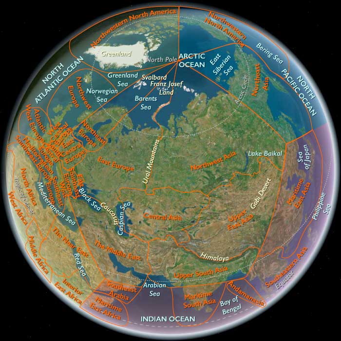
Northeastern Eurasia (1828–1971 CE)
From Tsarist Frontiers to Soviet Heartlands and Cold War Rimlands
Geography & Environmental Context
Northeastern Eurasia consists of three fixed subregions:
-
Northeast Asia — eastern Siberia (including Primorsky Krai), Sakhalin, the Chukchi Peninsula, Wrangel Island, Kuril Islands, and Hokkaidō (except its extreme southwest).
-
Northwest Asia — western and central Siberia from the Urals to roughly 130°E, including the West Siberian Plain, Altai, and the Central Siberian Plateau.
-
East Europe — the European portion of Russia, Belarus, and Ukraine, together with the Russian republics west of the Urals.
Anchors include the Arctic Ocean littoral (Kara, Laptev, and Okhotsk seas), the great river systems of the Ob–Irtysh, Yenisei, Lena, Amur–Ussuri, Dnieper, Don, and Volga, and the industrial–urban nodes of Leningrad (St. Petersburg), Moscow, Kyiv, Novosibirsk, Krasnoyarsk, Irkutsk, Vladivostok, and Sapporo. From tundra and taiga to loess plains and monsoon coasts, the region spans half the Northern Hemisphere’s climates and biomes.
Climate & Environmental Shifts
A sharply continental regime dominated interiors: long, frigid winters and short summers. The tail of the Little Ice Age persisted into the 19th century, then gave way to gradual warming, earlier river thaws, and glacier retreat in the Altai and Kamchatka by the mid-20th century. Periodic dzud winters devastated herds; drought pulses struck the Ukrainian steppe and Lower Volga (famines in the 1890s and early 1920s, and the Holodomor, 1932–33). In the Far East, typhoons and sea-ice shifts shaped fisheries; permafrost constrained construction across Siberia.
Subsistence & Settlement
-
Indigenous lifeways: Evenki, Nenets, Khanty, Chukchi, Koryak, Nivkh, Yupik, and Ainu sustained reindeer herding, sea-mammal hunting, fishing, trapping, and foraging—progressively curtailed by colonization, collectivization, and settlement policies.
-
Tsarist and Soviet expansion: Villages and penal settlements pushed east along the Trans-Siberian and river corridors; after 1917, collectivized agriculture and kolkhoz/sovkhoz systems reorganized the countryside of East Europe and southern Siberia.
-
Urbanization and industry: European Russia’s cities ( Moscow, Leningrad, Kyiv, Kharkiv, Donbas ) became heavy-industry cores; Siberia’s hubs ( Novosibirsk, Kemerovo, Krasnoyarsk, Irkutsk ) rose on coal, metals, and hydro, while Vladivostok, Khabarovsk, and Sapporo anchored the Pacific rim.
Technology & Material Culture
Railways (Trans-Siberian, 1891–1916; later Turk-Sib, branch lines) integrated steppe, taiga, and ports. Hydropower (e.g., Krasnoyarsk and Bratsk dams) and mining complexes transformed landscapes. In East Europe, steel, machine-building, and chemicals defined mass industrialization; in Northeast Asia, shipyards, ports, and fisheries expanded, while Hokkaidō underwent Meiji-to-postwar colonization and industrial growth. Everyday material culture shifted from log izbas and yurts to khrushchyovka apartments; radios, then TVs, entered homes by the 1960s.
Movement & Interaction Corridors
-
River highways: Seasonal shipping on the Ob, Yenisei, Lena, and Amur pre-dated and then fed rail hubs.
-
Trans-continental rails: Funneled grain, coal, ore, and people between European Russia and the Pacific; wartime evacuations (1941–42) relocated factories east.
-
Maritime arcs: The Okhotsk and Japan seas, Sakhalin–Hokkaidō–Kurils chain, and the Northern Sea Route(seasonal) tied fisheries, timber, and defense installations into Pacific networks.
-
Forced mobility: Tsarist exile and the Soviet Gulag (Kolyma, Norilsk, Vorkuta) drove coerced resettlement and resource extraction at massive human cost.
Cultural & Symbolic Expressions
Orthodox Christianity, Islam (in the Volga–Ural and North Caucasus margins of East Europe), Buddhism (Buryat and Mongol spheres), shamanic traditions, and—on Hokkaidō—suppressed Ainu culture framed identity against the rise of secular ideologies. Russian literature, music, and film radiated from Moscow and Leningrad; Soviet monumentalism and avant-gardes coexisted uneasily. Indigenous carving, song, and festival cycles persisted in Siberia and the Arctic, often underground, reviving visibly in the later 20th century.
Environmental Adaptation & Resilience
-
Permafrost engineering (pile foundations, winter roads) and taiga architecture enabled Siberian settlement.
-
Pastoral strategies: Herd diversification and seasonal migrations buffered dzud risk; state reindeer farms mixed traditional practice with planned quotas.
-
Agrarian adaptations: Shelterbelts, canals, and later the Virgin Lands campaigns extended cereal belts—often with soil erosion and dust storms by the 1960s.
-
Conservation beginnings: Zapovednik nature reserves (from 1916) protected representative biomes, even as industrial pollution rose in the Donbas, Upper Volga, and Kuzbass.
Political & Military Shocks
-
Tsarist consolidation and reform: The Emancipation of the Serfs (1861); Siberian penal colonization; the founding of Vladivostok (1860); Sakhalin as penal colony.
-
Revolution and Civil War (1917–22): Collapse of empire; shifting fronts across East Europe; creation of the USSR (1922).
-
Collectivization and terror: The Holodomor (1932–33) in Ukraine; purges; mass deportations to the Gulag and internal exiles in Siberia and the Far North.
-
Russo-Japanese War (1904–05) and Sakhalin/Kurils disputes; Hokkaidō settler colonialism and Ainu dispossession.
-
World War II: The Eastern Front ( Moscow, Stalingrad, Kursk, Leningrad ); devastation and liberation; Soviet seizure of southern Sakhalin and the Kurils (1945).
-
Cold War: East Europe as Soviet core; Northeast Asia militarized on both sides—the Pacific Fleet at Vladivostok; closed cities; the DEW Line/radar arcs in the Arctic; border incidents along the Amur by the late 1960s.
Transition
Between 1828 and 1971, Northeastern Eurasia was remade from a mosaic of imperial frontiers and Indigenous homelands into the industrial heartlands and strategic rimlands of two modern states: the USSR and Japan. Railways, mines, and dams bound taiga and tundra to Moscow; Hokkaidō’s Meiji-to-postwar transformation integrated it into Japan’s national economy. The costs were immense—famines, repression, deportations, cultural suppression—yet the region also generated vast material output and scientific achievement. By 1971, Northeastern Eurasia stood as a Cold War fulcrum: East Europe anchoring Soviet power, Northwest Asia supplying raw materials and hydro-electricity, and Northeast Asia bristling with fleets, airbases, and fisheries—its peoples negotiating survival and renewal between permafrost, ports, and power blocs.
Northeast Asia (1828–1971 CE): Tsarist Frontiers, Imperial Japan, and Cold War Divisions
Geography & Environmental Context
Northeast Asia includes eastern Siberia (east of 130°E, including Primorsky Krai and Sakhalin), northeastern Heilongjiang in China, the Chukchi Peninsula, Wrangel Island, and Hokkaidō (except its extreme southwest). Anchors include the Amur and Ussuri river basins, the Sea of Okhotsk, the Kamchatka Peninsula, and the Kuril Islands. The region combines Arctic tundra, boreal taiga, volcanic arcs, and rich marine coasts.
Climate & Environmental Shifts
A sharply continental climate defined the region: long winters, permafrost, and short summers. Droughts and harsh freezes (dzud) devastated herds in Siberian and Amur zones. Volcanic eruptions on Kamchatka and earthquakes in Sakhalin and Hokkaidō periodically destroyed settlements. Sea ice patterns shaped fishing and navigation. After 1945, industrialization and nuclear testing added new ecological pressures.
Subsistence & Settlement
-
Indigenous lifeways: Chukchi, Even, Koryak, and Nivkh peoples herded reindeer, hunted seals and whales, fished rivers, and gathered wild plants.
-
Russian settlement: From the mid-19th century, Tsarist Russia expanded along the Amur and into Primorsky Krai, founding Vladivostok (1860). Sakhalin became a penal colony.
-
Japanese settlement: Hokkaidō was colonized intensively after 1869, displacing Ainu through farming, fishing, and mining.
-
20th century: Soviet collectivization transformed Siberian villages; reindeer herding was reorganized into state farms. Postwar, Vladivostok, Khabarovsk, and Magadan became industrial hubs; Norilsk and Kolyma further west relied on forced labor.
Technology & Material Culture
-
Transport: River steamers plied the Amur; the Trans-Siberian Railway (1891–1916) tied Vladivostok to Moscow. Japan built railroads and ports in Hokkaidō. Postwar, Soviet highways, airfields, and gulag transport routes extended deep into the taiga.
-
Industry: Fishing, fur trade, timber, coal (Sakhalin), and later oil and military industries dominated. Hokkaidō developed mining, steel, and agriculture.
-
Everyday life: Yurts and wooden huts persisted in Siberia, while Soviet apartments (khrushchyovki) and Japanese wooden houses spread in urbanizing zones. Radios, sewing machines, and later TVs entered households after 1945.
Movement & Interaction Corridors
-
Tsarist conquest: Treaties of Aigun (1858) and Peking (1860) gave Russia the Amur–Ussuri territories.
-
Japanese expansion: Hokkaidō fully colonized; Sakhalin and the Kurils contested in Russo-Japanese War (1904–05).
-
Labor & exile: Penal labor on Sakhalin; Soviet deportations and gulags (Kolyma) forced millions east.
-
Military corridors: WWII saw Japanese control of southern Sakhalin and Kurils; Soviets seized them in 1945. Cold War militarization followed.
Cultural & Symbolic Expressions
-
Indigenous traditions: Shamanic ceremonies, reindeer festivals, and whale rituals persisted under suppression.
-
Colonial suppression: Ainu were displaced and assimilated in Japan; Nivkh and Chukchi were collectivized in USSR.
-
Literature: Accounts of exile (Chekhov on Sakhalin, 1890), gulag memoirs, and Japanese colonial writings depicted the region as harsh frontier.
-
Identity: Soviet patriotism celebrated Far Eastern development; Japan romanticized Hokkaidō as a northern frontier.
Environmental Adaptation & Resilience
-
Nomadic strategies: Reindeer herding diversified herds across tundra and taiga.
-
Fishing adaptation: Salmon runs sustained both Indigenous and settler economies; Soviet trawlers industrialized fisheries.
-
Cold adaptation: Fur clothing, log cabins, and later insulated housing ensured survival.
-
Modern pressures: Mining, deforestation, and gulag projects scarred landscapes but also supported settlement.
Political & Military Shocks
-
Russian empire: Secured Amur and Primorye in mid-19th century; Sakhalin developed as penal colony.
-
Russo-Japanese War (1904–05): Japan seized southern Sakhalin and challenged Russian Pacific presence.
-
World War II: Soviet offensives in 1945 seized Kurils and southern Sakhalin; Indigenous and Japanese civilians displaced.
-
Cold War: Vladivostok became closed Soviet naval base; Kurils remained disputed. Hokkaidō developed rapidly within U.S.-allied Japan, hosting defense installations.
-
Repression: Soviet collectivization, gulag labor, and forced sedentarization of nomads; Japanese assimilation of Ainu.
Transition
From 1828 to 1971, Northeast Asia transformed from Indigenous homelands and penal colonies into a militarized frontier of empires and Cold War blocs. Tsarist Russia absorbed Amur and Primorye, while Japan colonized Hokkaidō and contested Sakhalin and Kurils. WWII and Soviet offensives redrew borders, displacing populations. Collectivization, gulags, and industrialization under the USSR, and modernization in Hokkaidō under Japan, altered lifeways profoundly. By 1971, Northeast Asia was a land of naval bases, mines, fisheries, and Cold War garrisons, where Indigenous cultures persisted in fragments beneath the weight of empire and modern state power.
East Asia (1828–1971 CE)
Empires Unraveled, Revolutions Forged, and Economic Miracles Begun
Geography & Environmental Context
East Asia encompasses the great continental and insular arc from the Tibetan Plateau to the Pacific—two subregions held constant in this framework:
-
Upper East Asia: Mongolia and western China (Tibet, Xinjiang, Qinghai, Gansu, Ningxia, and adjoining uplands).
-
Lower East Asia: eastern and southern China, Taiwan, the Korean Peninsula, Japan, and the Ryukyu and Izu island chains.
The region spans deserts, plateaus, and alpine basins in the interior to humid river plains and monsoon coasts in the east. Its great rivers—the Yellow, Yangtze, and Pearl—linked agricultural cores to seaports that became gateways of both commerce and foreign control.
Climate & Environmental Shifts
Monsoon cycles continued to shape harvests. The 19th century saw floods, droughts, and famine in China (notably the North China Famine, 1876–79). Deforestation and siltation worsened flood damage in the Yellow River basin. The 20th century brought dam projects, terracing, and reforestation but also wartime devastation and later industrial pollution. Typhoons and earthquakes periodically struck Japan, Taiwan, and coastal China.
Subsistence & Settlement
-
Rural continuity: Rice, wheat, and millet remained staples; peasants formed the majority until mid-century land reforms.
-
Urban growth: Treaty ports (Shanghai, Tianjin, Yokohama, Nagasaki) became colonial enclaves; later, modern metropolises—Tokyo, Osaka, Seoul, Shanghai, Beijing—drove industrialization.
-
Migration: Millions moved within and beyond China as laborers and merchants; Mongolian and Tibetan pastoralists faced sedentarization under imperial and later socialist regimes.
Technology & Material Culture
Western industrial technology entered through ports and reforms. Railways, telegraphs, and steam navigation spread from the 1870s. After 1945, mechanization, electrification, and mass production reshaped daily life. Traditional crafts—porcelain, silk, lacquer, calligraphy—remained cultural touchstones even amid industrial growth. In the interior, Buddhist monasteries and nomadic tents coexisted with new socialist collectives and mines.
Movement & Interaction Corridors
-
Continental routes: Trans-Siberian and Chinese trunk railways integrated the interior.
-
Maritime networks: The Pacific and South China Sea tied treaty ports to global trade.
-
Diasporas: Chinese merchants, Korean and Japanese migrants, and Tibetan traders extended East Asian networks across Asia and beyond.
-
Military corridors: Repeated wars—the Opium Wars, Sino-Japanese conflicts, Pacific War, and Korean War—turned transport arteries into front lines.
Cultural & Symbolic Expressions
Confucian and Buddhist traditions persisted but were challenged by Christianity, socialism, and nationalism. The Meiji Restoration (1868) in Japan redefined tradition as modernization; Chinese reformers sought to “self-strengthen” through Western science; Mongolian and Tibetan Buddhism adapted to socialist oversight. Literature and art blended realism and modernism: Lu Xun in China, Tanizaki and Kawabata in Japan, Kim Sowol in Korea. Folk and classical forms—from Chinese opera to Japanese kabuki—remained central to identity.
Environmental Adaptation & Resilience
Irrigation and terracing stabilized yields; community granaries and kinship networks mitigated famine. After mid-century, land reform and collectivization in China, North Korea, and Mongolia transformed agrarian systems. Japan’s and South Korea’s reforestation and flood-control programs paralleled rapid industrial pollution control efforts by the late 1960s.
Political & Military Shocks
-
China: Opium Wars (1839–60) opened treaty ports; the Taiping (1850–64) and Boxer (1899–1901) uprisings shattered Qing control. The 1911 Revolution ended dynastic rule; the People’s Republic (1949) followed decades of warlordism, invasion, and civil war.
-
Japan: The Meiji state (1868) industrialized, defeated China (1894–95) and Russia (1904–05), built an empire, and after WWII reconstruction became an economic power.
-
Korea: From late-19th-century reforms through Japanese annexation (1910–45) to division after liberation and the Korean War (1950–53).
-
Mongolia: Gained independence from Qing (1911), became a Soviet-aligned republic (1924).
-
Tibet & Xinjiang: Integrated into the PRC (1950s) through force and reform; revolts in Tibet (1959) and Xinjiang repression marked ongoing contestation.
-
Cold War: East Asia was divided—communist mainland versus capitalist maritime rim—anchoring the global bipolar order.
Transition
Between 1828 and 1971, East Asia was remade through revolution, industrialization, and ideological division. Dynastic empires gave way to republics, colonies to nation-states. Japan and the “Little Tigers” entered early economic miracles; China and its interior pursued socialist transformation; Korea remained split; Mongolia and Tibet navigated life within Soviet and Chinese spheres. Across the region, modernization carried the weight of memory—Confucian ethics, Buddhist cosmology, and ancestral landscapes enduring beneath steel, slogans, and neon.
Maritime East Asia (1828–1971 CE): Dynastic Collapse, Imperial Encounters, and Industrial Revolutions
Geography & Environmental Context
Maritime East Asia encompasses southern and eastern China (Yunnan, Guangxi, Guizhou, Sichuan Basin, Chongqing, Hunan, Hubei, Henan, Shanxi, Hebei, Beijing, Guangdong, Fujian, Zhejiang, Jiangsu, Shandong, Liaoning, Jilin, southern Heilongjiang), Taiwan, the Korean Peninsula, southern Primorsky Krai, and the Japanese islands of Kyushu, Shikoku, Honshu, and southwestern Hokkaidō, plus the Ryukyu and Izu island chains. Anchors include the Yangtze and Yellow River basins, the Sichuan Basin, the Pearl River Delta, the Korean mountains and Han River valley, and the Japanese archipelago stretching into the Pacific.
Climate & Environmental Shifts
The subregion’s monsoonal regime brought alternating floods and droughts. China’s Yellow River repeatedly shifted course (notably floods of 1855, 1931), devastating farmlands. Famines struck northern China and Korea in the 19th century; deforestation in uplands worsened soil erosion. Typhoons regularly battered Taiwan, Fujian, and the Ryukyu chain. Industrial urbanization in Japan, Korea, and later coastal China introduced pollution and new ecological strains by the mid-20th century.
Subsistence & Settlement
-
China: Rice dominated the south (Yangtze, Pearl deltas); wheat, millet, and sorghum fed the north. Tea, silk, and cotton underpinned commerce. Urban hubs like Beijing, Shanghai, Guangzhou, Wuhan, and Chongqing grew rapidly.
-
Korea: Rice paddies in the south, millet and barley in the north; fishing villages dotted the coasts. Seoul (Hanyang) expanded modestly until the late 19th century, then became a colonial capital under Japan.
-
Japan: Rice agriculture was the base, but from the Meiji era (1868), industrialization transformed Osaka, Tokyo, and Yokohama into manufacturing and commercial centers.
-
Taiwan: Rice and sugar cultivation thrived; under Japanese colonial rule (1895–1945), plantations and infrastructure expanded.
-
Primorsky Krai: Fishing, forestry, and Russian settler agriculture integrated this fringe into both East Asian and Siberian networks.
Technology & Material Culture
-
19th century China: Weaving, porcelain, and handicrafts persisted; steamships, telegraphs, and railways entered through treaty ports.
-
Japan: The Meiji era imported Western technology; shipyards, railways, and modern factories reshaped cities. Postwar, Japan pioneered electronics and automobiles.
-
Korea: Under Japanese rule (1910–1945), railways, mines, and ports were developed; after 1945, the peninsula divided—North Korea industrialized under Soviet aid; South Korea struggled with war but began post-1960s export-driven growth.
-
Taiwan: Railways, irrigation, and port works under Japan; post-1949 Nationalist rule built industry with American support.
Movement & Interaction Corridors
-
Maritime hubs: Shanghai, Guangzhou, Nagasaki, and Busan tied the region into global shipping.
-
Railroads: Transcontinental Russian lines reached Primorsky; Japan built dense domestic networks; China’s first railways (1870s onward) expanded in treaty-port regions.
-
Migration: Millions of Chinese emigrated to Southeast Asia and the Americas; Japanese settlers moved into Korea and Taiwan under empire.
-
War corridors: From the Opium Wars (1839–42) to the Sino-Japanese War (1894–95), Russo-Japanese War (1904–05), Pacific War (1941–45), and the Korean War (1950–53), armies moved repeatedly across the subregion.
Cultural & Symbolic Expressions
-
China: The late Qing saw the Taiping and Boxer upheavals; Confucian traditions contended with Christian missions and modern reform. Republican-era intellectuals (May Fourth Movement, 1919) fostered new literature and nationalism.
-
Japan: The Meiji Restoration cultivated Shinto nationalism and Western-style arts; post-1945, pacifist democracy blended tradition with global modernism.
-
Korea: Confucian yangban culture dominated until colonization; Korean nationalism and literature grew under Japanese censorship; division after 1945 entrenched contrasting socialist and capitalist cultures.
-
Taiwan: Indigenous Austronesian traditions persisted alongside Chinese settler practices; Japanese colonial architecture and education left a lasting imprint.
-
Pan-Asian encounters: Buddhism, Confucianism, Shinto, Christianity, and modern ideologies all competed for influence.
Environmental Adaptation & Resilience
-
Flood control: Dikes and canals in China remained vital; 20th-century hydropower projects (Three Gorges precursors, 1950s–60s) began reshaping rivers.
-
Agrarian diversification: Potatoes, maize, and sweet potatoes spread, buffering famine in parts of China and Korea.
-
Urban resilience: Post-1945 reconstruction rebuilt Tokyo, Seoul, and Shanghai after wartime devastation.
-
Industrial adaptation: Japan rebuilt rapidly after 1945 into an export powerhouse, while China’s collectivization and Great Leap Forward (1958–62) caused famine but later stabilized under gradual reforms.
Political & Military Shocks
-
China:
-
Opium Wars (1839–42, 1856–60) opened treaty ports.
-
Taiping (1850–64) and Boxer (1899–1901) Rebellions shook Qing rule.
-
Fall of Qing (1911), Republic of China, and civil war (1920s–1949).
-
PRC founded 1949; Great Leap Forward (1958–62) and Cultural Revolution (1966–76) disrupted society.
-
-
Japan:
-
Meiji Restoration (1868); rapid modernization and empire-building.
-
Wars with China (1894–95), Russia (1904–05), and WWII (1941–45).
-
Defeat in 1945; U.S. occupation (1945–52) imposed democratic reforms.
-
-
Korea:
-
Annexed by Japan (1910–45); liberation after WWII.
-
Division (1945) and Korean War (1950–53) entrenched North/South split.
-
-
Taiwan:
-
Japanese colony (1895–1945).
-
Became base of Republic of China (Kuomintang) after 1949.
-
-
Primorsky Krai: Incorporated into Russian Empire (mid-19th c.); fortified as Soviet Far Eastern frontier in the Cold War.
Transition
Between 1828 and 1971, Maritime East Asia moved from dynastic decline and semi-colonial pressures to industrial revolutions, world wars, and ideological division. Qing China collapsed into republican and then communist rule; Japan transformed into both an empire and then a postwar economic powerhouse; Korea endured colonization, liberation, and Cold War partition; Taiwan became the stronghold of the Kuomintang. By 1971, the subregion was a Cold War flashpoint—with China’s UN seat transferring to the PRC, Japan rising as a global economic power, and the Korean peninsula divided—yet also a region of cultural dynamism and resilience rooted in centuries-old agrarian and urban traditions.
Central Asia (1828–1971 CE): Khanates to Republics: Rails, Cotton, and the Soviet Steppe
Geography & Environmental Context
Central Asia spans the Kazakh steppe (to the Irtysh and Altai forelands), the Karakum and Kyzylkum deserts, and the irrigated oases of the Amu Darya and Syr Darya—notably Bukhara, Samarkand, Khiva, and the Ferghana Valley—along with the Tian Shan–Pamir–Alay ranges and the Caspian east littoral. Anchors include the Aral Sea, Ustyurt Plateau, and passes to Kashgar and Badakhshan. This is a gradient from steppe grasslands to desert basins and snow-fed river oases.
Climate & Environmental Shifts
A continental climate brought droughts and harsh winters. The 19th century saw periodic dzud (ice-crust winters) killing herds; the 20th century added irrigation expansion that shrank the Aral Sea. Dust storms and salinization increased as cotton acreage rose. Mountain glaciers fed oases but were vulnerable to warming and overuse downstream.
Subsistence & Settlement
-
Steppe (Kazakh zhuzes): Transhumant herding of horses, sheep, camels; seasonal camps became kolkhoz/sovkhoz centers under Soviet rule.
-
Oases (Bukhara, Khiva, Samarkand, Ferghana): Wheat, melons, fruit, and especially cotton; bazaars and madrasas structured urban life.
-
Deserts: Karakum and Kyzylkum supported caravan wells and later pipelines and rail.
-
Soviet transformation: Collectivization (1930s) and virgin-lands plowing (1950s) altered settlement; towns like Tashkent, Almaty, Frunze (Bishkek), Dushanbe industrialized.
Technology & Material Culture
-
Rails & roads: The Trans-Caspian Railway (1880s) and later Turkestan–Siberian line integrated oases with Russia; postwar highways and airfields linked republics.
-
Irrigation: Canals (e.g., Great Fergana Canal, 1939) and later the Karakum Canal (1954–1988) massively expanded cotton; pumps, dams, and weirs transformed river regimes.
-
Industry: Textile mills, machine plants, mining (coal, copper, uranium), and oil/gas in western deserts burgeoned.
-
Everyday life: Yurts gave way to brick houses and Soviet apartments; bazaars coexisted with state shops; radios and cinemas spread socialist culture.
Movement & Interaction Corridors
-
Caravan to rail: Old Silk Road paths gave way to rail freight and troop trains; cotton and grain moved north, machinery south.
-
Migration: Tsarist settlement (Russians, Ukrainians, Volga Germans) into steppe; Soviet deportations and wartime evacuations reshaped demography. Virgin Lands recruited millions; oases drew rural labor into industry.
-
Cross-border linkages: Trade and cultural ties with Xinjiang persisted, though tightly controlled after 1949.
Cultural & Symbolic Expressions
-
Islamic learning: Bukhara and Samarkand’s madrasas persisted under repression; Sufi orders survived underground.
-
National formations: Jadid reformers (late 19th–early 20th c.) promoted modern education; the USSR carved Uzbek, Kazakh, Kyrgyz, Tajik, Turkmen republics with codified languages and folklore.
-
Arts: Persianate poetry, Turkic epics, and crafts endured; Soviet theaters and writers (Auezov, Abdulla Qahhor) merged national motifs with socialist realism.
-
Identity politics: Veiling campaigns (hujum), literacy drives, and korenizatsiya (indigenization) recast gender and ethnicity.
Environmental Adaptation & Resilience
-
Pastoral strategies: Herd diversification and winter shelters mitigated dzud; collectivization reduced flexibility.
-
Irrigation risks: Salinization, waterlogging, and Aral desiccation undermined long-term resilience; cotton monoculture made food supplies dependent on imports.
-
Hazard management: Soviet dams moderated floods but displaced communities; steppe shelterbelts fought wind erosion.
Political & Military Shocks
-
Tsarist conquest (1860s–1880s): Khanates subdued; protectorates established.
-
Revolution & Civil War: Basmachi resistance in the 1920s; Red Army consolidation created Soviet republics.
-
Collectivization & purges: Repression, famine, and deportations reshaped society.
-
World War II: Factories evacuated to Tashkent and Alma-Ata; Central Asia as rear base and troop supplier.
-
Postwar: Nuclear tests at Semipalatinsk; space launch support from Tyuratam/Baikonur (Kazakh steppe).
Transition
Between 1828 and 1971, Central Asia traversed a path from khanates and caravan oases to Soviet republics anchored by cotton, rails, and industry. The steppe’s herds were regimented; oases were dammed and piped; cities became hubs of science and production. Yet environmental costs—Aral Sea shrinkage, salinized fields, and dust storms—mounted, while cultural life balanced Islamic memory with Soviet nation-building. By 1971, Central Asia stood as a crucial Soviet hinterland and testing ground, its rivers and deserts harnessed to the ambitions of an industrial superpower.
Northwest Asia (1828–1971 CE): Tsarist Siberia, Soviet Industrial Heartlands, and the Cold War Frontier
Geography & Environmental Context
Northwest Asia stretches from the Ural Mountains eastward to roughly 130°E, covering western and central Siberia. Anchors include the West Siberian Plain, the Ob, Irtysh, Yenisei, and Lena rivers (upper and middle reaches), the Altai Mountains, the Central Siberian Plateau, and tundra–taiga belts reaching to the Kara and Laptev Seas. Cities such as Omsk, Novosibirsk, Tomsk, Krasnoyarsk, Tobolsk, and Irkutsk grew along river and rail corridors, tying the vast interior to European Russia and the Pacific.
Climate & Environmental Shifts
A sharply continental climate defined the region: long, frigid winters and short, hot summers. The 19th century brought repeated crop failures and famines in steppe margins. Seasonal flooding of the Ob and Yenisei disrupted transport but enriched floodplain soils. In the Soviet era, industrial expansion scarred landscapes—open-pit mines, hydroelectric dams, and deforestation transformed ecologies. The Virgin Lands Campaign (1950s–60s) expanded cultivation into steppe margins of Kazakhstan and southern Siberia, initially boosting output but leading to erosion and dust storms by the 1960s.
Subsistence & Settlement
-
Indigenous lifeways: Evenki, Nenets, Khanty, and other groups continued reindeer herding, hunting, fishing, and trapping, though often disrupted by Russian expansion and Soviet collectivization.
-
Russian settlers: Peasant colonization deepened in the 19th century, with rye, oats, wheat, and potatoes planted in the southern taiga and steppe.
-
Urban growth: Towns like Novosibirsk (founded 1893 as a Trans-Siberian rail hub) and Krasnoyarsk expanded into industrial centers. Tomsk and Irkutsk became cultural and administrative hubs.
-
20th-century collectivization: Peasant farms reorganized into kolkhozes and sovkhozes; livestock and grain production scaled up.
Technology & Material Culture
-
Transport: The Trans-Siberian Railway (1891–1916) revolutionized settlement, linking Siberia to Moscow and Vladivostok. Branch lines tied Omsk, Novosibirsk, and Irkutsk to mining basins. In Soviet times, highways, airfields, and river fleets augmented movement.
-
Industry: Coal from the Kuznetsk Basin, gold in the Lena fields, iron in the Urals, and oil in western Siberia transformed the economy. After 1945, the Novosibirsk Academgorodok became a symbol of Soviet science cities.
-
Everyday life: Wooden izbas remained common in villages, while Soviet apartment blocks (khrushchyovki) reshaped urban living. Radios, bicycles, and sewing machines proliferated by mid-century; televisions and automobiles appeared in the 1960s.
Movement & Interaction Corridors
-
River routes: The Ob and Yenisei remained seasonal highways, vital before full rail expansion.
-
Rail networks: The Trans-Siberian became the backbone of migration and grain exports; later, the Turkestan–Siberian and Baikal–Amur lines extended reach.
-
Exile and forced labor: Tsarist Russia sent dissidents and convicts east; the Soviet Gulag system (Kolyma, Norilsk, Krasnoyarsk camps) made Siberia synonymous with forced labor and resource extraction.
-
Migration flows: Voluntary settlers (peasants, workers, engineers) moved eastward; after WWII, displaced persons and war prisoners were relocated here.
Cultural & Symbolic Expressions
-
Orthodoxy: Russian settlers built churches, integrating Siberia into the religious sphere of the empire. Soviet atheism later suppressed open practice.
-
Indigenous traditions: Shamanic rites, oral epics, and seasonal festivals endured underground, even as collectivization curtailed mobility.
-
Literature & identity: Siberia became both exile and frontier—memorialized in works by Dostoevsky (earlier) and later Soviet novels about pioneers and labor heroes.
-
Science & education: Tomsk University (founded 1878) and Novosibirsk Academgorodok (1957) embodied Siberia’s symbolic role as a scientific frontier.
Environmental Adaptation & Resilience
-
Indigenous strategies: Nomadic herding, fishing, and hunting persisted where possible, though squeezed by settlement and industrialization.
-
Peasant resilience: Mixed farming with rye, potatoes, and livestock buffered harsh winters.
-
Soviet megaprojects: Hydroelectric dams (e.g., Krasnoyarsk, Bratsk), collective farms, and resource extraction provided food and power but disrupted ecologies and displaced communities.
-
Cold adaptation: Fur clothing, log housing, and later centralized heating and insulated Soviet blocks enabled settlement across the taiga and tundra.
Political & Military Shocks
-
1828–1917 (Tsarist era): Siberia served as penal colony and frontier for Russian expansion; the Trans-Siberian tightened control.
-
1917–22 (Revolution & Civil War): Siberia was contested by White and Red armies; Allied troops landed in Vladivostok, and Czech Legion forces crossed the Trans-Siberian.
-
Stalinist period: Collectivization, Gulag expansion, and deportations (e.g., Volga Germans, Chechens, Crimean Tatars) remade demographics. Industrialization in Kuzbass and Norilsk turned Siberia into a resource base.
-
World War II: Factories evacuated from European Russia relocated to the Urals and West Siberia, fueling the Soviet war machine.
-
Cold War (1945–1971): Siberia became a strategic depth zone—hosting nuclear test sites, missile silos, and secret science cities. Novosibirsk and Tomsk symbolized Soviet progress; Norilsk and Magadan symbolized coercion.
Transition
From 1828 to 1971, Northwest Asia (Siberia west of 130°E) shifted from an imperial hinterland of exiles and fur traders into a core Soviet industrial frontier. Railroads, mining, and hydro dams bound the taiga and steppe into national networks. Indigenous lifeways eroded under settlement and collectivization, while forced labor and resource megaprojects scarred landscapes. Yet new science cities and industries projected modernity. By 1971, Northwest Asia embodied the Soviet paradox: a land of hardship, coercion, and ecological strain—yet also the keystone of industrial might and Cold War power.
East Europe (1828–1971 CE): Tsarist Expansion, Socialist Transformation, and Cold War Frontiers
Geography & Environmental Context
East Europe includes Belarus, Ukraine, the European portion of Russia, and the sixteen Russian republics west of the Urals. Anchors span the Baltic–Black Sea watershed, the Dnieper, Don, and Volga basins, the Carpathian fringe in western Ukraine, and the vast Russian Plain stretching toward the Urals. Major cities include Moscow, Leningrad (St. Petersburg), Kyiv, Minsk, Smolensk, Kharkiv, Odessa, and Novgorod.
Climate & Environmental Shifts
A continental climate produced harsh winters and hot summers. Crop failures punctuated the 19th century (famines in 1840s, 1891–92). Deforestation and soil exhaustion pressed peasants; steppe droughts recurred, notably in the 1920s and 1940s. The Virgin Lands campaign (1950s) extended cultivation into steppe margins, often unsustainably. River control projects (Dnieper Hydroelectric Station, Volga–Don Canal) and massive reforestation campaigns altered landscapes, while industrial pollution intensified after WWII.
Subsistence & Settlement
-
Agriculture: Wheat, rye, barley, oats, and later maize and sugar beet dominated. The black earth (chernozem) zone in Ukraine and southern Russia remained the empire’s and USSR’s breadbasket. Dairy, potatoes, and flax sustained Belarus and northern Russia.
-
Rural settlement: Villages of wooden cottages (izbas) under communal landholding (mir or obshchina) persisted until reforms. After collectivization (1930s), collective and state farms reorganized the countryside.
-
Urbanization: By the late 19th century, cities like Moscow, Kyiv, and Odessa swelled with factories. Soviet industrialization (1930s onward) created new cities in the Urals’ western fringe and magnified Donbas, Kharkiv, and Moscow. By the 1960s, Minsk, Kyiv, and Moscow were industrial and cultural hubs.
Technology & Material Culture
-
19th century: Railways (Moscow–St. Petersburg, Odessa–Kyiv) integrated markets. Peasants used iron plows, scythes, and horse-drawn wagons.
-
Industrialization: Steelworks in Donbas, textile mills in Moscow, machine building in Kharkiv, and shipyards in Odessa expanded. Hydroelectric stations on the Dnieper and Volga symbolized Soviet modernization.
-
Everyday life: Peasant households centered on icon corners, ovens, and handmade tools until collectivization introduced standardized housing. Soviet urban apartments, radios, and later televisions spread by mid-20th century.
Movement & Interaction Corridors
-
River highways: Dnieper and Volga carried grain, timber, and coal.
-
Railways: By the late 19th century, St. Petersburg–Warsaw, Kyiv–Moscow, and Odessa–Donbas lines integrated the empire.
-
Ports: Odessa and Sevastopol tied Ukraine to Black Sea trade. Murmansk and Leningrad were naval and commercial gates.
-
Migration: Serfs freed in 1861 moved to new lands; Soviet deportations and wartime evacuations displaced millions. After WWII, labor mobilization filled Siberian and Ural industries with migrants from Ukraine and Belarus.
Cultural & Symbolic Expressions
-
Religion: Orthodoxy remained central under tsars; Catholic enclaves persisted in Belarus and Ukraine; Judaism flourished in the Pale of Settlement until pogroms and emigration. Soviet atheism after 1917 repressed churches, though folk religiosity endured underground.
-
Literature & arts: 19th-century classics (Gogol, Tolstoy, Dostoevsky, Shevchenko) defined world literature. Soviet culture emphasized socialist realism (Gorky, Sholokhov, Ehrenburg). Ukrainian and Belarusian revivals flourished briefly in the 1920s before Stalinist repression.
-
Music & folklore: Russian ballets, Ukrainian folk songs, Belarusian epics, and Soviet mass songs coexisted. After 1945, film and radio disseminated propaganda alongside cultural achievements.
Environmental Adaptation & Resilience
-
Peasant strategies: Crop rotation, communal redistribution, and grain storage buffered famine but often failed under poor harvests.
-
Soviet collectivization: Mechanization, state seed reserves, and irrigation projects aimed at stability but caused dislocation and famine (notably Holodomor, 1932–33).
-
Postwar: Massive rebuilding campaigns restored cities and farms after Nazi devastation; dams and canals mitigated drought but caused salinization and ecological strain.
Political & Military Shocks
-
Tsarist reforms: Emancipation of serfs (1861); industrialization drives under Alexander III and Nicholas II.
-
Revolutions: 1905 unrest; 1917 February and October revolutions toppled tsarism and established Bolshevik rule.
-
Civil War (1918–21): Ukraine, Belarus, and western Russia ravaged by conflict and shifting borders.
-
Stalinist era: Collectivization, purges, forced deportations, famines, and rapid industrialization.
-
World War II: Nazi invasion (1941) devastated Belarus, Ukraine, and western Russia. Battles of Kyiv, Stalingrad, Kursk, and the siege of Leningrad defined the Eastern Front. Soviet victory in 1945 left East Europe under Moscow’s control.
-
Cold War: The subregion formed the USSR’s European core, with Moscow and Leningrad as global Cold War capitals. Eastern Europe beyond was drawn into Warsaw Pact (1955), cementing the frontier with NATO.
Transition
Between 1828 and 1971, East Europe was transformed from a Tsarist agrarian empire into the industrial, military, and political heartland of the Soviet Union. Grain surpluses, railways, and industrial cities arose in the 19th century; revolutions and civil war destroyed imperial order; collectivization, purges, and world war remade society. By the 1960s, Moscow, Kyiv, and Minsk were modern socialist cities, commanding an empire stretching from Berlin to the Urals. Yet the costs were immense—famine, repression, war, and environmental degradation—leaving a legacy of resilience shaped by both survival and control.
North Europe (1828–1971 CE)
Industrial Transformation, Welfare States, and the Balance Between Tradition and Modernity
Geography & Environmental Context
North Europe includes two fixed subregions:
-
Northeast Europe — Sweden, Finland, Lithuania, Latvia, Estonia, eastern Denmark, eastern Norway, and the Russian enclave of Kaliningrad.
-
Northwest Europe — Iceland, Ireland, the United Kingdom, western Norway, and western Denmark.
Anchors include the Baltic Sea, North Sea, and Norwegian Sea, the Scandinavian Mountains, and the North Atlantic islands. Major urban and cultural centers included Stockholm, Helsinki, Copenhagen, Oslo, Reykjavík, Dublin, Belfast, Edinburgh, Glasgow, and London. The subregion’s mix of fjords, forests, and fertile lowlands underpinned both agrarian heritage and maritime expansion.
Climate & Environmental Shifts
A temperate to subarctic climate defined the region. The 19th century brought short agricultural seasons and heavy reliance on fisheries and forestry. Industrial coal use caused early urban pollution in British and Scandinavian cities. The 20th century’s warming trend moderated winters, improving crop yields and extending growing zones in Scandinavia. Hydroelectric dams in Norway, Sweden, and Finland harnessed mountain rivers, while coastal engineering in the Netherlands and Denmark mitigated storm surges.
Subsistence & Settlement
-
Agrarian modernization: Land reforms and cooperative movements in Denmark, Sweden, and Finland raised productivity; dairy and timber industries grew.
-
Industrialization: Britain’s early Industrial Revolution spread to Scandinavia and the Baltics, with shipbuilding, textiles, steel, and engineering as core sectors.
-
Urbanization: By the early 20th century, London, Manchester, and Glasgow ranked among the world’s largest industrial cities; Stockholm, Copenhagen, and Oslo modernized with public housing and electrified transport.
-
Postwar economies: Reconstruction and social-democratic planning in the Nordic countries created prosperous welfare states; Britain transitioned from empire to post-industrial society.
-
Migration: Rural exodus to cities accelerated; Irish emigration to North America and Britain persisted; Baltic populations endured wartime deportations and Soviet resettlements.
Technology & Material Culture
Coal-fired industry, railways, and steam navigation defined the 19th century. British engineers exported rail technology worldwide. The 20th century saw electrification, radio, aviation, and shipbuilding innovation. Architecture evolved from Gothic revival and neoclassicism to functionalism and modernism—exemplified by Stockholm City Hall (1923)and London’s postwar reconstruction. Nordic design—Alvar Aalto, Arne Jacobsen—became globally influential for its simplicity and craftsmanship.
Movement & Interaction Corridors
-
Maritime trade: The North Sea and Baltic remained major arteries linking Britain, Scandinavia, and continental Europe. Liverpool, London, Bergen, and Copenhagen were vital Atlantic ports.
-
Rail and telegraph networks: Integrated interior trade by the 1870s; air corridors in the 20th century linked northern capitals to the world.
-
Colonial and global circuits: Britain’s imperial shipping routes spanned all oceans; Norwegian and Icelandic seafarers joined global fleets.
-
Wartime and Cold War lines: The region formed the northern flank of both world wars and later the NATO–Warsaw Pact divide.
Cultural & Symbolic Expressions
-
Romantic nationalism: Writers and artists—Hans Christian Andersen, Henrik Ibsen, Edvard Grieg, Akseli Gallen-Kallela—revived folklore and national epics.
-
Industrial and imperial culture: Britain’s Victorian Age merged empire, science, and literature—Charles Dickens, George Eliot, Alfred Tennyson, Charles Darwin reflected industrial modernity.
-
20th-century innovation: Modernist movements in design, architecture, and literature flourished in the Nordic world; British and Irish literature—from W. B. Yeats, James Joyce, and Virginia Woolf to Samuel Beckett—reshaped global modernism.
-
Religion and society: Protestantism remained dominant in Scandinavia and Britain; secularism and ecumenism grew by mid-century. Music—from Edward Elgar to Jean Sibelius—bridged nationalism and cosmopolitanism.
Environmental Adaptation & Resilience
Nordic societies pioneered cooperative forestry and sustainable fisheries. Hydroelectric and geothermal power (Iceland) reduced reliance on imported fuel. Welfare-state planning integrated housing, health, and environmental standards. Coastal flood control (e.g., the Delta Plan, Netherlands; Thyborøn Barrier, Denmark) and Arctic research expanded environmental awareness by the 1960s.
Political & Military Shocks
-
Reform and union changes: The Reform Acts in Britain broadened suffrage; Norway’s independence from Sweden (1905) redefined Nordic diplomacy.
-
World War I: Britain, Ireland, and the Nordic countries were affected by blockade and neutrality tensions; Ireland’s Easter Rising (1916) marked the drive for independence.
-
Interwar transformations: Ireland became a Free State (1922); Finland and the Baltics gained independence after the Russian Revolution.
-
World War II: Britain endured the Blitz; Norway and Denmark were occupied by Germany; Finland fought the USSR; Sweden remained neutral; Iceland hosted Allied bases.
-
Postwar reconstruction: Britain dismantled its empire; Scandinavia developed social democracy; Finland balanced between East and West.
-
Cold War alignments: Norway, Denmark, and Britain joined NATO (1949); Sweden and Finland remained neutral; the Baltics were annexed by the USSR.
Transition
Between 1828 and 1971, North Europe evolved from an industrial and maritime heartland of empire into a zone of social democracy, neutrality, and cultural innovation. Britain’s industrial dominance yielded to Nordic welfare models; Ireland and Finland secured independence; the Baltics lost theirs under Soviet rule. War, reconstruction, and integration produced some of the world’s highest living standards. By 1971, North Europe stood as both a bastion of stability and a frontier of modern design, environmental consciousness, and egalitarian governance—its fjords, harbors, and forests emblematic of resilience in a turbulent century.
Northeast Europe (1828–1971 CE): Nordic Neutralities, Baltic Nationhood, and a Sea of Corridors
Geography & Environmental Context
Northeast Europe includes Sweden, Finland, Lithuania, Latvia, Estonia, the Russian enclave of Kaliningrad, and eastern Denmark and eastern Norway (including Copenhagen and Oslo). Anchors span the Baltic Sea littoral—Stockholm’s skerries, the Åland and Estonian archipelagos, the Gulf of Finland and Bothnia, and the Vistula Lagoon/Kaliningrad—together with lake-and-forest interiors (Sweden’s Småland–Norrland, Finland’s Lakeland). Capitals Stockholm, Helsinki, Tallinn, Riga, Vilnius, Copenhagen, and Oslo formed a dense ring of maritime nodes.
Climate & Environmental Shifts
A cool temperate regime brought long winters and short, capricious summers. Crop crises struck periodically—the Finnish Great Famine (1866–68) was the worst—while forest and storm-fell events shaped upland livelihoods. Hydropowerable rivers in Sweden, Finland, and Norway enabled 20th-century electrification. By the late 1960s, Baltic eutrophication and industrial pollution emerged as regional stresses, even as afforestation and wildlife protections expanded.
Subsistence & Settlement
-
19th century countryside: Mixed farms (rye, oats, barley, potatoes) with dairy and forestry incomes; fishing (herring, Baltic cod) fed coasts.
-
Timber & tar to pulp & paper: Sweden and Finland shifted from sawn timber and tar exports to pulp, paper, and engineered wood, spawning mill towns along rivers.
-
Urbanization: Ports and capitals boomed—Stockholm, Helsinki, Copenhagen, Oslo—alongside Baltic hubs Tallinn, Riga, Vilnius; interwar conurbations spread around shipyards and rail junctions. Post-1945, new suburbs and modernist estates housed industrial workforces.
Technology & Material Culture
Railways bound forests to ports; icebreakers kept winter trade moving. Engineering clusters emerged: shipyards in Turku and Helsinki, Swedish steel and machine tools, optics and telecoms, and later vehicle and aircraft industries. Hydropower stations, district heating, and cooperative dairies transformed everyday life; by the 1960s, cars, radios, and televisions were commonplace from Stockholm to Tallinn.
Movement & Interaction Corridors
-
Baltic Sea highways: Ferries and freighters knit Stockholm–Turku–Helsinki, Tallinn–Riga–Klaipėda, and Copenhagen–Malmö; the Øresund remained the gate to the North Sea.
-
Resource flows: Ore and timber moved to Baltic smelters and mills; dairy and fish to urban markets.
-
War and peace lines: In WWII, sea lanes became battle zones; after 1945, NATO (Denmark, Norway), neutral Sweden, and Finland’s treaty constraints created tightly managed but busy frontiers with the Soviet sphere including the annexed Baltic republics.
Cultural & Symbolic Expressions
-
National awakenings: Kalevala publication (1835) in Finland; Song Festivals in Estonia and Latvia; Lithuania’s clandestine press during the press ban (1864–1904) and the knygnešiai (book-smugglers) forged modern identities.
-
Golden ages & modernisms: Sibelius and Nielsen in music; Strindberg, Hamsun, and Sillanpää in letters; Munch (Oslo) and Nordic functionalist architecture; Baltic avant-gardes in interwar Riga, Tallinn, and Kaunas.
-
Welfare imaginaries: Lutheran people’s movements and cooperative traditions fed into 20th-century Nordic welfare models, shaping education, health, and housing.
Environmental Adaptation & Resilience
-
Forestry regimes: Scientific silviculture, replanting, and state forests balanced sawmill demand; log-driving gave way to rail and truck transport.
-
Agrarian modernization: Land consolidation, dairying co-ops, and sugar-beet belts stabilized farm incomes; state grain stores buffered lean years.
-
Cold adaptation: Ice roads, heated district systems, and winterized housing normalized life at high latitudes.
Political & Military Shocks
-
1848–1905 reform wave: Constitutional and social reforms expanded suffrage (notably early in the Nordics) and strengthened parliaments.
-
Independence of the Baltic states (1918): Estonia, Latvia, Lithuania emerged from WWI; interwar authoritarian turns (Ulmanis, Smetona) followed economic shocks.
-
Winter War & Continuation War (1939–44): Finland fought the USSR, ceded Karelia, and resettled evacuees while retaining sovereignty.
-
Baltic occupations (1940, 1944): The three Baltic states were annexed by the USSR; deportations (1941, 1949)and Sovietization transformed society.
-
Denmark & Norway (1940–45): German occupation; resistance, sabotage, and postwar NATO alignment (1949). Sweden remained neutral, a humanitarian and industrial hub.
-
Cold War settlement: Finland’s YYA Treaty (1948) balanced Western trade with Soviet security demands; Nordic Council (1952) deepened regional cooperation; North Sea oil discovery (1969) began to reorient Norway’s economy.
Transition
Between 1828 and 1971, Northeast Europe traveled from rural timber and tar economies through industrialization, welfare-state construction, and Cold War partition. Sweden and the Nordic capitals built neutral or Western-aligned prosperity on forestry, hydropower, and engineering; Finland navigated survival between blocs; the Baltic states experienced independence, then Soviet annexation and profound coercion. By 1971, ferries, cables, and welfare institutions ringed the Baltic, even as an ideological frontier cut across its waters—setting the stage for détente, environmental cleanup, and, decades later, renewed Baltic sovereignty.
Central Europe (1828–1971 CE)
Revolutions, Empires’ Collapse, and Divided Modernities
Geography & Environmental Context
Central Europe includes three subregions:
-
East Central Europe — Germany east of 10°E, Czechia (Bohemia and Moravia), Slovakia, Poland, and Hungary.
-
West Central Europe — Germany west of 10°E, the Rhine-adjacent far northwest of Switzerland (Basel region), and parts of Luxembourg.
-
South Central Europe — western and southern Austria (except Salzburg), Liechtenstein, extreme southwestern Germany, and southeastern Switzerland, including Geneva and Zurich.
Anchors include the Rhine, Danube, and Elbe river systems; the Bohemian Massif, Alps, and Carpathian foothills; and the major cities of Berlin, Vienna, Munich, Warsaw, Budapest, Prague, Zurich, and Basel. The region’s continental climate favored cereals, vineyards, and industry, while its rivers and mountain passes made it Europe’s political and commercial hinge.
Climate & Environmental Shifts
Central Europe’s temperate climate supported intensive agriculture but was prone to seasonal floods and cold winters. Deforestation for coal and iron production expanded through the 19th century, giving way to reforestation and hydropower projects in the 20th. Industrial pollution grew around the Ruhr, Upper Silesia, and Vienna basins. After 1945, massive reconstruction and dam building (e.g., on the Danube and Rhine) reshaped river systems.
Subsistence & Settlement
-
Agrarian reform and industrialization: The 19th century brought enclosure of communal lands, railway expansion, and industrial zones in Saxony, Silesia, and Bohemia. Peasants became factory laborers; textile, iron, and machinery industries transformed cities like Lodz, Prague, and Leipzig.
-
Urban growth: Capitals such as Berlin, Vienna, and Budapest became imperial metropolises, centers of administration, culture, and intellectual life.
-
Postwar economies: After 1945, reconstruction divided trajectories: Western Germany and Switzerland pursued market economies, while Eastern bloc states collectivized agriculture and nationalized industries.
-
Migration: Millions of ethnic Germans, Poles, and Hungarians were displaced by wars and redrawn borders, particularly after World War II.
Technology & Material Culture
-
19th century innovations: Railways (Berlin–Vienna, Leipzig–Prague), telegraphs, and mechanized mills spread industrial modernity. Steelworks in Silesia and the Ruhr and engineering in Zurich and Vienna marked technological leadership.
-
20th century transformation: Electrification, automobiles (Volkswagen, Skoda), and modern architecture (Bauhaus, Werkbund) reshaped landscapes. Socialist-era prefabricated housing and Western modernist reconstruction reflected competing visions of progress.
-
Cultural industries: Printing, publishing, and music (Beethoven, Brahms, Dvořák, Liszt) gave the region global cultural authority that persisted into modern cinema and design.
Movement & Interaction Corridors
-
River routes: The Rhine–Danube corridor remained Europe’s main commercial artery.
-
Rail and road networks: Linked industrial centers to North Sea ports and Balkan markets.
-
Migration corridors: Seasonal labor moved from Poland and Galicia to Germany and Austria; postwar emigration carried intellectuals and refugees westward.
-
Air and Cold War lines: By mid-20th century, the Iron Curtain cut traditional corridors, dividing East Central Europe from West Germany, Austria, and Switzerland.
Cultural & Symbolic Expressions
Central Europe’s identity blended Enlightenment cosmopolitanism, nationalism, and later ideological rivalry.
-
Romantic nationalism: Poets and composers celebrated folk culture—Chopin, Smetana, Petőfi, Heine—fueling independence movements.
-
Modernism: The early 20th century produced Klimt, Kafka, Freud, and Schoenberg, whose works redefined art and thought.
-
Religious and philosophical diversity: Catholic, Protestant, and Jewish traditions coexisted, though the Holocaust annihilated much of Jewish life.
-
Postwar culture: Socialist realism dominated Eastern states, while Western zones embraced modernist abstraction and existentialism.
Environmental Adaptation & Resilience
Rural cooperatives, forest management, and Alpine water engineering stabilized agriculture and power. Urban reconstruction after WWII demanded massive planning and rebuilding; green belts and public transit shaped livable postwar cities. Pollution crises in mining basins spurred early environmental regulation by the 1960s.
Political & Military Shocks
-
Revolutions of 1848: Swept Vienna, Berlin, Budapest, and Prague; liberal constitutions and national aspirations briefly flourished before repression.
-
Unifications: The Austro-Hungarian Compromise (1867) created a dual monarchy; Germany unified under Prussia (1871).
-
World War I: Dissolved empires; Austria-Hungary and Germany collapsed; new states—Poland, Czechoslovakia, Yugoslavia, and Hungary—emerged.
-
Interwar fragility: Economic turmoil and fascist movements rose amid minority tensions.
-
World War II: Nazi expansion and genocide devastated the region; millions perished in camps such as Auschwitz, Theresienstadt, and Dachau.
-
Postwar division: Germany split into FRG and GDR; Eastern Europe entered the Soviet sphere. The Berlin Airlift (1948–49) and Hungarian Uprising (1956) symbolized Cold War polarization.
-
Reconstruction and détente: By the 1960s, West Germany’s “economic miracle” contrasted with Eastern stagnation; Prague Spring (1968) and its suppression revealed limits to reform.
Transition
Between 1828 and 1971, Central Europe transformed from a region of empires and revolutions into the symbolic heart of Europe’s ideological divide. Railways, factories, and universities forged modern society; wars and genocide shattered it; reconstruction and partition redefined it. The Rhine–Danube basin remained Europe’s industrial spine, while Vienna, Berlin, and Warsaw embodied its creative and political ferment. By 1971, Central Europe stood divided yet vital—where memory of empire, trauma of war, and promise of renewal continued to shape the continent’s future.