Polynesia
Related Events
Showing 10 events out of 295 total
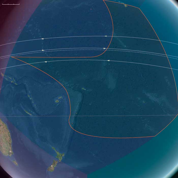
Northern Oceania encompasses Northeast Asia, North Polynesia, and Northwestern North America.
Its southeastern boundary extends from 48.1896851°N, approximately 75 miles south of the Alberta-Saskatchewan-Montana junction, to the Pacific Ocean at Cape Mendocino. To the immediate northwest of this line lies the Pacific Northwest.
In Canada, Alberta and British Columbia form the border with the United States, while to the north lie Nunavut, the Northwest Territories, Yukon, and Alaska.
The eastern boundary at 110°W was originally designated as the Fourth Meridian of the Dominion Land Survey. However, due to the limitations of early surveying techniques, the meridian was placed slightly west of this longitude. Since 1905, the Fourth Meridian has served as the entire boundary between Alberta and Saskatchewan and continues northward as the dividing line between Nunavut and the Northwest Territories above 70°N.
Northern Oceania's western boundary, at 130°E, roughly aligns with the division between Siberia and the Russian Far East, corresponding to Russia’s Siberian and Far Eastern federal districts. This boundary terminates above the Amur River, which has historically marked the border between Russia and China’s Heilongjiang province. The northernmost point of China, in Mohe City, lies along this river.
The southwestern boundary separates most of Japan’s northernmost major island, Hokkaido, from Honshu and the rest of the Japanese archipelago.
HistoryAtlas contains 401 entries for Northern Oceania from the Paleolithic period to 1899.
Narrow results by searching for a word or phrase or select from one or more of a dozen filters.
Polynesia (49,293 – 28,578 BCE): Upper Paleolithic I — Volcanic Arcs, Reef Foundations, and the Architecture of Isolation
Geographic & Environmental Context
During the later Pleistocene, the Polynesian sector of the Pacific was a scattered domain of volcanic peaks, emerging atolls, and widening reef flats—a geography still entirely devoid of humans but already constructing the natural architecture that would one day sustain them.
The region spanned three great arcs of islands:
-
The Hawaiian–Emperor chain in the north, including Oʻahu, Maui, Molokaʻi, Kauaʻi, Niʻihau, and Midway, where high volcanic forms dominated the subtropics.
-
The central–western archipelagos—Tonga, Samoa, the Cook and Society Islands, the Marquesas, Tuvalu, and Tokelau—a mixture of high volcanic islands, raised limestone platforms, and embryonic atolls.
-
The eastern fringe—future Pitcairn and Rapa Nui—where lone volcanic edifices rose from deep ocean basins, linked only by the great South Pacific gyres and currents.
Sea level stood ~100 m lower than today, exposing vast coastal benches and broad shelves around high islands. Many modern lagoons lay dry, their reef rims fossilized in the air; others built episodically with interglacial warm phases. Across the region, reef, volcano, and ocean interacted in long cycles of uplift and subsidence—the slow choreography that would, over tens of millennia, produce the Polynesian Triangle’s intricate geography.
Climate & Environmental Shifts
The epoch was framed by full glacial conditions—cooler sea-surface temperatures, stronger trade winds, and a sharply defined dry season.
-
Atmosphere and Ocean: Strengthened trades drove upwelling along many leeward coasts, favoring cool, nutrient-rich nearshore waters. Seasonal dust episodes and winter surf reworked coastal benches, while the intertropical convergence zone (ITCZ) oscillated northward and southward with orbital rhythms.
-
Late-Glacial Variability: Even within the long glacial, brief mild interstadials brought short-lived reef growth spurts and pulses of vegetation recovery. Cooler phases depressed the coral-algal community but expanded coastal steppe and dry scrub.
-
Volcanic Activity: Continuous effusive volcanism in the Hawaiian Big Island and intermittent eruptions in the Societies, Marquesas, and Cooks rejuvenated landscapes, built fresh lava plains, and created ephemeral crater lakes and ash-fed soils.
Overall, Polynesia’s climate oscillated between cool, windy glacial stability and short warming pulses that allowed the reef crest and forest line to advance and retreat in rhythm with the global climate.
Biota & Baseline Ecology (No Human Presence)
Every island was its own closed laboratory of evolution.
-
Marine Life:
Coral communities fluctuated with sea level and temperature, but even under glacial suppression, shallow fringing reefs persisted. Fish, mollusk, turtle, and seabird populations were immense, their only predators sharks and seals. On outer banks like Midway, Tokelau, and Tuvalu, monk seals and turtles bred in numbers far exceeding modern densities. -
Terrestrial Life:
The higher islands—Hawaiʻi, Tahiti, Samoa, the Marquesas—carried dense montane forests in windward belts and dry woodland or grass steppe on leeward slopes. Cloud forests crowned the summits, capturing mist even under glacial dryness. Each island hosted unique, isolated assemblages of birds, insects, and plants, evolving in splendid isolation. -
Avian Realms:
Seabird supercolonies occupied cliffs and stacks, fertilizing soils with guano and enriching nearshore ecosystems. On atolls and cays, the air was dense with terns, boobies, and petrels—an avian kingdom uninterrupted by human disturbance.
Environmental Processes & Dynamics
-
Reef and Lagoon Evolution: Lower sea levels exposed broad reef flats, which weathered into limestone benches; with each brief warming, corals recolonized and built new terraces—a staircase of future lagoons.
-
Volcano–Erosion Cycles: Heavy rainfall on high islands carved deep amphitheaters (e.g., Waiʻanae, Koʻolau, and Tahiti’s ancient calderas), while aridity on leeward slopes preserved lava plains and dunes.
-
Marine Productivity: Upwelling zones around island chains created feeding grounds for pelagic fish and whales; kelp-like macroalgae likely formed dense nearshore beds in cooler zones, anchoring early “reef forest” ecologies.
-
Atmospheric Circulation: Persistent trades sculpted the cloud belts that would later define Polynesian ecological duality—lush windward valleys and dry leeward coasts.
Long-Term Significance
By 28,578 BCE, Polynesia’s physical and biological foundations were firmly in place:
-
Volcanic arcs had matured into high-island chains with deep, fertile amphitheaters and developing river networks.
-
Coral reef systems, though suppressed by glacial cooling, had established their long-term frameworks, ready to surge during Holocene sea-level rise.
-
Forest and reef ecologies had stabilized into enduring zonations—ridge forests, dry scrub, coastal strand, reef-flat, and pelagic edge—that would persist through the Holocene.
The epoch thus created Polynesia’s essential blueprint: a world of towering volcanic islands, expanding reef terraces, seabird-sustained fertility, and unbroken ecological isolation.
In the ages to come, these formations would become the living stage for one of Earth’s greatest human voyaging traditions—a future civilization built upon the deep-time architecture of glacial Polynesia.
North Polynesia (49,293 – 28,578 BCE): Upper Paleolithic I — Volcanic High Islands, Reef Beginnings, and Seabird Kingdoms
Geographic & Environmental Context
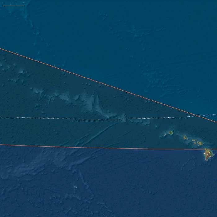
North Polynesia includes the Hawaiian Islands chain except Hawaiʻi Island (the Big Island) — principally Oʻahu, Maui, Kauaʻi, Molokaʻi, Lānaʻi, Niʻihau — plus Midway Atoll.
-
Anchors: Oʻahu’s twin shield ranges (Koʻolau, Waiʻanae) with deeply incised gulches; Kauaʻi–Niʻihau as the older high-island pair; Maui Nui as a broad, shallow platform with multiple emergent peaks; Midway Atoll as a carbonate cap on the subsiding Emperor–Hawaiian chain.
-
Sea level sat well below modern during glacial maxima, exposing wide reef flats and coastal benches.
Climate & Environmental Shifts
-
Late Pleistocene glacial climate: cooler SSTs, stronger trade-wind seasonality; broad coastal steppe–scrub around high-island skirts.
-
Episodic dust, stronger winter surf; reef growth pulsed between coolings.
Biota & Baseline Ecology (No Human Presence)
-
Seabird rookeries dense on offshore stacks and atolls (proto-Midway); Hawaiian monk seals hauled out on remote beaches.
-
Native forests atop ridges were a mosaic of cloud forest and dry woodland; streams were clear, with endemic fish/invertebrates.
Long-Term Significance
This epoch set the geomorphic template: high islands with fertile amphitheaters, narrow coastal plains, and nascent reef systems—conditions that would later support intensive Polynesian agro-ecologies.
West Polynesia (49,293 – 28,578 BCE): Upper Paleolithic I — Volcanic High Islands, Atoll Seeds, and Reef-Edge Biota
Geographic & Environmental Context
West Polynesia includes Hawaiʻi Island (the Big Island); Tonga (Tongatapu, Haʻapai, Vavaʻu); Samoa (Savaiʻi, Upolu, Tutuila/Manuʻa); Tuvalu and Tokelau (low atolls); the Cook Islands (Rarotonga, Aitutaki, Mangaia, etc.); Society Islands (Raiatea–Tahiti–Moʻorea–Bora Bora); and the Marquesas (Nuku Hiva, Hiva Oa).
-
Hawaiʻi Island still in an active shield-building phase (Mauna Loa, Mauna Kea); Societies, Marquesas, Cooks are high volcanic islands; Tuvalu–Tokelau are emergent low reef structures and paleo-atolls; Tonga–Samoa high islands/raised limestones.
Climate & Environmental Shifts
-
Glacial world: sea level ~100 m lower; wide reef flats and drowned shelves exposed terraces and benches. Trades strong; cooler SSTs.
Biota & Baseline (No Human Presence)
-
Seabird supercolonies, turtle rookeries, monk seals (in NW line) on outer cays; uplands carry cloud/montane forests, leeward slopes dry woodland.
-
Reef accretion proceeds episodically; lagoons are shallower and more extensive than today.
Long-Term Significance
A geomorphic blueprint forms: high islands with fertile amphitheaters and burgeoning barrier reefs—future foundations for intensive ridge-to-reef food systems.
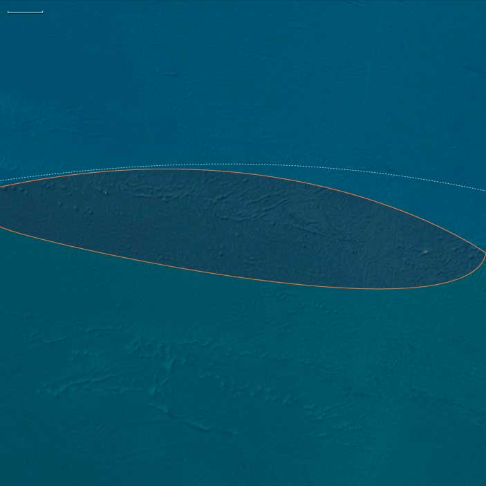
Polynesia (28,577 – 7,822 BCE): Late Pleistocene–Early Holocene Transition — Emerging Arcs, Drowned Plateaus, and Reef Foundations
Geographic & Environmental Context
During the Late Pleistocene and early Holocene, Polynesia—stretching from the Hawaiian archipelago across Samoa, Tonga, the Cook and Society Islands, to the far eastern outliers of Pitcairn and Rapa Nui—remained entirely unpeopled, a scattered constellation of volcanic and reefed islands rising above the world’s largest ocean.
At the Last Glacial Maximum (c. 26,500–19,000 BCE), global sea levels stood more than 100 m lower than today, exposing wide coastal shelves and tightening inter-island channels. As ice sheets melted, deglaciation flooded ancient shorelines, transforming basins into lagoons and seamounts into isolated atolls.
-
North Polynesia (Oʻahu, Maui Nui, Kauaʻi–Niʻihau, Midway Atoll): the Maui Nui shelf—once a single island—became a cluster of channels; Midway’s rim expanded as new lagoons formed.
-
West Polynesia (Hawaiʻi Island, Tonga, Samoa, Tuvalu–Tokelau, Cook, Society, and Marquesas): reefs and barrier lagoons built up around volcanic peaks, while low atolls appeared as sea level rose.
-
East Polynesia (Pitcairn, Rapa Nui, and nearby seamounts): the farthest outposts of the Pacific, geologically young and ecologically self-contained, fringed by narrow reef flats and rich upwelling zones.
Across this immense realm, oceanic currents—the South and North Equatorial and the Kuroshio–Equatorial Counter-flow system—created predictable gyres, establishing the hydrological backbone that would later sustain Polynesian voyaging.
Climate & Environmental Shifts
The epoch was one of oscillation and renewal:
-
Last Glacial Maximum (26,500–19,000 BCE): cooler seas and exposed shelves expanded coastal plains; coral growth slowed under lowered sea level.
-
Bølling–Allerød interstadial (c. 14,700–12,900 BCE): warmth and rainfall increased; reefs surged upward in “catch-up” growth; lagoons and barrier formations matured.
-
Younger Dryas (12,900–11,700 BCE): brief cooling flattened reef accretion and restricted mangroves; trade-wind aridity spread in leeward belts.
-
Early Holocene (after 11,700 BCE): steady warming and sea-level stabilization allowed coral terraces, mangroves, and strand forests to reach near-modern equilibrium.
By 7822 BCE, the Pacific climate engine had achieved its Holocene rhythm—warm, humid, and oceanically stable.
Biota & Baseline Ecology (No Human Presence)
Polynesia’s ecosystems reached pristine balance under rising seas:
-
Reefs and lagoons flourished with coral, mollusks, crustaceans, and reef fish (parrotfish, surgeonfish, mullet); spur-and-groove structures and back-reef ponds became marine nurseries.
-
Coastal vegetation—pandanus, beach heliotrope, ironwood, and grasses—rooted in guano-enriched sands; strand forests stabilized dunes.
-
Cloud-forests cloaked high islands such as Tahiti and Savaiʻi, while dry leeward slopes supported shrub and palm mosaics.
-
Seabirds nested in immense colonies; turtles hauled out on beaches; marine mammals frequented newly formed bays.
All existed in predator-free isolation, each island a laboratory of speciation and resilience.
Geomorphic & Oceanic Processes
As the sea rose, island landscapes underwent continuous re-sculpting:
-
Reef accretion kept pace with transgression, forming the first true atoll rings.
-
Maui Nui’s plateau fragmented into separate islands; Hawaiʻi Island’s volcanic plains met new coasts.
-
Eastern high islands (Rapa Nui, Pitcairn) gained fertile volcanic soils through slow weathering; storm surges and wave reworking created terraces and embayments.
-
Sediment deltas at stream mouths formed early estuarine wetlands—future sites for Polynesian fishponds and irrigated terraces.
Symbolic & Conceptual Role
For millennia these lands remained beyond the human horizon—unimagined yet forming the ecological architecture that would one day welcome voyagers. Their mountains, lagoons, and reefs became the stage on which later Polynesian societies would enact origin stories of sea and sky.
Environmental Adaptation & Resilience
Natural resilience was inherent:
-
Coral reefs tracked rising seas through vertical growth, preventing ecological collapse.
-
Guano-fertilized soils accelerated vegetative colonization after storm disturbance.
-
Cloud-forest hydrology maintained water flow even in drier pulses.
These feedbacks produced long-term equilibrium between land, sea, and atmosphere—the defining ecological rhythm of Polynesia.
Long-Term Significance
By 7,822 BCE, Polynesia had become a fully modern oceanic system: drowned plateaus transformed into lagoons and atolls; coral terraces and forest belts stabilized; seabird and reef ecologies reached peak diversity.
Though still empty of humankind, the region now possessed every element—predictable currents, fertile reefs, sheltered bays, and stable climates—that would, tens of millennia later, make it the natural cradle of the world’s greatest voyaging tradition.
North Polynesia (28,577 – 7,822 BCE): Upper Paleolithic II — Deglaciation, Rising Seas, and Reef Terraces
Geographic & Environmental Context
North Polynesia includes the Hawaiian Islands chain except Hawaiʻi Island (the Big Island) — principally Oʻahu, Maui, Kauaʻi, Molokaʻi, Lānaʻi, Niʻihau — plus Midway Atoll.
-
Anchors: Windward Oʻahu reef benches; Maui Nui’s now-flooding inter-island shelf (tightening channels between Maui–Molokaʻi–Lānaʻi); Kauaʻi–Niʻihau cliff coasts; Midway’s expanding lagoon rim.
Climate & Environmental Shifts
-
Deglaciation lifted sea level >100 m, drowning paleo-shorelines and pushing reefs landward into new terraces and embayments.
-
Bølling–Allerød warming then Younger Dryas snapback produced stepwise reef catch-up; Early Holocenewarmth stabilized growth.
Biota & Baseline Ecology (No Human Presence)
-
Reef accretion built coral terraces and spur-and-groove formations; nearshore lagoons teemed with parrotfish, surgeonfish, and mullet.
-
Seabird nutrient inputs (guano) enriched dune vegetation; coastal strand forests established on emerging sand spits.
Long-Term Significance
The migrating shoreline created productive lagoons and sheltered landings—future hubs for waʻa (canoe) anchorages and fishpond siting.
West Polynesia (28,577 – 7,822 BCE): Upper Paleolithic II — Deglaciation, Rising Seas, and Lagoon Maturation
Geographic & Environmental Context
West Polynesia includes Hawaiʻi Island (the Big Island); Tonga (Tongatapu, Haʻapai, Vavaʻu); Samoa (Savaiʻi, Upolu, Tutuila/Manuʻa); Tuvalu and Tokelau (low atolls); the Cook Islands (Rarotonga, Aitutaki, Mangaia, etc.); Society Islands (Raiatea–Tahiti–Moʻorea–Bora Bora); and the Marquesas (Nuku Hiva, Hiva Oa).
-
Anchors: Mauna Loa–Mauna Kea lava fields; Tongatapu–Haʻapai fringing lagoons; Rarotonga–Aitutaki reef flats; Raiatea–Tahiti leeward lagoons; Nuku Hiva embayments; Tuvalu–Tokelau reef rims.
Climate & Environmental Shifts
-
Deglaciation drives rapid sea-level rise; coastlines retreat landward; coral growth keeps pace, building spur-and-groove and back-reef ponds.
-
Bølling–Allerød warm spike then Younger Dryas cool snap; Early Holocene warmth stabilizes.
Biota & Baseline (No Human Presence)
-
Lagoons teem with mullet, surgeonfish, parrotfish; strand-forest and dune systems expand; montane cloud forests intact.
Long-Term Significance
Creation of stable lagoons and wetland back-beach ponds—ideal future sites for loko iʻa (fishponds) and irrigated terraces.
East Polynesia (28557 – 7822 BCE): The Far-Flung Isles of the Empty Ocean
Geographic and Environmental Context
East Polynesia—including the Pitcairn Islands, Easter Island (Rapa Nui), and nearby seamounts—formed the far eastern apex of the Polynesian Triangle.
-
These islands are oceanic in origin, volcanic or uplifted, and extremely isolated from any continental landmass.
-
During the Late Pleistocene, lower sea levels slightly increased land area on some islands, exposing coastal terraces and enlarging reef flats.
-
The surrounding Pacific was influenced by the South Equatorial Current, which brought warm waters year-round.
Climate and Environmental Shifts
-
Last Glacial Maximum (c. 26,500 – 19,000 BCE): Slightly cooler sea-surface temperatures and lowered sea levels affected reef growth rates; exposed coastal flats expanded nesting areas for seabirds and turtles. Rainfall remained moderate due to the islands’ equatorial–subtropical position.
-
Bølling–Allerød (c. 14,700 – 12,900 BCE): Warmer, wetter conditions boosted reef productivity; coastal vegetation flourished, and seabird populations increased.
-
Younger Dryas (c. 12,900 – 11,700 BCE): Modest cooling and seasonal rainfall variation slightly reduced vegetative growth rates, but ecosystems remained generally stable.
-
Early Holocene (after c. 11,700 BCE): Rising seas flooded exposed coastal terraces and reestablished modern shorelines; coral reefs expanded rapidly under warm, stable conditions.
Flora, Fauna, and Ecology
-
Terrestrial flora consisted of coastal strand plants, scrub, and limited inland forest, maintained by nutrient input from seabird guano.
-
Birdlife was abundant, with dense colonies of petrels, terns, frigatebirds, and shearwaters.
-
Marine life included coral reef ecosystems rich in fish, mollusks, crustaceans, and marine turtles.
-
With no human presence, all terrestrial and marine species existed in predator-free ecosystems, leading to the survival of ground-nesting seabirds in vast numbers.
Human Presence
-
No evidence of human visitation exists for this epoch; the islands were beyond the reach of even the most advanced late Pleistocene voyagers.
-
Their extreme remoteness meant they remained outside the known seascape of contemporary coastal peoples.
Environmental Dynamics
-
Reef flats and lagoons served as nurseries for fish and invertebrates.
-
Volcanic activity, though minimal in this period, influenced soil fertility on younger islands.
-
Seasonal storm systems occasionally reshaped beaches and coastal vegetation belts.
Symbolic and Conceptual Role
For human societies elsewhere in the Pacific, these lands lay entirely beyond the known horizon, neither visited nor imagined.
Transition Toward the Holocene
By 7822 BCE, East Polynesia’s islands had stable climates, fully developed reefs, and undisturbed terrestrial ecosystems. They would remain untouched by humans until the remarkable long-distance voyages of the late Holocene Polynesian navigators.
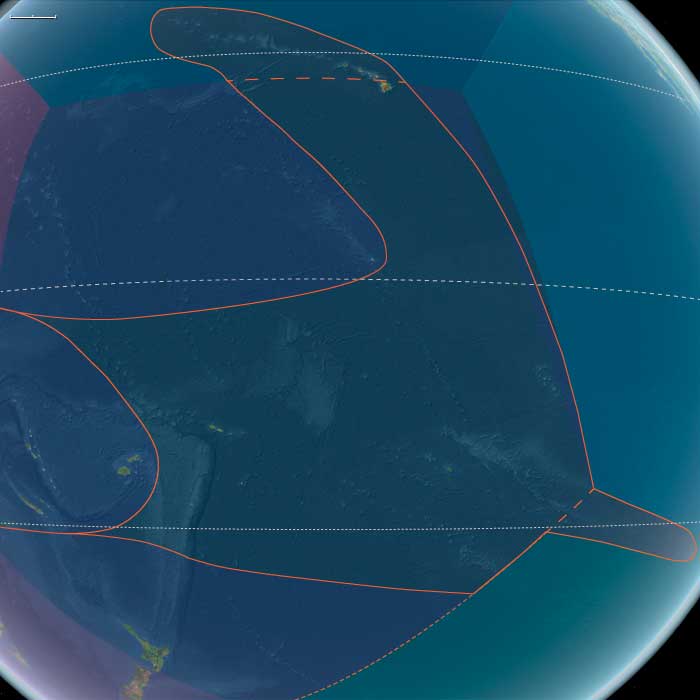
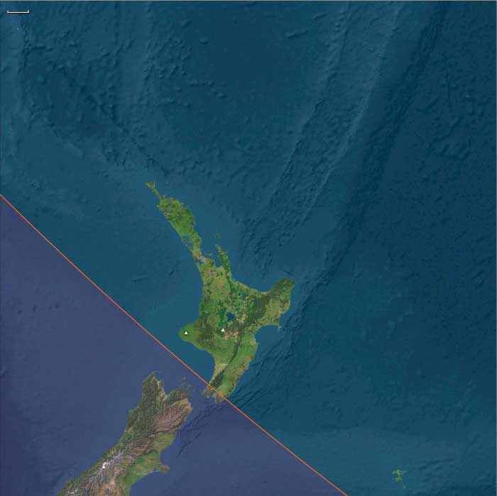
Central Oceania, the twelfth of the Earth’s regions centered on the South Pacific Ocean, encompasses the Hawaiian Islands, New Zealand’s North Island, and the archipelagos of Western Polynesia, Eastern Melanesia, and Eastern Micronesia. This includes groups such as French Polynesia, Tonga, Niue, the Cook Islands, Fiji, Tokelau, Vanuatu, the eastern Solomon Islands, Nauru, Tuvalu, Samoa, and the Marshall Islands.
Its northwestern boundary separates the Solomon Islands from the easternmost islands of Papua New Guinea, including Bougainville, Buka, and several outlying islands and atolls historically known as the Northern Solomons.
The southeastern boundary divides West Polynesia, which includes the Big Island of Hawaii, from East Polynesia, represented by the Pitcairn Islands and Easter Island.
HistoryAtlas contains 399 entries for Central Oceania from the Paleolithic period to 1899.Narrow results by searching for a word or phrase or select from one or more of a dozen filters.
There is no evidence of human beings having lived in Oceania before about 31,000 BCE.
If they did, they would have lived along the coasts of the various small islands, and evidence would have long since disappeared below the rising seas of the Holocene Epoch.