
Event
Andamanasia (1828–1971 CE): Colonial Conquest, Penal and…
Andamanasia (1828–1971 CE): Colonial Conquest, Penal and Plantation Corridors, and Uneven National Integration
Geographic Parameters
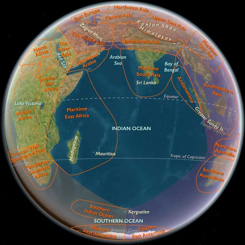
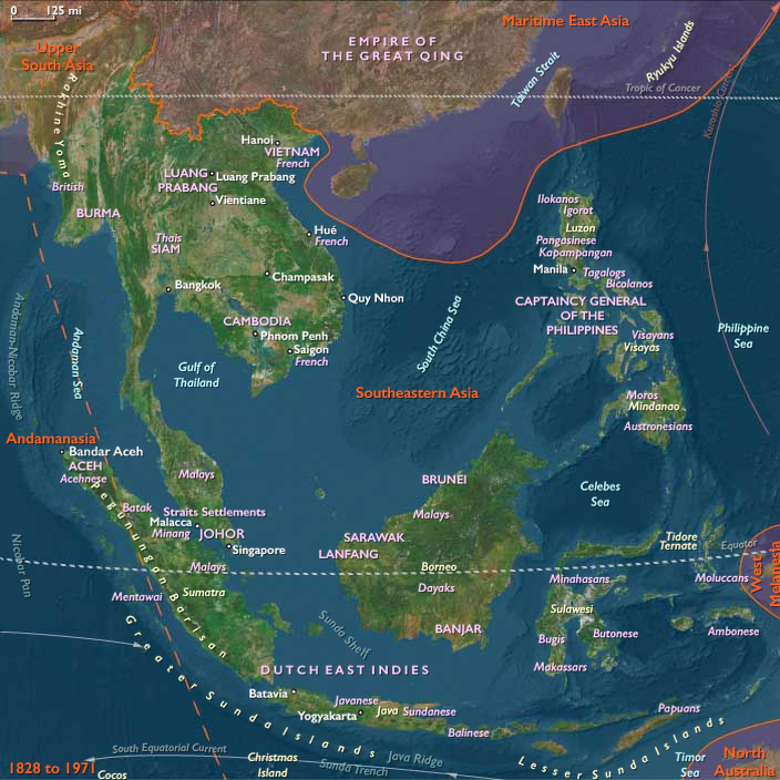
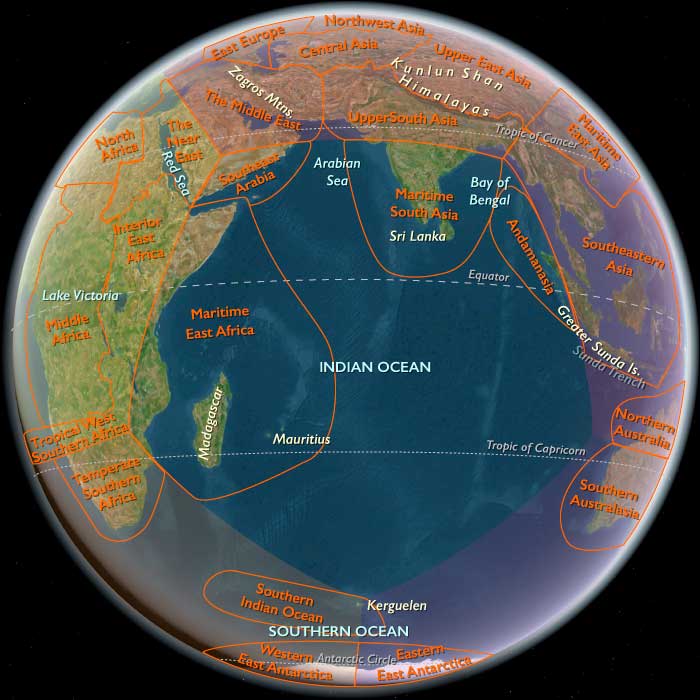
Andamanasia remained a fragmented maritime field extending from northern Sumatra across the Bay of Bengal and eastern Indian Ocean. It included Aceh at Sumatra’s northern end; Simeulue, Nias, the Batu Islands, and the Mentawai Islands along Sumatra’s western outer arc; the Andaman and Nicobar Islands; Preparis Island and the Coco island group; and the remote Cocos (Keeling) atolls.
During this age, these territories were incorporated into several expanding imperial and national systems. Aceh and the outer Sumatran islands were gradually subjected to the Netherlands East Indies. The Andaman and Nicobar Islands became colonial dependencies of British India, with Port Blair developing into a major penal and administrative settlement. Preparis and the Coco Islands entered British Burmese jurisdiction. Cocos (Keeling) became a privately dominated British plantation possession before its transfer to Australia in 1955.
Political incorporation remained profoundly uneven. Ports, prisons, roads, missions, military posts, plantations, airfields, and administrative settlements occupied selected corridors, while extensive rainforest, reef, garden, village, and Indigenous territories remained outside intensive development.
Environmental Continuity
Rainforest, river mouth, mangrove, estuary, rice valley, mixed garden, beach, reef, lagoon, tidal channel, and monsoon sea remained the underlying environmental structures of Andamanasia.
Aceh combined fertile rice-growing districts with pepper and areca gardens, fishing coasts, forested uplands, and river corridors. Colonial warfare damaged many of these productive systems, but village agriculture, household gardens, fishing, livestock, and religious communities repeatedly reconstituted local life.
Simeulue, Nias, Batu, and Mentawai retained heavily forested landscapes divided among river valleys, ridges, beaches, gardens, and canoe landings. Their inhabitants continued to rely on varied combinations of sago, rice or tubers where suitable, bananas, coconuts, pigs, fishing, hunting, and forest collection even as missions and colonial administrations attempted to reorganize settlement.
The Andaman Islands supported dense forests, mangrove creeks, reefs, and Indigenous hunting-and-gathering territories. British occupation added clearings, convict farms, sawmills, roads, docks, and settlements around Port Blair, but did not transform the whole archipelago into a continuous colonial landscape.
The Nicobars retained coconut, pandanus, tuber, pig, reef, and lagoon economies. Cocos became increasingly dominated by coconut production, although reefs, lagoon fisheries, household gardens, and imported provisions remained essential to the survival of its plantation population.
Climate, Seismicity, and Coastal Change
Monsoons continued to govern planting, fishing, coastal navigation, and shipping schedules. Cyclones periodically damaged the Andaman and Nicobar Islands, while drought, storm surge, erosion, and limited freshwater remained persistent problems on Cocos.
The outer Sumatran arc remained vulnerable to earthquakes and tsunamis. Settlement mobility, elevated houses, distributed gardens, forest access, and oral knowledge of dangerous sea behavior continued to reduce risk. The modern Simeulue term smong should not be projected unchanged across the whole age, but local memory of earthquakes, sea withdrawal, and high ground remained an important form of environmental adaptation.
Colonial forestry, plantation specialization, military construction, road cutting, and urban expansion introduced new ecological pressures. These changes were geographically concentrated rather than uniform. Much of Andamanasia remained environmentally continuous even as selected districts experienced extensive clearing, soil exhaustion, wildlife decline, or coastal disturbance.
The Principal New Organizing System
The principal new system of the age was territorial colonial integration through military, penal, missionary, plantation, transport, and administrative corridors.
Earlier European powers had influenced shipping and commerce without occupying most of Andamanasia. From the mid-nineteenth century, the Dutch and British increasingly attempted to claim land, move populations, regulate labor, suppress autonomous political systems, and connect selected islands to imperial ports and communications networks.
This new system did not erase earlier ones. Rice cultivation, forest use, household gardens, fishing, canoe travel, customary authority, Islamic learning, ancestor practices, and inter-island exchange continued beneath and around colonial infrastructure.
Aceh before the Dutch Invasion
During the opening decades of the age, the Aceh Sultanate remained independent and commercially active. Pepper-producing districts on the west and south coasts traded directly with British, American, French, and other merchants. The sultan retained international standing, while ulèëbalang, port chiefs, religious scholars, merchant families, and cultivators exercised substantial regional authority.
The Anglo-Dutch Treaty of 1824 divided British and Dutch spheres of influence in maritime Southeast Asia but did not itself transfer Aceh to the Netherlands. Dutch claims expanded gradually as the colonial state consolidated authority elsewhere in Sumatra.
Acehnese rulers and merchants continued to maneuver among foreign powers. The sultanate sought external recognition and assistance, while regional chiefs pursued their own commercial arrangements. This layered political order complicated Dutch attempts to treat Aceh as one state that could be conquered through the capture of a capital.
The Aceh War
The Netherlands invaded Aceh in 1873. Dutch officials expected a relatively rapid campaign, but the intervention developed into one of the longest and most destructive colonial wars in Southeast Asia.
The first expedition failed, and Dutch forces struggled against fortifications, difficult terrain, disease, decentralized leadership, and widespread resistance. The occupation of the royal center did not end the war. The sultanate’s authority, village networks, ulèëbalang, ulama, cultivators, and guerrilla groups continued the struggle through shifting coalitions.
Dutch conquest relied on fortified posts, naval blockades, roads, rail or tram connections in selected districts, intelligence networks, alliances with cooperative chiefs, mobile military columns, and punitive campaigns. Scorched-earth operations destroyed houses, fields, irrigation and drainage works, food stores, and livestock. The resulting hunger, displacement, and disease killed and traumatized large civilian populations as well as combatants.
Resistance became increasingly associated with Islamic obligation and martyrdom, though political motives remained diverse. Some regional chiefs negotiated with the Dutch, some changed allegiance, and others continued armed resistance after the sultan’s formal submission.
By the early twentieth century, the colonial state controlled major towns and transport corridors, but resistance persisted in localized forms. The war should therefore not be represented as ending neatly in 1904. Dutch military dominance emerged gradually and remained contested.
Colonial Aceh
After conquest, the Dutch sought to govern through a restructured combination of direct administration, military supervision, compliant ulèëbalang, and regulated Islamic institutions. Roads, government offices, schools, plantations, commercial facilities, and communications lines expanded in selected districts.
Rice, pepper, areca, coconuts, fishing, and village markets remained the productive base of much of Acehnese society. Colonial authorities promoted export production and taxation while attempting to separate religious authority from political resistance.
Islamic schools, mosques, scholars, and village communities preserved strong social influence. Reformist and modernist Muslim organizations emerged alongside older scholarly and Sufi traditions. The memory of the war reinforced the connection among Islam, Acehnese identity, anticolonial resistance, and claims to political autonomy.
Modern infrastructure remained corridor-based. It connected administrative towns, military posts, plantations, and ports without producing a uniformly urban or industrial landscape.
The Outer Sumatran Islands under Dutch Rule
Dutch incorporation of Simeulue, Nias, Batu, and Mentawai proceeded at different speeds and through different combinations of military intervention, treaties, missionization, taxation, schooling, and settlement regulation.
On Nias, Dutch campaigns and German Protestant missions altered the political balance among villages. Colonial authorities sought to suppress warfare, slave trading, autonomous fortifications, and the authority of local elites. Missions established congregations, schools, clinics, and new settlement forms.
Christianity spread widely, especially during the early twentieth century, but conversion did not erase customary law, kinship, stone monuments, carved houses, feasting traditions, or local identities. Existing knowledge of nineteenth- and early twentieth-century Nias depends heavily on colonial administrators and missionaries and must therefore be read critically.
Dutch power on Simeulue and Batu remained more limited and coastal. Administrative posts, missions, trade, and taxation linked the islands to Sumatra while household cultivation, fishing, village authority, and oral tradition remained central.
In the Mentawais, the colonial and scholarly category “Mentawaian” increasingly compressed communities that identified more specifically through islands, river valleys, houses, and kin groups. Colonial officials and missionaries attempted to concentrate settlements, prohibit or marginalize ritual specialists, alter clothing and longhouse life, and make populations more administratively legible.
These efforts produced selective conversion, relocation, resistance, concealment, and cultural adaptation rather than complete assimilation. Forest horticulture, hunting, household ritual, canoe movement, and attachment to specific river landscapes continued.
The British Penal Settlement in the Andamans
Britain permanently occupied the Andaman Islands in 1858 following the uprising of 1857. The immediate purpose was to imprison and exile rebels and convicts, but the colony also served broader ambitions to secure shipping routes, occupy territory, clear land, and create an economically productive settlement.
Between 1858 and 1939, British India transported approximately 83,000 Indian and Burmese convicts to the Andamans, making it the largest British penal colony by total convict receipts.
Convict labor cleared forests and constructed roads, docks, barracks, workshops, prisons, farms, administrative buildings, telegraph facilities, and water systems. Prisoners passed through varying regimes of chains, barrack confinement, assigned labor, conditional release, and “self-supporter” settlement. The system sought not merely to punish but to convert transported people into a permanent, disciplined colonial population.
The penal landscape extended far beyond the later Cellular Jail. It included forest camps, work gangs, farms, villages, sawmills, harbors, hospitals, roads, and smaller prisons. The Cellular Jail, constructed around the turn of the twentieth century, became a major site of political imprisonment and anticolonial memory but should not visually consume the entire archipelago.
Indigenous Dispossession in the Andamans
British settlement treated Indigenous land as available for occupation despite the existence of distinct Andamanese peoples with established territories and social systems. Colonial officers alternated among punitive violence, kidnapping, confinement, controlled “friendly contact,” medical intervention, segregation, and attempted assimilation.
The Great Andamanese suffered catastrophic population decline through introduced disease, violence, land loss, dependency, and social disruption. British roads, clearings, and settlements fragmented access to hunting, fishing, and gathering territories.
The Jarawa, Onge, Sentinelese, and other communities experienced different degrees of intrusion. Some resisted colonial entry for decades; others were confined or drawn into unequal exchanges with settlement authorities.
These peoples should not appear as static remnants beside a dynamic colonial settlement. Their continuing defense, adaptation, movement, and environmental knowledge remained active historical systems. Colonial demographic collapse was caused by invasion and imposed vulnerability, not by an inevitable inability to survive modernity.
The Nicobars under British Administration
Denmark abandoned its formal claims to the Nicobars in 1848. Britain annexed the islands in 1869 and established a penal station at Nancowry or Kamorta, which operated only briefly before closing in 1888.
British administration remained lighter and less transformative than in the Andamans. Officials, missionaries, traders, and surveyors entered the islands, but Nicobarese villages continued to control most cultivation, canoe movement, exchange, and social life.
Coconuts and other island products entered colonial trade, while imported cloth, iron, tools, and manufactured goods became more common. Missionary activity produced some conversions but did not eliminate local religious and ceremonial systems.
The Nicobars should therefore appear as an Indigenous village-and-garden landscape containing a small, weathered administrative or mission node, not as a continuous British colony.
Preparis and the Coco Islands
Preparis and the Coco Islands became parts of British Burma’s maritime frontier. Their strategic and navigational value exceeded their demographic or economic importance.
Small settlements, lighthouse or signaling installations, fishing camps, and administrative visits could appear where historically appropriate, but no large port or plantation system developed. Their incorporation was primarily cartographic, naval, and administrative.
After Burmese independence in 1948, they became part of Burma, later Myanmar, while remaining lightly populated and strategically controlled.
Cocos Plantation Society
Cocos (Keeling) developed into a coconut-oil and copra plantation society under the Clunies-Ross family. In 1886, the British Crown granted the islands to George Clunies-Ross and his heirs.
The estate exercised extraordinary control over land, employment, trade, housing, movement, and access to outside institutions. The laboring population, drawn mainly from the Malay-Indonesian world and formed partly through coercive migration, developed into the distinct Cocos Malay community.
Cocos Malay society was Muslim and maintained its own kinship systems, language, foodways, music, dance, boats, neighborhood organization, and religious practices. Community life should not be reduced to plantation labor or European proprietorship.
Copra production remained geographically extensive within the tiny atoll but materially simple: coconut groves, drying sheds, storage buildings, small boats, household compounds, and one proprietor’s estate. The lagoon, reef, fishing grounds, gardens, and settlement lanes remained visible around this plantation system.
Steamship, Telegraph, and Communications Corridors
Steam navigation shortened travel times and connected selected ports more reliably to colonial centers. Telegraph and cable installations increased the strategic significance of Port Blair and Cocos. Lighthouses, charts, docks, repair facilities, and regular mail services made the archipelago more legible to imperial administration.
These systems remained uneven and fragile. Small boats were still required to reach shallow landings and outer villages. Monsoons, reefs, storms, silting, and isolation continued to interrupt transport.
Cocos became especially important as an imperial communications node. During the First World War, the German cruiser Emden attacked the cable station before being engaged by HMAS Sydney. During the Second World War, Allied forces built an airstrip and expanded military facilities.
Communications infrastructure should remain one limited corridor rather than converting Cocos into a major industrial or naval island.
Missionization and Cultural Change
Christian missions became influential on Nias and in selected outer-island and Nicobarese communities. Mission compounds often combined churches, schools, clinics, houses, gardens, and workshops.
Missionization altered literacy, settlement patterns, ritual authority, architecture, marriage, education, and relations with colonial administration. It also provided new forms of community organization and access to medicine or schooling.
Conversion was neither instantaneous nor complete. Christian practice could coexist with customary law, ancestor relations, local healing, ritual prohibitions, ceremonial exchange, and clan identity. Indigenous people selectively reinterpreted missionary institutions rather than merely receiving them.
In Aceh, Islamic schools and reform movements played a comparable role in expanding literacy and collective organization while resisting Dutch cultural authority.
Japanese Occupation
Japan occupied Aceh and the outer Sumatran islands after defeating the Dutch East Indies in 1942. Dutch authority collapsed, but Japanese rule brought military requisitioning, forced labor, surveillance, food shortages, and political repression.
Japanese administrators mobilized Islamic and nationalist organizations while attempting to channel them toward imperial objectives. Wartime occupation weakened Dutch institutions and expanded Indonesian political organization, but it imposed severe hardship on local populations.
The Japanese Empire occupied the Andaman and Nicobar Islands from March 1942 until 1945. British officials abandoned Port Blair, and Japanese forces took over existing administrative, prison, harbor, and communications infrastructure.
Occupation brought forced labor, food requisitions, arrests, torture, executions, and fear of espionage. Nominal transfer of the islands to Subhas Chandra Bose’s Provisional Government of Free India did not remove Japanese military control. Bose visited Port Blair in December 1943, while actual administration remained under the occupation forces.
Cocos remained under Allied control. Military administration, communications facilities, and the wartime airstrip occupied a selected part of the atoll while plantation labor and Cocos Malay community life continued.
Indonesian Independence and Acehnese Politics
Following Japan’s surrender, Acehnese religious leaders, merchants, youth organizations, and armed groups supported the Republic of Indonesia against the attempted restoration of Dutch rule. Aceh supplied money, material, personnel, and secure territory to the republican cause.
The social revolution of 1945–1946 violently displaced much of the old ulèëbalang elite and increased the authority of ulama and republican organizations. Independence therefore transformed internal Acehnese politics as well as ending Dutch rule.
Relations with Jakarta soon became contentious. The incorporation of Aceh into the larger province of North Sumatra, disputes over religious authority, and dissatisfaction with central administration contributed to the Darul Islam rebellion led by Daud Beureueh in 1953. The rebellion sought participation in an Indonesian Islamic state rather than immediate Acehnese national independence.
Most rebel leaders reached agreements with the Indonesian government by 1959, when Aceh received special regional status in religion, education, and customary affairs. Daud Beureueh’s resistance ended in 1962.
By 1971, Indonesian roads, schools, government offices, military posts, health services, and commercial networks had expanded, but village agriculture, fishing, Islamic institutions, and local identity remained dominant across much of Aceh.
Outer Sumatran Islands within Indonesia
Simeulue, Nias, Batu, and Mentawai became parts of independent Indonesia. National administration expanded through schools, clinics, missions, coastal shipping, district offices, airstrips, roads, and programs intended to standardize village organization.
On Nias, Christianity became a major public institution while customary law, clan identity, stone architecture, feasting traditions, and village organization persisted in modified forms.
In Mentawai, state and mission programs often sought to move communities from dispersed longhouses into standardized roadside or coastal villages. Ritual practices and forest-based lifeways were stigmatized as obstacles to development. Yet local communities continued to maintain household, river-valley, forest, and ancestral identities despite the increasingly generalized external category of “Mentawai.”
Integration remained limited by distance, difficult terrain, weak transport, and the continuing importance of subsistence production. The national state was visible through selected nodes rather than uniformly present across every island.
India and the Postcolonial Andamans
The Andaman and Nicobar Islands became part of independent India in 1947. Port Blair remained the principal administrative, transport, and military center.
Postcolonial development expanded settlement rather than restoring Indigenous territorial autonomy. Refugees and migrants from the Indian mainland were resettled on cleared land. Forestry, agriculture, roads, schools, ports, and military facilities increased pressure on Indigenous reserves and surrounding ecosystems.
The Andaman and Nicobar Islands (Protection of Aboriginal Tribes) Regulation of 1956 created reserved territories, but the policy remained paternalistic and was imposed without Indigenous political participation. Protection coexisted with continuing encroachment, road proposals, dependency, and state control.
The postcolonial state inherited many assumptions of British development: forests and “unused” land were treated as resources available for settlement, extraction, and strategic occupation. The transition from empire to nation therefore did not end Indigenous dispossession.
Cocos under Australian Administration
Cocos became an Australian territory on 23 November 1955. Before that transfer, it had been administered through British Ceylon and Singapore.
Australian officials introduced a limited administrative presence, communications, public works, and welfare services. The Clunies-Ross family nevertheless continued to own most land and dominate plantation production through 1971.
Cocos Malays remained subject to restrictive labor and economic conditions while maintaining mosque-centered community life, kinship, language, maritime skills, and cultural traditions.
The age ends before the Australian government’s later purchase of most Clunies-Ross land and before the 1984 act of self-determination. In 1971, the plantation order remained firmly visible.
Infrastructure and Spatial Restraint
By the end of the age, Andamanasia contained artillery posts, colonial offices, churches, mosques, schools, prisons, roads, rail or tram segments, sawmills, plantation sheds, telegraph stations, radio masts, airstrips, motorboats, trucks, and larger port facilities.
These systems did not become universal. Their proper geographic distribution was sharply limited:
- a military-administrative corridor in Aceh;
- selected roads and mission centers on outer Sumatran islands;
- the penal and administrative district around Port Blair;
- small British stations in the Nicobars;
- limited Burmese installations on Preparis and the Cocos;
- a plantation, cable, and airfield corridor on Cocos (Keeling).
Between them remained rainforest, village gardens, rice fields, reef flats, fishing beaches, canoe routes, mangrove channels, undeveloped shoreline, and extensive Indigenous or customary territories.
Conflict, Forced Labor, and Displacement
The age was shaped by unusually intense coercion. The Aceh War brought invasion, village destruction, famine, displacement, and mass death. Dutch campaigns and missions disrupted outer-island political and ritual systems.
The Andaman penal colony transported tens of thousands of people through forced migration and used convict labor to construct colonial infrastructure. Indigenous Andamanese communities suffered disease, kidnapping, territorial loss, and demographic collapse.
Cocos plantation labor was controlled through isolation, dependency, private ownership, and restricted economic alternatives. Japanese occupation introduced additional forced labor, executions, requisitioning, and imprisonment.
These histories should be addressed directly but not converted into theatrical suffering or military spectacle. Their visual expression belongs in damaged fields, abandoned houses, controlled compounds, guarded roads, work parties, displaced settlement, forest clearance, and unequal access to shore and infrastructure.
Adaptation and Resilience
Acehnese communities rebuilt rice fields, gardens, mosques, schools, and village networks after warfare. Islamic scholarship and memory preserved political identity through Dutch rule, Japanese occupation, and conflict with the Indonesian central government.
Nias and Mentawai communities adapted Christian, colonial, and national institutions to local kinship and customary systems. Nicobarese villages maintained gardens, pigs, canoe networks, and ceremonial exchange despite administrative intrusion.
Andamanese peoples retained distinct territories and cultural knowledge under catastrophic pressure. Survival took different forms: armed territorial defense, avoidance, controlled contact, relocation, community reconstruction, and the preservation of forest-and-sea knowledge.
Cocos Malays transformed a coercively organized plantation population into a durable island society. Household life, Islam, language, kinship, boats, lagoon use, and community ritual gave continuity to a landscape otherwise dominated by one private estate.
Legacy of the Age
By 1971 CE, Andamanasia had been divided among Indonesia, India, Burma, and Australia, but national borders did not produce uniform social or environmental integration.
Aceh had passed through Dutch invasion, prolonged colonial war, military occupation, Japanese rule, Indonesian revolution, and Darul Islam rebellion. It remained strongly Islamic, agriculturally productive, and conscious of its history of sovereignty and resistance.
Simeulue, Nias, Batu, and Mentawai were incorporated into Indonesia through missions, schools, roads, district administration, and coastal trade, yet local village, kinship, religious, and forest-based systems remained active.
The Andaman Islands had been transformed by penal transportation, colonial settlement, Japanese occupation, and postcolonial migration. The Nicobars experienced more limited external settlement but shared the same Indian territorial administration. Indigenous communities endured, although disease, dispossession, and development had sharply reduced their demographic and territorial security.
Preparis and the Coco Islands remained peripheral but strategically governed parts of Burma. Cocos (Keeling) had become an Australian territory, while the Clunies-Ross estate still controlled most land and plantation production.
The age’s principal development was therefore the imposition of colonial and national territorial corridors upon a fragmented archipelagic field. Prisons, plantations, roads, missions, ports, military compounds, communications systems, and airfields became historically decisive, but none formed a complete regional landscape. Rainforest, rice valley, mixed garden, reef, canoe landing, fishing settlement, mosque neighborhood, customary village, and Indigenous territory continued around and between them.

-
{# Image navigates to the detail page; the magnifying-glass chip is the only Fancybox lightbox trigger (kept a separate sibling — anchors can't nest). #}
 The Indian Ocean Lands
World
The Indian Ocean Lands
World
-
{# Image navigates to the detail page; the magnifying-glass chip is the only Fancybox lightbox trigger (kept a separate sibling — anchors can't nest). #}
 Southeast Asia
Region
Southeast Asia
Region
-
{# Image navigates to the detail page; the magnifying-glass chip is the only Fancybox lightbox trigger (kept a separate sibling — anchors can't nest). #}
 Andamanasia
Subregion
Andamanasia
Subregion
People
None linked.
Locations
None linked.
Cite this entry
Moran, J. (2026). Andamanasia (1828–1971 CE): Colonial Conquest, Penal and Plantation Corridors, and. History Atlas. Retrieved 22 September 2026, from https://www.historyatlas.com/events/andamanasia-18281971-ce-colonial-conquest/
Related events
Loading related events…