Al Andalus, as Islamic Spain is called,…
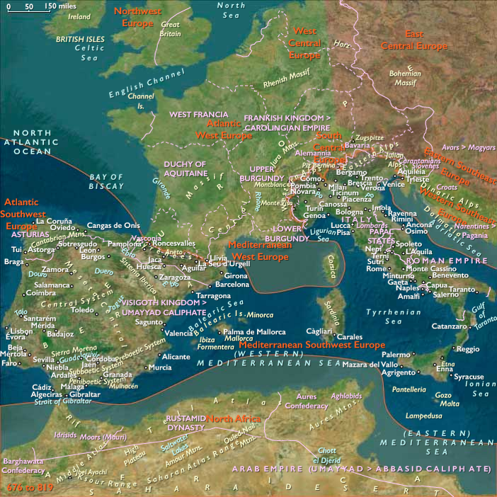
676 CE to 819 CE
Al Andalus, as Islamic Spain is called, is organized under the civil and religious leadership of the caliph of Damascus.
Governors in Spain are generally Syrians, whose political frame of reference is deeply influenced by East Roman (Byzantine) practices.
Nevertheless, the largest contingent of Moors in Spain consists of the North African Berbers, recent converts to Islam, who are hostile to the sophisticated Arab governors and bureaucrats and are given to a religious enthusiasm and fundamentalism that are to set the standard for the Islamic community in Spain.
Berber settlers fan out through the country and make up as much as twenty percent of the population of the occupied territory.
The Arabs constitute an aristocracy in the revived cities and on the latifundios that they have inherited from the Romans and the Visigoths.
Most members of the Visigothic nobility convert to Islam, and they retain their privileged position in the new society.
The countryside, only nominally Christian, is also successfully Islamized.
Nevertheless, an Hispano-Roman Christian community survives in the cities.
Moreover, Jews, who constitute more than five percent of the population, continue to play an important role in commerce, scholarship, and the professions.
Groups
Subjects
Regions
Southwest Europe
View →Subregions
Mediterranean Southwest Europe
View →Related Events
No active filters.
Showing 10 events out of 56221 total
We begin in the easternmost subregions and move westwardly around the globe, crossing the equator as many as six times to explore ever shorter time periods as we continue to circle the planet. The maps of the regions and subregions change to reflect the appropriate time period.
Narrow results by searching for a word or selecting from one or more of a dozen filters.
Northeast Asia (676–819 CE): Toward Satsumon and the Okhotsk Sphere
Northeast Asia includes eastern Siberia east of the Lena River to the Pacific, the Russian Far East (excluding the southern Primorsky/Vladivostok corner), northern Hokkaidō (above its southwestern peninsula), and extreme northeastern Heilongjiang.
Anchors
- Lower Amur chiefdoms
- Mohe-related communities
- Sakhalin maritime routes
- Okhotsk coastal settlements
- northern Hokkaidō Satsumon transition
Climate & Environmental Conditions
Reliable fisheries, marine mammal resources, and forest productivity continued supporting dense regional populations.
Subsistence & Settlement
The region developed a mature tri-zonal economy:
- riverine storage systems
- coastal sealing and whaling
- inland hunting and trapping
Larger settlements appeared at key exchange points.
Technology & Material Culture
Iron became integrated into daily life.
Common features included:
- iron knives and awls
- toggling harpoons
- soapstone lamps
- skin-waterproofing technologies
- improved woodworking
Movement & Interaction Corridors
Major routes linked:
- Amur basin
- Sakhalin
- Hokkaidō
- northern Japan
- Okhotsk coast
Movement of metals, ceramics, oils, and furs intensified.
Cultural & Symbolic Expressions
Bear-sending ceremonies, salmon rituals, lineage identities, and ancestor traditions remained central.
Environmental Adaptation & Resilience
Regional specialization reached its highest level while preserving ecological flexibility.
Legacy & Transition
By 819 CE, Northeast Asia exhibited the cultural foundations of the medieval Okhotsk sphere and early Satsumon communities, setting the stage for later Ainu ethnogenesis and North Pacific interaction networks.
Northwestern North America (676–819 CE): Toward Thule and the Classic Northwest Coast
Geographical Parameters
(Same as above.)
Anchors
- Norton–Birnirk transition zones
- North Slope marine communities
- Haida Gwaii
- Central Coast longhouse polities
- Fraser and Columbia salmon towns
- Puget Sound
Climate & Environmental Conditions
Productive fisheries continued supporting increasingly specialized regional economies.
Subsistence & Settlement
A mature tripartite system emerged:
- Arctic marine specialists
- ranked coastal longhouse societies
- interior salmon-storage towns
Large permanent settlements appeared at key fisheries and exchange nodes.
Technology & Material Culture
- Birnirk marine technologies
- large sea-going canoes
- extensive storage facilities
- oil-processing systems
- refined woodworking traditions
Movement & Interaction Corridors
Grease trails, canoe highways, river systems, and Arctic marine routes connected the region.
Cultural & Symbolic Expressions
Lineage systems, ceremonial exchange, first-salmon traditions, and marine ceremonialism reinforced regional identities.
Environmental Adaptation & Resilience
The region possessed one of the most resilient resource networks in the world through the combination of storage, mobility, and ecological specialization.
Legacy & Transition
By 819 CE, Northwestern North America contained the foundations of both the classic Northwest Coast florescence and the Birnirk societies that would soon contribute to the Thule expansion.
Punuk Culture (676–819 CE)
Large Villages, Whale Hunting, and the Maturation of the Thule Tradition
By the late 7th century CE, the Punuk culture emerged across the islands of the Bering Strait and the Chukchi Peninsula, representing a clear development out of earlier Old Bering Sea (OBS) and Okvik traditions. While these earlier phases were renowned for their artistry in ivory and compact, semi-subterranean settlements, the Punuk stage marked a decisive shift toward larger villages, intensified whale hunting, and new forms of social organization.
Archaeological evidence shows Punuk settlements clustering along the major Strait islands (St. Lawrence, Diomedes, Punuk group) and extending onto the Siberian and Alaskan coasts. Unlike the smaller OBS dwellings, Punuk houses were larger, square or rectangular subterranean structures, carefully engineered for insulation. Their walls and roofs were supported by massive whale jawbones, reinforced with driftwood, and covered with sod and skins. With only low entrances visible above ground, these houses retained warmth through long winters, reflecting architectural ingenuity in the unforgiving Arctic climate.
The artifact styles of the Punuk stage also distinguish it from earlier OBS forms. Harpoon heads and hunting implements became standardized in shape, reflecting a culture increasingly oriented toward whale hunting rather than smaller marine mammals. The artistry of ivory carving continued, but with a shift toward simpler, more functional motifs compared to the exuberant curvilinear designs of the OBS. This suggests that social emphasis was moving from symbolic display toward practical efficiency in large-scale hunts and cooperative subsistence.
Whale hunting became the hallmark of Punuk life. The remains of bowhead and gray whales in settlement middens attest to organized, communal hunts that required coordination, large boats, and substantial labor. This reliance on whales not only increased food security but also facilitated larger and denser settlements, as whale harvests could support bigger populations.
In cultural terms, the Punuk horizon signals the consolidation of the Thule trajectory in the Bering Strait. Communities were no longer small, mobile bands but village societies with durable architecture, cooperative whale hunts, and broader exchange networks stretching across the Strait. This stability allowed the Punuk tradition to flourish and paved the way for the full-fledged Thule migrations eastward into Arctic Canada and Greenland in the centuries to come.
Polynesia (676–819 CE): Chiefly Horizons, Sacred Genealogies, and the Oceanic Web
Geographic & Environmental Context
By the late 7th and early 9th centuries CE, Polynesia had fully matured as a cultural world—its islands scattered across a vast triangle stretching from Hawai‘i (North Polynesia) to Tonga and Samoa (West Polynesia) and to the far-flung eastern arc of Mangareva, Pitcairn, and Rapa Nui (East Polynesia).
The region comprised a spectrum of environments: high volcanic islands such as Tongatapu, Upolu, Tahiti, and Hawai‘i with fertile soils and perennial streams; mid-ocean atolls such as Tokelau, Tuvalu, and the Cooks dependent on rainwater and lagoon productivity; and the dry, isolated islands of the far southeast where ingenious field systems emerged. Despite their remoteness, these island worlds were joined by voyaging canoes, kinship alliances, and ritual exchanges that carried ideas, crops, and people across thousands of kilometers.
Climate & Environmental Shifts
The late Holocene climatic stability persisted across the Pacific. Trade winds blew reliably, seas were calm enough for open-ocean voyages, and ENSO variability remained modest. High islands enjoyed dependable rainfall that sustained breadfruit, banana, and taro agriculture, while atolls relied on coconuts, fish, and preserved breadfruit. Only in the eastern outliers did dryness and wind pose serious challenges—factors that spurred early Polynesian innovation in rock-mulch gardening and rain-fed irrigation.
Societies & Political Developments
West Polynesia: Hierarchies and Monumental Foundations
In Tonga, Samoa, and the Cook and Society Islands, population growth and inter-island competition gave rise to stratified chiefdoms. The Tu‘i Tonga dynasty began to consolidate authority, erecting massive earthen and stone mounds (langi) that anchored sacred kingship. Samoa maintained a federated chiefly system—matai councils of lineage heads balancing consensus and prestige. Across the region, authority blended divine ancestry with pragmatic leadership, expressed in ceremonies of kava drinking, tattooing, and oratory. Monumental platforms and marae sanctuaries symbolized unity between ancestors, land, and sea.
North Polynesia: Consolidation and Cultural Refinement
In Hawai‘i and the northern chain, societies became more territorial and structured, their valleys divided among chiefly lines (ali‘i). Irrigated taro terraces expanded in O‘ahu and Maui’s windward valleys; fishponds (loko i‘a) were engineered to capture tides and breed mullet. Ritualized chiefly exchanges—feasting, dancing, and tribute distribution—strengthened social cohesion. While navigation routes between Hawai‘i and the central Pacific likely thinned, local voyaging remained vigorous among the northern islands.
East Polynesia: Frontier Communities and Ancestral Memory
Far to the southeast, settlers in Mangareva, Pitcairn, and Rapa Nui lived in isolation, maintaining small but resilient societies. Chiefs presided over kin-based villages cultivating taro, yam, and sweet potato in terraces and rock gardens. Ahu shrines and standing stones emerged as ancestral foci—the embryonic stage of the moai tradition that would later define Rapa Nui. Canoes connected these islands intermittently, sustaining exchange in stone tools, shell ornaments, and genealogical lore. Here, voyaging became both a practical necessity and a sacred remembrance.
Economy & Exchange Networks
Across Polynesia, horticulture and arboriculture formed the economic base—taro, yam, breadfruit, banana, and coconut supplemented by pigs, chickens, and dogs introduced generations earlier.
-
West Polynesia exported shell valuables and basalt adzes through Tonga–Samoa–Fiji circuits.
-
North Polynesia relied on local specialization: irrigated taro inland, salt and fish from coasts.
-
East Polynesia used inter-island reciprocity to mitigate ecological limits.
Voyaging remained integral: double-hulled canoes carried goods, spouses, and genealogies; their movement stitched the region into a maritime commonwealth of mutual awareness, even as local identities deepened.
Technology & Material Culture
The lashed-lug canoe with mat sails epitomized Polynesian mastery of wood, fiber, and hydrodynamics. Stone adzes, coral files, and shell scrapers refined woodworking and house construction. Fine tapa cloth, dyed red, black, or yellow, became a medium of tribute and ceremony. Ornaments in whale ivory, shell, and bone displayed chiefly status. In the east, basalt and coral tools from Mangareva and Pitcairn circulated in small but steady exchange spheres.
Cultural & Symbolic Expressions
Polynesian cosmology centered on genealogy (whakapapa, gafa)—the sacred chain linking gods, chiefs, and commoners. Myths of Tangaloa, Tane, and Pele described creation through navigation and transformation.
Ritual life unfolded in marae and heiau—open-air temples marked by coral or basalt pavements where offerings and kava libations honored gods and ancestors. Song, dance, and tattooing codified memory, rank, and identity. Across the ocean, shared motifs—spiral designs, triangular tattoos, red sacred coloration—testify to a living network of cultural dialogue.
Environmental Adaptation & Resilience
-
Tonga and Samoa: irrigated taro and arboriculture balanced protein from lagoons.
-
Hawai‘i: fishpond systems, diversified valley agriculture, and ritual resource management sustained dense populations.
-
Rapa Nui: stone-mulch gardens and windbreaks stabilized soils.
-
Atolls: preserved breadfruit paste, coconut water, and dried fish underpinned food security.
Polynesians treated ecology as a sacred partnership—land (fenua, ʻāina) and sea (moana) were both kin and deity.
Movement & Interaction Corridors
West Polynesia remained the political and ritual center, radiating influence outward through marriage alliances, kava rites, and trade. Central Polynesian canoes ventured along the Tonga–Samoa–Cook–Tahiti axis, while smaller craft maintained contact across the Tuvalu–Tokelau–Pukapuka chain. The far east and north were increasingly autonomous, but oral traditions preserved the idea of a connected “sea of islands,” navigable through shared stars and genealogies.
Transition (After 819 CE)
By the early 9th century, Polynesia had reached a cultural equilibrium:
-
West Polynesia anchored a network of monumental chiefdoms under the rising Tu‘i Tonga.
-
North Polynesia fostered intricate irrigation, aquaculture, and lineage-based leadership.
-
East Polynesia, though remote, developed distinct ancestral monuments that anticipated later innovation.
This was an age of stability and synthesis—when Polynesian societies balanced expansion and rootedness, hierarchy and reciprocity, and the sacred ocean continued to bind their far-flung worlds into one cultural continuum.
North Polynesia (676–819 CE)
Early Polynesian Settlement and Development
Polynesian seafarers are renowned for their extraordinary ocean navigation and astronomical knowledge. At a time when Western vessels rarely ventured out of sight of land, Polynesians regularly undertook extensive voyages, covering vast distances across the Pacific Ocean.
The early settlement history of Hawaiʻi remains somewhat uncertain; however, substantial archaeological and paleoecological evidence supports human habitation of the Hawaiian archipelago by 800 CE, possibly dating back as early as 300–500 CE. Many researchers suggest that these initial Polynesian settlers originated from the Marquesas Islands.
Upon arrival, these early Polynesians brought with them essential clothing, plants, and livestock, quickly establishing settlements along coastal regions and within larger valleys. Their agricultural practices prominently featured crops like kalo (taro), maiʻa (banana), niu (coconut), and ulu (breadfruit). They also raised animals such as puaʻa (pigs), moa (chickens), and the ʻīlio (poi dog), although meats were consumed less frequently compared to vegetables, fruits, and seafood.
Staple condiments included paʻakai (salt), ground kukui nut, limu (seaweed), and ko (sugarcane), which served both culinary and medicinal purposes. Additionally, the settlers soon incorporated ʻuala (sweet potato) into their diet. This introduction of the sweet potato, native to South America, remains a mystery, leading some researchers to speculate on pre-Columbian transoceanic contacts between Polynesia and the Americas.
The early Polynesians constructed hale (homes) and sacred heiau (temples) as they settled into their new environment. Archaeologists currently suggest that the earliest communities were established at the southern end of the Hawaiian archipelago, particularly on the Big Island of Hawai'i, with settlements gradually extending northwards along coastal areas and easily accessible river valleys. As the population expanded, communities increasingly moved inland, adapting to diverse ecological niches and fostering complex societies that would flourish in the centuries to come.
North Polynesia (676–819 CE): Threshold of Discovery
Geographical Parameters
North Polynesia includes the Hawaiian Islands chain except Hawaiʻi Island (the Big Island)—principally Oʻahu, Maui, Kauaʻi, Molokaʻi, Lānaʻi, Niʻihau—and Midway Atoll.
Anchors
- Kauaʻi reef passes
- Oʻahu valleys
- Maui Nui canoe landfalls
- Midway Atoll
Climate & Environmental Conditions
Trade-wind routes and swell patterns provided increasingly reliable pathways into the northern Pacific.
Ecological Baseline
Still effectively pristine.
However, Polynesian navigators were now approaching the technological capability required for sustained Hawaiian colonization.
West Polynesia (676–819 CE): Chiefly Consolidation, Monumental Beginnings, and Oceanic Networks
Geographical Parameters
West Polynesia includes Hawaiʻi Island (the Big Island); Tonga (Tongatapu, Haʻapai, Vavaʻu); Samoa (Savaiʻi, Upolu, Tutuila/Manuʻa); Tuvalu and Tokelau; the Cook Islands (Rarotonga, Aitutaki, Mangaia, etc.); the Society Islands (Raiatea–Tahiti–Moʻorea–Bora Bora); and the Marquesas (Nuku Hiva, Hiva Oa).
Anchors
Core settled heartland
- Tongatapu
- Haʻapai
- Vavaʻu
- Savaiʻi
- Upolu
Peripheral spheres
- Tuvalu
- Tokelau
- Cook Islands
- Society Islands
- Marquesas
- Hawaiʻi Island (still uncolonized)
Climate & Environmental Conditions
Reliable trade winds, fertile volcanic soils, protected lagoons, and productive reef systems supported some of the most successful island economies in Oceania.
Breadfruit groves, taro systems, coastal fisheries, and canoe corridors formed integrated ridge-to-reef landscapes.
Subsistence & Settlement
Large villages clustered around:
- reef passages
- sheltered canoe landings
- freshwater valleys
- taro-producing wetlands
Agroforestry mosaics combined:
- breadfruit
- coconut
- banana
- yam
- taro
with reef fisheries and offshore voyaging.
Settlements became increasingly permanent and organized.
Technology & Material Culture
- double-hulled voyaging canoes
- refined sail technologies
- polished adzes
- shell ornaments
- basalt tools
- specialized canoe construction
Navigation traditions reached mature forms capable of supporting long-distance exploration and colonization.
Society & Political Structure
Chiefly hierarchies became increasingly formalized.
Tonga developed the strongest stratification, while Samoa maintained lineage-centered chiefly systems.
Ceremonial landscapes expanded through:
- marae
- malae
- sacred enclosures
- raised platforms
- early monument traditions
These should appear as components of broader landscapes rather than as focal monuments.
Movement & Interaction Corridors
The Tonga–Samoa–Fiji triangle functioned as the primary exchange core.
Canoe routes linked:
- Tonga
- Samoa
- Fiji
- Tuvalu
- Tokelau
while exploratory voyages increasingly reached farther east and north.
Movement of:
- crops
- marriage alliances
- ritual traditions
- navigation knowledge
helped unify the Polynesian world.
Cultural & Symbolic Expressions
Genealogical traditions, ceremonial exchange, tattooing, dance, kava rituals, and sacred landscapes reinforced chiefly authority and regional identity.
Navigation lore remained one of the defining intellectual traditions of the region.
Environmental Adaptation & Resilience
Agroforestry, reef management, crop diversification, and inter-island exchange produced unusually resilient island systems.
The combination of:
- horticulture
- fisheries
- arboriculture
- voyaging
created a durable economic foundation across the archipelago.
Transition
By 819 CE, West Polynesia had become a mature network of interconnected chiefdoms whose ceremonial traditions, navigation systems, agroforestry economies, and exchange networks formed the cultural core from which later Polynesian expansion into the wider Pacific would emerge.
The Chinese Tang dynasty (618-907) institutes a series of administrative reforms culminating in 679 in the reorganization of Vietnamese territory as the Protectorate of Annam (or Pacified South), a name later used by the French to refer to central Vietnam.
The Tang dynastic period is a time of heavy Chinese influence, particularly in Giao Chau Province (in 203 the district of Giao Chi, had been elevated to provincial status and was renamed Giao Chau), which includes the densely populated Red River plain.
The children of ambitious, aristocratic families acquire a classical Confucian education, as increased emphasis is placed on the Chinese examination system for training local administrators.
As a result, literary terms dating from the Tang dynasty constitute the largest category of Chinese loan words in modern Vietnamese.
Despite the stress placed on Chinese literature and learning, Vietnamese, enriched with Chinese literary terms, remains the language of the people, while Chinese is used primarily as an administrative language by a small elite.
During the Tang era, Giao Chau Province also becomes the center of a popular style of Buddhism based on spirit cults, which will evolve as the dominant religion of Vietnam after the tenth century.
Buddhism, along with an expanding sea trade, links Vietnam more closely with South and Southeast Asia as Buddhist pilgrims travel to India, Sumatra, and Java aboard merchant vessels laden with silk, cotton, paper, ivory, pearls, and incense.
Two great Indonesian hegemonies dominate the period from about the mid-sixth to eleventh centuries.
The first is known as Srivijaya, a Buddhist trading kingship centered on the region of today's city of Palembang, on the Musi River in present-day Sumatera Selatan Province.
At its zenith in the ninth and tenth centuries, Srivijaya will extend its commercial sway from approximately the southern half of Sumatra and the Strait of Malacca to western Java and southern Kalimantan, and its influence as far away as locations on the Malay Peninsula, present-day southern Thailand, eastern Kalimantan, and southern Sulawesi.
It probably arose out of policies of war and alliance applied, perhaps rather suddenly, by one local entity to a number of trading partners and competitors.
The process is thought to have coincided with newly important direct sea trade with China in the sixth century, and by the second half of the seventh century Srivijaya has become a wealthy and culturally important Asian power.
The Chinese pilgrim Yijing (635-713), who briefly visits Srivijaya in 671 and 687, then lives there from 687 to 695, recommends it as a world-class center of Buddhist studies.
Inscriptions from the 680s, written in Pallava script and the indigenous Old Malay language (forerunner of contemporary Bahasa Indonesia), identify the realm and its ruler by name and demand the loyalty of allies by pronouncing elaborate threats and curses.