The Near and Middle East (7,821 –…
7821 BCE to 6094 BCE
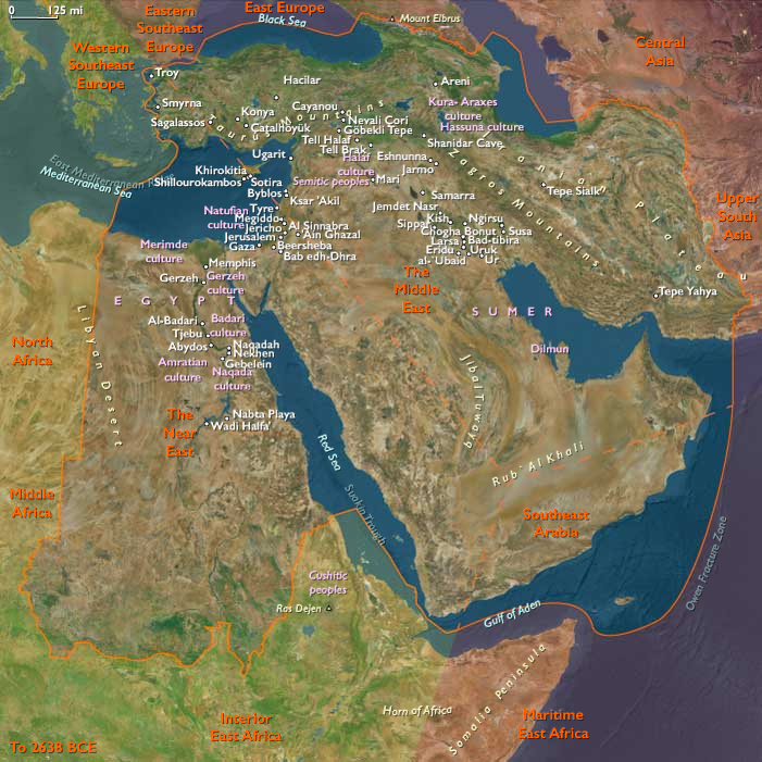
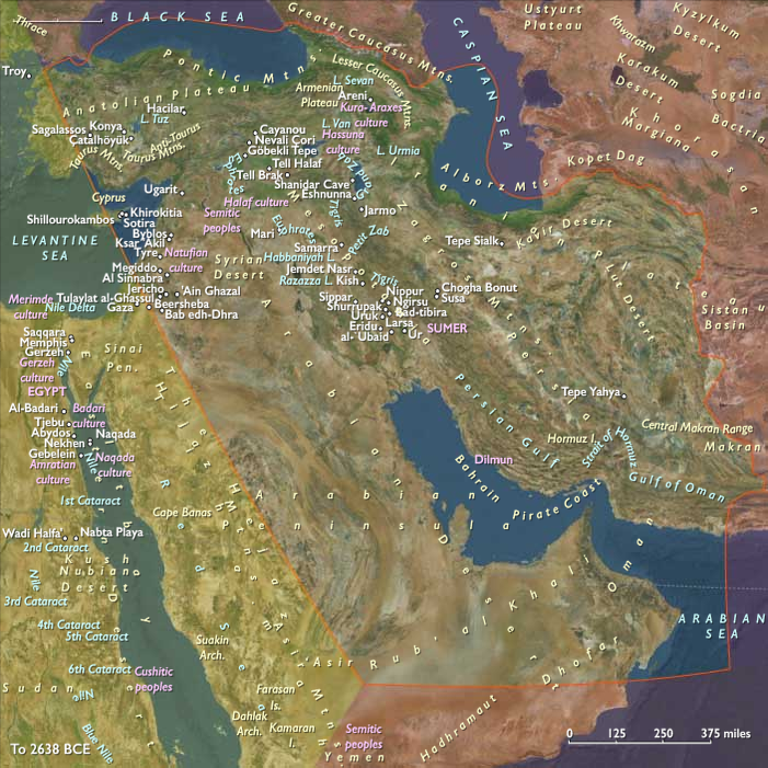
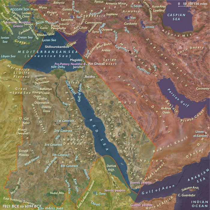
The Near and Middle East (7,821 – 6,094 BCE): Early Holocene — Springs, Marshes, and Littoral Corridors
Geographic & Environmental Context
During the Early Holocene, the Near and Middle East formed a continuous arc of water-anchored landscapes:
-
Zagros–Upper Mesopotamia and the Caucasus of the Middle East, with spring-fed piedmonts, oak woodlands, and marsh–riparian mosaics along the Tigris–Euphrates.
-
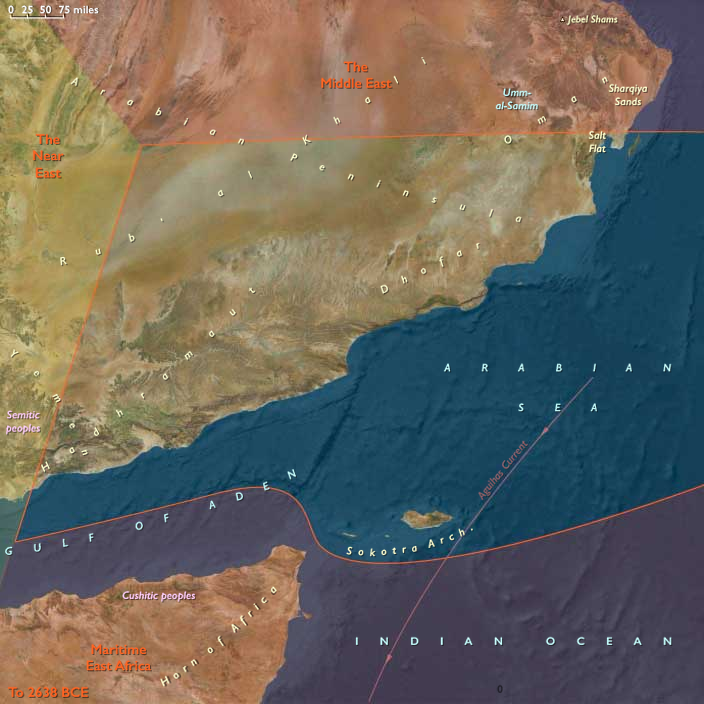
Dhofar–Hadhramaut–Mahra and Socotra in Southeast Arabia, where fog-belt escarpments and perennial wadis met lagoonal coasts.
-
The Nile Valley and Delta, the Anatolian Aegean littoral, and the Red Sea west slope in the Near East, where stabilized shorelines and floodplains framed broad-spectrum coastal economies.
Rising seas neared modern outlines; Gulf transgression continued; deltas, back-barrier lagoons, and levee lakes multiplied. Mountains, rivers, and coasts knit together a single hydrological engine.
Climate & Environment
The onset of the Holocene thermal optimum brought warmer, wetter, and more regular regimes:
-
Monsoon spillovers and westerlies greened the Zagros and Caucasus belts; springheads proliferated on piedmont fans.
-
Lower Mesopotamian backwaters expanded as the Gulf transgressed; reedbeds and marsh islets spread.
-
Nile floods strengthened, building fresh levees and fish-rich backwaters; Aegean coasts stabilized; Hejaz–Yemen slopes greened seasonally under reliable rains.
Overall, a water-positive equilibrium favored semi-sedentary residence at springs, levees, and lagoons.
Subsistence & Settlement
A broad-spectrum, semi-sedentary mosaic took hold across three spheres:
-
Middle East (Zagros–Upper Mesopotamia–Caucasus–Khuzestan/Gulf rim): small springhead and low-terrace hamlets paired seed–nut processing (acorns, wild cereals, pulses) with hunting and wetland fishing/fowling. On Zagros slopes, first caprine management emerged as wild sheep/goats were corralled near camps. Marsh communities in the Tigris–Euphrates backwaters specialized in reeds, fish, and birds.
-
Southeast Arabia (Dhofar–Hadhramaut–Mahra–Socotra): spring hamlets clustered where wadis ran year-round; littoral foragers exploited estuaries, mangroves, turtles, and shellfish; inland rounds added ibex/gazelleand fruit/nut gathering. Socotra likely saw transient seasonal use without permanent settlement.
-
Near East (Nile–Aegean–Red Sea–SW Anatolia–Yemen west): along the Nile, reed-craft villages harvested fish, mollusks, and wild cereals; on the Anatolian coasts, broad-spectrum foragers used rocky coves, shell banks, and deer ranges; Tihāma stretches witnessed episodic coastal foraging.
Settlement fabrics were nodal and reoccupied—springs, levees, dune ridges, and headlands accruing storage pits, hearths, and refuse.
Technology & Material Culture
Toolkits converged on processing, storage, and water mobility:
-
Ground-stone mortars, querns, and larger storage pits proliferated; microlithic inserts persisted in composite tools.
-
Weirs, nets, and basketry underwrote mass capture in marsh and estuary; dugouts and reed craft plied quiet channels (Nile backwaters, lagoons).
-
Incipient pottery appeared late and peripherally (northern Iranian/Caspian and Anatolian fringes), initially for boiling, fermenting, and storage.
-
Shell and stone ornaments marked persons and places; reed and timber architecture scaled from shelters to long-used house platforms.
Movement & Interaction Corridors
Water and pass systems braided the subregions:
-
Zagros passes (Kermanshah–Khuzestan) linked upland spring villages to Khuzestan plains and the Upper Gulf marshes.
-
Karkheh–Karun–Shatt al-Arab backwaters moved fish, reeds, and bitumen; Caucasus–Kura–Araxes tracks tied highland belts to Iranian forelands.
-
Dhofar–Hadhramaut–Mahra wadis funneled inland products to lagoons; short maritime hops hinted at contact toward Yemen highlands and the Horn.
-
The Nile channel–backwater network integrated levee hamlets; Aegean island-hops circulated tools and foodstuffs along western Anatolia; Red Sea shore lanes strung wadi mouths into seasonal routes.
These links created redundancy: when upland acorn or gazelle yields dipped, marsh fish and coastal shell surpluses filled the gap.
Cultural & Symbolic Expressions
House and water were the sacred axis:
-
House-based ritual (hearth offerings, ancestor interments beneath floors) and stone slab markers consolidated lineage claims to springs and terraces.
-
Ochre accompanied burials; feasting mounds rose at levees and shell terraces.
-
Rock art on desert margins (Haima, Zagros) depicted hunters, caprids, and processions; figurine precursors appeared on Aegean coasts.
Across the arc, ancestral tenure over water—the spring, the levee bend, the lagoon bar—defined community identity.
Environmental Adaptation & Resilience
Resilience rested on storage + mixed rounds + proximity to permanent water:
-
Dried fish, meat, nuts, and wild cereals buffered lean seasons; reed-work granaries/pits protected stores.
-
Mixed wetland–upland rounds (marsh in winter, piedmont in spring, highland in summer) spread risk across ecotones.
-
Caprine management on Zagros slopes and littoral–wādī flexibility in Southeast Arabia stabilized protein and fat supplies.
-
Marsh and lagoon anchoring damped climate swings, keeping calories near at hand when hunts failed or seed harvests were poor.
Long-Term Significance
By 6,094 BCE, the Near and Middle East had crystallized into a water-anchored, semi-sedentary world: spring and levee villages, marsh fisheries, lagoon coasts, and first herd management. The technological grammar of the Neolithic—grinding, storage, place fidelity, selective herd control, and limited ceramics—was already legible.
From these habits would grow the Zagros–Upper Mesopotamian cultivation/herding communities, the oasis–marsh economies of the Gulf rim, and the Nile–Aegean littoral networks—the earliest durable frameworks of Old World civilization.
Groups
Topics
Commodities
Subjects
Regions