North Polynesia (964–1107 CE): Ahupuaʻa Formation and…
964 CE to 1107 CE
North Polynesia (964–1107 CE): Ahupuaʻa Formation and the Expansion of Coastal Fishpond Landscapes
Geographic Parameters
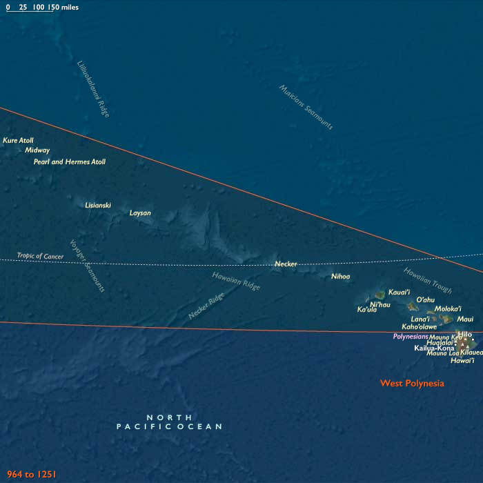
North Polynesia comprised Kauaʻi, Niʻihau, Oʻahu, Molokaʻi, Lānaʻi, Kahoʻolawe, Maui, and the Northwestern Hawaiian Islands extending through Nihoa, Mokumanamana, French Frigate Shoals, Laysan, Lisianski, Pearl and Hermes Atoll, Midway, and Kure. Hawaiʻi Island remained part of the adjoining West Polynesian subregion while continuing to participate in Hawaiian voyaging, exchange, and cultural development.
The principal high islands combined steep volcanic mountains, deeply incised valleys, perennial streams, dry leeward plains, sheltered embayments, coral reefs, and productive nearshore fisheries. Their contrasting ecological zones increasingly became components of integrated resource systems rather than separate environments.
Environmental Continuity
The environmental structure of the archipelago remained fundamentally unchanged. Windward valleys supplied dependable freshwater for irrigation, while leeward districts relied upon dryland cultivation, marine harvesting, and exchange. Extensive native forests continued to occupy upland watersheds, protecting stream flow and providing timber, fiber, birds, and other resources essential to island life.
Communities increasingly recognized that productive landscapes extended from mountain forests to offshore reefs. Forests regulated water supplies, streams nourished irrigated fields, wetlands filtered runoff, reefs sustained fisheries, and coastal lagoons supported aquaculture. This ecological continuity increasingly shaped both settlement and social organization.
Despite growing populations, the islands remained visually dominated by forests, volcanic landforms, streams, reefs, and open ocean. Human activity expanded within these systems rather than replacing them.
Settlement Development
Permanent settlement continued expanding throughout productive valleys and protected coasts. Existing communities became denser rather than dramatically larger, with new households occupying spaces between earlier family compounds. Villages remained dispersed within agricultural landscapes, separated by groves, wetlands, stream corridors, gardens, and cultivated terraces.
The greatest concentrations developed on Oʻahu, Kauaʻi, Maui, and eastern Molokaʻi, where favorable combinations of freshwater, fertile soils, and reef fisheries supported substantial population growth. Smaller islands retained lower population densities and more localized settlement patterns reflecting environmental limitations.
Rather than creating urban centers, settlement matured into continuous productive landscapes in which houses, terraces, orchards, paths, ponds, and canoe landings formed interconnected mosaics.
Formation of Ridge-to-Reef Districts
The defining historical development of this age was the emergence of increasingly integrated ridge-to-reef management systems that would later be recognized as ahupuaʻa.
Communities no longer viewed forests, valleys, agricultural lands, and fisheries as separate resources. Individual districts increasingly coordinated access to entire watersheds, linking upland forests, irrigation headwaters, cultivated valleys, coastal settlements, fishponds, reefs, and offshore fisheries into coherent economic landscapes.
Although these districts varied considerably among islands and had not yet reached the standardized form known from later centuries, their ecological logic had become well established. Families understood that maintaining forests protected streams, functioning streams sustained irrigation, healthy wetlands improved coastal fisheries, and productive reefs depended upon careful management of upland landscapes.
This represented an important organizational innovation, yet administration remained primarily local. Ecological integration preceded bureaucratic formalization.
Agricultural Intensification
Irrigated taro cultivation expanded significantly during this period. Earlier household irrigation works increasingly merged into larger valley systems connected through coordinated diversion channels and terrace networks. Neighboring communities cooperated in maintaining stream diversions, repairing terrace walls, clearing sediment, and regulating seasonal water distribution.
Stone-lined channels became more sophisticated, while terraces spread across suitable valley floors on Oʻahu, Kauaʻi, Maui, and Molokaʻi. Nevertheless, irrigation remained constrained by stream flow, topography, and available labor.
Dryland agriculture expanded simultaneously rather than declining. Sweet potato became increasingly important on leeward slopes, accompanied by dryland taro, gourds, sugarcane, bananas, coconuts, breadfruit, and household gardens. Farmers employed mulching, windbreaks, stone alignments, and crop diversification to stabilize production under variable rainfall.
The agricultural landscape therefore became more diversified instead of more specialized.
Expansion of Coastal Fishponds
The second major development of the age was the systematic expansion of coastal loko iʻa.
Earlier fish traps and small enclosures gradually evolved into larger managed fishponds protected by substantial stone walls and controlled through wooden or stone sluice gates (mākāhā). These structures encouraged juvenile fish to enter while retaining mature stocks for later harvest.
Fishponds developed primarily along sheltered coasts of Oʻahu, Molokaʻi, Maui, and Kauaʻi, where broad reef flats and protected embayments favored construction. They remained relatively uncommon on more exposed or environmentally unsuitable coastlines.
Even where fishponds expanded, they supplemented rather than replaced open-ocean fisheries. Reef fishing, offshore canoe expeditions, shellfish collection, seaweed gathering, and estuarine harvesting continued to provide much of the archipelago's marine food.
The combined system of reefs, fishponds, streams, and cultivated valleys created one of the Pacific's most productive agro-marine economies.
Economic Organization
Households remained the foundation of production, but increasing surpluses supported greater occupational specialization. Skilled canoe builders, navigators, irrigation experts, fishpond managers, net makers, woodworkers, featherworkers, and ritual specialists became more prominent within island societies.
Exchange between districts intensified. Salt from leeward flats, preserved fish, barkcloth, basalt tools, canoe timber, feathers, cordage, mats, and agricultural products circulated regularly among neighboring islands.
Redistribution increasingly occurred through emerging chiefly households that organized communal labor for irrigation maintenance, fishpond construction, and ceremonial gatherings. Nevertheless, productive landscapes—not chiefly compounds—remained the visual and economic center of Hawaiian life.
Movement and Maritime Networks
Interisland voyaging reached a high level of routine organization. Regular canoe routes linked Kauaʻi and Niʻihau; Oʻahu with Molokaʻi, Lānaʻi, and Maui; and continued onward to Hawaiʻi Island.
Navigators refined their understanding of swells, currents, winds, stars, cloud formations, and seabird behavior. Canoes transported food surpluses, construction materials, ritual objects, marriage partners, skilled specialists, and political messengers.
The Northwestern Hawaiian Islands remained environmentally significant but peripheral to ordinary settlement. Occasional expeditions visited nearer islands for birds, feathers, fishing, and ritual purposes, while Midway and the far northwestern atolls continued without permanent occupation.
Institutions and Sacred Landscapes
As productive landscapes expanded, ritual institutions also became more formalized. Agricultural shrines, fishing shrines, springs, headwaters, prominent rocks, and coastal ceremonial places increasingly linked spiritual practice to ecological management.
The kapu system became more systematic in regulating access to fisheries, irrigation water, forests, and cultivated lands. Seasonal restrictions protected spawning fish, controlled harvest timing, and reinforced chiefly authority through ecological stewardship.
Small and medium-sized heiau became more common across productive districts, serving agricultural, healing, fishing, and lineage functions. Monumental temple construction, however, remained limited and did not dominate the landscape.
Religious authority continued to emerge from productive environments rather than replacing them.
Political Development
Chiefly authority expanded gradually as larger productive districts required greater coordination. Senior aliʻiincreasingly supervised irrigation systems, fishpond maintenance, dispute resolution, ceremonial redistribution, and communal labor.
Political organization remained multipolar. Oʻahu, Kauaʻi, Maui, and Molokaʻi each contained numerous competing chiefly districts whose influence fluctuated through alliance, marriage, ritual prestige, and occasional warfare.
No island yet exercised lasting dominance over the others. Ecological management remained more important than territorial conquest in determining long-term prosperity.
Adaptation and Resilience
North Polynesian resilience rested upon diversification rather than specialization. Irrigated valleys, dryland fields, fishponds, reefs, forests, orchards, wetlands, and interisland exchange together buffered communities against drought, storms, flooding, and localized crop failures.
Communal labor maintained irrigation channels, terrace walls, fishpond embankments, canoe fleets, and forest trails. The growing integration of ridge-to-reef districts allowed environmental stresses affecting one part of a watershed to be addressed through coordinated management of the entire landscape.
This ecological integration represented one of the most sophisticated adaptive systems in the prehistoric Pacific.
Legacy of the Age
Between 964 and 1107 CE, North Polynesia underwent its first major landscape-wide organizational transformation. Permanent settlements expanded into increasingly integrated ridge-to-reef districts, while irrigated taro valleys and coastal fishponds became complementary elements of a unified agro-marine economy.
Rather than creating centralized states, these developments strengthened ecological coordination among households, lineages, and emerging chiefly communities. Productive landscapes became more interconnected, labor more cooperative, and resource management more sophisticated, establishing the durable ahupuaʻa framework upon which later Hawaiian chiefdoms, ritual institutions, and island polities would be built.
Images

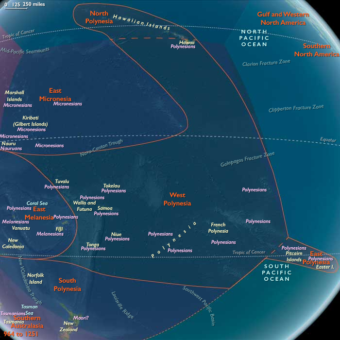
North Polynesia in the High Medieval (Lower) age
Groups
Regions
Polynesia
View →Subregions