The Royal Proclamation of 1763 is issued…
August 1763 CE
It renders worthless land grants given by the British government to Americans who had fought for the crown against France.
The Proclamation angers American colonists who want to continue their westward expansion into new farm lands and want to keep their control of local government.
The Royal Proclamation continues to be of legal importance to First Nations in Canada.
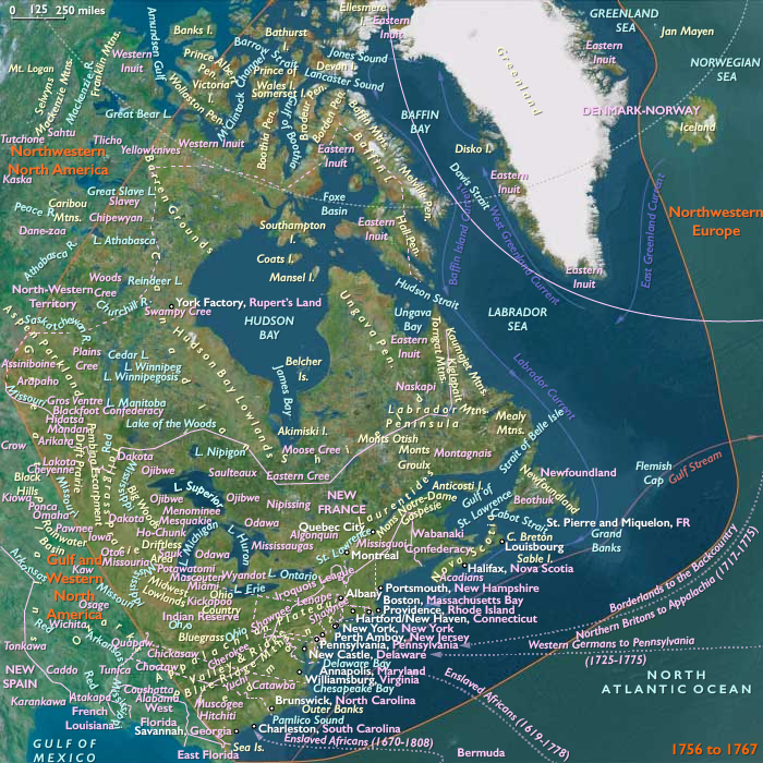
The 1763 proclamation line is similar to the Eastern Continental Divide's path running northwards from Georgia to the Pennsylvania–New York border, and north-eastwards past the drainage divide on the St. Lawrence Divide from there northwards through New England.
At the outset, the Royal Proclamation of 1763 defines the jurisdictional limits of the conquered territory.
Out of what had been the Canada colony of New France, a diminutive new colony, the Province of Quebec, is carved.
The territory northeast of the St. John River on the Labrador coast is placed under the Newfoundland Colony.
The lands west of Quebec and west of a line running along the crest of the Allegheny mountains become Indian territory, temporarily barred to settlement, to the great disappointment of the land speculators of Virginia and Pennsylvania, who had started the Seven Years' War to gain these territories.
The proclamation creates a boundary line (often called the proclamation line) between the British colonies on the Atlantic coast and native lands (called the Indian Reserve) west of the Appalachian Mountains.
The proclamation line is not intended to be a permanent boundary between the colonists and Aboriginal lands, but rather a temporary boundary that can be extended further west in an orderly, lawful manner.
It is also not designed as an uncrossable boundary; people can cross the line, just not settle past it.
Its contour is defined by the headwaters that form he watershed along the Appalachians.
All land with rivers that flow into the Atlantic is designated for the colonial entities, while all the land with rivers that flow into the Mississippi is reserved for the native population.
The proclamation outlaws the private purchase of native land, which had often created problems in the past.
Instead, all future land purchases are to be made by Crown officials "at some public Meeting or Assembly of the said Indians".
Furthermore, British colonials are forbidden to settle on native lands, and colonial officials are forbidden to grant ground or lands without royal approval.
The proclamation gives the Crown a monopoly on all future land purchases from natives.
British colonists and land speculators object to the proclamation boundary since the British government had already assigned land grants to them.
Many settlements already exist beyond the proclamation line, some of which are temporarily evacuated during Pontiac's War, and there are many already granted land claims yet to be settled.
For example, George Washington and his Virginia soldiers had been granted lands past the boundary.
Prominent American colonials join with the land speculators in Britain to lobby the government to move the line further west.
Their efforts will be successful, and the boundary line will be adjusted in a series of treaties with the natives.
Groups
Iroquois (Haudenosaunee, also known as the League of Peace and Power, Five Nations, or Six Nations)
View →
Wyandot, or Wendat, or Huron people (Amerind tribe)
View →
Miami (Amerind tribe)
View →
Lenape or Lenni-Lenape (later named Delaware Indians by Europeans)
View →
Ojibwa, or Ojibwe, aka or Chippewa (Amerind tribe)
View →
Odawa, or Ottawa, people (Amerind tribe)
View →
Seneca (Amerind tribe)
View →
Mascouten (Amerind tribe)
View →
Kickapoo people (Amerind tribe)
View →
Potawatomi (Amerind tribe)
View →
Wea (Amerind tribe)
View →
Piankeshaw (Amerind tribe)
View →
Shawnees, or Shawanos (Amerind tribe)
View →
Ohio Country
View →
Illinois Country
View →
Britain, Kingdom of Great
View →
Mingo (Seneca-Cayuga Tribe of Oklahoma)
View →
Topics
Commodities
Subjects
Regions
Northern North America
View →Subregions