West Polynesia (2,637 – 910 BCE): Proto-Settlement…
2637 BCE to 910 BCE
West Polynesia (2,637 – 910 BCE): Proto-Settlement Horizons — Lapita Approaches and First Colonizations (Tonga–Samoa)
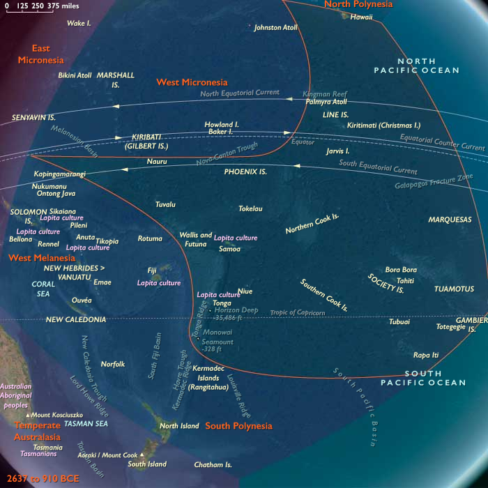
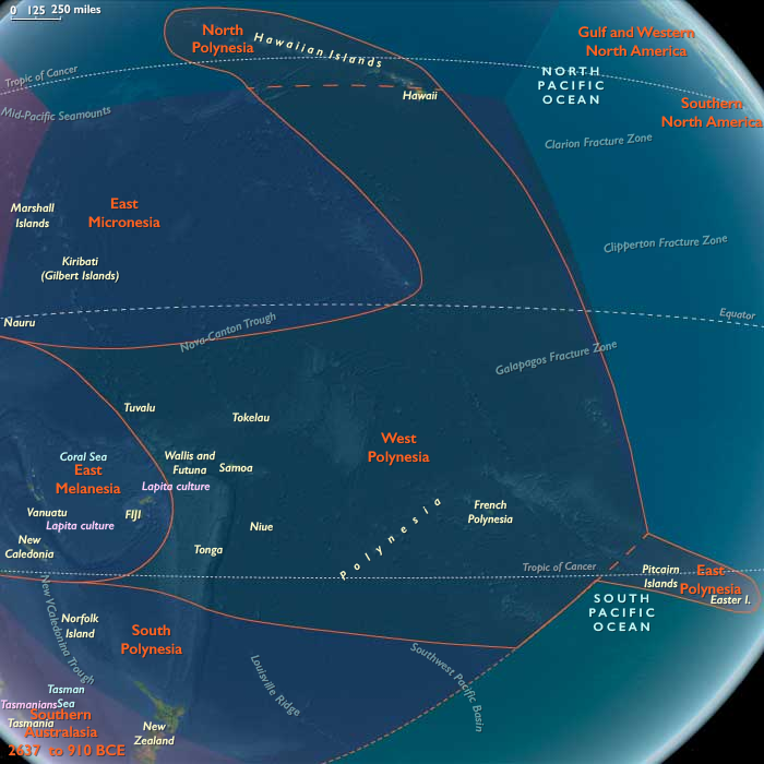
Geographic & Environmental Context
West Polynesia includes Hawaiʻi Island (the Big Island); Tonga (Tongatapu, Haʻapai, Vavaʻu); Samoa (Savaiʻi, Upolu, Tutuila/Manuʻa); Tuvalu and Tokelau (low atolls); the Cook Islands (Rarotonga, Aitutaki, Mangaia, etc.); Society Islands (Raiatea–Tahiti–Moʻorea–Bora Bora); and the Marquesas (Nuku Hiva, Hiva Oa).
-
Anchors (settlement focus): Tongatapu–Haʻapai–Vavaʻu (Tonga), Savaiʻi–Upolu (Samoa); Society Islands–Marquesas–Cooks–Hawaiʻi Island remain unsettled; Tuvalu–Tokelau likely unsettled or only intermittently visited at the end of this span.
Climate & Environmental Shifts
-
Holocene stability with episodic droughts; lagoons and leeward plains productive; reliable trade winds support long-range sailing.
Subsistence & Settlement
-
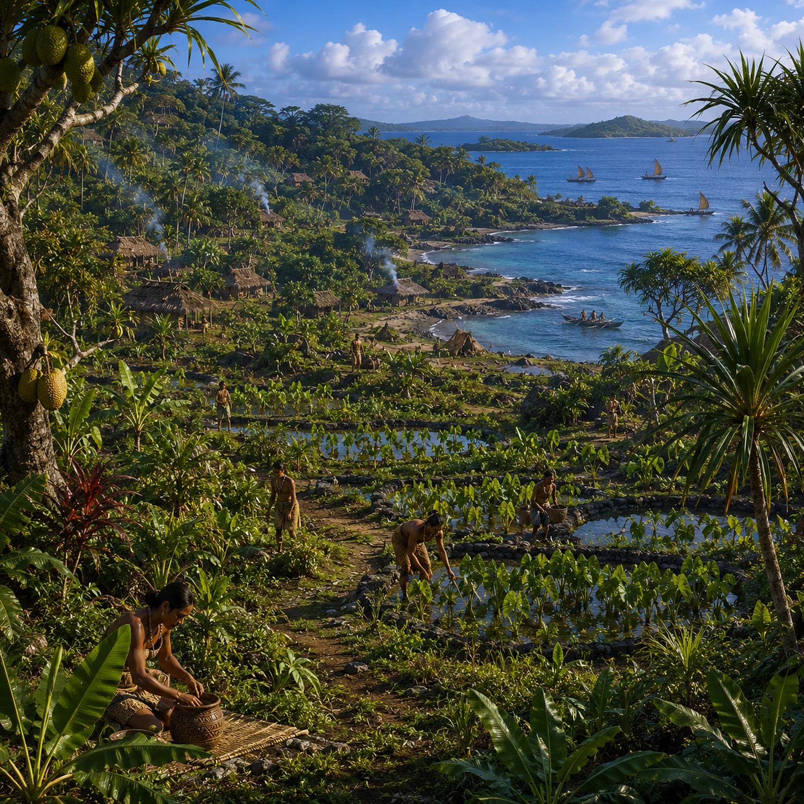
Lapita voyagers (c. 900–800 BCE) colonize Tonga and Samoa: establish coastal hamlets on leeward flats and bay heads.
-
Horticulture: taro, yam, banana, breadfruit; arboriculture (pandanus, coconut) planted; managed fallows.
Technology & Material Culture
-
Lapita dentate-stamped ceramics, obsidian and high-quality cherts, one- and double-hulled canoes (waʻa), shell adzes, drilled pearlshell fishhooks, barkcloth (tapa).
Movement & Interaction Corridors
-
Backbone route: Fiji–Tonga–Samoa; exploratory probes reach Cooks and Societies late in the epoch (no firm permanent settlement); Marquesas and Hawaiʻi Island remain beyond routine circuits.
Cultural & Symbolic Expressions
-
Lapita ancestral iconography on pottery; early marae/ahu-like ritual precincts on beach ridges inferred from alignments.
Environmental Adaptation & Resilience
-
Transported landscapes: portable cultigens, commensals (dogs, pigs, chickens), and agroforestry mosaics engineered for resilience; shoreline hamlets adopt storm-avoidance siting.
Transition
By ~910 BCE, Tonga and Samoa are settled Lapita frontiers; farther east and north (Cooks, Societies, Marquesas, Hawaiʻi Island), the ecological stage remains pristine, awaiting later pulses.
Groups
Subjects
Regions
Polynesia
View →Subregions
West Polynesia
View →Related Events
No active filters.
Showing 10 events out of 68562 total
We begin in the easternmost subregions and move westwardly around the globe, crossing the equator as many as six times to explore ever shorter time periods as we continue to circle the planet. The maps of the regions and subregions change to reflect the appropriate time period.
Narrow results by searching for a word or selecting from one or more of a dozen filters.
Its origins seem to be in the Lena river basin of Yakutia, and also along the Yenisei river; individual sites will also be found in Taymyr.
From there it spreads both to the east and to the west.
Northeastern Eurasia (2637 – 910 BCE): Bronze and Early Iron — Steppe, Forest, and Sea Corridors of the North
Regional Overview
Stretching from the Carpathian steppes to the Amur River and Okhotsk coast, Northeastern Eurasia formed one of the great connective tissues of the ancient world.
It was a realm where bronze, horses, and furs flowed between the Eurasian heartlands and the Pacific Rim.
Across its vastness, riverine farming villages, pastoral nomads, and maritime foragers forged adaptive systems that endured millennia of climatic and cultural change.
Geography and Environment
Northeastern Eurasia comprised three immense cultural landscapes:
-
the steppe–forest–river corridor of East Europe,
-
the mountain–basin–taiga arc of Northwest Asia, and
-
the riverine–maritime frontier of Northeast Asia.
From the Black and Caspian seas to the Pacific, the region spanned temperate forests, arid grasslands, and subarctic coasts.
Major waterways—the Dniester, Volga, Ob, Yenisei, and Amur—served as continental highways, uniting inland producers with distant trade spheres.
Climate and Environmental Shifts
After 2600 BCE, gradual cooling tempered the mid-Holocene warmth.
Aridity cycles reshaped steppe ecology, encouraging mobility, while northern forests and salmon rivers remained stable.
Periodic droughts on the southern plains were balanced by resource-rich rivers and coasts farther north, allowing the region to function as an interconnected ecological mosaic.
Societies and Political Developments
East Europe – Forest–Steppe Gateways
Here, mixed farmers and herders shared the landscape with mobile steppe nomads.
The Catacomb and later Srubnaya cultures built kurgan mounds and timbered graves, developing chariotry and equestrian prestige.
Northern forest peoples pursued hunting, trapping, and fishing while trading furs and amber downriver.
The great river valleys—Dnieper, Don, and Volga—became arteries of a transcontinental economy linking the Baltic, Black Sea, and Caspian worlds.
Northwest Asia – Steppe Nomads and Metallurgists
The Andronovo and Karasuk cultures of the Altai–Yenisei region perfected pastoral nomadism and bronze metallurgy.
Horse herding, dairy use, and wheeled vehicles expanded mobility across Western Siberia’s open plains.
Petroglyphs of riders, chariots, and solar emblems testify to a cosmology centered on the sun, sky, and movement.
Taiga foragers and herders exchanged furs and fish for metals, linking steppe caravans with Arctic rivers.
Northeast Asia – River Chiefs and Maritime Foragers
Along the Amur–Ussuri system and Okhotsk coast, salmon-based chiefdoms controlled fisheries and trade in furs, oils, and metals.
Small quantities of bronze and iron filtered in via Manchuria and Korea, while local economies remained rooted in fishing, hunting, and limited horticulture.
On Hokkaidō, Epi-Jōmon cultures maintained complex foraging traditions, blending marine resources with emerging agricultural knowledge.
By the end of the period, lineages of riverine leaders managed alliances and ceremonial feasts, precursors to the Okhotsk and Satsumon societies.
Economy and Technology
-
Agriculture and Herding: Mixed grain cultivation and livestock herding characterized steppe and forest-steppe zones; pastoral nomads relied on horses, cattle, and sheep, while northern groups emphasized fish, game, and reindeer.
-
Metallurgy: Bronze dominated the toolkit—axes, daggers, ornaments; iron appeared only near the close of the epoch.
-
Mobility: Wagons, chariots, skin boats, and sledges made this one of the most mobile regions of the ancient world.
-
Trade: Amber, furs, wool, horses, and metals crossed from Europe to Asia; tin and jade moved westward; long rivers bound inland communities to coastal trade.
Cultural and Symbolic Expressions
Across Northeastern Eurasia, ritual landscapes reflected a shared reverence for ancestors, animals, and the sun.
-
Steppe kurgans enshrined warriors and chieftains beneath earthen mounds.
-
Taiga and Amur villages offered fish, weapons, and carved idols in riverbanks and wetlands.
-
Rock art portrayed hunters, charioteers, solar disks, and ships, blending ecological observation with spiritual cosmology.
-
Feasting and gift exchange affirmed alliances across the vast ecological frontier.
Environmental Adaptation and Resilience
Mobility was the key to survival.
Nomads tracked pastures; fishermen followed salmon runs; foragers shifted with game migrations.
Diversified economies—grain, herds, fish, and furs—buffered communities against drought or freeze.
Storage pits, smoked fish, and dried meat ensured winter security, while interregional exchange redistributed surpluses.
Regional Synthesis and Long-Term Significance
By 910 BCE, Northeastern Eurasia was a continent-spanning web of pastoral, agrarian, and maritime societies.
Its steppe corridors funneled innovations—horse riding, chariots, metallurgy—between Europe and East Asia.
Its riverine and coastal frontiers sustained rich fisheries and trade nodes that would feed into later Silk Road systems.
The fusion of mobility, metallurgy, and environmental adaptability forged one of humanity’s most enduring cultural ecologies—a dynamic northern realm bridging the forests of Europe, the deserts of Central Asia, and the seas of the Pacific Rim.
Northeast Asia (2,637 – 910 BCE): Metal Frontiers, River Chiefs, and Epi-Jōmon Persistence
Geographic and Environmental Context
Northeast Asia includes eastern Siberia east of the Lena River to the Pacific, the Russian Far East (excluding the southern Primorsky/Vladivostok corner), northern Hokkaidō (above its southwestern peninsula), and extreme northeastern Heilongjiang.
-
Anchors: Lower Amur chiefdom nodes, Ussuri tributaries, Sakhalin north–south corridor, Okhotsk shore villages, northern Hokkaidō (Epi-Jōmon).
Divergent Paths: Siberia and the Americas
By this period, the genetic separation was complete. Native American populations, descended from a subset of Paleo-Siberians that had crossed Beringia earlier, underwent rapid demographic expansion across the Americas.
This expansion involved:
-
Strong founder effects
-
Regional isolation
-
Ecological adaptation across diverse environments
Over millennia, these processes produced wide phenotypic diversity among Indigenous American populations—entirely consistent with long-term evolutionary dynamics and independent development.
Meanwhile, Siberia itself continued to receive new population influxes from East Asia, further distancing modern Siberians from their Paleo-Siberian predecessors.
Climate & Environmental Shifts
-
Gradual cooling from mid-2nd millennium BCE; salmon cycles remained productive with occasional failures.
Subsistence & Settlement
-
Riverine chiefdoms intensified control of salmon stations; multi-house compounds with storage pits.
-
Hokkaidō Epi-Jōmon maintained broad-spectrum foraging with pottery and shell middens; limited horticulture at southern margins late in the period.
Technology & Material Culture
-
Bronze and iron trickled in via Amur–Sungari–Koryo networks: small knives, ornaments; local tools still stone/bone/antler.
-
Sinew-backed bows; dogs for hauling; winter oil lamps and skin boats on the Okhotsk coast.
Movement & Interaction Corridors
-
Amur–Sungari metal/horse trade; Sakhalin as bridge between mainland and Hokkaidō; coastal couriers along Okhotsk.
Cultural & Symbolic Expressions
-
Chiefly feasts anchored diplomatic networks; bear and salmon rites continued; formalized cemetery rows reflect lineage memory.
Environmental Adaptation & Resilience
-
Exchange-for-metal strategies augmented cutting and sewing efficiency; storage + mobility buffered salmon shortfalls.
Transition
On the eve of the 1st millennium BCE, river chiefs and coastal specialists stood poised to integrate novel tools and alliances that would culminate in later Okhotsk and Satsumon horizons.
Western Branches of the Arctic Small-Tool Tradition
West of 110°W, Arctic Small-Tool groups spread across Alaska, the western Canadian Arctic, and the Bering Strait corridor. Like their eastern counterparts, they mastered microlithic technology and portable shelters, but local adaptations emphasized both inland and coastal hunting.
In Alaska, small-blade toolkits supported mixed economies: caribou, fish, and seals along coastal margins. Seasonal mobility linked river valleys to sea ice. These ASTt communities set the stage for later Choris, Norton, and Ipiutak traditions, and ultimately the florescence of the Old Bering Sea culture.
By 910 BCE, the foundations of western Arctic lifeways—flexibility, mobility, and cross-Strait connections—were firmly in place.
Northern North America (2637 – 910 BCE): Copper and Slate, Salmon and Earthworks — Coast, River, and Desert Worlds
Regional Overview
From the Arctic sea-ice and salmon-flooded fjords of the North Pacific to the Great Lakes–Ohio valleys and the estuaries and deserts of the Gulf and West, Early Antiquity in Northern North America was defined by mobility, storage, and exchange.
Three great cultural theaters cohered without empire:
-
the Northwest, where ASTt bands in the Arctic coexisted with ranked plank-house polities on the Pacific coast;
-
the Northeast, where Woodland earthwork traditions and diversified river–coastal economies matured;
-
the Gulf & West, where estuaries, deserts, and Pacific littorals linked seasonal camps into wide resource webs.
Together they formed a continent-spanning mosaic of specialized ecologies joined by grease trails, canoe corridors, and reciprocity.
Geography & Environment
-
Northwest: Arctic Alaska’s Kotzebue–Norton coasts, Brooks Range interior, Cook Inlet–Prince William Sound, Haida Gwaii–Central Coast, and the Fraser–Columbia plateaus.
-
Northeast: Atlantic façade from Florida to Newfoundland, St. Lawrence–Great Lakes–Ohio–Mississippivalleys, Appalachian uplands, Hudson Bay rim, and the Eastern Arctic/Greenland margins.
-
Gulf & West: Gulf wetlands and estuaries, Colorado and Central California valleys, Sonoran–Mojave deserts, and southern Rockies/Sierra piedmonts.
Environmental contrasts—ice-edge seas, temperate rainforests, prairie-woodland ecotones, and dune–playa basins—drove seasonal movement and regional specialization.
Climate & Environmental Shifts
Gradual late-Holocene cooling touched all three spheres.
-
Arctic sea-ice regimes structured hunting windows but salmon runs stayed reliable.
-
Northeastern woodlands stabilized around lake–river systems; coastal storms and estuarine productivity persisted.
-
Gulf & West oscillated between wetland surges and desert drought pulses; Pacific upwelling anchored fisheries.
Across the region, storage, multi-ecozone mobility, and trade redundancy were the principal buffers against climate variability.
Societies & Settlement
Northwest
-
Arctic Small Tool tradition (c. 2500–800 BCE): microblade toolkits, small semi-subterranean houses, high mobility—precursors to later Paleo-Inuit/Thule systems.
-
North Pacific Coast: ranked household polities in massive cedar plank dwellings controlled salmon weirs, canoe landings, and cedar stands; interior pit-house towns flourished along salmon canyons (Fraser/Columbia).
Northeast
-
Early–Middle Woodland trajectories seeded by Late Archaic: Adena → Hopewell earthwork ceremonialism in the Ohio and allied river valleys; dense fisheries around the Great Lakes; shell-heap villages along the Atlantic.
-
Horticulture expanded; maize diffusion began in the Midwest late in the span, complementing riverine stored foods.
Gulf & West
-
Gulf Coast: shellfish- and fish-rich estuaries supported large middens and seasonal mound sites.
-
Arid Southwest/Great Basin: early cultivation (squash, sunflower) complemented foraging; water storage and mobility were key.
-
California: acorn economies, salmon fisheries, and Channel Islands–coast exchange linked beadwork, fish products, and obsidian.
Economy & Technology
-
Metals: No bronze/iron industries; native copper cold-hammered in the Northwest and Northeast (Great Lakes copper sheets, NW Alaska awls/points).
-
Lithics: Ground slate knives and points proliferated on the North Pacific; obsidian (Edziza) traveled inland; widespread projectile point traditions persisted.
-
Boats: Skin boats and lamps in the Arctic; sewn-plank and dugout canoes on coasts and inland rivers; estuarine canoes in the Gulf and California.
-
Food systems: smoking/drying racks, plank or pit granaries, and earth ovens generalized food storage across regions—the continent’s key resilience technology.
Movement & Interaction Corridors
-
Grease trails carried eulachon oil from coastal inlets to interior plateau towns; copper, slate, and labret styles circulated along the Gulf of Alaska.
-
Hopewell Interaction Sphere moved mica, obsidian, copper, marine shell among the Great Lakes–Ohio–Appalachian networks; coastal canoe routes linked Chesapeake–Delaware–Hudson–Gulf of Maine.
-
Gulf & Pacific corridors joined estuaries to deserts and islands: shell beads, fish products, pigments, and lithics moved between California, the Channel Islands, and interior valleys; along the Gulf, canoe coasting tied river mouths into a common littoral.
Belief & Symbolism
-
Northwest: first-salmon rites, sea-mammal ceremonies, and emergent crest/lineage identifiers in house art and grave goods.
-
Northeast: earthwork cosmology—Adena/Hopewell mounds with astronomical alignments; carved pipes, copper sheets, and mica mirrors in mortuary assemblages.
-
Gulf & West: shell ornaments, petroglyphs, and painted shelters; coastal and desert ritual emphasized water, game, and ancestral places.
Across regions, feasting, exchange, and mortuary offerings cemented alliances and stabilized resource sharing.
Environmental Adaptation & Resilience
-
Arctic & Subarctic: ice-edge scheduling + salmon storage; driftwood logistics; multi-habitat seasonal rounds.
-
North Pacific Coast: ranked redistribution and stored salmon/eulachon oil smoothed shocks.
-
Northeast: diversified woodland subsistence and inter-regional alliances buffered failure.
-
Gulf & West: mobility between estuary, valley, and upland; water caching and drought-tolerant foraging; smoked/dried surplus against hurricanes and dry years.
Storage + mobility + exchange formed a continent-wide triad of resilience.
Regional Synthesis & Long-Term Significance
By 910 BCE, Northern North America had matured into a tripartite cultural mosaic:
-
Arctic ASTt traditions set the stage for Paleo-Inuit and Thule expansions;
-
North Pacific ranked house societies and interior salmon towns approached their classic florescence;
-
Woodland earthwork networks in the Northeast deepened, while Gulf & Western ecologies sustained diverse, specialized lifeways.
Copper and slate innovation, canoe corridors, and ritualized exchange bound these worlds together—a continental infrastructure of knowledge and movement that would support the medieval transformations described in later-epoch chapters.
Northwestern North America (2,637 – 910 BCE) Metal Elsewhere, Copper & Slate Here — ASTt in the Arctic, Ranked Households on the Coast
Geographic and Environmental Context
Northwestern North America includes Alaska, western Canada (Alberta, British Columbia, Yukon and Northwest territory and Nunavut west of 110°W) Alaska, Washington State, northern Idaho, and the northwestern portions of Montana, Oregon, and California.
-
Anchors: Western Arctic Alaska (Kotzebue Sound–Norton Sound), Brooks Range, Cook Inlet–Prince William Sound, Haida Gwaii–Central Coast, Fraser–Columbia plateaus.
Climate & Environmental Shifts
-
Gradual cooling; reliable salmon cycles continued; sea-ice dynamics shaped Arctic foraging.
Subsistence & Settlement
-
In the western Arctic, the Arctic Small Tool tradition (ASTt) (c. 2500–800 BCE) established small, mobile camps with microblades and finely made points—precursors to later Paleo-Inuit and Thule systems.
-
Along the North Pacific Coast, ranked households with large plank dwellings consolidated control of weirs, canoe landings, and cedar groves; interior pit-house towns persisted.
Technology & Material Culture
-
Native copper (NW Alaska/Interior) cold-hammered into awls, points; ground slate knives/weapons proliferated on coasts.
-
Oil lamps, skin-covered boats in Arctic; heavy carpentry tools on coasts; labrets appear variably around Gulf of Alaska contexts.
Movement & Interaction Corridors
-
Grease trails (eulachon oil) from inlets to interior; obsidian (Edziza) widely traded; Arctic driftwood routes supplied interior treelines.
Cultural & Symbolic Expressions
-
Salmon and sea-mammal rituals matured; clan or crest-like identifiers emerged in house art and grave goods in some coastal zones.
Environmental Adaptation & Resilience
-
Storage economies plus multi-ecozone mobility buffered climatic variability; copper/slate innovations improved cutting and sewing in wet–cold conditions.
Transition
On the eve of the 1st millennium BCE, the region juxtaposed mobile Arctic microlithic traditions with coastal ranked house societies and interior villages bound by grease and obsidian trails.
Polynesia (2637 – 910 BCE): Lapita Horizons, Voyaging Science, and the Unreached North
Regional Overview
Across the open Pacific, Polynesia lay poised for its first true colonization.
While the great civilizations of Eurasia turned to bronze, iron, and empire, this oceanic world entered an age of exploration defined not by metals but by canoes, stars, and memory.
Between the mid-third and early first millennium BCE, Austronesian voyagers—descendants of Lapita pioneers—pushed eastward from the Bismarck and Fijian arcs, testing routes that would one day span a third of the globe.
The southern frontier, in Tonga and Samoa, saw permanent settlement by about 900 BCE.
Farther east and north, the Societies, Marquesas, Hawaiʻi, and Rapa Nui remained pristine: mapped in mind, not yet in habitation.
Geography and Environmental Context
The Polynesian triangle—bounded by future Hawaiʻi, New Zealand, and Rapa Nui—was still largely empty of people.
To the south and west, Lapita societies thrived along the Fiji–Tonga–Samoa axis, a zone of fertile volcanic soils, reef-sheltered coasts, and abundant breadfruit and taro.
Northward stretched the high, forested islands of the Hawaiian chain and the remote atoll of Midway; eastward, the volcanic peaks of the Societies and Marquesas, the coral ridges of the Cooks, and the lonely cones of Rapa Nui and Pitcairn awaited discovery.
Across these immense distances, the Pacific’s trade winds, countercurrents, and celestial regularities provided the framework for navigation.
Climate and Environmental Shifts
Holocene stability reigned.
Regular trade-wind seasons, interspersed with localized droughts and Kona-type storms, defined the pattern familiar through later millennia.
Sea levels had stabilized close to modern elevations, lagoons and atolls matured ecologically, and coral reef systems reached their pre-human equilibrium—a pristine baseline soon to host the transported landscapes of Polynesian horticulture.
Societies, Settlement, and Expansion
By the early first millennium BCE, Lapita communities from Near Oceania had developed into full maritime chiefdoms.
They founded Tonga and Samoa, bringing with them domesticated animals, tubers, tree crops, and an integrated horticultural–fishing economy.
Their settlements, organized around coastal hamlets and beach-ridge cemeteries, formed the first enduring societies in what would become Polynesia proper.
These colonists combined intricate kinship systems with lineage-based authority expressed through exchange and feasting.
Beyond them, the high islands and atolls of central and northern Polynesia remained unvisited—the last great frontier of the human voyage.
Economy and Technology
Lapita subsistence depended on mixed horticulture, arboriculture, and reef harvesting.
Stone and shell adzes, barkcloth looms, and obsidian tools underpinned daily life.
Pottery—characterized by its distinctive dentate-stamped designs—served as both utilitarian ware and a marker of cultural identity.
The real technological revolution, however, lay in seamanship: the refinement of the double-hulled canoe, the balanced crab-claw sail, and the astronomical navigation system that made deliberate ocean crossings routine.
These innovations transformed the Pacific from a barrier into a continent of water.
Movement and Interaction Corridors
A dense voyaging corridor linked Fiji, Tonga, and Samoa, forming the nucleus of the later Polynesian exchange sphere.
Exploratory probes reached eastward toward the Cook and Society Islands and northward into uncharted waters, where Hawaiʻi’s volcanic silhouettes awaited future landfall.
Each expedition tested wind patterns, star paths, and ocean swells, gradually extending the mental map of the ocean.
The Lapita maritime network thus became the laboratory from which Polynesian wayfinding emerged.
Belief and Symbolism
Lapita iconography—incised faces, spirals, and concentric motifs—encoded ancestral and cosmological themes, linking the sea, lineage, and creation.
Sacred beach terraces, aligned to the horizon, may represent early forms of marae or ahu, foreshadowing the ritual architecture of later Polynesia.
Voyaging itself was a sacred act: canoes were consecrated, navigators initiated, and landfalls interpreted as fulfillments of ancestral design.
Environmental Adaptation and Resilience
Colonists transported a complete biocultural package—taro, yam, breadfruit, coconut, pig, dog, chicken, and the social institutions to manage them.
They sited villages in leeward zones sheltered from cyclones, practiced intercropping for soil stability, and established portable ecosystems that could regenerate on any new island.
In yet-unsettled regions, natural ecosystems continued undisturbed, providing the environmental blank slate that later settlers would transform into productive landscapes.
Regional Synthesis and Long-Term Significance
By 910 BCE, Tonga and Samoa stood as the Lapita world’s eastern bastions, while the vast remainder of Polynesia remained silent and untouched.
Yet every element of the later Polynesian achievement was already in place—the technology, cosmology, and navigational genius that would soon knit the central and northern Pacific into a single cultural sphere.
This epoch thus represents Polynesia in potential: a constellation of islands awaiting connection, its human story poised at the threshold of discovery.
North Polynesia (2,637–910 BCE): The Unreached Volcanic Archipelago
Geographic and Environmental Context
North Polynesia encompasses the Hawaiian Archipelago, including the high volcanic islands of Hawaiʻi, Maui Nui, Oʻahu, Kauaʻi, Molokaʻi, Lānaʻi, Kahoʻolawe, Niʻihau, and the smaller islands and atolls extending northwestward toward Midway.
Anchors: Hawaiʻi Island volcanoes, Maui Nui remnants, windward rainforest valleys, leeward dry coasts, Northwestern Hawaiian atolls, Midway.
Climate & Environmental Shifts
Holocene climatic stability persisted across the central North Pacific.
Trade winds delivered predictable rainfall to windward slopes, supporting extensive native forests of ʻōhiʻa, koa, loulu palms, and diverse understory communities. Leeward coasts remained seasonally dry, while summit environments hosted alpine and subalpine ecosystems unique within Polynesia.
Coral reefs, lagoons, seabird colonies, and nearshore fisheries functioned in equilibrium, unaffected by human exploitation.
Ecology & Landscape Systems
The Hawaiian chain represented one of the most isolated large archipelagos on Earth.
Its ecosystems were characterized by:
- extensive seabird nesting grounds
- intact coastal strand communities
- native forest canopies extending from shoreline to uplands
- freshwater stream systems descending from volcanic interiors
- reef–lagoon–open ocean ecological integration
Large colonies of albatrosses, petrels, shearwaters, terns, and other seabirds transported marine nutrients inland, creating strong links between oceanic and terrestrial ecosystems.
Human Presence
No permanent human settlement existed.
Although Lapita-descended navigators were establishing societies in Tonga and Samoa, Hawaiʻi remained beyond the eastern and northern frontier of regular voyaging.
The islands were therefore among the largest habitable landmasses on Earth still untouched by human occupation.
No agriculture, villages, domestic animals, landscape burning, or introduced species had yet altered the environment.
Maritime Context
The Hawaiian Islands occupied a critical position within the emerging mental geography of Polynesian exploration.
Although likely unknown in direct experience to most Lapita communities, the wind systems, currents, and celestial pathways that would eventually connect Hawaiʻi to the broader Polynesian world were already operating in recognizable form.
The archipelago thus existed as a future destination embedded within the navigational possibilities of the Pacific rather than within its settled geography.
Environmental Adaptation & Resilience
Isolation produced exceptionally high endemism.
Native birds, insects, plants, and coastal communities evolved without human predation or large terrestrial mammals.
Volcanic renewal, reef growth, storm cycles, and ecological succession governed environmental change, creating dynamic but resilient island systems.
Transition
By 910 BCE, North Polynesia remained entirely outside the settled Polynesian world.
Yet the navigational technologies, voyaging traditions, and maritime cosmologies that would eventually carry settlers to Hawaiʻi were already emerging in the Lapita societies of the southwest Pacific.
The islands therefore stood not as an inhabited cultural landscape but as one of humanity's greatest future destinations—an immense volcanic archipelago awaiting discovery.
Micronesia (2637 – 910 BCE): Island Pioneers, Canoe Networks, and the First Oceanic Web
Regional Overview
Across the western Pacific’s equatorial arc, Micronesia emerged as one of humanity’s earliest experiments in life on the open ocean.
Here, voyagers from Island Southeast Asia and the western Pacific littoral established the first permanent settlements on chains of atolls and high islands scattered across millions of square kilometers of sea.
By the early first millennium BCE, Marianas, Palau, Yap, Kiribati, the Marshalls, and Kosrae had become nodes in an expanding lattice of navigation, arboriculture, and exchange—each settlement a self-contained world, yet connected by routes of memory and stars.
Geography and Environment
Micronesia’s fragmented geography—coral atolls, uplifted limestone islands, and volcanic highlands—produced one of the planet’s most diverse maritime landscapes.
The Marianas formed the northern anchor, their volcanic soils rich but their freshwater lenses fragile.
To the south and west, the Caroline arc (Palau, Yap, Kosrae) offered volcanic relief, streams, and mangrove belts, while the Gilbert and Marshall chains stretched across the equator as low coral platforms enclosing vast lagoons.
Every environment demanded different balances of arboriculture, lagoon fishing, and rainwater harvesting.
Climate and Environmental Shifts
The late Holocene climate was generally warm and stable, punctuated by ENSO oscillations that alternated drought and storm.
These cycles shaped migration, trade, and settlement spacing: atoll dwellers developed meticulous rain-catch systems and food storage to survive dry years, while high-island communities used perennial streams and valley gardens as drought refuges.
Regional variation—humid Kosrae versus arid Kiribati—encouraged ecological complementarity and exchange.
Societies and Settlement
By the mid–second millennium BCE, seafaring Austronesians had founded the Marianas, among the first islands settled beyond Near Oceania.
Their descendants established coastal hamlets, cultivated taro and breadfruit, and maintained lagoon fisheries.
In Palau and Yap, settlement followed soon after, with hamlets clustering near freshwater lenses and mangrove channels.
Eastward, settlers reached the Marshalls, Gilberts, and Kosrae, planting breadfruit and pandanus, digging swamp-taro pits, and building stilt houses at lagoon edges.
Each island or atoll became both home and harbor—a managed ecosystem engineered through arboriculture and kinship.
Economy and Technology
Micronesian economies combined tree-crop horticulture, taro cultivation, and lagoon fishing within a framework of regional trade.
Communities managed transported landscapes: coconut, breadfruit, pandanus, and taro formed the nutritional base, supplemented by turtles, fish, and shellfish.
Outrigger canoes with crab-claw sails were the principal instruments of survival, mobility, and prestige.
Shell and stone adzes, drilled fishhooks, and early tidal fish weirs reflected technological ingenuity in scarce-resource environments.
These tools, alongside elaborate knowledge of stars, swells, and cloud formations, allowed sustained navigation between islands separated by hundreds of kilometers.
Movement and Interaction Corridors
Voyaging corridors knit the subregion into an interlinked sea.
The Ralik–Ratak pairs in the Marshalls functioned as dual atoll systems, while the Gilbert chain operated as a north–south shuttle route.
Palau connected mangrove-rich high islands with limestone islets and coral shoals, exchanging shell tools and forest products.
Yap, emerging as a high-island hub, began to organize reciprocal relationships with its outer atolls—precursors of the later sawei system.
Farther east, Kosrae linked into Carolinian navigation networks, transmitting canoe forms and ceremonial knowledge across thousands of kilometers.
Belief and Symbolism
Micronesian spirituality fused land, lineage, and sea.
Ancestral shrines stood beneath breadfruit trees or beside canoe landings, marking first clearings and founding voyages.
Navigators invoked deities of wind and swell, while ritual plantings of the first breadfruit reaffirmed both genealogical rights and ecological balance.
Canoe construction, launching, and voyaging were sacred acts governed by ritual taboos that linked every island to its mythical origin.
Environmental Adaptation and Resilience
Micronesian communities achieved remarkable ecological equilibrium.
Atoll dwellers sustained themselves on a narrow base of freshwater and soil by integrating arboriculture, lagoon ecology, and social reciprocity.
Islet zoning—separating gardens, wells, canoe yards, and burial sites—optimized space and protected resources.
Food preservation (dried breadfruit, fermented pandanus, smoked fish) buffered households against climate swings.
Inter-island kinship networks allowed redistribution after cyclones or droughts, ensuring collective survival.
Regional Synthesis and Long-Term Significance
By 910 BCE, Micronesia had become a maritime commonwealth of small islands woven together by voyaging, arboriculture, and memory.
Its inhabitants had mastered navigation without metal, sustainability without surplus, and connection without empire—a model of balance across one of the planet’s most dispersed archipelagos.
This network of pioneers provided the ecological, technical, and cultural foundation for the monumental navigation and stone-architecture traditions that would later define the Carolines, the Marshalls, and the Micronesian high-island capitals of the medieval centuries.