Upper East Asia (CE 820 – 963):…
820 CE to 963 CE
Upper East Asia (CE 820 – 963): Tibetan Realignments, Tang Decline, and Steppe Frontiers
Geographic and Environmental Context
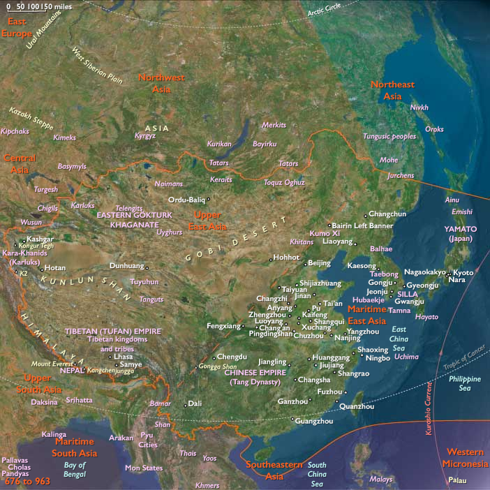
Upper East Asia includes Mongolia and western China, encompassing Tibet, Xinjiang, Qinghai, Gansu, Ningxia, Inner Mongolia, and western Heilongjiang.
-
The subregion spans the Tibetan Plateau, the Gobi Desert, the Altai Mountains, and arid basins such as the Tarim and Hexi Corridor.
-
It served as a strategic crossroads between the Chinese heartland, Central Asia, and the northern steppe.
Climate and Environmental Shifts
-
A continental and high-altitude climate prevailed, with long winters, short summers, and limited rainfall.
-
Oases and river valleys enabled farming in Xinjiang and Gansu, while the plateau and steppe supported pastoralism.
-
Periodic droughts and shifting steppe conditions influenced nomadic migrations and political pressures on neighbors.
Societies and Political Developments
-
The Tibetan Empire, dominant in the 7th–8th centuries, fragmented by the mid-9th, with regional warlords and monastic centers filling the vacuum.
-
In Mongolia and the northern steppes, Turkic and Mongolic tribes organized into shifting confederations after the fall of the Uyghur Khaganate (840).
-
The Tang Dynasty of China (618–907) gradually weakened, losing firm control of the western regions; local warlords and military governors filled the gap.
-
By the 10th century, post-Tang successor states and regional powers such as the Khotan Kingdom and Gansu Uyghurs controlled key Silk Road oases.
-
In the Hexi Corridor, fortified towns became contested points among Chinese, Tibetan, and steppe powers.
Economy and Trade
-
Oasis agriculture (wheat, barley, grapes, cotton) supported dense populations in Tarim Basin towns like Khotan and Turfan.
-
Tibetan highlands relied on barley cultivation, yak herding, and salt extraction.
-
Steppe societies raised horses, sheep, and camels, trading livestock and animal products southward.
-
Silk Road caravans carried silk, jade, and porcelain westward, returning with silver, glass, and horses.
-
Tribute systems linked frontier states with Tang China and later successor dynasties.
Subsistence and Technology
-
Irrigation canals and qanats sustained desert oases.
-
Mounted cavalry with composite bows dominated warfare across steppes and frontiers.
-
Tibetan Buddhism advanced, with monasteries becoming centers of literacy and landholding.
-
Chinese gunpowder experimentation and woodblock printing began in this broader era, though concentrated in the east.
Movement and Interaction Corridors
-
The Silk Road through the Tarim Basin and Hexi Corridor remained the main artery between China and Central Asia.
-
Tibetan passes linked the plateau with Nepal, India, and Inner Asia.
-
Steppe routes connected Mongolia to the Caspian steppes and Manchuria.
-
The Gansu corridor tied northern Chinese states to frontier polities.
Belief and Symbolism
-
Buddhism flourished in Tibet and Tarim Basin states, with monumental cave complexes at Dunhuang and Kizil.
-
Manichaeism and Nestorian Christianity persisted among Uyghur groups.
-
Indigenous shamanic and sky-god traditions remained central to steppe societies.
-
Ritual art, manuscripts, and religious iconography blended Indian, Persian, and Chinese influences.
Adaptation and Resilience
-
Nomadic mobility enabled steppe groups to survive drought and resource scarcity.
-
Oasis towns fortified their walls and stockpiles to endure sieges and shifting power struggles.
-
Tibetan plateau communities relied on barley, yaks, and salt as ecological stabilizers.
-
Trade diversification reduced dependence on any single route or crop.
Long-Term Significance
By 963, Upper East Asia was a mosaic of fragmented powers: Tibet in disunity, Tang China collapsing, Uyghur refugees adapting, and oasis states thriving on trade. Its cultural and political dynamism foreshadowed new steppe empires and Buddhist renaissances in the centuries ahead.
Images

Upper East Asia (with civilization) ©2024-25 Electric Prism, Inc. All rights reserved.
Groups
Commodities
Regions
East Asia
View →Subregions
