Southern Australasia (1684–1827 CE): Firestick Farming, Seasonal…
1684 CE to 1827 CE
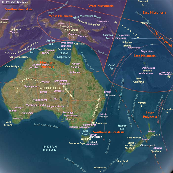
Southern Australasia (1684–1827 CE): Firestick Farming, Seasonal Gatherings, and Early Encounters
Geography & Environmental Context
Southern Australasia comprises the southern two thirds of Australia—including New South Wales, Victoria, South Australia, southern and central Western Australia and Queensland, southern Northern Australia, and Tasmania—together with New Zealand’s South Island and the extreme southwest of the North Island. Anchors include the Murray–Darling Basin, the Great Dividing Range, the Victorian Alps, the karri forests of southwestern Western Australia, the Flinders Ranges, the Tasmanian highlands, the Canterbury Plains and Southern Alps of New Zealand’s South Island, and the Taranaki and Wellington regions of the North Island’s extreme southwest. This subregion combines expansive riverine plains, temperate forests, semi-arid interiors, alpine landscapes, and maritime coasts.
Climate & Environmental Shifts
Climatic rhythms reflected both monsoonal influences in northern fringes and temperate variability further south. El Niño–Southern Oscillation cycles drove alternating floods and droughts across the Murray–Darling. The Little Ice Age persisted, with cooler winters, heavier frosts, and shorter growing seasons in alpine zones of Tasmania and New Zealand. Periodic bushfires shaped Australian ecologies, while New Zealand’s South Island experienced heavy rainfall and snowmelt cycles feeding braided rivers and glacial valleys.
Subsistence & Settlement
Indigenous peoples practiced flexible, regionally adapted lifeways:
-
Southeastern Australia (New South Wales, Victoria): The Gunditjmara engineered extensive stone channels and weirs to trap and farm eels, sustaining semi-sedentary communities. Elsewhere, mobility followed cycles of yam harvests, kangaroo hunts, and grass seed gathering.
-
Tasmania: The Palawa pursued seasonal rounds of wallaby, seal, and bird hunting, along with shellfish gathering and root harvesting, supported by fire-managed landscapes.
-
South and Western Australia: Groups relied on tubers, seeds, and marsupial hunting, while exploiting estuaries, shellfish beds, and seasonal waterholes.
-
Southern Queensland and Northern Territory (temperate fringe): Mobility aligned with rainfall, focusing on plant foods, freshwater fisheries, and game.
-
New Zealand (South Island and southwestern North Island): Ngāi Tahu and neighboring Māori communities cultivated kūmara in the warmer north, while fern root, fishing, birding, and seasonal expeditions for pounamu (greenstone) dominated in the south. Settlements ranged from coastal pā (fortified villages) to inland seasonal camps.
Technology & Material Culture
Material culture reflected adaptation to diverse ecologies:
-
Stone tools remained essential, including ground-edge axes in Australia and polished pounamu adzes in New Zealand.
-
Fishing technologies included woven nets, stone traps, and fish weirs; eel traps in Victoria represented sophisticated aquatic engineering.
-
Bark canoes and rafts supported inland and coastal movement, while waka taua (war canoes) in New Zealand enabled both trade and warfare.
-
Clothing: Kangaroo and possum-skin cloaks in Australia, fur and feather cloaks in New Zealand, and kelp water carriers in Tasmania.
-
Carved wooden implements, body ornamentation, and rock art or wood carving expressed spiritual connections to land and ancestors.
Movement & Interaction Corridors
Mobility followed ecological and ritual calendars:
-
Australia: Songlines (Dreaming tracks) connected sacred landscapes and guided seasonal journeys. Large intergroup gatherings occurred at eel harvests (Victoria), bogong moth hunts (Snowy Mountains), and coastal feasts. Exchange moved ochre, stone, and ritual knowledge across territories.
-
Tasmania: Movements between inland hunting grounds and coastal seal rookeries maintained balance between marine and terrestrial resources.
-
New Zealand: Trails carried pounamu from South Island quarries to North Island communities, embedding the stone in a pan-Polynesian prestige economy. Coastal canoe routes linked pā communities and facilitated raiding and alliance-building.
-
From the late 18th century, European explorers (Cook, d’Entrecasteaux, Baudin, Vancouver, Flinders) began mapping coasts. Whalers and sealers soon frequented Bass Strait, Tasmania, and New Zealand waters, introducing iron tools, cloth, and firearms, as well as epidemic diseases.
Cultural & Symbolic Expressions
-
Australia: The Dreaming (Tjukurpa) tied clans to creation beings and sacred sites; ceremonies with dance, song, and body painting reaffirmed cosmological order. Rock engravings, scarred trees, and stone arrangements marked sacred locales.
-
Tasmania: Seasonal rituals honored hunting grounds and seashores; kin groups reinforced ties through story, dance, and shared food.
-
New Zealand: Whakapapa (genealogy) linked people to gods and land, while marae-centered rituals anchored communal identity. Haka (ritual dance), carved meeting houses, and pounamu ornaments embodied both mana and tapu.
Environmental Adaptation & Resilience
-
Firestick farming in Australia maintained open woodlands, promoted tuber growth, and supported game hunting.
-
Storage systems—eel smoking, bread-making from fern root, drying of fish and birds—buffered lean months.
-
Mobility and diversification allowed communities to adjust to drought, flood, or frost.
-
Pounamu exchange networks reinforced resilience in New Zealand, embedding resource circulation within kinship and ritual systems.
-
Social structures of reciprocity, feasting, and alliance maintained balance in both human and ecological realms.
Transition
Between 1684 and 1827, Southern Australasia remained firmly indigenous in lifeways, with landscapes managed by fire, ritual, and seasonal mobility. Engineered eel channels, yam and taro gardens, and pounamu quarries anchored sophisticated systems of production and exchange. Yet by the late 18th century, explorers, whalers, and sealers marked the arrival of new global forces. Iron and firearms filtered into exchange systems, while disease and early conflict foreshadowed deeper disruption. By 1827, the subregion stood at the threshold: still defined by Dreaming tracks, eel harvests, and marae rituals, but increasingly aware of sails on the horizon.
Groups
Topics
Subjects
Regions
Australasia
View →Subregions
