West Central Europe (1828–1971 CE): Industrial Corridors,…
1828 CE to 1971 CE
West Central Europe (1828–1971 CE): Industrial Corridors, War-Torn Frontiers, and Postwar Integration
Geography & Environmental Context
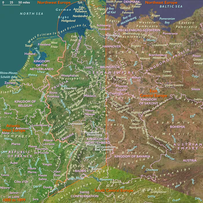
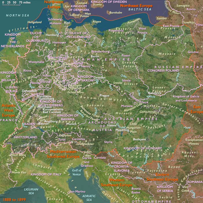
West Central Europe comprises modern Germany west of 10°E and the Rhine-adjacent far northwest of Switzerland, including the northern Jura. Anchors include the Middle and Upper Rhine Valley, the Moselle and Main tributaries, the Eifel and Hunsrück uplands, the northern Black Forest, and the northern Jura. Major cities—Cologne, Frankfurt, Mainz, Strasbourg, Heidelberg, Basel, and Bonn—lined riverine arteries that connected local industries to North Sea ports and continental markets.
Climate & Environmental Shifts
The region’s temperate climate supported intensive agriculture and heavy industry. River floods periodically disrupted trade (notably Rhine floods in the 19th century), while urban pollution became a major environmental stressor after 1850. The “Year Without a Summer” effects lingered into the 1830s, sparking food crises, while industrial coal burning later darkened skies in the Ruhr and Rhine valleys. After World War II, ecological recovery and Rhine clean-up began in earnest.
Subsistence & Settlement
-
19th century agriculture: Villages practiced cereal farming (rye, wheat, barley) alongside vineyards on the Rhine and Moselle. Potato adoption stabilized diets, supporting demographic growth.
-
Industrial settlements: The Ruhr–Rhine corridor grew into one of Europe’s densest industrial landscapes, with coal, steel, chemicals, and machine production. Cologne, Düsseldorf, and Essen became industrial powerhouses.
-
Urbanization: Frankfurt evolved into a financial center; Basel integrated into Swiss banking; Strasbourg oscillated between French and German control, reshaping its civic identity.
-
20th century rebuilding: After wartime devastation, modernist housing and infrastructure spread, creating postwar suburbs and new industrial zones.
Technology & Material Culture
-
Industrialization: Coal mines, blast furnaces, and textile mills expanded from the 1830s; railways and canals linked mines to markets.
-
Infrastructure: The Rhine was canalized and deepened; bridges and rail lines (Cologne, Mainz, Basel) knitted together transport. Autobahns in the 1930s and postwar highways in the 1950s redefined mobility.
-
Cultural production: Printing and publishing (Frankfurt Book Fair, Basel presses), Romantic art and music, later Expressionist and modernist movements, and post-1945 film and television shaped regional identity. Everyday material life shifted from peasant cottages to industrial apartments, then to modern homes filled with consumer goods after the 1950s.
Movement & Interaction Corridors
-
Rhine artery: Bulk cargoes (coal, iron, grain, wine) moved continuously between Basel, Cologne, and Rotterdam.
-
Railroads: By the 1850s, Frankfurt, Mainz, Strasbourg, and Basel were nodes of continental railway webs.
-
Military corridors: The Rhine frontier witnessed French invasions (1870, 1914, 1940) and Allied advances (1945).
-
Postwar integration: West Germany’s Rhine corridor became central to the European Coal and Steel Community (1951) and later the EEC (1957), integrating Basel, Strasbourg, and Cologne into a shared European market.
Cultural & Symbolic Expressions
-
Romanticism (19th century): Rhine castles, ruins, and legends inspired painters and poets, embedding the Rhine in European imagination.
-
Nationalism: Cathedral restorations (Cologne Cathedral completed in 1880) symbolized nationhood; Alsace’s cultural oscillation symbolized Franco-German rivalry.
-
20th century fracture: Nazi propaganda dominated in the 1930s–40s; Jewish communities of Cologne, Mainz, and Frankfurt were destroyed in the Holocaust.
-
Postwar culture: The Rhine again became a symbol of cooperation; Strasbourg housed the Council of Europe (1949) and later the European Parliament (1952). Festivals, fairs, and wine culture revived as markers of peace and prosperity.
Environmental Adaptation & Resilience
-
19th century: Agricultural diversification (potatoes, vineyards, dairy) mitigated food crises; communal granaries and charity buffered lean years.
-
Industrial age: Pollution, flooding, and over-urbanization stressed resources, yet canalization and reforestation projects stabilized trade and environments.
-
Postwar recovery: Marshall Plan aid and European cooperation rebuilt industry; welfare states provided resilience against poverty and displacement. Flood defenses and environmental regulation in the 1950s–60s marked the start of ecological awareness.
Political & Military Shocks
-
1848 Revolutions: Frankfurt hosted the first attempt at German unification.
-
Franco-Prussian War (1870–71): Strasbourg and Alsace annexed by Germany.
-
World War I (1914–1918): Western Front scarred Alsace-Lorraine and the Rhine frontier.
-
World War II (1939–1945): Nazi rule, Allied bombing (Cologne, Frankfurt, Mainz, Strasbourg), and mass deportations devastated the region.
-
Post-1945 division: West Central Europe (in West Germany, France, and Switzerland) became a Cold War frontline, but also a foundation of European unity.
Transition
Between 1828 and 1971, West Central Europe transformed from a patchwork of agrarian villages and small states into one of Europe’s most industrialized and urbanized cores. The Rhine River remained the backbone—first of industrial might, then of war, and finally of peace and integration. After devastation in two world wars, West Central Europe became a keystone of postwar Europe: symbolized by Strasbourg as a European capital, Cologne as an industrial hub, Frankfurt as a financial center, and Basel as a banking and cultural bridge. By 1971, the region had emerged as both an economic powerhouse and a symbol of reconciliation, anchoring Western Europe’s unity in the Cold War era.
Images

West Central Europe (with civilization) ©2024-25 Electric Prism, Inc. All rights reserved.
Groups
Topics
Commodities
Subjects
Regions
Central Europe
View →Subregions