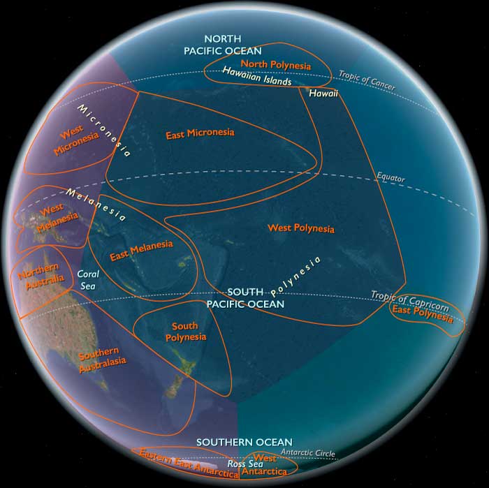
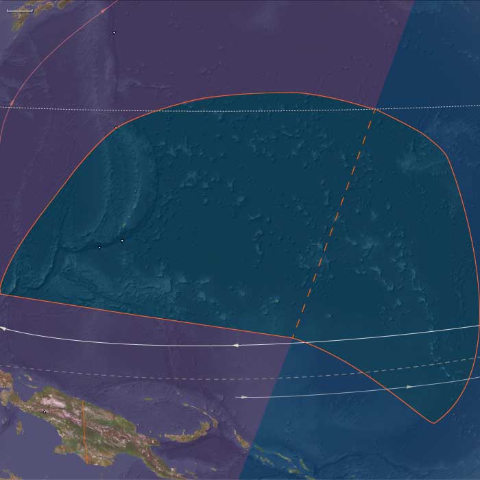
Central Oceania
Related Events
Showing 10 events out of 437 total
Polynesia (49,293 – 28,578 BCE): Upper Paleolithic I — Volcanic Arcs, Reef Foundations, and the Architecture of Isolation
Geographic & Environmental Context
During the later Pleistocene, the Polynesian sector of the Pacific was a scattered domain of volcanic peaks, emerging atolls, and widening reef flats—a geography still entirely devoid of humans but already constructing the natural architecture that would one day sustain them.
The region spanned three great arcs of islands:
-
The Hawaiian–Emperor chain in the north, including Oʻahu, Maui, Molokaʻi, Kauaʻi, Niʻihau, and Midway, where high volcanic forms dominated the subtropics.
-
The central–western archipelagos—Tonga, Samoa, the Cook and Society Islands, the Marquesas, Tuvalu, and Tokelau—a mixture of high volcanic islands, raised limestone platforms, and embryonic atolls.
-
The eastern fringe—future Pitcairn and Rapa Nui—where lone volcanic edifices rose from deep ocean basins, linked only by the great South Pacific gyres and currents.
Sea level stood ~100 m lower than today, exposing vast coastal benches and broad shelves around high islands. Many modern lagoons lay dry, their reef rims fossilized in the air; others built episodically with interglacial warm phases. Across the region, reef, volcano, and ocean interacted in long cycles of uplift and subsidence—the slow choreography that would, over tens of millennia, produce the Polynesian Triangle’s intricate geography.
Climate & Environmental Shifts
The epoch was framed by full glacial conditions—cooler sea-surface temperatures, stronger trade winds, and a sharply defined dry season.
-
Atmosphere and Ocean: Strengthened trades drove upwelling along many leeward coasts, favoring cool, nutrient-rich nearshore waters. Seasonal dust episodes and winter surf reworked coastal benches, while the intertropical convergence zone (ITCZ) oscillated northward and southward with orbital rhythms.
-
Late-Glacial Variability: Even within the long glacial, brief mild interstadials brought short-lived reef growth spurts and pulses of vegetation recovery. Cooler phases depressed the coral-algal community but expanded coastal steppe and dry scrub.
-
Volcanic Activity: Continuous effusive volcanism in the Hawaiian Big Island and intermittent eruptions in the Societies, Marquesas, and Cooks rejuvenated landscapes, built fresh lava plains, and created ephemeral crater lakes and ash-fed soils.
Overall, Polynesia’s climate oscillated between cool, windy glacial stability and short warming pulses that allowed the reef crest and forest line to advance and retreat in rhythm with the global climate.
Biota & Baseline Ecology (No Human Presence)
Every island was its own closed laboratory of evolution.
-
Marine Life:
Coral communities fluctuated with sea level and temperature, but even under glacial suppression, shallow fringing reefs persisted. Fish, mollusk, turtle, and seabird populations were immense, their only predators sharks and seals. On outer banks like Midway, Tokelau, and Tuvalu, monk seals and turtles bred in numbers far exceeding modern densities. -
Terrestrial Life:
The higher islands—Hawaiʻi, Tahiti, Samoa, the Marquesas—carried dense montane forests in windward belts and dry woodland or grass steppe on leeward slopes. Cloud forests crowned the summits, capturing mist even under glacial dryness. Each island hosted unique, isolated assemblages of birds, insects, and plants, evolving in splendid isolation. -
Avian Realms:
Seabird supercolonies occupied cliffs and stacks, fertilizing soils with guano and enriching nearshore ecosystems. On atolls and cays, the air was dense with terns, boobies, and petrels—an avian kingdom uninterrupted by human disturbance.
Environmental Processes & Dynamics
-
Reef and Lagoon Evolution: Lower sea levels exposed broad reef flats, which weathered into limestone benches; with each brief warming, corals recolonized and built new terraces—a staircase of future lagoons.
-
Volcano–Erosion Cycles: Heavy rainfall on high islands carved deep amphitheaters (e.g., Waiʻanae, Koʻolau, and Tahiti’s ancient calderas), while aridity on leeward slopes preserved lava plains and dunes.
-
Marine Productivity: Upwelling zones around island chains created feeding grounds for pelagic fish and whales; kelp-like macroalgae likely formed dense nearshore beds in cooler zones, anchoring early “reef forest” ecologies.
-
Atmospheric Circulation: Persistent trades sculpted the cloud belts that would later define Polynesian ecological duality—lush windward valleys and dry leeward coasts.
Long-Term Significance
By 28,578 BCE, Polynesia’s physical and biological foundations were firmly in place:
-
Volcanic arcs had matured into high-island chains with deep, fertile amphitheaters and developing river networks.
-
Coral reef systems, though suppressed by glacial cooling, had established their long-term frameworks, ready to surge during Holocene sea-level rise.
-
Forest and reef ecologies had stabilized into enduring zonations—ridge forests, dry scrub, coastal strand, reef-flat, and pelagic edge—that would persist through the Holocene.
The epoch thus created Polynesia’s essential blueprint: a world of towering volcanic islands, expanding reef terraces, seabird-sustained fertility, and unbroken ecological isolation.
In the ages to come, these formations would become the living stage for one of Earth’s greatest human voyaging traditions—a future civilization built upon the deep-time architecture of glacial Polynesia.
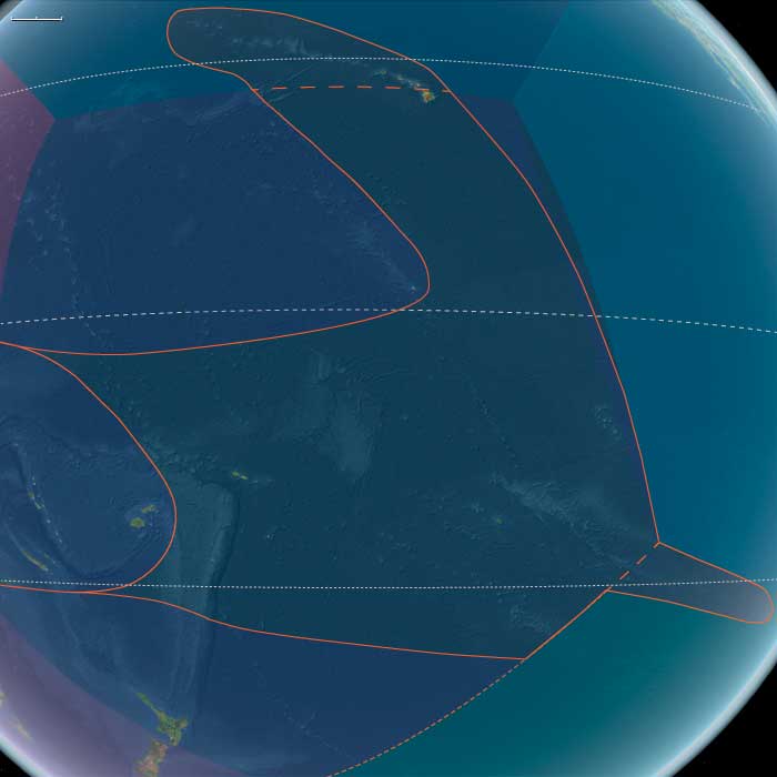
West Polynesia (49,293 – 28,578 BCE): Upper Paleolithic I — Volcanic High Islands, Atoll Seeds, and Reef-Edge Biota
Geographic & Environmental Context
West Polynesia includes Hawaiʻi Island (the Big Island); Tonga (Tongatapu, Haʻapai, Vavaʻu); Samoa (Savaiʻi, Upolu, Tutuila/Manuʻa); Tuvalu and Tokelau (low atolls); the Cook Islands (Rarotonga, Aitutaki, Mangaia, etc.); Society Islands (Raiatea–Tahiti–Moʻorea–Bora Bora); and the Marquesas (Nuku Hiva, Hiva Oa).
-
Hawaiʻi Island still in an active shield-building phase (Mauna Loa, Mauna Kea); Societies, Marquesas, Cooks are high volcanic islands; Tuvalu–Tokelau are emergent low reef structures and paleo-atolls; Tonga–Samoa high islands/raised limestones.
Climate & Environmental Shifts
-
Glacial world: sea level ~100 m lower; wide reef flats and drowned shelves exposed terraces and benches. Trades strong; cooler SSTs.
Biota & Baseline (No Human Presence)
-
Seabird supercolonies, turtle rookeries, monk seals (in NW line) on outer cays; uplands carry cloud/montane forests, leeward slopes dry woodland.
-
Reef accretion proceeds episodically; lagoons are shallower and more extensive than today.
Long-Term Significance
A geomorphic blueprint forms: high islands with fertile amphitheaters and burgeoning barrier reefs—future foundations for intensive ridge-to-reef food systems.
Micronesia (49,293 – 28,578 BCE): Upper Pleistocene I — Submerged Ridges, Atoll Seeds, and the Empty Reefs of a Cooler Pacific
Geographic & Environmental Context
During the later Pleistocene, Micronesia stretched across a vast mid-Pacific sweep of volcanic highs, raised limestone plateaus, and nascent atoll rims poised atop the Pacific Plate. The region was already divided into its two enduring structural arcs:
-
West Micronesia: the Mariana Islands (Guam, Saipan, Tinian, Rota, and the northern seamount chain), Palau(Babeldaob, Koror, Rock Islands), and Yap with its surrounding low atolls (Ulithi–Woleai arc).
These islands formed along ancient volcanic and tectonic arcs rising from deep basins—rugged highlands and carbonate terraces that stood above a narrow shelf. -
East Micronesia: the Marshall Islands (Ralik and Ratak chains), the Gilberts (Kiribati), Nauru, and the eastern Carolines (Kosrae)—a realm of reefed ridges, uplifted limestones, and isolated volcanic cones surrounded by wide lagoon systems.
At this time, sea level lay roughly 100 meters below modern, exposing reef flats and submerged coastal terraces across the entire Pacific basin. Many of today’s lagoons and passes existed only as broad intertidal plains or dry benches. The exposed reefs baked under strong trade winds and saline spray, while the high islands of Palau, Yap, and Kosrae maintained forested uplands and perennial streams under cooler, drier skies.
Climate & Environmental Shifts
The Late Pleistocene Pacific was a cooler, windier world, governed by strengthened trade winds and steeper thermal gradients between equator and subtropics:
-
Temperature & Ocean Circulation: Sea-surface temperatures dropped 2–3 °C below present. The west Pacific warm pool contracted eastward, reducing rainfall over central Micronesia.
-
Rainfall & Storms: Monsoon and intertropical convergence zones shifted northward; dry seasons lengthened, and cyclone frequency declined under a more stable, cooler ocean–atmosphere regime.
-
Sea Level & Geomorphology: Reef accretion slowed or paused; many atoll rims stood high and dry as limestone terraces. Submerged seamounts, ridges, and banks—future Ralik–Ratak, Palau–Yap, and Ulithi–Woleai chains—were transformed into low scrub islands or bare carbonate plains.
-
Volcanism: Kosrae, Palau, and the northern Marianas remained volcanically active, releasing ash that enriched soils and supported cloud forest pockets.
Biota & Baseline Ecology (No Human Presence)
Though entirely uninhabited, the Micronesian region supported vibrant marine and avian ecosystems, organized along windward–leeward contrasts and high–low island gradients.
-
Marine Systems:
• Coral diversity contracted but persisted on outer slopes below the lowered sea level.
• Exposed flats hosted intertidal mollusks, crabs, and urchins, while submerged reef slopes remained refuges for reef fish and sharks.
• Cooler waters and upwelling zones favored planktonic blooms around high islands and seamount edges, sustaining pelagic fish and turtles. -
Terrestrial & Avian Life:
• Seabird supercolonies dominated the low atolls and terraces—boobies, terns, frigatebirds, petrels—depositing guano that enriched emerging soils.
• Turtles nested on extensive beaches exposed by low sea stands.
• On volcanic high islands (Yap, Palau, Kosrae), montane forests of ferns, pandanus, and palms persisted, harboring endemic birds, fruit bats, and invertebrates.
• Nauru’s elevated plateau supported scrub adapted to aridity and phosphate-rich soils.
Environmental Processes & Dynamics
-
Reef Morphodynamics: Exposed reefs weathered and fractured; their margins became the foundation for the Holocene reef rims and lagoon systems that would later define Micronesian atolls.
-
Hydrological Cycles: Reduced rainfall limited freshwater lenses on low islands, while high islands retained groundwater-fed streams and crater lakes.
-
Wind and Sediment: Persistent trades reworked coral rubble into beach ridges and dunes—landforms that fossilized as Pleistocene terraces visible in many modern atolls.
-
Ocean Productivity: The combination of cooler waters and intensified upwelling sustained rich pelagic ecosystems around all major island arcs, even as shallow reefs lay dormant.
Symbolic & Conceptual Dimensions
No humans yet traversed this ocean. For tens of millennia, Micronesia existed only as a biological archipelago—reef to reef, wind to current—its atolls forming unseen scaffolds for the civilizations to come. Every island was a silent nursery: for coral larvae drifting on trade winds, for seabird colonies seeding future soils, for volcanic ridges waiting to host human voyagers millennia hence.
Environmental Adaptation & Resilience
The ecosystems of both western and eastern Micronesia demonstrated striking resilience:
-
Coral frameworks survived exposure and reemerged once seas rose.
-
Guano fertilization jump-started terrestrial soil development.
-
Volcanic renewal on Palau, Yap, and Kosrae maintained forest refugia during dry glacial phases.
-
Ocean circulation ensured continual nutrient renewal even during climatic downturns.
These processes collectively prepared Micronesia for the Holocene transgression, when reefs would again flourish and lagoons fill—a transformation that would give the region its modern face.
Long-Term Significance
By 28,578 BCE, Micronesia was already architecturally complete in geological terms:
-
Reef platforms, high-island watersheds, and carbonate terraces had all been established.
-
The region’s biological endemism and reef frameworks were in place, awaiting Holocene recolonization by corals, forests, and, eventually, humans.
-
Its position at the confluence of the equatorial currents and trade-wind belts had fixed the environmental patterns that would later shape Micronesian navigation, settlement, and subsistence.
In essence, the glacial Micronesian world was a prelude in stone and coral—the formation of the reefs, lagoons, and winds that would one day become the foundation of the Pacific’s smallest yet most interconnected oceanic realm.
East Micronesia (49,293 – 28,578 BCE): Upper Pleistocene — Reef Platforms, Windward Rims, and Seabird Realms (No Human Presence)
Geographic & Environmental Context
East Melanesia includes Kiribati (Gilbert Islands), the Marshall Islands (Ralik and Ratak chains), Nauru (uplifted phosphatic limestone island), and Kosrae (high, volcanic island on the eastern Caroline arc).
-
Sea level sat ~100 m below modern, exposing broad reef flats and terrace benches on the future Ralik–Ratak and Gilbert atolls; Nauru stood as a higher limestone mesa; Kosrae loomed as a steep volcanic high island with deep valleys.
Climate & Environmental Shifts
-
Last Glacial Maximum: cooler SSTs, stronger trades and winter swell; slower coral accretion but wide intertidal zones.
Baseline Ecology
-
Seabird supercolonies nested on outer cays; turtles used broad beaches; lagoonal microhabitats were incipient.
-
Kosrae’s montane forest and unmodified streams sustained high freshwater biodiversity.
Long-Term Significance
These lowstand landscapes fixed the reef foundations and high-island watersheds that later support Micronesian arboriculture, taro pondfields, and lagoon fisheries.
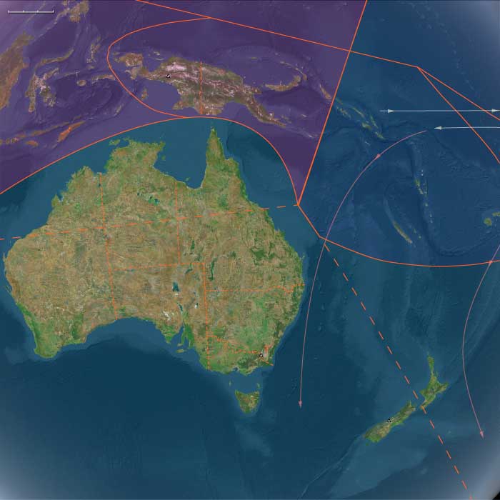
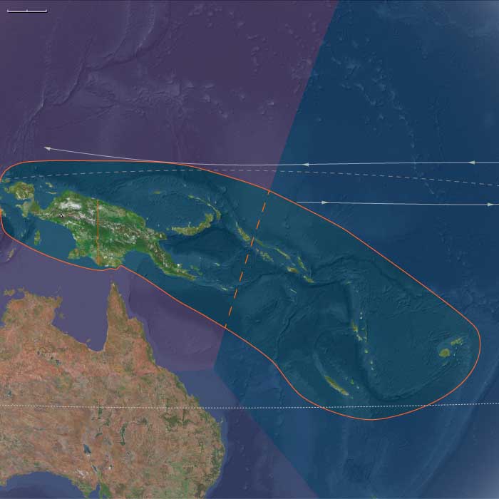
Melanesia (49,293 – 28,578 BCE): Upper Pleistocene I — Sahulian Highlands, Volcanic Arcs, and the Unpeopled Frontiers of Remote Oceania
Geographic & Environmental Context
During the height of the Late Pleistocene glaciation, Melanesia was divided into two very different worlds:
-
The western realm, including New Guinea, the Bismarck Archipelago, and the northern Solomons (Bougainville–Buka)—all part of the larger Sahul continent joined to Australia by the exposed Torres Shelf.
-
The eastern realm, the isolated island chains of Vanuatu, Fiji, New Caledonia, and the central–eastern Solomons (Guadalcanal–Malaita–Makira–Santa Cruz)—the volcanic and coral highlands of Remote Oceania, still uninhabited by humans.
Sea level lay roughly 100 meters below present, exposing broad continental shelves in the west and narrowing reef lagoons in the east. The Sahulian landmass extended north into Arafura–Carpentaria plains, while New Guinea’s central ranges rose into glaciated heights with periglacial basins and frost-prone valleys.
To the east, Vanuatu, Fiji, and New Caledonia stood as isolated volcanic arcs emerging steeply from deep basins—ecologically rich but geographically inaccessible to the foragers of the western coasts.
Climate & Environmental Shifts
-
Glacial World (49–30 ka):
Mean sea-surface temperatures across the Southwest Pacific were 2–3 °C cooler. Trade winds strengthened, intensifying upwelling on leeward coasts and bringing drier conditions to New Guinea’s highlands and valleys. The Central Cordillera supported small alpine glaciers, and montane forests gave way to open grassland and subalpine scrub. -
Toward the LGM (~30–28 ka):
Aridity peaked; coastal mangroves retreated; many lowland rivers cut deeply into exposed continental shelves. Cyclones and volcanic activity persisted episodically across the arc from New Britain to Fiji. -
Regional Contrast:
Western Melanesia retained significant rainfall and river flow, while Remote Oceania remained wetter overall but climatically cooler and more seasonally variable.
Western Melanesia: The Sahulian Heart
By this epoch, modern humans had long been established in New Guinea and the Bismarcks, forming one of the world’s most enduring highland–lowland adaptations.
-
Subsistence & Settlement
Foragers occupied glacial uplands such as the Ivane Valley (Central Highlands) and Kafiavana, where hearths, stone flakes, and grindstones attest to cold-climate resource management—small-game hunting, nut and tuber gathering, and controlled fire use to maintain open ground.
Along the Sepik–Ramu and Papuan Gulf, coastal and riverine communities exploited fish, mollusks, and estuarine mammals; reef flats now stranded high and dry would later become mangrove forests.
Fire regimes reshaped highland grasslands, encouraging regrowth and visibility for marsupial hunts, while wild tubers (precursors of yam and taro) were deliberately managed in cleared patches—the world’s earliest evidence of proto-horticultural systems. -
Technology & Material Culture
Flaked quartz and chert tools dominated; ground-stone axes began to appear for woodworking. Plant-fiber nets and string bags, now perishable, were probably in common use. Ochre and hematite were employed for body painting and symbolic burials.
Shelters—rock overhangs and built windbreaks—were adapted to frost and seasonal cold. -
Movement & Interaction Corridors
River corridors (Strickland, Fly, Sepik, Ramu) served as travel and exchange routes, connecting inland valleys with coastal lowlands. Although full ocean crossings were still rare, obsidian from New Britain occasionally reached New Guinea sites, hinting at incipient seafaring competence along sheltered coasts and straits. -
Cultural & Symbolic Life
Pigment use and ritualized burials reveal social continuity and symbolic depth. Fire—both a practical and ceremonial tool—was central to highland identity and landscape management.
Eastern Melanesia: The Unpeopled Frontier
Beyond the Sahul shelf lay Remote Oceania, a vast Pacific expanse scattered with volcanic arcs and coral plateaus—Vanuatu, Fiji, New Caledonia, and the eastern Solomons—all still empty of human life.
-
Ecosystems and Biota
Dense rainforests and cloud forests cloaked the high islands, nourished by volcanic soils. Reef and lagoon systems were narrower at glacial lowstand but maintained robust coral and fish populations. Seabird colonies, turtles, and flying foxes dominated terrestrial fauna; large reptiles and endemic birds filled ecological niches undisturbed by mammalian predators. -
Environmental Stability
Despite cooler sea-surface temperatures, reef–lagoon productivity remained high, buffering ecosystems through climatic oscillations. Volcanic ash periodically enriched soils, supporting evergreen canopies. These landscapes matured in isolation—an ecological Eden awaiting human discovery.
Environmental Adaptation & Resilience
Across the entire Melanesian domain, resilience stemmed from diversity and isolation:
-
In Western Melanesia, flexible foraging and fire-based ecosystem management allowed human populations to thrive through glacial extremes.
-
In Eastern Melanesia, biological systems maintained equilibrium without human influence—reefs recovered, forests recycled, and volcanoes renewed soils on cyclical timescales.
The contrast between peopled west and empty east defined Melanesia’s enduring duality: one a cradle of continuous habitation and innovation, the other a pristine wilderness preserved by distance.
Transition Toward the Holocene
By 28,578 BCE, Western Melanesian foragers had mastered every ecological zone from alpine valleys to coral flats, forming the cultural base of the later Papuan–Austronesian continuum.
To the east, volcanic and coral islands awaited the rise of sea levels and the eventual emergence of long-range voyagers.
The post-glacial world would soon redraw coastlines, creating new estuaries, lagoons, and archipelagos—the stage on which Lapita seafarers would one day appear.
But for now, Melanesia remained a divided world: the oldest continuously inhabited mountains on Earth facing a still-unpeopled Pacific horizon.
East Melanesia (49,293–28,578 BCE) Vanuatu, Fiji, New Caledonia, central/eastern Solomons
Geographic & Environmental Context
East Melanesia includes Vanuatu, Fiji, New Caledonia, central/eastern Solomons (Guadalcanal–Malaita–Makira–Santa Cruz).
Anchors: Grande Terre reef-lagoon rim (New Caledonia), Vanuatu arc volcanoes, Fiji high islands & Lau passages, Solomon trench/lagoons.
-
Remote Oceania islands rising steeply from deep basins; reef-lagoon systems narrower at lowstand; inter-island distances substantial.
Climate & Environmental Shifts
-
LGM: cooler SSTs, stronger trades; reduced rainfall; cyclones still episodic.
Subsistence & Settlement
-
No humans yet (Remote Oceania was not peopled until the mid-late Holocene, Lapita ~3.5 ka). Ecosystems dominated by seabirds, reef fish, and forest endemics.
Technology / Corridors / Symbolism
-
N/A (pre-human).
Environmental Adaptation & Resilience
-
Reef/lagoon productivity robust; volcanic soils accumulated under closed-canopy forests.
Transition
-
Post-LGM sea rise will build wide back-reef ponds and passes — the future stage for Lapita seafaring dispersals.
Australasia (49,293 – 28,578 BCE): Upper Pleistocene I — Continental Shelves, Fire Country, and the Unpeopled Islands of the Far South
Geographic & Environmental Context
During the long glacial prime of the Late Pleistocene, Australasia stretched as a single vast, connected super-land: the Sahul continent, where Australia, New Guinea, and Tasmania were joined by the broad Arafura and Carpentaria shelves, while across the Tasman Sea, the New Zealand–Norfolk–Kermadec arc stood isolated, volcanically active, and entirely uninhabited by humans.
The region’s physiography displayed extremes of exposure and contrast:
-
To the north, tropical savannas and monsoon coasts extended from Kimberley and Arnhem Land through Cape York to the low divide of southern New Guinea, while the Gulf of Carpentaria held a vast inland sea–wetland complex.
-
Across central and southern Australia, vast dune fields, salt lakes, and desert basins alternated with fertile riverine corridors like the Murray–Darling and the Willandra Lakes.
-
In the south, the Bassian Plain connected the mainland to Tasmania, while New Zealand remained beyond human reach—its forests, volcanic zones, and seabird cliffs untouched.
Sea level lay ~100 m below present, enlarging the continental shelves and exposing wide coastal plains, which were colonized by both humans (in Australia) and dense faunal populations.
Climate & Environmental Shifts
-
Early Glacial Phase (~49–35 ka): Gradual cooling, declining precipitation in continental interiors, and expansion of arid belts; forest contraction in the tropics and southeast.
-
Approach to the Last Glacial Maximum (~35–28 ka): Sharper temperature drop, stronger seasonality, and intensified westerlies and trade winds. Northern monsoons weakened, and interior lakes fell or dried episodically.
-
Regional Contrasts:
• Northern Australia remained humid enough for monsoon-driven wet–dry cycles, sustaining aquatic ecosystems along rivers and coasts.
• Southern Australia and Tasmania cooled markedly, with snowfall on upland ranges and alpine conditions in the Great Dividing Range and Tasmanian highlands.
• New Zealand entered full glaciation: the Southern Alps carried expanded glaciers, and snowlines dropped by hundreds of meters.
The climate oscillated between long cold stasis and short, mild interstadials—conditions that defined both human adaptive strategies and the evolutionary dynamics of uninhabited island ecologies.
Human Presence and Lifeways
Human societies were firmly established across the Australian continent and the connected Sahul landmass, but absent east of the Tasman frontier.
Northern Australasia (Sahul Tropics)
-
Occupation and Range:
Continuous habitation in Arnhem Land, the Kimberley, Cape York, and the Gulf lowlands; movement extended across the Arafura Plain into southern New Guinea. -
Economy:
Broad-spectrum foraging—fish, shellfish, turtles, dugong, and small terrestrial game. During glacial lowstands, coastal groups ranged across the now-submerged shelf flats, exploiting estuaries and reefs. -
Technology:
Sophisticated flake–blade industries, hafted points, resin adhesives, and early ground ochre use; fiber and wooden implements (spears, nets, traps) widely employed. -
Symbolism:
Earliest rock art phases—engraving and pigment painting—appeared in the Kimberley and Arnhem Land, along with structured burials and cremations. -
Resilience:
Estate-based mobility tracked monsoon pulses; access to the flooded Carpentaria lowland and inland freshwater refugia buffered against droughts.
Southern Australasia (Southern Australia, Tasmania, South Island New Zealand)
-
Australia:
Long-settled communities adapted to harsh continental variability. Along the Willandra Lakes and Murray–Darling Basin, people fished, hunted marsupials, collected seeds and tubers, and practiced ceremonial cremation and burial rites (Mungo).
On the expanded southern shelf coasts, foragers harvested shellfish, seals, pinnipeds, and stranded whales, while inland hunters pursued kangaroos, emus, and small marsupials.
The use of fire to manage vegetation—so-called fire-stick farming—maintained open grasslands and supported reliable game. -
Tasmania (then mainland-connected):
Populations ranged across the Bassian Plain, exploiting riverine corridors and coastal flats for waterfowl and fish; early cold-adapted hearth traditions emerged. -
New Zealand and sub-Antarctic arcs:
Entirely uninhabited, though South Island glaciers carved fjords and plains later to support Holocene ecosystems.
Unpeopled Frontiers: South Polynesia and Oceanic Arcs
East of Sahul, the South Polynesian sector (New Zealand, Norfolk, Kermadec, Chatham Islands) remained a wilderness of volcanic highlands, periglacial coasts, and seabird colonies.
The Oruanui eruption (c. 25.5 ka BP) from the Taupō caldera in New Zealand blanketed the North Island and offshore ridges with tephra, reshaping soils, lakes, and drainage systems.
Forests shifted between podocarp–broadleaf canopies and scrub–grassland mosaics; moa and Haast’s eagle dominated terrestrial food webs, while offshore seabird realms thrived on predator-free islets.
Technology & Material Culture
Across Sahul, technology mirrored a mature foraging economy:
-
Stone: flake–blade cores, backed microliths, and grindstones; heat treatment and resin hafting.
-
Organic: spears, clubs, nets, and wooden shields; fiber technology for carrying and trapping.
-
Pigment and ornament: widespread ochre use for painting, body decoration, and burial; shell and tooth ornaments signal social identity.
-
Fire technology: mastery of landscape burning as a central environmental tool.
Movement & Interaction Corridors
-
Land and River Networks: the Murray–Darling, Willandra, and Lake Eyre basins functioned as arteries linking interior and coast.
-
Shelf and Coast Routes: mobile bands traversed the exposed Sahul shelves, harvesting estuarine resources and migrating seasonally.
-
Northern Gateways: travel between northern Australia and southern New Guinea maintained genetic and cultural interchange across the connected shelf.
-
Southern Pathways: the Bassian Plain allowed movement between mainland and Tasmania until postglacial flooding severed the link.
Cultural & Symbolic Expressions
-
Ritual landscapes: rock shelters and burial grounds (e.g., Willandra) reveal early ceremonial organization.
-
Artistic innovation: hand stencils, engraved motifs, and ochre figurative painting predate 30 ka in northern Australia.
-
Fire and mythic space: controlled burning likely embedded in cosmological understanding of land stewardship.
Environmental Adaptation & Resilience
Australasia’s Pleistocene societies mastered the ecology of variability:
-
Mobility with continuity: shifting among waterholes, estuaries, and resource belts on seasonal rhythms.
-
Storage through knowledge: environmental mapping replaced physical storage—knowing when and where resources renewed was key.
-
Fire as technology: selective burning maintained mosaics that sustained wildlife and plant yields.
-
Refugia strategies: wetlands and monsoon belts offered fallback zones through glacial droughts.
The unpeopled islands to the east, by contrast, evolved ecological self-sufficiency—volcanic fertility, avian abundance, and intact forests awaiting future colonists.
Transition Toward the Next Epoch
By 28,578 BCE, the Australasian world stood poised at the threshold of deglaciation:
-
Sea-level minima connected lands and compressed ecologies into wide continental shelves.
-
Human societies in Sahul had adapted to every climate zone, from arid interior to reef coast, with rich symbolic traditions already in place.
-
Islands beyond the Sahul frontier—New Zealand, Norfolk, Chatham, Kermadec—remained avian kingdoms without humans.
As ice sheets began their slow retreat, the landscapes and coastlines that would shape the Holocene—estuaries, islands, and archipelagos—were already being prepared by the patient interplay of fire, flood, and time.
South Polynesia (49,293 – 28,578 BCE): Upper Pleistocene I — Oruanui Tephra, Periglacial Shores, and Seabird Realms (No Human Presence)
Geographic & Environmental Context
South Polynesia includes New Zealand’s North Island (Aotearoa; excluding its southern coast), the Chatham Islands (Rēkohu), Norfolk Island, and the Kermadec Islands (Raoul and associated islets).
-
Anchors: TVZ caldera complex; Hauraki–Waikato basins; Taranaki cone; Kermadec arc seamounts (Raoul); Norfolk Ridge; Chatham Rise.
-
Sea level lay ~100 m below modern, exposing wider coastal benches around North Island and enlarging strand-plains on Norfolk and Chatham.
Climate & Environmental Shifts
-
Last Glacial conditions: cooler, drier; stronger westerlies; vigorous winter storm tracks.
-
Oruanui eruption (c. 25.5 ka BP) from the Taupō caldera blanketed North Island and outlying ridges in tephra, reshaping lakes, rivers, and soils.
Biota & Baseline Ecology
-
Moa (multiple species) and giant eagles (Haast’s eagle) dominated terrestrial guilds; forests ranged from podocarp–broadleaf (north/windward) to scrub–grassland (leeward).
-
Outer islets and atolls (Kermadec, Norfolk, Chatham stacks) held vast seabird colonies; nearshore reefs supported urchins, paua/abalone, and reef fish.
Long-Term Significance
The Oruanui tephra set long-lived soil and hydrologic templates; exposed coastal plains and intact forests created high baseline productivity later engineered by Polynesian settlers.
Southern Australasia (49,293–28,578 BCE)
Southern Australasia includes central and southern Australia (southern WA and NT margins; central/southern Queensland; NSW, Victoria, South Australia, Tasmania) + New Zealand’s South Island and SW North Island coast.
Anchors: Willandra Lakes–Mungo, Murray–Darling basin, Bassian Plain (Australia–Tasmania land bridge), Nullarbor–Eyre, Flinders Ranges, Gippsland coasts, NZ South Island Alps & Canterbury/Otago plains.
Geographic & Environmental Context
-
LGM sea-level fall exposed the Bassian Plain, joining Tasmania to mainland Australia; vast coastal shelves expanded.
-
Interior: dune fields and salt lakes proliferated; Willandra lake system alternated levels.
Climate & Environmental Shifts
-
Cooler/drier; westerlies displaced; interior aridity intensified; alpine glaciation in NZ South Island; snowlines lower in mainland ranges.
Subsistence & Settlement
-
Australia: Humans present long before 49 ka; by this epoch, Pleistocene foragers occupied deserts, riverine corridors, coasts, and lakeshores.
-
Willandra Lakes: fishing, waterfowl, marsupials; cremation/burial traditions (Mungo).
-
Coasts & shelves: shellfish, fish, pinnipeds, beached whales; plant geophytes.
-
-
New Zealand South Island: unpeopled (Aotearoa settled much later, late 1st–early 2nd millennium CE).
Technology & Material Culture
-
Flake/blade cores, backed artifacts emerging; grindstones in some regions; ochre widely used.
-
Wooden spear throwers, clubs; fiber nets; hearth/earth ovens.
Movement & Interaction Corridors
-
Murray–Darling and Lake Eyre/Willandra waterways; coastal highways along expanded shelves; Bassian crossings between mainland–Tasmania.
Cultural & Symbolic Expressions
-
Early engraving/painting traditions; ochre burials; structured hearths and shell middens.
Environmental Adaptation & Resilience
-
Highly mobile estate systems coordinated use of water points, lakes, and coasts; fire management promoted mosaic productivity.
Transition
-
Post-LGM sea rise will drown the Bassian Plain, isolating Tasmania; Holocene humid pulses will expand estuaries and shellfish grounds.
Polynesia (28,577 – 7,822 BCE): Late Pleistocene–Early Holocene Transition — Emerging Arcs, Drowned Plateaus, and Reef Foundations
Geographic & Environmental Context
During the Late Pleistocene and early Holocene, Polynesia—stretching from the Hawaiian archipelago across Samoa, Tonga, the Cook and Society Islands, to the far eastern outliers of Pitcairn and Rapa Nui—remained entirely unpeopled, a scattered constellation of volcanic and reefed islands rising above the world’s largest ocean.
At the Last Glacial Maximum (c. 26,500–19,000 BCE), global sea levels stood more than 100 m lower than today, exposing wide coastal shelves and tightening inter-island channels. As ice sheets melted, deglaciation flooded ancient shorelines, transforming basins into lagoons and seamounts into isolated atolls.
-
North Polynesia (Oʻahu, Maui Nui, Kauaʻi–Niʻihau, Midway Atoll): the Maui Nui shelf—once a single island—became a cluster of channels; Midway’s rim expanded as new lagoons formed.
-
West Polynesia (Hawaiʻi Island, Tonga, Samoa, Tuvalu–Tokelau, Cook, Society, and Marquesas): reefs and barrier lagoons built up around volcanic peaks, while low atolls appeared as sea level rose.
-
East Polynesia (Pitcairn, Rapa Nui, and nearby seamounts): the farthest outposts of the Pacific, geologically young and ecologically self-contained, fringed by narrow reef flats and rich upwelling zones.
Across this immense realm, oceanic currents—the South and North Equatorial and the Kuroshio–Equatorial Counter-flow system—created predictable gyres, establishing the hydrological backbone that would later sustain Polynesian voyaging.
Climate & Environmental Shifts
The epoch was one of oscillation and renewal:
-
Last Glacial Maximum (26,500–19,000 BCE): cooler seas and exposed shelves expanded coastal plains; coral growth slowed under lowered sea level.
-
Bølling–Allerød interstadial (c. 14,700–12,900 BCE): warmth and rainfall increased; reefs surged upward in “catch-up” growth; lagoons and barrier formations matured.
-
Younger Dryas (12,900–11,700 BCE): brief cooling flattened reef accretion and restricted mangroves; trade-wind aridity spread in leeward belts.
-
Early Holocene (after 11,700 BCE): steady warming and sea-level stabilization allowed coral terraces, mangroves, and strand forests to reach near-modern equilibrium.
By 7822 BCE, the Pacific climate engine had achieved its Holocene rhythm—warm, humid, and oceanically stable.
Biota & Baseline Ecology (No Human Presence)
Polynesia’s ecosystems reached pristine balance under rising seas:
-
Reefs and lagoons flourished with coral, mollusks, crustaceans, and reef fish (parrotfish, surgeonfish, mullet); spur-and-groove structures and back-reef ponds became marine nurseries.
-
Coastal vegetation—pandanus, beach heliotrope, ironwood, and grasses—rooted in guano-enriched sands; strand forests stabilized dunes.
-
Cloud-forests cloaked high islands such as Tahiti and Savaiʻi, while dry leeward slopes supported shrub and palm mosaics.
-
Seabirds nested in immense colonies; turtles hauled out on beaches; marine mammals frequented newly formed bays.
All existed in predator-free isolation, each island a laboratory of speciation and resilience.
Geomorphic & Oceanic Processes
As the sea rose, island landscapes underwent continuous re-sculpting:
-
Reef accretion kept pace with transgression, forming the first true atoll rings.
-
Maui Nui’s plateau fragmented into separate islands; Hawaiʻi Island’s volcanic plains met new coasts.
-
Eastern high islands (Rapa Nui, Pitcairn) gained fertile volcanic soils through slow weathering; storm surges and wave reworking created terraces and embayments.
-
Sediment deltas at stream mouths formed early estuarine wetlands—future sites for Polynesian fishponds and irrigated terraces.
Symbolic & Conceptual Role
For millennia these lands remained beyond the human horizon—unimagined yet forming the ecological architecture that would one day welcome voyagers. Their mountains, lagoons, and reefs became the stage on which later Polynesian societies would enact origin stories of sea and sky.
Environmental Adaptation & Resilience
Natural resilience was inherent:
-
Coral reefs tracked rising seas through vertical growth, preventing ecological collapse.
-
Guano-fertilized soils accelerated vegetative colonization after storm disturbance.
-
Cloud-forest hydrology maintained water flow even in drier pulses.
These feedbacks produced long-term equilibrium between land, sea, and atmosphere—the defining ecological rhythm of Polynesia.
Long-Term Significance
By 7,822 BCE, Polynesia had become a fully modern oceanic system: drowned plateaus transformed into lagoons and atolls; coral terraces and forest belts stabilized; seabird and reef ecologies reached peak diversity.
Though still empty of humankind, the region now possessed every element—predictable currents, fertile reefs, sheltered bays, and stable climates—that would, tens of millennia later, make it the natural cradle of the world’s greatest voyaging tradition.