Northern Oceania
Related Events
Showing 10 events out of 519 total
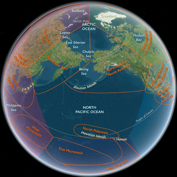
Northern Oceania encompasses Northeast Asia, North Polynesia, and Northwestern North America.
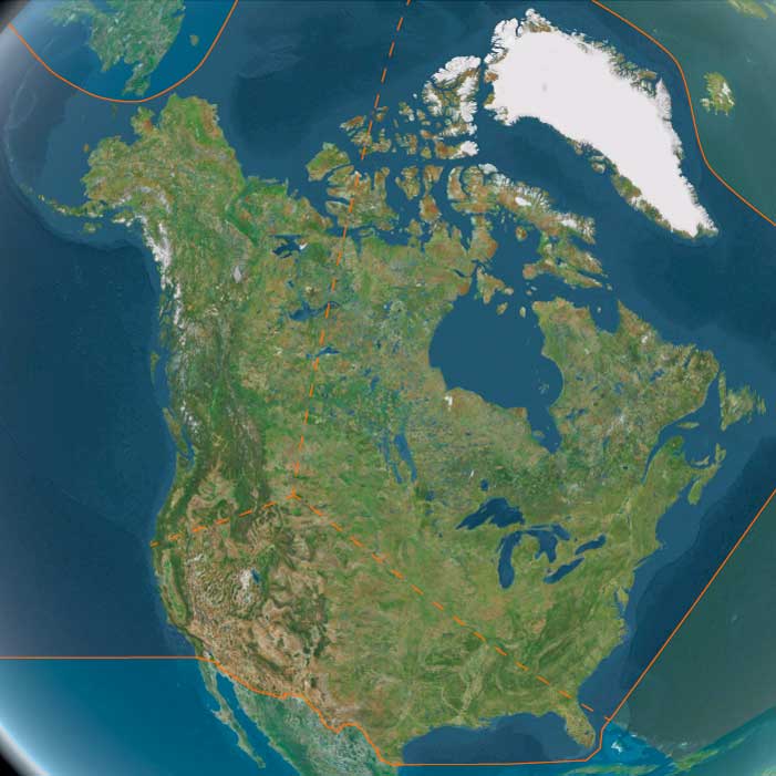
Its southeastern boundary extends from 48.1896851°N, approximately 75 miles south of the Alberta-Saskatchewan-Montana junction, to the Pacific Ocean at Cape Mendocino. To the immediate northwest of this line lies the Pacific Northwest.
In Canada, Alberta and British Columbia form the border with the United States, while to the north lie Nunavut, the Northwest Territories, Yukon, and Alaska.
The eastern boundary at 110°W was originally designated as the Fourth Meridian of the Dominion Land Survey. However, due to the limitations of early surveying techniques, the meridian was placed slightly west of this longitude. Since 1905, the Fourth Meridian has served as the entire boundary between Alberta and Saskatchewan and continues northward as the dividing line between Nunavut and the Northwest Territories above 70°N.
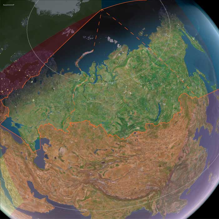
Northern Oceania's western boundary, at 130°E, roughly aligns with the division between Siberia and the Russian Far East, corresponding to Russia’s Siberian and Far Eastern federal districts. This boundary terminates above the Amur River, which has historically marked the border between Russia and China’s Heilongjiang province. The northernmost point of China, in Mohe City, lies along this river.
The southwestern boundary separates most of Japan’s northernmost major island, Hokkaido, from Honshu and the rest of the Japanese archipelago.
HistoryAtlas contains 401 entries for Northern Oceania from the Paleolithic period to 1899.
Narrow results by searching for a word or phrase or select from one or more of a dozen filters.
Northeastern Eurasia (49,293 – 28,578 BCE): Upper Pleistocene I — Steppe, Ice, and the Making of the Northern Corridor
Geographic and Environmental Context
During the late Pleistocene, Northeastern Eurasia extended from the Ural Mountains to the Pacific, encompassing the mammoth-steppe plains of East Europe and Western Siberia, the Altai–Yenisei uplands, and the Amur–Okhotsk–Bering frontier of Northeast Asia.
It was not a single region but a triadic system of worlds:
-
East Europe, the western steppe edge, framed by the Don, Dnieper, and Oka valleys — a land of loess terraces and braided rivers supporting dense megafaunal herds.
-
Northwest Asia, the Siberian interior, from the Urals through the Ob–Irtysh–Yenisei corridor to the Altai, where glacial basins and intermontane valleys served as refugia amid vast permafrost plains.
-
Northeast Asia, the Pacific rim and Beringian shelf, where tundra-steppe met coastal polynyas, bridging the continents long before human migration reached the New World.
Across these subregions, the environment graded from continental aridity in the west to maritime cold along the Pacific — a spectrum of adaptation that tied Eurasia together along its northern rim.
Climate and Environmental Shifts
The interval encompassed alternating Dansgaard–Oeschger warmings and Heinrich cold pulses leading into the Last Glacial Maximum.
-
In East Europe, permafrost advanced to the Dnieper and Don basins; vegetation alternated between steppe grassland and dwarf-shrub tundra.
-
In Northwest Asia, continental cold and aridity dominated; the Ob and Yenisei braided into unstable channels; loess and dust storms swept the forelands of the Urals and Altai.
-
In Northeast Asia, cold was tempered by oceanic moisture. Ice-edge upwellings in the Okhotsk and Bering seas sustained rich marine ecosystems, even as inland basins froze.
Periodic interstadial thaws re-greened the valleys, drawing herds northward and humans with them; stadials drove retreat to riverine refugia.
The result was a dynamic equilibrium of expansion and contraction rather than a single glacial standstill.
Lifeways and Settlement Patterns
All three worlds supported high-latitude foraging economies built on mobility, storage, and memory of place.
-
In East Europe, loess-terrace camps overlooked reindeer and mammoth migration corridors. Semi-recurrent bases at Kostenki, Sungir, and along the Dnieper combined hunting, butchery, and craft production.
-
In Northwest Asia, the Altai foothills and Minusinsk Basin hosted recurrent winter shelters, while open Ob–Yenisei valleys served for summer mammoth and bison hunts.
-
In Northeast Asia, river-mouth camps and coastal flats supported dual economies of inland big-game and maritime sealing and fishing. Seasonal movements linked river confluences, upland passes, and shelf-edge hunting grounds.
Each subregion achieved local stability through broad prey portfolios and cyclical mobility tuned to glacial rhythms.
Technology and Material Culture
A shared Upper Paleolithic technological grammar spanned the entire northern corridor:
-
Blade and microblade industries, adapted to portable composite weapons, formed the technological backbone from the Don to the Anadyr.
-
Bone, antler, and ivory were fashioned into points, awls, harpoons, and eyed needles — evidence for tailored fur clothing and cold-weather dwellings.
-
Obsidian sources in the Altai and Kamchatka and flint quarries in the Don basin anchored far-flung exchange networks.
-
Personal adornment — beads of tooth, ivory, shell, and amber — and ochre burials underscored enduring symbolic systems linking the Eurasian north to the rest of the Upper Paleolithic world.
The breadth of these parallels reveals not isolation but interoperability across extreme distance.
Movement and Interaction Corridors
Northeastern Eurasia was defined by movement — the continual negotiation between ice, water, and wind.
-
The Steppe–River Network: Don–Volga–Ural–Ob–Yenisei channels allowed seasonal following of herds and diffusion of tool types and ornaments.
-
The Altai–Mongolia Crossroads: A mountainous hinge connecting western and eastern populations, where genetic and cultural exchanges mixed Siberian and East Asian lineages.
-
The Amur–Okhotsk–Bering Rim: Shelf and river corridors provided both overland and coastal pathways toward Beringia, the eventual gateway to the Americas.
These arteries made the northern fringe not an end of settlement but a conveyor of innovation and populationbetween continents.
Cultural and Symbolic Expressions
Symbolic behavior mirrored subsistence breadth.
Engraved bones, ivory figurines, and ochred burials appear in all three subregions, expressing a shared spiritual engagement with animals and ancestors.
Altai and Don sites yield portable art and ivory figures, while the Amur and Lena valleys preserve carved bone and antler motifs of reindeer and mammoth.
Fire-ringed hearths and ritual hearth renewals suggest continuity of place and group identity across generations.
In these expressions, the northern peoples joined the global Upper Paleolithic symbolic sphere while imprinting it with an Arctic signature of endurance and cyclical return.
Environmental Adaptation and Resilience
Resilience depended on technological insulation, ecological diversity, and social connectivity.
Fur clothing, hide shelters, and stored fuel allowed wintering at 60–70° N; seasonal migration between coast, river, and plateau distributed risk; and wide alliance networks permitted exchange of mates, materials, and knowledge across immense ranges.
When one valley froze, another thawed — and people already knew the way.
Genetic and Linguistic Legacy
Populations rooted in this corridor carried the genetic foundations of later Arctic and Beringian peoples.
From East Europe through the Altai to the Amur, gene flow linked Eurasia’s west and east, seeding the ancestry of the First Americans and shaping linguistic substrates later echoed in circumpolar families.
Northeastern Eurasia thus became the cradle of the circumpolar continuum — a trans-Beringian cultural ecology that would persist for tens of millennia.
Transition Toward the Last Glacial Maximum
By 28,578 BCE, ice sheets and permafrost deepened, narrowing the habitable band to river valleys and steppe oases.
Yet humans remained throughout, their territories contracting but not vanishing.
The East European plains anchored the west, the Altai–Yenisei belt sustained the interior, and the Amur–Bering coast reached outward toward a new continent.
Northeastern Eurasia therefore stands as a model of The Twelve Worlds principle: its subregions were self-contained in ecology yet outward-looking in connection, bound less by shared geography than by the long, unbroken thread of movement — the first great northern highway of the human story.
Northeast Asia (49,293 – 28,578 BCE): Upper Paleolithic I — Mammoth-Steppe, Sheltered Coasts, and First Long Ranges
Geographic and Environmental Context
Northeast Asia includes eastern Siberia east of the Lena River to the Pacific, the Russian Far East (excluding the southern Primorsky/Vladivostok corner), northern Hokkaidō (above its southwestern peninsula), and extreme northeastern Heilongjiang.
-
Anchors: the Lower/Middle Amur and Ussuri basins, the Sea of Okhotsk littoral (Sakhalin, Kurils), Kamchatka, the Chukchi Peninsula (with Wrangel Island offshore), northern Hokkaidō, and seasonally emergent shelves along the Bering Sea and northwest Pacific.
Ancient North Siberians and the Deep Eurasian Split
The earliest securely identified human population associated with Northeast Asia belongs to a previously unknown lineage now termed the Ancient North Siberians (ANS). Genomic evidence from the Yana River sites (Yana RHS) indicates that these peoples were established in northeastern Siberia by at least 38,000 years ago, well before the Last Glacial Maximum.
The ANS diverged from Western Eurasians shortly after Western Eurasians themselves separated from East Asians, placing the ANS at a pivotal early junction in Eurasian population history. Culturally and biologically distinct, they adapted to extreme high-latitude environments long before the formation of later Siberian populations.
Crucially, these early inhabitants are not ancestral to most later Siberians and do not represent a continuous population into the Holocene. Instead, they form an early, now largely vanished branch of Eurasian humanity whose genetic legacy survives only in diluted form.
Climate and Environmental Shifts
-
Last Glacial Maximum (c. 26,500–19,000 BCE) dominated the latter half of this interval: colder, drier conditions; permafrost pushed south; sea level ~100 m lower exposed broad coastal plains.
-
Inland mammoth-steppe mosaics (grass–forb) alternated with open larch; coastlines were wider, with ice-edge polynyas supporting marine life.
Subsistence and Settlement
-
Big-game foraging focused on mammoth, woolly rhinoceros, horse, bison, and reindeer on river terraces (Aldan–Amur–Anadyr).
-
Coastal scouts used intertidal flats and pack-ice edges to take seals, walrus, seabirds, and winter fish.
-
Camps clustered at confluences, aeolian bluffs, and paleo-shorelines; repeated seasonal use left dense knapping scatters and hearths.
Technology and Material Culture
-
Blade and microblade industries from local obsidian (e.g., Hokkaidō, Kamchatka) and high-quality chert; hafted composite points for thrusting/spear-throwing.
-
Bone/antler/ivory harpoons, awls, eyed needles; tailored cold-weather clothing and boots.
-
Personal adornment: drilled tooth/shell pendants, beads, engraved bone; ochre widely used.
Movement and Interaction Corridors
-
River highways: Lena–Aldan–Amur trunks guided seasonal migrations.
-
Shelf-edge “kelp highway” along the Okhotsk–Bering coasts supported over-ice travel in winter and nearshore voyaging in summer.
-
Wrangel–Chukchi–Beringia arcs linked Northeast Asia to the sub-glacial refugium on the far side of the strait.
Cultural and Symbolic Expressions
-
Carved animal figurines and engraved bones reflect close predator–prey cosmologies.
-
Ochre burials and hearth-centered activity zones suggest shared Upper Paleolithic mortuary and domestic traditions.
Environmental Adaptation and Resilience
-
High mobility between coast–river–upland zones diversified diets and buffered risk.
-
Cold-weather tailoring, layered shelters (snow/skin windbreaks), and fuel provisioning enabled wintering at high latitudes.
Genetic and Linguistic Legacy
-
Ice-age Northeast Asian groups contributed key ancestry to Beringian populations; these, in turn, fed the founding gene pool of the First Americans.
-
Deep links formed here between Arctic–sub-Arctic foragers that later radiated across the North Pacific rim.
Transition Toward the Next Epoch
By 28,578 BCE, foragers in Northeast Asia had mastered periglacial ecologies and coastal shelves. As climate wobble and deglaciation approached, river and shoreline corridors would become even more crucial for movement, exchange, and eventual trans-Beringian dispersals.
Northern North America (49,293 – 28,578 BCE): Upper Pleistocene I — Ice Margins, Continental Gateways, and the First Migrations
Geographic and Environmental Context
During the late Pleistocene, Northern North America stretched across a landscape undergoing immense geological transformation. The advance and retreat of the Laurentide and Cordilleran ice sheets shaped a continent of alternating refugia and barriers. The region’s three great subregions—Northwestern, Northeastern, and Gulf & Western North America—each represented a distinctive interface between ice, land, and sea.
-
Northwestern North America bridged Asia and the Americas through the vast, exposed Beringian landmass. Grassy steppes, braided rivers, and polynyas along the Bering and Chukchi shelves linked Siberia to Alaska.
South of the continental ice, the Yukon and Kuskokwim basins opened to interior plains and the Gulf of Alaska’s wide glacial fjords. -
Northeastern North America was dominated by the Laurentide ice complex and its proglacial lakes—ancestral Iroquois, Algonquin, and Champlain basins—framed by newly deglaciated river valleys.
The Great Lakes corridor, the St. Lawrence–Hudson axis, and emerging Atlantic forelands formed the core of early post-glacial forager landscapes. -
Gulf & Western North America stretched from the Gulf Coast and Southern Plains across the deserts and canyons of the Southwest to the California littoral and Channel Islands.
Its mosaic of pluvial lakes, estuaries, and upwelling-rich coasts provided a warm-water counterpoint to the glacial north.
Together these zones composed a continental hinge between Ice-Age Eurasia and the Americas—each subregion a stage in the story of human dispersal and adaptation to the extremes of a changing world.
Climate and Environmental Shifts
The period encompassed the height of the Last Glacial Maximum. Yet regional variation produced a continent of contrasts:
-
In the Northwest, severe cold and aridity dominated inland Beringia, though coastal polynyas and summer grasslands offered productivity.
-
In the Northeast, alternating Dansgaard–Oeschger warm pulses and Heinrich cold snaps drove cycles of ice advance and retreat, spawning huge meltwater floods and loess plains.
-
In the Gulf & Western corridor, cooler but relatively stable climates supported pluvial lake systems and broad river valleys; along California’s margin, coastal upwelling made the Pacific rim one of the richest marine environments on Earth.
Low sea levels united Alaska and Siberia, widened the Pacific and Gulf shelves, and created continental interiors laced with temporary lakes, dunes, and glacial outwash plains—landscapes of constant flux but enduring opportunity.
Lifeways and Settlement Patterns
Northern North America during this interval was a frontier of mobility—a patchwork of exploratory movements, seasonal circuits, and, by the end of the epoch, enduring forager traditions.
-
In the Northwest, big-game hunters pursued mammoth, bison, and horse across the Beringian grasslands. Seasonal camps clustered at river confluences and bluff edges, while coastal groups ventured onto land-fast ice and ice-edge polynyas for seals and seabirds.
These were small, mobile bands accustomed to long circuits between steppe and shore. -
In the Northeast, later arrivals followed the retreating ice margins into proglacial valleys. Fluted-point traditions reveal expert hunters tracking caribou, elk, and deer across freshly deglaciated terrain.
Camps on river terraces and kame plains served as transient bases for butchery and tool repair rather than long-term villages. -
In the Gulf & Western regions, climatic moderation and ecological diversity allowed sustained occupation. Coastal foragers exploited shellfish, fish, and marine mammals along the expanded California and Gulf shelves, while interior hunters roamed canyonlands and pluvial basins in pursuit of camelids, horses, and later deer and pronghorn.
Rockshelters and spring-fed oases formed the nuclei of repeated seasonal use.
Across all three subregions, subsistence strategies balanced large-game hunting, aquatic foraging, and strategic mobility—the adaptive triad that defined Ice-Age resilience.
Technology and Material Culture
From Beringia to the Gulf, technology reflected shared Upper Paleolithic roots tempered by local innovation.
-
Northwestern assemblages featured blade and microblade industries in high-quality chert and obsidian, with inset composite points, burins, and sewing needles for tailored skins.
-
Northeastern traditions emphasized fluted projectile points, prismatic blades, and scrapers crafted from long-distance lithic sources, signaling wide-ranging exchange and expertise in stone selection.
-
Gulf & Western toolkits relied on flake–blade technology, early hafting, fire use, and pigment processing, suited to mixed desert, canyon, and littoral ecologies.
Throughout the region, ochre pigments and personal ornaments (drilled teeth, shells, beads) reveal symbolic continuity with the larger circumpolar Upper Paleolithic world.
Movement and Interaction Corridors
Northern North America’s human geography was defined by corridors of ice, water, and stone:
-
The Beringian steppe and the Yukon–Mackenzie trench formed the first continental highway, linking Siberia to interior North America.
-
The ice-free Pacific coast—the embryonic “kelp highway”—offered a maritime alternative, dotted with refugia along Alaska’s and British Columbia’s fjorded shores.
-
As deglaciation advanced, the St. Lawrence, Great Lakes, and Mississippi basins became arteries of migration and trade.
-
Farther south, the Rio Grande–Gila–Colorado network and the Gulf estuaries tied the interior to marine resources.
Through these routes, populations spread, merged, and diverged, laying the demographic foundations of later Holocene cultural provinces.
Cultural and Symbolic Expressions
Symbolic life across Northern North America echoed Eurasian antecedents yet developed distinctive local signatures.
Ochre-stained hearths, portable ornaments, and structured camp layouts indicate social memory and ritual behavior.
In both Beringia and the Great Lakes heartland, burials with pigment and grave goods suggest shared beliefs in ancestral continuity.
These expressions, modest in scale yet rich in meaning, anchored social cohesion in landscapes that demanded both cooperation and constant movement.
Environmental Adaptation and Resilience
Resilience was achieved through mobility, diversification, and knowledge of seasonality:
-
Layered clothing, snow shelters, and fire technology extended human presence deep into subarctic zones.
-
In milder belts, foragers exploited estuaries, riverine wetlands, and pluvial lakes, moving along altitudinal and hydrological gradients.
-
Coastal populations learned to synchronize with marine cycles; interior hunters tracked herd migrations across vast steppes.
This adaptive plasticity allowed human groups to colonize environments ranging from glacial fjords to desert basins—a testament to the flexibility that made the Americas habitable at the height of global cold.
Transition Toward the Last Glacial Maximum
By 28,578 BCE, Northern North America stood at the threshold of transformation.
Ice sheets approached their greatest extent, closing interior corridors but leaving narrow coastal and riverine refuges.
Populations in Beringia maintained a tenuous bridge between continents, while others expanded southward along the Pacific and Gulf margins into unglaciated refugia.
The region thus embodied the Twelve Worlds principle: a set of distinct yet interdependent subregions—each self-contained, each connected through migration, exchange, and shared adaptation—that together forged the human foothold on a glacial continent.
Northwestern North America (49,293 – 28,578 BCE) Upper Paleolithic I — Beringian Grasslands, Ice-Edge Shores, and First Entrants
Geographic and Environmental Context
Northwestern North America includes Alaska, western Canada (Alberta, British Columbia, Yukon and Northwest territory and Nunavut west of 110°W) Alaska, Washington State, northern Idaho, and the northwestern portions of Montana, Oregon, and California.
Anchors: the Bering Strait & Seward Peninsula, Brooks Range & North Slope, Yukon–Kuskokwim and Copper–Cook Inlet basins, the Gulf of Alaska & Aleutians, the Inside Passage/Haida Gwaii and outer coast of British Columbia, the Stikine–Skeena–Fraser–Columbia plateaus and canyons, Puget Sound, and the Klamath–Redwood coast of NW California.
-
Exposed Beringia knitted Siberia to Alaska under low sea levels; broad coastal shelves flanked the Gulf of Alaska.
-
Inland, open steppe–tundra spread south of continental ice; river corridors (early Yukon, Kuskokwim) laced the landscape.
Climate & Environmental Shifts
-
Peak Last Glacial conditions: cold, dry, windy; sea ice season long on the northern shelf; polynyas sustained rich marine life along the Bering and Chukchi margins.
Subsistence & Settlement
-
Big-game foraging focused on mammoth, bison, horse, and caribou on river terraces and upland saddles.
-
Ice-edge foraging used landfast ice for seal and sea-bird harvests where accessible.
-
Small, mobile camps recur at bluff edges and confluences; hearths, knapping floors, and butchery areas typical.
Technology & Material Culture
-
Blade–microblade traditions from high-quality chert and obsidian; inset composite points, scrapers, burins.
-
Bone/antler points and awls; sewn skin garments (needles) for deep cold.
Movement & Interaction Corridors
-
Seward Peninsula ⇄ Interior Yukon ridgeways; Kuskokwim–Copper cross-drainages; coastal “kelp highway” reconnaissance along the Gulf of Alaska during ice-free months.
Cultural & Symbolic Expressions
-
Ochre-stained features; portable ornaments (drilled teeth, shell) reflect Upper Paleolithic symbolic commonalities across the north.
Environmental Adaptation & Resilience
-
High mobility and broad prey portfolios buffered risk; cold-weather tailoring and snow shelters extended wintering range.
Transition
On the eve of deglaciation, foragers had mapped river and shelf ecologies that would guide later migrations as ice sheets retreated.
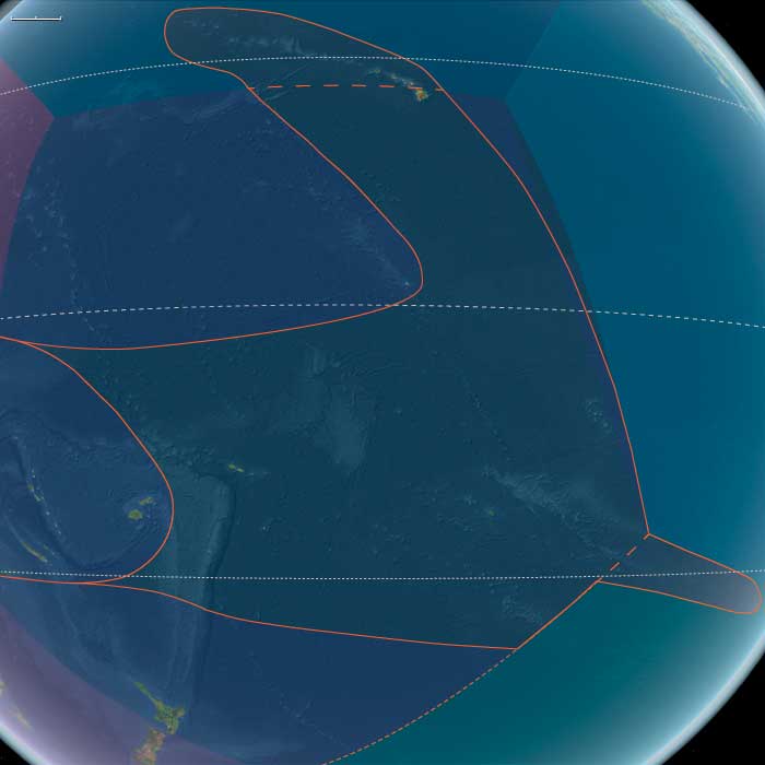
Polynesia (49,293 – 28,578 BCE): Upper Paleolithic I — Volcanic Arcs, Reef Foundations, and the Architecture of Isolation
Geographic & Environmental Context
During the later Pleistocene, the Polynesian sector of the Pacific was a scattered domain of volcanic peaks, emerging atolls, and widening reef flats—a geography still entirely devoid of humans but already constructing the natural architecture that would one day sustain them.
The region spanned three great arcs of islands:
-
The Hawaiian–Emperor chain in the north, including Oʻahu, Maui, Molokaʻi, Kauaʻi, Niʻihau, and Midway, where high volcanic forms dominated the subtropics.
-
The central–western archipelagos—Tonga, Samoa, the Cook and Society Islands, the Marquesas, Tuvalu, and Tokelau—a mixture of high volcanic islands, raised limestone platforms, and embryonic atolls.
-
The eastern fringe—future Pitcairn and Rapa Nui—where lone volcanic edifices rose from deep ocean basins, linked only by the great South Pacific gyres and currents.
Sea level stood ~100 m lower than today, exposing vast coastal benches and broad shelves around high islands. Many modern lagoons lay dry, their reef rims fossilized in the air; others built episodically with interglacial warm phases. Across the region, reef, volcano, and ocean interacted in long cycles of uplift and subsidence—the slow choreography that would, over tens of millennia, produce the Polynesian Triangle’s intricate geography.
Climate & Environmental Shifts
The epoch was framed by full glacial conditions—cooler sea-surface temperatures, stronger trade winds, and a sharply defined dry season.
-
Atmosphere and Ocean: Strengthened trades drove upwelling along many leeward coasts, favoring cool, nutrient-rich nearshore waters. Seasonal dust episodes and winter surf reworked coastal benches, while the intertropical convergence zone (ITCZ) oscillated northward and southward with orbital rhythms.
-
Late-Glacial Variability: Even within the long glacial, brief mild interstadials brought short-lived reef growth spurts and pulses of vegetation recovery. Cooler phases depressed the coral-algal community but expanded coastal steppe and dry scrub.
-
Volcanic Activity: Continuous effusive volcanism in the Hawaiian Big Island and intermittent eruptions in the Societies, Marquesas, and Cooks rejuvenated landscapes, built fresh lava plains, and created ephemeral crater lakes and ash-fed soils.
Overall, Polynesia’s climate oscillated between cool, windy glacial stability and short warming pulses that allowed the reef crest and forest line to advance and retreat in rhythm with the global climate.
Biota & Baseline Ecology (No Human Presence)
Every island was its own closed laboratory of evolution.
-
Marine Life:
Coral communities fluctuated with sea level and temperature, but even under glacial suppression, shallow fringing reefs persisted. Fish, mollusk, turtle, and seabird populations were immense, their only predators sharks and seals. On outer banks like Midway, Tokelau, and Tuvalu, monk seals and turtles bred in numbers far exceeding modern densities. -
Terrestrial Life:
The higher islands—Hawaiʻi, Tahiti, Samoa, the Marquesas—carried dense montane forests in windward belts and dry woodland or grass steppe on leeward slopes. Cloud forests crowned the summits, capturing mist even under glacial dryness. Each island hosted unique, isolated assemblages of birds, insects, and plants, evolving in splendid isolation. -
Avian Realms:
Seabird supercolonies occupied cliffs and stacks, fertilizing soils with guano and enriching nearshore ecosystems. On atolls and cays, the air was dense with terns, boobies, and petrels—an avian kingdom uninterrupted by human disturbance.
Environmental Processes & Dynamics
-
Reef and Lagoon Evolution: Lower sea levels exposed broad reef flats, which weathered into limestone benches; with each brief warming, corals recolonized and built new terraces—a staircase of future lagoons.
-
Volcano–Erosion Cycles: Heavy rainfall on high islands carved deep amphitheaters (e.g., Waiʻanae, Koʻolau, and Tahiti’s ancient calderas), while aridity on leeward slopes preserved lava plains and dunes.
-
Marine Productivity: Upwelling zones around island chains created feeding grounds for pelagic fish and whales; kelp-like macroalgae likely formed dense nearshore beds in cooler zones, anchoring early “reef forest” ecologies.
-
Atmospheric Circulation: Persistent trades sculpted the cloud belts that would later define Polynesian ecological duality—lush windward valleys and dry leeward coasts.
Long-Term Significance
By 28,578 BCE, Polynesia’s physical and biological foundations were firmly in place:
-
Volcanic arcs had matured into high-island chains with deep, fertile amphitheaters and developing river networks.
-
Coral reef systems, though suppressed by glacial cooling, had established their long-term frameworks, ready to surge during Holocene sea-level rise.
-
Forest and reef ecologies had stabilized into enduring zonations—ridge forests, dry scrub, coastal strand, reef-flat, and pelagic edge—that would persist through the Holocene.
The epoch thus created Polynesia’s essential blueprint: a world of towering volcanic islands, expanding reef terraces, seabird-sustained fertility, and unbroken ecological isolation.
In the ages to come, these formations would become the living stage for one of Earth’s greatest human voyaging traditions—a future civilization built upon the deep-time architecture of glacial Polynesia.
North Polynesia (49,293 – 28,578 BCE): Upper Paleolithic I — Volcanic High Islands, Reef Beginnings, and Seabird Kingdoms
Geographic & Environmental Context
North Polynesia includes the Hawaiian Islands chain except Hawaiʻi Island (the Big Island) — principally Oʻahu, Maui, Kauaʻi, Molokaʻi, Lānaʻi, Niʻihau — plus Midway Atoll.
-
Anchors: Oʻahu’s twin shield ranges (Koʻolau, Waiʻanae) with deeply incised gulches; Kauaʻi–Niʻihau as the older high-island pair; Maui Nui as a broad, shallow platform with multiple emergent peaks; Midway Atoll as a carbonate cap on the subsiding Emperor–Hawaiian chain.
-
Sea level sat well below modern during glacial maxima, exposing wide reef flats and coastal benches.
Climate & Environmental Shifts
-
Late Pleistocene glacial climate: cooler SSTs, stronger trade-wind seasonality; broad coastal steppe–scrub around high-island skirts.
-
Episodic dust, stronger winter surf; reef growth pulsed between coolings.
Biota & Baseline Ecology (No Human Presence)
-
Seabird rookeries dense on offshore stacks and atolls (proto-Midway); Hawaiian monk seals hauled out on remote beaches.
-
Native forests atop ridges were a mosaic of cloud forest and dry woodland; streams were clear, with endemic fish/invertebrates.
Long-Term Significance
This epoch set the geomorphic template: high islands with fertile amphitheaters, narrow coastal plains, and nascent reef systems—conditions that would later support intensive Polynesian agro-ecologies.
Siberia has paleontological significance, as it contains bodies of prehistoric animals from the Pleistocene Epoch, preserved in ice or in permafrost.
Specimens of Goldfuss cave lion cubs, Yuka the mammoth and another woolly mammoth from Oymyakon, a woolly rhinoceros from the Kolyma, and bison and horses from Yukagir have been found.
One of the largest-known volcanic events of the last 251 million years of Earth's geological history formed the Siberian Traps.
Volcanic activity continued here for a million years and some scientists consider it a possible cause of the "Great Dying" about 250 million years ago, estimated to have killed 90% of species existing at the time.
The questions of how, when, and why the first peoples entered the Americas remain subjects of active research, though recent genomic advances have significantly refined our understanding. While there is general agreement that the Americas were first settled by peoples who migrated from Asia across Beringia, the migration patterns, timing, and genetic origins have proven far more complex than previously recognized.
Archaeological evidence suggests that widespread human habitation of the Americas occurred during the late glacial period (roughly 16,500-13,000 years ago), following the Last Glacial Maximum. However, sites like White Sands, New Mexico, suggest human presence as early as 21,000-23,000 years ago, potentially during the height of glaciation.
Whole-genome studies have revolutionized understanding of Native American origins, revealing that while most ancestry stems from a shared founding population, at least four distinct streams of Eurasian migration contributed to present-day and prehistoric Native American populations. Ancient DNA analysis of individuals like the 12,600-year-old Anzick-1 child (associated with Clovis artifacts) confirms genetic continuity between early inhabitants and modern Native Americans, contradicting theories of population replacement.
Current research supports a model involving initial migration from a structured Northeast Asian source population, followed by a period of isolation in Beringia, and subsequent coastal migration into the Americas. This founding population then diversified within the continent, splitting into northern and southern lineages around 14,500-17,000 years ago. Additionally, some Amazonian populations show genetic signatures suggesting ancestry from a second source related to indigenous Australasians, indicating an even more complex founding history.
Rather than simple single versus multiple migration models, the genetic evidence points to a nuanced process involving multiple ancestral streams, periods of isolation, rapid expansion, and subsequent diversification within the Americas.
Northeastern Eurasia (28,577 – 7,822 BCE): Late Pleistocene–Early Holocene — Beringian Migrations, Salmon Economies, and the First Pottery Traditions
Geographic & Environmental Context
At the end of the Ice Age, Northeastern Eurasia—stretching from the Urals to the Pacific Rim—was a vast, deglaciating world of river corridors, boreal forests, and emerging coasts. It included three key cultural–ecological spheres:
-
Northwest Asia — the Ob–Irtysh–Yenisei heartlands, Altai piedmont lakes, and Minusinsk Basin, bounded by the Ural Mountains to the west. Here, deglaciation produced pluvial lake systems, and forest belts climbed into the Altai foothills.
-
East Europe — from the Dnieper–Don steppe–forest margins to the Upper Volga–Oka and Pripet wetlands, a corridor of interlinked rivers and pluvial basins supporting rich postglacial foraging.
-
Northeast Asia — the Amur and Ussuri basins, the Sea of Okhotsk littoral, Sakhalin and the Kuril–Hokkaidō arc, Kamchatka, and the Chukchi Peninsula—a maritime–riverine realm where early Holocene foragers developed salmon economies and pottery traditions under the warming Pacific westerlies.
Together these subregions formed a continuous arc of adaptation spanning tundra, taiga, and coast—an evolutionary laboratory for the technologies and traditions that would later circle the entire North Pacific.
Climate & Environmental Shifts
-
Bølling–Allerød (14,700–12,900 BCE): Rapid warming and higher precipitation expanded boreal forests and intensified riverine productivity across Eurasia’s north. Salmon runs strengthened in the Amur and Okhotsk drainages; pluvial lakes filled the Altai basins.
-
Younger Dryas (12,900–11,700 BCE): A temporary cold–dry reversal restored steppe and tundra, constraining forests to valleys; lake levels fell; inland mobility increased.
-
Early Holocene (after 11,700 BCE): Stable warmth and sustained moisture drove forest advance (pine, larch, birch) and high lake stands; sea levels rose along the Okhotsk and Bering coasts, flooding older plains and establishing modern shorelines.
These oscillations forged adaptable forager systems able to pivot between large-game mobility and aquatic specialization.
Subsistence & Settlement
Across the northern tier, lifeways diversified and semi-sedentism began to take root:
-
Northwest Asia:
Elk, reindeer, beaver, and fish formed broad-spectrum diets. Lakeside camps in the Altai and Minusinsk basins became seasonal home bases, while Ob–Yenisei channels hosted canoe or raft mobility. Forest nuts and berries expanded plant food options in warm phases. -
East Europe:
Along the Dnieper, Don, and Upper Volga, foragers targeted elk, red deer, horse, and beaver, exploiting riverine fish and waterfowl. Repeated occupations at lake outlets and confluences reflect increasing site permanence and food storage. -
Northeast Asia:
The Amur–Okhotsk region pioneered salmon-based economies, anchoring early Holocene villages at river confluences and estuarine terraces. Coasts provided seal, shellfish, seabirds, and seaweeds, while inland foragers pursued elk and musk deer. Winter sea-ice hunting alternated with summer canoe travel along the Sakhalin–Kuril–Hokkaidō chain.
This mosaic of economies—lake fishers, river hunters, and sealers—reflected the continent’s growing ecological diversity.
Technology & Material Culture
Innovation was continuous and regionally distinctive:
-
Microblade technology persisted across all subregions, with refined hafting systems for composite projectiles.
-
Bone and antler harpoons, toggling points, and gorges evolved for intensive fishing and sealing.
-
Ground-stone adzes and chisels appeared, enabling woodworking and boat construction.
-
Early pottery, first along the Lower Amur and Ussuri basins (c. 15,000–13,000 BCE), spread across the Russian Far East—among the world’s earliest ceramic traditions—used for boiling fish, storing oils, and processing nuts.
-
Slate knives and grindstones at Okhotsk and Amur sites show specialized craft economies.
-
Personal ornaments in amber, shell, and ivory continued, while sewing kits with eyed needles and sinew thread supported tailored, waterproof clothing.
These toolkits established the technological template for later northern and Pacific Rim foragers.
Movement & Interaction Corridors
-
Ob–Irtysh–Yenisei river systems funneled movement north–south, linking the steppe with the taiga and tundra.
-
Altai and Ural passes maintained east–west contact with Central Asia and Europe.
-
Dnieper–Volga–Oka networks merged the European forest-steppe into the greater Eurasian exchange field.
-
In the Far East, the Amur–Sungari–Zeya–Okhotsk corridor unified interior and coast, while the Sakhalin–Kuril–Hokkaidō arc allowed short-hop voyaging.
-
Across the Bering Strait, fluctuating sea levels intermittently connected Chukotka and Alaska, maintaining Beringian gene flow and cultural exchange.
These conduits supported both biological and technological diffusion at a continental scale.
Cultural & Symbolic Expressions
-
Ochre burials with ornamented clothing and ivory or antler goods reflect deep symbolic continuity from the Upper Paleolithic.
-
Petroglyphs and engravings in the Altai and Minusinsk basins, and later in Kamchatka, depict large animals, waterbirds, and solar motifs.
-
Amur basin figurines and carved marine-mammal and fish effigies attest to ritualized relationships with food species.
-
In the Far East, early evidence of first-salmon and bear-rite traditions foreshadows later Ainu and Okhotsk ceremonialism.
Across all subregions, water and game remained the core of spirituality, connecting people to cyclical abundance and ancestral landscapes.
Environmental Adaptation & Resilience
Foragers across Northeastern Eurasia met environmental volatility with creative versatility:
-
Zonal mobility (taiga–tundra–coast) and multi-season storage (dried meat, smoked fish, rendered oils) stabilized food supply.
-
Boat and ice technologies extended reach across seasons.
-
Broad-spectrum diets cushioned against climatic downturns.
-
Flexible dwellings and social alliances allowed fission and fusion as resources shifted.
-
Memory landscapes—engraved rocks, ritual mounds, named rivers—preserved continuity through spatial change.
Genetic and Linguistic Legacy
The Beringian population standstill during the Late Glacial created a deep ancestral pool for both Paleo-Inuit and First American lineages, while reciprocal migration reconnected Chukchi, Kamchatkan, and Amur populations after sea-level rise.
These long-lived networks seeded circum-Pacific cultural parallels in salmon ritual, dog-traction, maritime hunting, and composite toolkits, forming the northern backbone of later trans-Pacific cultural continuity.
Long-Term Significance
By 7,822 BCE, Northeastern Eurasia had become one of the world’s great centers of forager innovation:
-
Northwest Asia’s pluvial lakes fostered early semi-sedentism and the first rock art of Siberia.
-
East Europe’s river–lake foragers stabilized broad-spectrum economies bridging steppe and forest.
-
Northeast Asia’s salmon-rich coasts and early pottery traditions created the technological and ritual matrix that would radiate across the North Pacific.
This continental synthesis of aquatic resource mastery, ceramic innovation, and long-range mobility defined the emerging Holocene north—a zone where people and landscape adapted together through water, ice, and memory.