The African South
Related Events
Showing 10 events out of 494 total
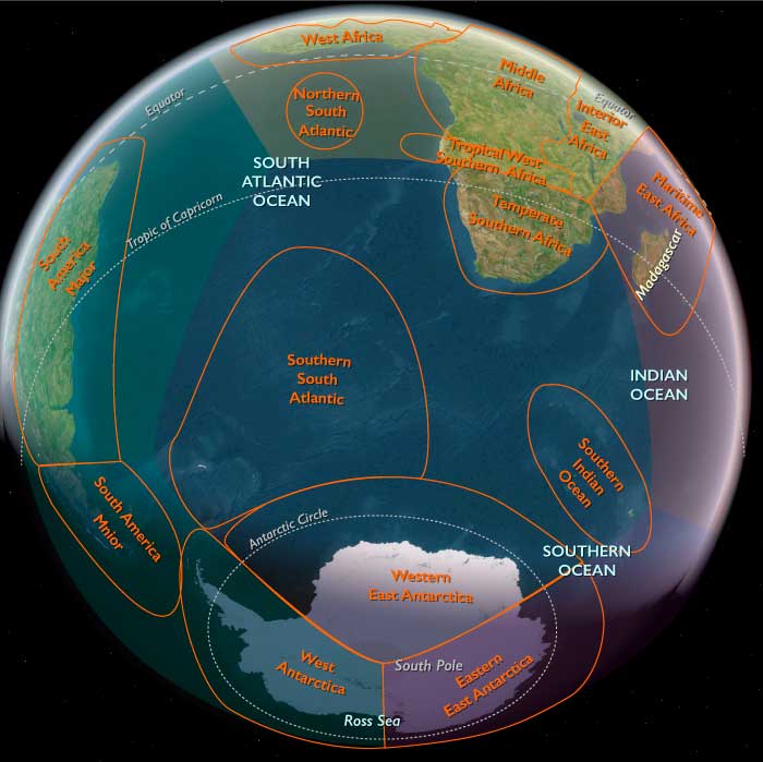
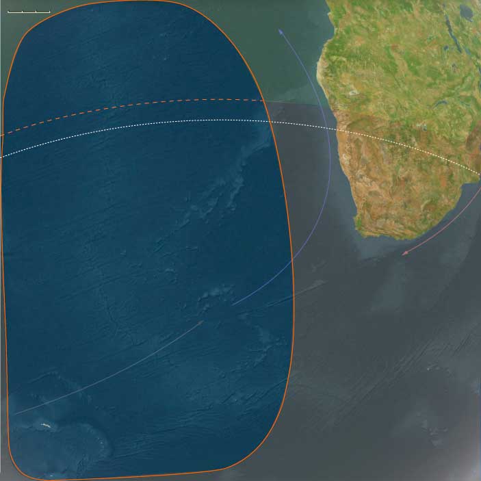
The African South, encompassing the southern subcontinent of Africa, includes the Republic of South Africa, Lesotho, Eswatini (formerly Swaziland), Botswana, southern Mozambique, nearly all of Namibia except its far north, and the western portion of East Antarctica.
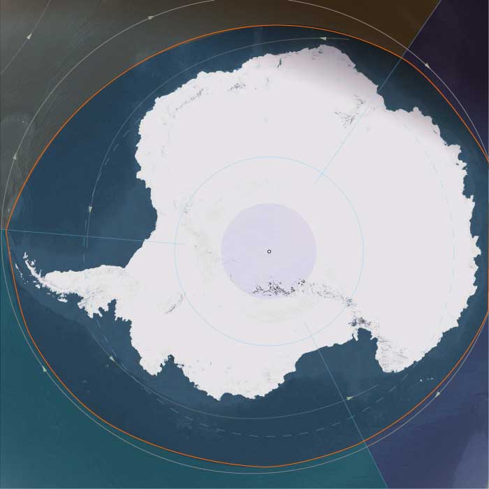
This region also extends into the South Atlantic and Southern Ocean, incorporating Coronation Island (visible above the tip of the Antarctic Peninsula), South Georgia, the South Sandwich Islands, and the remote Tristan da Cunha and Gough Islands in the mid-South Atlantic.
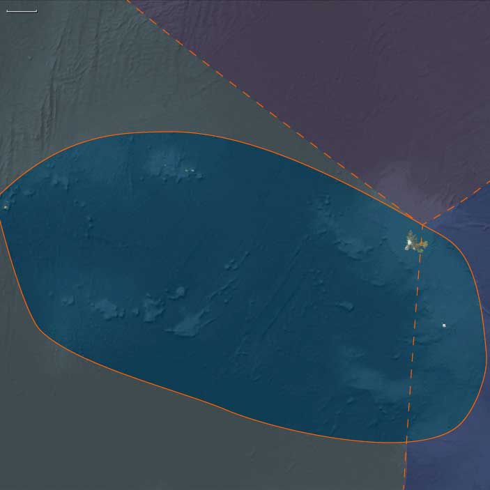
The desolate Kerguelen Islands, marking the convergence of Southern Africa, Australasia, and Afroasia, form its easternmost point.
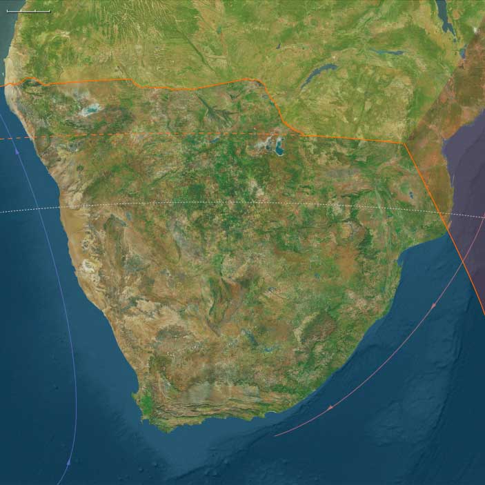
The northern boundary runs just south of the Namibia-Angola border, tracing the Caprivi Strip before reaching the Mababe Depression, northwest of the Okavango Basin.
The northeastern border follows Botswana’s boundary with Zimbabwe, then continues between South Africa’s Drakensberg Range and Kruger National Park, before finally separating Eswatini from Mozambique.
HistoryAtlas contains 554 entries for the African South from the Paleolithic period to 1899.
Narrow results by searching for a word or phrase or select from one or more of a dozen filters.
Homo gautengensis is, as of May 2010, the earliest recognized species in the genus Homo.
While earlier fossils belong to the genus Homo, none have yet been classified in any species.
Analysis announced in May 2010 of a partial skull found decades earlier in South Africa's Sterkfontein Caves near Johannesburg identified the species, named Homo gautengensis by anthropologist Dr Darren Curnoe of the UNSW School of Biological, Earth and Environmental Sciences.
While earlier fossils belong to the genus Homo, none have yet been classified in any species.
The species' first remains were originally discovered in 1977 but had been left largely ignored.
They had been catalogued Stw 53 and were noted as being anomalous.
Identification of H. gautengensis was based on partial skulls, several jaws, teeth and other bones found at various times at the Caves.
It emerged over two million years ago and died out approximately six hundred thousand years years ago, and is believed to have arisen earlier than Homo habilis.
According to Curnoe, who led the research project, Homo gautengensis had big teeth suitable for chewing plant material.
It was "small-brained" and "large-toothed," and was "probably an ecological specialist, consuming more vegetable matter than Homo erectus, Homo sapiens, and probably even Homo habilis."
It apparently produced and used stone tools and may even have made fire, as there is evidence for burnt animal bones associated with H. gautengensis' remains.
Curnoe and South African paleoanthropologist colleague Phillip Tobias believe H. gautengensis stood just over three feet tall and weighed about one hundred and ten pounds.
It walked on two feet when on the ground, "but probably spent considerable time in trees, perhaps feeding, sleeping and escaping predators," Curnoe said.
The researchers believe it lacked speech and language skills.
Due to its anatomy and geological age, researchers think that it was a close relative of Homo sapiens but not necessarily a direct ancestor.
The approximate time of divergence from the common ancestor of all modern human populations was two hundred thousand years ago, based on evidence from studies of molecular biology.
The broad study of African genetic diversity found the ǂKhomani San people to express the greatest genetic diversity among the 113 distinct populations sampled, making them one of fourteen "ancestral population clusters".
The research also located the origin of modern human migration in southwestern Africa, near the coastal border of Namibia and Angola.
The Moderns are taller, more slender, and less muscular than the Neanderthals, with whom they share—perhaps uneasily—the Earth.
Though their brains are smaller in overall size, they are heavier in the forebrain, a difference that may allow for more abstract thought and the development of complex speech.
Yet, the inner world of the Neanderthals remains a mystery—no one knows the depths of their thoughts or how they truly expressed them.
In human genetics, Y-chromosomal Adam (Y-MRCA) is the most recent common ancestor (MRCA) from whom all living people are descended patrilineally (tracing back only along the paternal lines of their family tree)
Recent studies report that Y-chromosomal Adam lived as early as around one hundred and forty-two thousand years ago: older studies estimated Y-MRCA as recent as sixty thousand years ago.
Mitochondrial Eve in the field of human genetics refers to the matrilineal most recent common ancestor (MRCA) of modern humans.
She, in other words, is the woman from whom all living humans today descend, on their mother's side, and through the mothers of those mothers and so on, back until all lines converge on one person.
Because all mitochondrial DNA (mtDNA) is generally passed from mother to offspring without recombination, all mitochondrial DNA (mtDNA) in every living person is directly descended from hers by definition.
Each ancestor (of people now living) in the line back to the matrilineal MRCA had female contemporaries such as sisters, female cousins, etc., and some of these female contemporaries may have descendants living now (with one or more males in their descendancy line), but none of the female contemporaries of the "Mitochondrial Eve" has descendants living now in an unbroken female line.
Anatomically modern and behaviorally modern humans in the southernmost tip of southern Africa inhabit the Klasies River Caves, a series of caves located to the east of the Klasies River mouth on the Tsitsikamma coast in the Humansdorp district of Eastern Cape Province, between 80,000 and 110,000 BCE.
There is a marked difference between the Paleolithic stone technology used in the earliest layers from one hundred and twenty-five thousand years ago years ago, and the superior Mesolithic blades of the seventy-thousand-year-old Howiesons Poort period that used raw material which had been 'mined' twenty kilometers inland.
There is also a differentiation between the Paleolithic food detritus that accumulated underfoot inside the caves one hundred and twenty-five thousand years ago, but is ejected and accumulated into external middens by the Mesolithic occupants circa seventy-five thousand years ago: housekeeping has now become standardized.
The bow and arrow, which allows hunters to attack animals from a secure distance, is, according to some indirect evidence, invented during this period.
Bone arrow points dating to sixty-one thousand years ago have been found at Sibudu Cave in South Africa.
Antarctica (49,293–28,578 BCE): Upper Pleistocene I — The Frozen Continent and Its Oceanic Halo
Geographic and Environmental Context
During the height of the Late Pleistocene, Antarctica stood as the coldest, driest, and most isolated world on Earth—a continent sealed in ice and girdled by the Southern Ocean.
The great landmass divided naturally into three broad realms:
-
East Antarctica, the immense polar plateau rising more than 3 km above sea level, draped in ice more than 4 km thick and stretching from the Transantarctic Mountains to the Indian Ocean rim.
-
West Antarctica, a lower, fractured terrain comprising the Antarctic Peninsula, Marie Byrd Land, and the Amundsen–Ross embayments, fringed by vast floating shelves.
-
The subantarctic ring—the nearby island arcs of South Georgia, the South Orkneys, the South Sandwich Islands, Bouvet, and the Prince Edward–Marion chain—sat just beyond the continental ice but within its climatic orbit, forming Antarctica’s ecological frontier with the world’s oceans.
These divisions—polar plateau, continental rim, and subantarctic ring—behaved less like a single geography than like three interconnected systems whose unity was maintained by ice, wind, and current.
Climate and Environmental Shifts
The period between 49,000 and 28,500 BCE encompassed the build-up to the Last Glacial Maximum.
-
Temperature: Mean annual values across the plateau were 10–15 °C colder than today; coastal sectors remained below freezing even in summer.
-
Ice extent: The East Antarctic Ice Sheet thickened and spread toward the coast, while the smaller West Antarctic ice masses merged, grounding on the continental shelf. Overall, Antarctica’s ice volume reached its greatest Quaternary extent.
-
Sea level: Global levels fell ~120 m, exposing continental shelves and expanding grounded ice.
-
Atmosphere: Lower greenhouse-gas concentrations and stronger katabatic winds intensified polar deserts in the interior.
-
Ocean: Sea-ice fronts advanced far north in winter, yet polynyas—open-water oases—persisted along parts of the coast, sustaining remarkable marine productivity.
The result was a planet tipped toward cold equilibrium: Antarctica at its broadest and most luminous, radiating sunlight back into space and anchoring global climate.
Flora, Fauna, and Ecology
Antarctica itself supported only microbial, algal, and cryptogamic life confined to small ice-free niches, while its surrounding seas and subantarctic islands hosted some of Earth’s richest cold-water ecosystems.
-
Terrestrial oases: Along the Dry Valleys, the Antarctic Peninsula, and scattered nunataks, thin melt-season films supported cyanobacteria, mosses, lichens, and minute invertebrates.
-
Coastal wildlife: Adélie and early emperor-penguin lineages bred on stable sea-ice platforms; skuas and petrels nested on rocky ledges.
-
Marine systems: Krill, copepods, and under-ice algae flourished beneath seasonal pack ice, feeding whales, seals, and seabirds.
-
Subantarctic ring: Islands like South Georgia and the Prince Edward group carried tussock grass, moss, and sprawling rookeries of albatrosses, petrels, and fur seals—vital nodes in the circum-polar web.
Though barren by continental standards, Antarctica’s margins were alive with motion, its biological clock synchronized to the annual advance and retreat of ice.
Human Presence and Global Context
No humans had ever set foot on this continent or its islands.
Elsewhere, Homo sapiens spread across Africa, Eurasia, and Sahul, but Antarctica lay far beyond the technological reach of any Pleistocene mariner.
Its isolation rendered it the world’s ultimate terra incognita, absent even from myth.
Yet indirectly, it mattered: the continent’s albedo, sea-ice cycles, and carbon sequestration steered the climates within which human civilizations would one day arise.
Antarctica was already humanity’s silent climate engine.
Movement and Interaction Corridors
Though devoid of people, the region was a crossroads for wind, current, and life:
-
The Antarctic Circumpolar Current (ACC) encircled the continent, connecting the Atlantic, Indian, and Pacific Oceans into a single conveyor.
-
The westerly wind belt (“roaring forties” – “furious fifties”) drove surface circulation and upwelling that fed krill blooms.
-
Whales, seals, and seabirds migrated along these highways from every southern continent, forming a truly circum-global ecological network.
These corridors prefigured the pathways of future exploration, commerce, and science.
Symbolic and Conceptual Role
In human terms, Antarctica existed only as an absence—a mythic void beyond any known horizon.
Had Ice-Age peoples imagined it, it might have represented the under-world of ice, a place where sun and earth froze in perpetual night.
In geological reality, it was the earth’s mirror, reflecting heat and regulating balance: a physical metaphor for stasis at the edge of creation.
Environmental Adaptation and Resilience
Antarctica’s ecosystems, though sparse, showed immense stability:
-
Glacial resilience: Microbial and moss communities endured multiple glacial advances, recolonizing from refugia during brief interstadials.
-
Marine adaptation: Krill and fish species evolved antifreeze proteins, surviving under permanent cold.
-
Carbon storage: Ice-sheet expansion sequestered atmospheric CO₂, tightening Earth’s glacial grip yet ensuring reversibility when melting resumed.
In every process—wind, ice flow, nutrient recycling—the system demonstrated the capacity of life and climate to adapt through feedback and equilibrium.
Transition Toward the Glacial Maximum
By 28,578 BCE, Antarctica had reached near-peak glacial extent.
The East Antarctic plateau remained unaltered in its frozen dominion; the West Antarctic shelves thickened; and the subantarctic islands thrived as refugia for the Southern Ocean’s living abundance.
Humanity still knew nothing of this world, yet its influence touched every other: it cooled the tropics, lowered the seas, and sculpted the very margins of habitable Earth.
In the grand pattern of The Twelve Worlds, Antarctica stood as the still point of the planet’s climatic wheel—its icy heart, unseen but omnipresent, binding the glacial age together.
Southern Africa (49,293 – 28,578 BCE): Upper Pleistocene I — Coasts, Grasslands, and Wetland Arcs at the Ice Age’s Edge
Geographic and Environmental Context
In the late Pleistocene, Southern Africa formed a twin world divided by latitude and rainfall, yet united by mobility and exchange.
To the south stretched Temperate Southern Africa — the Cape littoral, Drakensberg massif, Highveld grasslands, Karoo basins, and Namaqualand semi-deserts.
To the north lay Tropical West Southern Africa, encompassing the Okavango Delta, Etosha Pan, Caprivi wetlands, and the fog-fed Skeleton Coast of Namibia.
-
Along the Cape coast, sea levels stood nearly 100 m lower, exposing vast continental shelves and rich strand-plain hunting grounds.
-
Inland, grasslands extended across the Highveld and Limpopo basins, while the Drakensberg and Lesotho highlands were chilled by frost and occasional glacial patches.
-
Northward, the Okavango–Caprivi–Etosha system acted as an alternating chain of seasonal refugia amid the broader aridity of the Last Glacial Maximum.
-
The Namib fog belt, running down to the Skeleton Coast, linked desert and sea in a unique microclimate corridor.
Southern Africa thus was not a single environment but a pair of ecological theaters — a temperate coast–upland mosaic in the south and a wetland–desert archipelago in the north.
Climate and Environmental Shifts
The epoch coincided with intensifying glacial cold across the globe.
Yet within this Ice-Age frame, Southern Africa remained a refuge — drier and cooler than today but never locked in ice.
-
In the temperate south, reduced rainfall contracted woodlands and expanded fynbos, karoo scrub, and open grasslands; winter storms strengthened along the Atlantic margin.
-
In the tropical north, summer monsoon belts retreated, leaving intermittent floods in the Okavango and Etosha basins and stabilizing the persistent fog regime on the coast.
-
Glacial cooling produced strong altitudinal zonation: frost-line vegetation in the Drakensberg, thornveld and savanna below, and semi-desert farther west.
Seasonal contrasts were sharper, but the diversity of habitats offered resilience few Ice-Age regions could match.
Lifeways and Settlement Patterns
Foragers across Southern Africa built dual economies that revolved around mobility between stable refugia and opportunistic resource zones.
-
Temperate foragers (the ancestors of the strandlopers) lived between coast and grassland, harvesting shellfish, fish, and seabirds along the exposed Cape plains, while inland groups hunted zebra, wildebeest, and springbok on the Highveld and Karoo.
Rock shelters in the Cederberg and Drakensberg served as cold-season refuges and social nodes. -
Tropical West Southern foragers organized life around water: fishing, trapping, and gathering in the Okavango floodplains during high water, then shifting to pan edges and spring corridors as the delta receded.
Others ranged along the Skeleton Coast for strandings, shellfish, and eggs, returning inland before the fog belt dried out.
This north–south complementarity gave the region a latitudinal rhythm of survival: coastal–grassland circuits in the south mirrored wetland–pan circuits in the north, both sustained by deep ecological mapping.
Technology and Material Culture
Both worlds drew from the Late Middle Stone Age technological repertoire but tuned it to their environments.
-
Stone industries: flake and blade cores of quartz, chert, or calcrete, with backed pieces and retouched scrapers emerging late.
-
Organic tools: bone points, hide awls, digging sticks weighted by stone rings, and fiber nets.
-
Symbolic and practical innovation: ostrich-eggshell beads for adornment and, more crucially, OES flasks for water storage — a hallmark of Southern African ingenuity.
-
Ochre was ubiquitous in both ritual and hide treatment, anchoring a long symbolic tradition.
While distinct in raw material, these toolkits spoke a common technological language of light, portable adaptability.
Movement and Interaction Corridors
Southern Africa’s inhabitants were consummate travelers, moving through a lattice of ecological corridors rather than fixed territories.
-
In the south, the Cape–Karoo–Namaqualand coastline functioned as a continuous forager highway linking shellfish coves and inland grassland basins.
The Drakensberg passes opened seasonal routes between coastal plains and upland hunts. -
In the north, floodplain ridges and island chains of the Okavango guided east–west movement; Omiramba fossil rivers connected wetlands to Etosha; and Zambezi–Chobe–Cuando levees provided trans-basin crossings.
Even the foggy Skeleton Coast formed a linear migration route, its beaches serving as landmarks and occasional larders.
Through such corridors, material styles and ritual customs circulated widely, linking populations across what would later be defined as desert and delta.
Cultural and Symbolic Expressions
Symbolic life flourished amid this ecological variety.
In the south, ochre-stained burials, bead caches, and early rock art motifs in Cederberg shelters hint at ritual storytelling and ancestral marking of place.
In the north, pigment caches, hearth renewal rituals at pan-edge camps, and the exchange of bead strings performed similar social functions.
Across both zones, color, fire, and pattern embodied continuity: every hearth and painted stone a reaffirmation of belonging in landscapes that never stood still.
Environmental Adaptation and Resilience
Resilience in Southern Africa came from diversification and knowledge rather than abundance.
Foragers mastered micro-climates, timing their movements with rainfall, flood pulses, and marine upwelling cycles.
Technologies such as ostrich-eggshell water storage, tailored hides, and lightweight shelters allowed year-round mobility.
Social networks stretched across biomes, ensuring mutual support during drought or cold snaps.
In contrast to the glaciated north, Southern Africa remained a living subcontinent — its people agents, not refugees, of the Ice Age.
Transition Toward the Last Glacial Maximum
By 28,578 BCE, both subregions were firmly established as enduring refugia:
-
Temperate Southern Africa maintained rich coastal and grassland economies, its rock-shelter traditions deepening into the symbolic complexity that would define the Later Stone Age.
-
Tropical West Southern Africa sustained flexible wetland–desert lifeways, its networks of floodplain, pan, and fog-shore camps forming one of the most intricate adaptive mosaics on Earth.
Together they formed a southern hinge of resilience — a world of foragers who thrived, not merely endured, beneath glacial skies.
Southern Africa’s dual systems of coast and delta would endure into the Holocene, exemplifying the Twelve Worlds principle: that human stability arises from ecological plurality, not uniformity.